Saturday 11 January 2020

PLIENSBACHIAN: APODEROCERAS

This stunning specimen with her regal ridges — and small anomaly — is an Apoderoceras ammonite. Apoderoceras are an extinct genus of cephalopod, an active predatory mollusk belonging to the subclass Ammonoidea.

Apoderoceras is, in fact, a wonderful example of sexual dimorphism within ammonites as the macroconch (putative female) shell grew to diameters in excess of 40 cm – many times larger than the diameters of the microconch (putative male) shell. Apoderoceras has been found in the Lower Jurassic of Argentina, Hungary, Italy, Portugal, and most of North-West and central Europe, including as this one is, the United Kingdom. She was found on the beaches of Charmouth in West Dorset, in South West England, then prepped expertly by the lovely and talented Lizzie Hingley.

Neither Apoderoceras nor Bifericeras donovani are strictly index fossils for the Taylori subzone, the index being Phricodoceras taylori. Note that Bifericeras is typical of the earlier Oxynotum Zone, and ‘Bifericeras’ donovani is doubtfully attributable to the genus.

The International Commission on Stratigraphy (ICS) has assigned the First Appearance Datum of genus Apoderocerasas and of Bifericeras donovani the defining biological marker for the start of the Pliensbachian Stage of the Jurassic, 190.8 ± 1.0 million years ago.  As the brilliant Murray Edmunds points out, this lovely large specimen (macroconch) of Apoderoceras is likely a female. Her larger body perfected for egg production.

Cat's Paw Sutures of Apoderoceras. Simon Guscott Photo
Apoderoceras (Family Coeloceratidae) appears out of nowhere in the basal Pliensbachian and dominates the ammonite faunas of NW Europe. It is superficially similar to the earlier Eteoderoceras (Family Eoderoceratidae, of the Raricostatum Zone), but on closer inspection can be seen to be quite different.  It is, therefore, an invader species and its ancestry is somewhat cryptic.

The Pacific ammonite Andicoeloceras, known from Chile, appears quite closely related and may be ancestral, but the time correlation of Pacific and NW European ammonite faunas is challenging. Even if Andicoeloceras is ancestral to Apoderoceras, no other preceding ammonites attributable to Coeloceratidae are known.

Perhaps there are clues in the Pliensbachian of Canada. We shall have to see. Apoderoceras remains present in NW Europe throughout the Taylori Subzone, showing endemic evolution. It becomes progressively more inflated during this interval of time, the adult ribs more distant, and there is evidence that the diameter of the macroconch evolved to become larger. At the end of the Taylori Subzone, Apoderoceras disappeared as suddenly as it appeared in the region, and ammonite faunas of the remaining Jamesoni Zone are dominated by the Platypleuroceras–Uptonia lineage, generally assigned — but erroneously, IMO!— to the Family Polymorphitidae.

In the NW European Taylori Subzone, Apoderoceras is accompanied — as well as by the Eoderoceratid, B. donovani, which is only documented from the Yorkshire coast, although I know of examples from Northern Ireland — by the oxycones Radstockiceras (quite common) and Oxynoticeras (very rare), the late Schlotheimid, Phricoderoceras (uncommon: note P. taylori is a microconch, and P. lamellosum the macroconch), and the Eoderoceratid, Tetraspidoceras (very rare).

Thank you to Murray Edmunds for his advice and insights on Apoderoceras and the ammonite faunas of the Pacific and NW Europe. You are deeply awesome, my friend! Check out Murray’s Research Gate site for more interesting tidbits.

https://www.researchgate.net/profile/Murray_Edmunds; the photo above of the Cat's Paw Sutures of an Apoderoceras from Dorset are from the lovely Simon Guscott. Look at the wee belemnite that has been washed into the body chamber. Appreciate you!

Friday 10 January 2020

LOWER ALBIAN AMMONITE

Lovely defined sutures on this rather involute, high-whorled ammonite from the middle part of the Lower Albian in the Mahajanga Province, northwestern Madagascar. This specimen of Phylloceras velledae (Michelin) has a shell with a small umbilicus, arched, acute venter, and at some growth stage, falcoid ribs that spring in pairs from umbilical tubercles, disappearing on the outer whorls.

While this large island off the southeast coast of Africa is known more for exotic lemurs, rainforests & beaches, it also boasts some of the world's loveliest fossils.

This specimen is from a quarry near the top of an escarpment, 3 km to the west of the village of Ambatolafia (coordinates: Lat. 16.330 23.600 S, Long. 46.120 10.20 E). Judging from plate tectonic reconstruction (Stampfli & Borel, 2002), the area was located in middle latitudes within the tropical-subtropical climatic zone at palaeo-latitudes of 40E45.S in the late Early Cretaceous of the early Albian.


Wednesday 8 January 2020

ARMOURED AGNATHA

This lovely specimen is an armoured agnatha jawless bony fish, Victoraspis longicornualis, from Lower Devonian deposits of Podolia, Ukraine.

Victoraspis longicornualis was named by Anders Carlsson and Henning Bloom back in 2008. The new osteostracan genus and species were described based on material from Rakovets' present-day Ukraine. This new taxon shares characteristics with the two genera Stensiopelta (Denison, 1951) and Zychaspis (Javier, 1985).

Agnatha is a superclass of vertebrates. This fellow looks quite different from our modern Agnatha, which includes lamprey and hagfish. Ironically, hagfish are vertebrates who do not have vertebrae. Sometime in their evolution, they lost them as they adapted to their environment. Photo: Fossilero Fisherman

Ref: Carlsson, A. & Blom, H. Paläont. Z. (2008) 82: 314. https://doi.org/10.1007/BF02988898

Tuesday 7 January 2020

SUTURES, RIDGES AND LOBES

Ammonitic Suture Detail
Ammonites were predatory, squidlike creatures that lived inside coil-shaped shells.

Like other cephalopods, ammonites had sharp, beak-like jaws inside a ring of squid-like tentacles that extended from their shells. They used these tentacles to snare prey, — plankton, vegetation, fish and crustaceans — similar to the way a squid or octopus hunt today. Catching a fish with your hands is no easy feat, as I'm sure you know. But the ammonites were skilled and successful hunters. They caught their prey while swimming and floating in the water column.

Within their shells, they had a number of chambers, called septa, filled with gas or fluid that were interconnected by a wee air tube. By pushing air in or out, they were able to control their buoyancy in the water column.

They lived in the last chamber of their shells, continuously building new shell material as they grew. As each new chamber was added, the squid-like body of the ammonite would move down to occupy the final outside chamber.

They were a group of extinct marine mollusc animals in the subclass Ammonoidea of the class Cephalopoda. These molluscs, commonly referred to as ammonites, are more closely related to living coleoids — octopuses, squid, and cuttlefish) than they are to shelled nautiloids such as the living Nautilus species.

Ammonites first appeared about 240 million years ago, though they descended from straight-shelled cephalopods called bacrites that date back to the Devonian, about 415 million years ago, and the last species vanished in the Cretaceous–Paleogene extinction event.

Ammonites were prolific breeders that evolved rapidly. If you could cast a fishing line into our ancient seas, it is likely that you would hook an ammonite, not a fish. They were prolific back in the day, living (and sometimes dying) in schools in oceans around the globe.  We find ammonite fossils (and plenty of them) in sedimentary rock from all over the world. In some cases, we find rock beds where we can see evidence of a new species that evolved, lived and died out in such a short time span that we can walk through time, following the course of evolution using ammonites as a window into the past. For this reason, they make excellent index fossils. An index fossil is a species that allows us to link a particular rock formation, layered in time with a particular species or genus found there. Generally, deeper is older, so we use the sedimentary layers rock to match up to specific geologic time periods, rather the way we use tree-rings to date trees.

Ammonites have intricate patterns on their shells called sutures. The different suture patterns tell us what time period the ammonite is from. If they are geometric with numerous undivided lobes and saddles and eight lobes around the conch, we refer to their pattern as goniatitic, a characteristic of Paleozoic ammonites.

If they are ceratitic with lobes that have subdivided tips; giving them a saw-toothed appearance and rounded undivided saddles, they are likely Triassic. If they have lobes and saddles that are fluted, with rounded subdivisions instead of saw-toothed, they are likely Jurassic or Cretaceous.

The Ammonoidea can be divided into six orders:
  • Agoniatitida, Lower Devonian - Middle Devonian
  • Clymeniida, Upper Devonian
  • Goniatitida, Middle Devonian - Upper Permian
  • Prolecanitida, Upper Devonian - Upper Triassic
  • Ceratitida, Upper Permian - Upper Triassic
  • Ammonitida, Lower Jurassic - Upper Cretaceous
In some classifications, these are left as suborders, included in only three orders: Goniatitida, Ceratitida, and Ammonitida. Once you get to know them, ammonites in their various shapes and suturing patterns make it much easier to date a rock formation at a glance.

Their fossil shells are pleasing to the eye, usually taking on a planispiral form— although there are some helically spiralled and fully crazy spiralled forms — known as heteromorphs.

Heteromorphs come in a variety of shapes and sizes. They must have intrigued and mystified those who were first to find them as they do not have an intuitive shape at all for a marine predator.

The beautiful plate you see on the upper left here showing two ammonites is from Sowerby (1837) and is one of the very first scientifically accurate studies of heteromorph ammonites. We see similar species to the heteromorph on the right of the plate in the Nanaimo Group of Vancouver Island, British Columbia.

The beautiful plate to the right shows some of the heteromorph ammonites from Pictet's Paleontology in its second edition (1853-57). Some of the figures are copied from Astier or d'Orbigny works, not included in the first edition.

Ammonite shells have been collected for millennia. During medieval times they were believed to be snakes that had been turned into stone and were sold to people going on pilgrimages. They have been found in archaeological sites in many parts of the world. We find them in archaeological remains spanning human history, across cultures and civilizations.

Ammonites are prized for their scientific and aesthetic value and have been used as building materials, jewellery, amulets, charms to aid in the hunt, religious totems amongst other things. The original discus used by the ancient Greeks in their Olympics was a fossilized ammonite.

A great temple to the god Amon was built at Karnak in Upper Egypt around c. 1785. It is from Amon that we get his cephalopod namesake, the ammonites and also the name origin for the compound ammonia or NH3.


Monday 6 January 2020

GRAPTOLITES

Graptolites — Graptolita — are colonial animals. The biological affinities of the graptolites have always been debatable. Originally regarded as being related to the hydrozoans, graptolites are now considered to be related to the pterobranchs, a rare group of modern marine animals.

The graptolites are now classed as hemichordates (phylum Hemichordata), a primitive group that probably shares a common ancestry with the vertebrates.

In life, many graptolites appear to have been planktonic, drifting freely on the surface of ancient seas or attached to floating seaweed by means of a slender thread. Some forms of graptolite lived attached to the sea-floor by a root-like base. Graptolite fossils are often found in shales and slates. The deceased planktonic graptolites would sink down to and settle on the seafloor, eventually becoming entombed in the sediment and are thus well preserved.

Graptolite fossils are found flattened along the bedding plane of the rocks in which they occur. They vary in shape, but are most commonly dendritic or branching (such as Dictoyonema), saw-blade like, or "tuning fork" shaped, such as Didymograptus murchisoni.

An excellent resource on graptolites is Old as the Hills. You can find them at:

Sunday 5 January 2020

GENESIS OF THE ARIETIDAE

Arietidæ plate using heliogravure copper platting
The lovely plate is from the Genesis of the Arietidæ, shared as part of Contributions to Knowledge, 673. pages vii-xi, 1-223; 14 Plates and 35 Woodcuts. Smithsonian, Washington, 1889 by Professor Alpheus Hyatt, an American zoologist and paleontologist.

Hyatt co-founded the American Naturalist, serving as their editor from 1867 to 1870. He became a professor of paleontology and zoology at Massachusetts Institute of Technology in 1870, where he taught for eighteen years, then Professor of Biology and Zoology at Boston University from 1877 until his death in 1902.

Hyatt favoured the use of héliogravure, the technique used here to illustrate some of the best early American ammonite plates. Heliogravure is a type of photogravure or intaglio printmaking or photo-mechanical process whereby a copper plate is grained and then coated with a light-sensitive gelatin tissue exposed to a film positive, then etched.

In France, the correct term for photogravure is héliogravure, while the French term photogravure refers to any photo-based etching technique. The earliest forms of photogravure were developed by two of the original pioneers of photography —  first by Nicéphore Niépce in France in the 1820s, and later Henry Fox Talbot in England.

Niépce was seeking a means to create photographic images on plates that could then be etched and used to make prints on paper with a traditional printing press. Niépce's early images were amongst the first photographs — pre-dating daguerreotypes and the later wet collodion photographic process. Henry Talbot, the inventor of the calotype paper negative process, wanted to make paper prints that would not fade. He worked on his photomechanical process in the 1850s and patented it in 1852 ('photographic engraving') and 1858 ('photoglyphic engraving').

Photogravure in its mature form was developed in 1878 by Czech painter Karel Klíč, who built on Talbot's research. This process, the one still in use today, is called the Talbot-Klič process.

Because of its high quality and richness, photogravure was used for both original fine art prints and for photo-reproduction of works from other media such as paintings. A photogravure is distinguished from rotogravure in that photogravure uses a flat copper plate etched rather deeply and printed by hand, while in rotogravure, as the name implies, a rotary cylinder is only lightly etched, and it is a factory printing process for newspapers, magazines, and packaging.

Many of my favourite paleontological plates were created using this technique. We're fortunate that it allows for both a high degree of detail and multiple printings, ensuring that these beautiful and important early works were not lost in time.

S. S. B. (1890). II.—The Genesis of the Arietidæ. By Professor Alpheus Hyatt. Smithsonian Contributions to Knowledge, 673. 4to. pages vii–xi, 1–223; 14 Plates and 35 Woodcuts. (Washington, 1889.). Geological Magazine, 7(7), 325-326. doi:10.1017/S0016756800186790

Talbot's Correspondence: Biography. De Montfort University.

Saturday 4 January 2020

BREADBASKET OF EGYPT

Much of Egypt's history is carved in her rock. We think of Egypt as old, with remarkable human history, but the land that formed this part of the world tells us of a much older time in Earth's past.

Egypt, officially the Arab Republic of Egypt, is a country in the northeast corner of Africa, whose territory in the Sinai Peninsula extends beyond the continental boundary with Asia.

Egypt is bordered by the Gaza Strip (Palestinian territories) and Israel to the northeast, the Gulf of Aqaba and the Red Sea to the east, Sudan to the south, Libya to the west, and the Mediterranean Sea to the north. Across the Gulf of Aqaba lies Jordan, across the Red Sea lies Saudi Arabia, and across the Mediterranean Sea lie Greece, Cyprus and Turkey, although none of these share a land border with Egypt.

Five hundred kilometres southwest of Cairo, the flat sabkha plain stretches in all directions covered by a small layer of dark, round pebbles. There are spectacular limestone pillars dotting the landscape of the wonderful karst topography. This land, once the breadbasket of Egypt and the stomping ground of the Pharaohs, is now ruled by pipelines and rusted-out trucks abandoned as wrecks marking the passage of time. Beneath the sand, rust and human history lie some very interesting geology. This rock has been sculpted both through erosion and at the hands of her craftsmen.

The rock here was formed when the Earth's crust was just beginning to cool, 4 to 2.5 billion years ago, during the Archaean. Other rock dates back to the Proterozoic when the Earth's atmosphere was just beginning to form. The oldest of these are found as inliers in Egypt’s Western Desert. The rocks making up the Eastern Desert are largely late Proterozoic in age, the time when bacteria and marine algae were the principal forms of life.

Throughout the country, this older basement is overlain by Palaeozoic sedimentary rocks. Cretaceous outcrops are common. We also find sediments that tell a story of repeated marine transgression and regressions, sea levels rising and falling, characteristic of the Cenozoic. It is from Egypt's Cenozoic geology that we get the limestones used for the great pyramids.

Limestone and Light: Egypt
The pyramids were built of limestone, granite, basalt, gypsum (mortar), and baked mud bricks. Together they form some of the oldest (and last remaining) wonders of the ancient world. The great pyramids of Giza, with their smooth exteriors carved from fine grain white limestone quarried at Tura on the Giza-plateau, are built from Egypt's much older geologic history.

The limestone from Tura was the finest and whitest of all the Egyptian quarries and chosen for the facing stones for the richest tombs. It is interesting in that it is made up almost entirely of Nummulites. Nummulites are the calcareous chambered shells (tests) of extinct forms of marine, amoeba-like organisms (protozoans) called foraminifera that accumulated in huge quantities during the early Cenozoic. Foraminifera are still alive in the sea today, though none quite as large as Nummulites. For the central chamber, with the sarcophagus of the pharaoh, lovely reddish-pink granite from Aswan was used. The granite helped to take the weight of this massive construction.

Back in 2013, archaeologists made an unlikely find in a cave seven hundred kilometres from Giza. Their find, a 4,600-year-old papyrus scroll, details an ancient shipload of rock, likely destined for  Khufu's pyramid. The papyrus is addressed to Ankh-haf, Khufu’s half-brother, and describes the undertaking of an expedition by a 200-man crew to the limestone quarries near Tura, on the eastern shore of the Nile. After loading the blocks onto their ship, the expedition indented to float down the river Nile for a successful delivery.

The Greek historian Herodotus visited Egypt in the 5th century BC, he described the building of Khufu's pyramid by more than 100,000 slaves. Those slaves then had the unenviable task of unloading the 2-3 ton blocks, then pulling them across ramps to be dragged to the construction site.  It is estimated that 5.5 million tonnes of limestone, 8,000 tonnes of granite (imported from Aswan), and 500,000 tonnes of mortar were used in the construction of the Great Pyramid.

Friday 3 January 2020

RISE OF THE ANGIOSPERMS

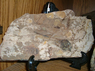
Florissantia sp., from the Allenby Formation, Princeton, BC
Plant fossils are found coast-to-coast in Canada, from 45-million-year-old mosses in British Columbia to fossil forests on Axel Heiberg and Ellesmere islands in the Canadian Arctic.

The early angiosperms developed advantages over contemporary groups — rapid reproductive cycles —  which made them highly efficient, adapting well to "weedy" growth. These modifications, including flowers for the attraction of insect pollinators, proved advantageous in many habitats.

Interaction between plant and pollinator has been a driving force behind the astounding diversification of both flowering plants and insects.

Some of the earliest known flowering plants are found in northeastern British Columbia coalfields. Late Cretaceous (about 101–66 million years ago) floras of the Dawson Creek area of British Columbia, and Milk River, Alberta, reveal increasing dominance by angiosperms. These fossils, while generally resembling some living angiosperms, represent old, extinct families, and their relationships to living groups remain unclear.

At the end of the Cretaceous, the climate cooled, inland seas covering much of western Canada drained, and dinosaurs became extinct. At the boundary between the Cretaceous and Paleogene is evidence of extinction amongst land plants, too. During this interval of mass extinction, the Earth was struck by a massive meteorite. The fallout from this impact is preserved in boundary sediments in southern Saskatchewan as a pale clay, rich in rare earth elements such as iridium.

In the early Paleogene period (66–56 million years ago), we entered the age of mammals. Paralleling the rise of mammals is the rise of modern flora, which consists overwhelmingly of flowering plants.

Early Paleogene fossils are found over much of Alberta —  Red Deer River, Lake Wabamun coalfields and Robb to Coal Valley coalfields —  and southern Saskatchewan —  Eastend area to Estevan coalfield —  to as far north as Ellesmere Island. These floras reveal a variety of flowering plants, including members of the sycamore, birch and walnut families, but the most abundant fossil plants are the katsuras and the dawn redwood, now native only to southeastern Asia.

In the mid-Paleogene period (56–34 million years ago) brief climatic warming coincided with the rapid diversification of flowering plants. Eocene fossils in British Columbia (Princeton, Kamloops and Smithers areas) reveal increasing numbers of modern plant families, with extinct species of birch, maple, beech, willow, chestnut, pine and fir.

Exceptionally well-preserved fossil forests found on Axel Heiberg and Ellesmere islands in the Canadian Arctic illustrate clearly the contrast between modern Canadian vegetation and the floras of a much warmer past. These fossil forests, 40 to 60 million years old, consist of large stumps, many over 1 m in diameter, preserved where they grew, still rooted in ancient soil.

Thick mats of leaf litter that formed the forest floor reveal the types of plants inhabiting the forests. Lush redwood and cypress swamps covered the lowlands, while the surrounding uplands were dominated by a mixed conifer and hardwood forest resembling that of modern eastern North America. Even accounting for continental drift, these forests grew well above the Arctic Circle, and bear witness to a time in Canada's past when a cold arctic climatic regime did not exist.

Around 45-50 million years ago, during the middle Eocene, a number of freshwater lakes appeared in an arc extending from Smithers in northern British Columbia, south through the modern Cariboo, to Kamloops, the Nicola Valley, Princeton and finally, Republic, Washington.

The lakes likely formed after a period of faulting created depressions in the ground, producing a number of basins or grabens into which water collected — imagine gorgeous smallish lakes similar to Cultus Lake near Chilliwack, British Columbia.

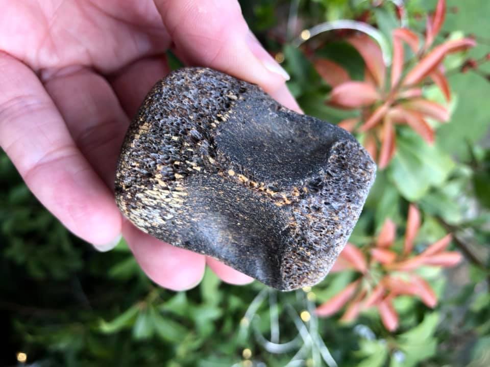
Fossilized wood permineralized in fine-grained sediment
The groaning Earth, pressured by the collision of tectonic plates produced a series of erupting volcanoes around the Pacific Northwest. These spouting volcanoes blew fine-grained ash into the atmosphere and it rained down on the land.

The ash washed into the lakes and because of its texture, and possibly because of low water oxygen levels on the bottoms that slowed decay beautifully preserved the dead remains of plant, invertebrate, and fish fossils —  some in wonderful detail with fascinating and well-preserved flora.

Near the town of Princeton, British Columbia, we see the results of that fine ash in the many fossil exposures. The fossils you find here are Middle Eocene, Allenby Formation with a high degree of detail in their preservation. Here we find fossil maple, alder, fir, pine, dawn redwood and ginkgo material. The Allenby Formation of the Princeton Group is regarded as Middle Eocene based on palynology (Rouse and Srivastava, 1970), mammals (Russell, 1935; Gazin, 1953); freshwater fishes (Wilson, 1977, 1982) and potassium-argon dating (Hills and Baadsgaard, 1967).

Several species of fossilized insects can be found in the area and rare, occasional fossil flowers and small, perfectly preserved fish. More than 50 flowers have been reported (Basinger, 1976) from the Princeton chert locality that crops out on the east side of the Similkameen River about 8 km south of Princeton, British Columbia.

The first descriptions of fossil plants from British Columbia were published in 1870–1920 by J.W. Dawson, G.M. Dawson, and D.P. Penhallow. Permineralized plants were first described from the Princeton chert in the 1970s by C.N. Miller, J.F. Basinger, and others, followed by R.A. Stockey and her students. W.C. Wehr and K.R. Johnson revitalized the study of fossils at Republic with the discovery of a diverse assemblage in 1977.

In 1987, J.A. Wolfe and Wehr produced a United States Geological Survey monograph on Republic, and Wehr cofounded the Stonerose Interpretive Center as a venue for public collecting. Systematic studies of the Okanagan Highlands plants, as well as paleoecological and paleoclimate reconstructions from palynomorphs and leaf floras, continue to expand our understanding of this important Early Eocene assemblage.

One of the sister sites to McAbee, the Driftwood Canyon Provincial Park Fossil Beds, offers an honours system for their site. Visitors may handle and view fossils but are asked to not take them home. Both Driftwood Canyon and McAbee are part of that arc of Eocene lakebed sites that extend from Smithers in the north, down to the fossil site of Republic Washington, in the south. The grouping includes the fossil sites of Driftwood Canyon, Quilchena, Allenby, Tranquille, McAbee, Princeton and Republic. Each of these localities provides important clues to our ancient climate.

Eocene Plant Fauna / Eohiodon Fish Fossil / McAbee
The fossils range in age from Early to Middle Eocene. McAbee had a more temperate climate, slightly cooler and wetter than other Eocene sites to the south at Princeton, British Columbia, Republic in north-central Washington, in the Swauk Formation near Skykomish and the Chuckanut Formation of northern Washington state. The McAbee fossil beds consist of 30 metres of fossiliferous shale in the Eocene Kamloops Group.

The fossils are preserved here as impressions and carbonaceous films. We see gymnosperm (16 species); a variety of conifers (14 species to my knowledge); two species of ginkgo, a large variety of angiosperm (67 species); a variety of insects and fish remains, the rare feather and a boatload of mashed deciduous material. Nuts and cupules are also found from the dicotyledonous Fagus and Ulmus and members of the Betulaceae, including Betula and Alnus.

We see many species that look very similar to those growing in the Pacific Northwest today. Specifically, cypress, dawn redwood, fir, spruce, pine, larch, hemlock, alder, birch, dogwood, beech, sassafras, cottonwood, maple, elm and grape. If we look at the pollen data, we see over a hundred highly probable species from the site. Though rare, McAbee has also produced spiders, birds (and lovely individual feathers) along with multiple specimens of the freshwater crayfish, Aenigmastacus crandalli.

For insects, we see dragonflies, damselflies, cockroaches, termites, earwigs, aphids, leafhoppers, spittlebugs, lacewings, a variety of beetles, gnats, ants, hornets, stick insects, water striders, weevils, wasps and March flies. The insects are particularly well-preserved. Missing are the tropical Sabal (palm), seen at Princeton.

200 km to the south, fossil leaves and fish were first recognized at Republic, Washington, by miners in the early 1900s. We find the impressive Ensete (banana) and Zamiaceae (cycad) at Eocene sites in Republic and Chuckanut, Washington. Many early workers considered these floras to be of Oligocene or Miocene age. C.A. Arnold described Canadian occurrences of conifers and Azolla in the 1950s. Palynological studies in the 1960s by L.V. Hills, G.E.Rouse, and others and those of fossil fish by M.V.H. Wilson in the 1970–1980s provided the framework for paleobotanical research at several key localities.

With the succession of ice ages that swept down across North America in the Pleistocene, there were four intervening warm periods. These warmer periods help many species, including the genus Oenothera, enjoy four separate waves of colonization — each hybridizing with the survivors of previous waves. This formed the present-day subsection Euoenothera. The group is genetically and morphologically diverse and contains some of the most interesting of the angiosperms.

Today, there are about 145 species of herbaceous flowering plants in the genus Oenothera, all native to the Americas. It is the type genus of the family Onagraceae. We know them by many names — evening primrose, suncups, and sundrops  —  but they are not closely related to the true primroses (genus Primula).

Oenothera flowers are pollinated by insects, such as moths and bees. One of the most interesting things I've learned (thank you, Jim Barkley) is a clever little evolutionary trait exhibited by the beach evening primrose, Oenothera drummondil. These lovelies can actively sense and respond to the buzzing of bees. Marine Veits et al. were able to show that this species has evolved to respond to the sound of bees by producing nectar with a higher sugar concentration, certainly yummy by bee standards — therein attracting more pollinators and increasing the plant species reproductive success.

David R. Greenwood, Kathleen B. Pigg, James F. Basinger, and Melanie L. DeVore: A review of paleobotanical studies of the Early Eocene Okanagan (Okanogan) Highlands floras of British Columbia, Canada, and Washington, USA.

Sauquet H, von Balthazar M, Magallón S, et al. The ancestral flower of angiosperms and its early diversification. Nat Commun. 2017;8:16047. Published 2017 Aug 1. doi:10.1038/ncomms16047

Marine Veits  Itzhak Khait  Uri Obolski, et al. Flowers respond to pollinator sound within minutes by increasing nectar sugar concentration. https://doi.org/10.1111/ele.13331

Photo: Pictured above is a beautiful example of Florissantia sp., an extinct species of angiosperm from Eocene outcrops near Princeton, British Columbia. It is one of the best-preserved specimens I've seen from the Allenby. Florissantia can be found in western North America outcrops dating from the Eocene to the Oligocene, 56 to 23 million years ago.

Thursday 2 January 2020

GRATIFYING GASTROPODA

Gastropods, or univalves, are the largest and most successful class of molluscs. They started as exclusively marine but have adapted well and now their rank spends more time in freshwater than in salty marine environments.

Many are marine, but two-thirds of all living species live in freshwater or on land. Their entry into the fossil record goes all the way back to the Cambrian.

Slugs and snails, abalones, limpets, cowries, conches, top shells, whelks, and sea slugs are all gastropods. They are the second-largest class of animals with over 60,000–75,000 known living species. The two beauties you see here are Turritella, a genus of medium-sized sea snails with an operculum, marine gastropod mollusks in the family Turritellidae. They hail from the Paris Basin and have tightly coiled shells, whose overall shape is basically that of an elongated cone. The name Turritella comes from the Latin word turritus meaning "turreted" or "towered" and the diminutive suffix -ella.

Many years ago, I had the pleasure of collecting in the Paris Basin with a fellow named Michael. I had stalked the poor man from Sunday market to Sunday market, eventually meeting up with him in the town of Gordes. He graciously shared his knowledge of the local fossil localities from the hills south of Calais to Poitiers and from Caen to the Rhine Valley, east of Saarbrücken. I deeply regret losing my notebook from that trip but cherish the fossils and memories.

The Paris Basin has many fine specimens of gastropods. These molluscs were originally sea-floor predators, though they have evolved to live happily in many other habitats. Many lines living today evolved in the Mesozoic. The first gastropods were exclusively marine and appeared in the Upper Cambrian (Chippewaella, Strepsodiscus). By the Ordovician, gastropods were a varied group present in a variety of aquatic habitats. Commonly, fossil gastropods from the rocks of the early Palaeozoic era are too poorly preserved for accurate identification. Still, the Silurian genus Poleumita contains fifteen identified species.

Most of the gastropods of the Palaeozoic belong to primitive groups, a few of which still survive today. By the Carboniferous, many of the shapes we see in living gastropods can be matched in the fossil record, but despite these similarities in appearance the majority of these older forms are not directly related to living forms. It was during the Mesozoic era that the ancestors of many of the living gastropods evolved.

In rocks of the Mesozoic era, gastropods are more common as fossils and their shells often very well preserved. While not all gastropods have shells, the ones that do fossilize more easily and consequently, we know a lot more about them. We find them in fossil beds from both freshwater and marine environments, in ancient building materials and as modern guests of our gardens.

Wednesday 1 January 2020

SKØKKENMØDDINGER

Johnny Scow's Kwakwaka'wakw Kwakiutl House, 1918
Many First Nations sites were inhabited continually for centuries.

The day-to-day activities of each of these communities were much like we have today. Babies were born, meals were served and life followed a natural cycle. 

As coastal societies lived their lives they also left their mark. There are many communities thriving today but we have lost some to time, plague and disease. For those that have been abandoned or gone quiet, we see the remnants of a once thriving village through their totems, skeletons of buildings—and most always through discarded shells and scraps of bone from their food.

These refuse heaps contain a wealth of information about how that community lived, what they ate and what environmental conditions looked like over time. They also provide insight into the local gastronomic record on diet, species diversity, availability and variation.

This physical history provides a wonderful resource for archaeologists in search of botanical material, artifacts, broken cooking implements and my personal favourite, mollusc shells. Especially those formed from enormous mounds of bivalves and clams. We call these middens. Left for a period of time, these unwanted dinner scraps transform through a process of preservation.

Shell middens are found in coastal or lakeshore zones all over the world. Consisting mostly of mollusc shells, they are interpreted as being the waste products of meals eaten by nomadic groups or hunting parties. Some are small examples relating to meals had by a handful of individuals, others are many metres in length and width and represent centuries of shell deposition. In Brazil, they are known as sambaquis, left between the 6th millennium BCE and the beginning of European colonization.

European shell middens are primarily found along the Atlantic seaboard and in Denmark from the 5th millennium BCE (Ertebølle and Early Funnel Beaker cultures), containing the remains of the earliest Neolithisation process (pottery, cereals and domestic animals).

Younger shell middens are found in Latvia (associated with Comb Ware ceramics), Sweden (associated with Pitted Ware ceramics), the Netherlands (associated with Corded Ware ceramics) and Schleswig-Holstein (Late Neolithic and Iron Age). All these are examples where communities practised a mixed farming and hunting/gathering economy.

On Canada's west coast, there are shell middens that run for more than 1 kilometre (0.62 mi) along the coast and are several meters deep. The midden in Namu, British Columbia is over 9 metres (30 ft) deep and spans over 10,000 years of continuous occupation.

Shell middens created in coastal regions of Australia by Indigenous Australians exist in Australia today. Middens provide evidence of prior occupation and are generally protected from mining and other developments. One must exercise caution in deciding whether one is examining a midden or a beach mound. There are good examples on the Freycinet Peninsula in Tasmania where wave action currently is combining charcoal from forest fire debris with a mix of shells into masses that storms deposit above high-water mark.

Shell mounds near Weipa in far north Queensland are claimed to be middens but are actually shell cheniers, beach ridges re-worked by nest mound-building birds. The midden below is from Santa Cruz, Argentina. We can thank Mikel Zubimendi for the photo.

Some shell middens are regarded as sacred sites, such as the middens of the Anbarra of the Burarra from Arnhem Land, a historical region of the Northern Territory of Australia —  a vast wilderness of rivers, rocky escarpments, gorges and waterfalls.

The Danish use the term køkkenmøddinger, coined by Japetus Steenstrup, a Danish zoologist and biologist, to describe shell heaps and continues to be used by some researchers.

So what about these ancient shells is so intriguing? Well, many things, not the least being their ability to preserve the past. Shells have a high calcium carbonate content.

Calcium carbonate is one of my favourite chemical compounds. It is commonly found in rocks —  as the minerals calcite and aragonite, most notably as limestone, which is a type of sedimentary rock consisting mainly of calcite —  and is the main component of pearls, snails, eggs and the shells of marine organisms. About 4% of the Earth's crust is made from calcium carbonate. It forms beautiful marbles and the 70 million-year-old White Cliffs of Dover — calcium carbonate as chalk made from the skeletons of ancient algae.

Time and pressure leach the calcium carbonate, CaCO3, from the surrounding marine shells and help embalm bone and antler artifacts that would otherwise decay. Much of what we know around the modification of natural objects into tools comes from this preservation. The calcium carbonate (CaCO3) in the discarded shells tends to make the middens alkaline, slowing the normal rate of decay caused by soil acidity and leaving a relatively high proportion of organic material —  food remnants, organic tools, clothing, human remains — to sift through and study.

Calcium carbonate shares the typical properties of other carbonates. In prepping fossil specimens embedded in limestone, it is useful to know that limestone, itself a carbonate sedimentary rock, reacts with stronger acids. If you paint the specimen with hydrochloric acid, you'll hear a little fizzling sound as the limestone melts and carbon dioxide is released: CaCO3(s) + 2HCl(aq) → CaCl2(aq) + CO2(g) + H2O(l). I tend to use a 3-5 molar solution, then rinse with plain water.

Calcium carbonate reacts with water saturated with carbon dioxide to form the soluble calcium bicarbonate. Bone already contains calcium carbonate, as well as calcium phosphate, Ca2, but it is also made of protein, cells and living tissue. Decaying bone acts as a sort of natural sponge that wicks in the calcium carbonate displaced from the shells. As protein decays inside the bone, it is replaced by the incoming calcium carbonate, making the bone harder and more durable.

The shells, beautiful in their own right, make the surrounding soil more alkaline, helping to preserve the bone and turn dinner scraps into exquisite scientific specimens for future generations.

Tuesday 31 December 2019

ECHINODERMATA: CRINOIDS

This lovely specimen is Zeacrinites magnoliaeformis, an Upper Mississippian-Chesterian crinoid found by Keith Metts in the Glen Dean Formation, Grayson County, Kentucky, USA.

Crinoids are unusually beautiful and graceful members of the phylum Echinodermata. They resemble an underwater flower swaying in an ocean current. But make no mistake they are marine animals. Picture a flower with a mouth on the top surface that is surrounded by feeding arms. Awkwardly, add an anus right beside that mouth. That's him!

Crinoids with root-like anchors are called Sea Lilies. They have graceful stalks that grip the ocean floor. Those in deeper water have longish stalks up to 3.3 ft or a meter in length.

Then there are other varieties that are free-swimming with only vestigial stalks. They make up the majority of this group and are commonly known as feather stars or comatulids. Unlike the sea lilies, the feather stars can move about on tiny hook-like structures called cirri. It is this same cirri that allows crinoids to latch to surfaces on the seafloor. Like other echinoderms, crinoids have pentaradial symmetry. The aboral surface of the body is studded with plates of calcium carbonate, forming an endoskeleton similar to that in starfish and sea urchins.

These make the calyx somewhat cup-shaped, and there are few, if any, ossicles in the oral (upper) surface called a tegmen. It is divided into five ambulacral areas, including a deep groove from which the tube feet project, and five interambulacral areas between them. The anus, unusually for echinoderms, is found on the same surface as the mouth, at the edge of the tegmen.

Crinoids are alive and well today. They are also some of the oldest fossils on the planet. We have lovely fossil specimens dating back to the Ordovician.

Sunday 29 December 2019

ONCORHYNCHUS NERKA

Oncorhynchus nerka
This toothy specimen is an Oncorhynchus nerka, a Pleistocene Sockeye Salmon from outcrops along the South Fork Skokomish River, Olympic Peninsula, Washington State, USA.

I'd expected to learn that the locality contained a single or just a few partial specimens, but the fossils beds are abundant with large, 45–70 cm, four-year-old adult salmon concentrated in a beautiful sequence of death assemblages.

The specimens include individuals with enlarged breeding teeth and worn caudal fins. It is likely that these salmon acted very similar to their modern counterparts with males partaking in competitive and sneaky tactics to gain access to the sexiest (large and red) females who were ready to mate. These ancient salmon had migrated, dug their nests, spawned and defended their eggs prior to their death. For now, we're referring to the species found here as Oncorhynchus nerka, as they have many of the characteristics of sockeye salmon, but also several minor traits of the Pink Salmon, Oncorhynchus gorbuscha.

Gerald Smith, a retired University of Michigan professor was shown the specimens and recognized them as Pleistocene, a time when the northern part of North America was undergoing a series of glacial advances and retreats that carved their distinctive signature into the Pacific Northwest. It looks as though this population diverged from the original species about one million years ago, possibly when the salmon were deposited at the head of a proglacial lake impounded by the Salmon Springs advancement of a great glacier known as the Puget lobe of the Cordilleran Ice Sheet. Around 17,000 years ago, this 3,000 foot-thick hunk of glacial ice had made its way down from Canada, sculpting a path south and pushing its way between the Cascade and Olympic Mountains. The ice touched down as far south as Olympia, stilled for a few hundred years, then began to melt.

After the ice began melting and retreating north, the landscape slowly changed —  both the land and sea levels rising — and great freshwater lakes forming in the lowlands filled with glacial waters from the melting ice. The sea levels rose quite considerably, about one and a half centimetres per year between 18,000 and 13,000 years ago. The isostatic rebound (rising) of the land rose even higher with an elevation gain of about ten centimetres per year from 16,000 to 12,500 years ago.

Around 14,900 years ago, sea-levels had risen to a point where the salty waters of Puget Sound began to slowly fill the lowlands. Both the land and sea continued to rise and by 5,000 years ago, the sea level was about just over 3 meters lower than it is today. The years following were an interesting time in the geologic history of the Pacific Northwest. The geology of the South Fork Skokomish River continued to shift, undergoing a complicated series of glacial damming and river diversions after these salmon remains were deposited.

Today, we find their remains near the head of a former glacial lake at an elevation of 115 metres on land owned by the Green Diamond Company. The first fossil specimens were found back in 2001 by locals fishing for trout along the South Fork Skokomish River.


Upon seeing the fossil specimens, Smith teamed up with David Montgomery of the University of Washington, Seattle, along with N. Phil Peterson and Bruce Crowley, a Late Oligocene Mysticete specialist from the Burke Museum, to complete fieldwork and author a paper.

The fossil specimen you see here is housed in the Burke Museum collection. They opened the doors to their new building and exhibitions in the Fall of 2019. These photos are by the deeply awesome John Fam from a trip to see the newly opened exhibits this year. If you fancy a visit to the Burke Museum, check out their website here: https://www.burkemuseum.org/.

David B. Williams did up a nice piece on historylink.org on the Salmon of the Puget lowland. You can find his work here: https://www.historylink.org/File/20263

If you'd like to read more of the papers on the topic, check out:

Smith, G., Montgomery, D., Peterson, N., and Crowley, B. (2007). Spawning sockeye salmon fossils in Pleistocene lake beds of Skokomish Valley, Washington. Quaternary Research, 68(2), 227-238. doi:10.1016/j.yqres.2007.03.007.

Easterbrook, D.J., Briggs, N.D., Westgate, J.A., and Gorton, M.P. (1981). Age of the Salmon Springs Glaciation in Washington. Geology 9, 87–93.

Hikita, T. (1962). Ecological and morphological studies of the genus Oncorhynchus (Salmonidae) with particular consideration on phylogeny. Scientific Reports of the Hokkaido Salmon Hatchery 17, 1–97.

If you fancy a read of Crowley's work on Late Oligocene Mysticete from Washington State, you can check out:  Crowley, B., & Barnes, L. (1996). A New Late Oligocene Mysticete from Washington State. The Paleontological Society Special Publications, 8, 90-90. doi:10.1017/S2475262200000927

Saturday 28 December 2019

CADOCERAS OF THE JURASSIC

Cadoceras tonniense, Harrison Lake, British Columbia
This lovely ammonite is Cadoceras (Paracadoceras) tonniense (Imlay, 1953), a fast-moving nektonic carnivore from the Jurassic macrocephalites macrocephalus ammonoid zone of the Mysterious Creek Formation near Harrison Lake in British Columbia.

These rare beauties are from the Lower Callovian, 164.7 - 161.2 million years ago. Interestingly, the ammonites from here are quite similar to the ones found within the lower part of the Chinitna Formation, Alaska and Jurassic Point, Kyuquot, on the west coast of Vancouver Island.

These species are from Callomon's (1984) Cadoceras comma Fauna B8 for the western Cordillera of North America, which is equivalent in part to the Macrocephalus Zone of Europe of the Early Callovian. The faunal association at locality 17 near Harrison suggests a more precise correlation to Callomon's zonation; namely, the Cadoceras wosnessenskii Fauna B8(e) found in the Chinitna Formation, southern Alaska (Imlay, 1953b). The type specimen is USNM 108088, from locality USGS Mesozoic 21340, Iniskin Peninsula, found in a Callovian marine siliciclastic in the Chinitna Formation of Alaska.

There are many fossils to be found on the west side of the Harrison lake near the town of Harrison, British Columbia. Exploration of the geology around Harrison Lake has a long history with geologists from the Geological Survey of Canada studying geology and paleontological exposures as far back as the 1880s. They were probably looking for coal exposures —  but happy day, they found fossils!

The paleo outcrops were first mentioned in the Geological Survey of Canada's Director's Report in 1888 (Selwyn, 1888), then studied by Whiteaves a year later. Whiteaves identified the prolific bivalve Aucella (now Buchia) from several specimens collected in 1882 by A. Bowman of the Geological Survey of Canada. The first detailed geological work in the Harrison Lake area was undertaken in a doctoral study by Crickmay (1925), who compiled a geological map, describing the stratigraphy and establishing the formational names, many of which we still use today. Crickmay went on to interpret the paleogeography and structure of the region.

There was a time when Jim Haggart asked one of the VanPS members to take up the mantle and try to cherry-pick through a boatload of buchia finds to sort their nomenclature. I'm not sure if that project ever bore fruit.

Around Harrison Lake, Callovian beds of the Mysterious Creek Formation are locally overlain disconformably by 3,000 feet of Early Oxfordian conglomerate. We find Cadoceras tonniense here and at nine localities in the Alaska Peninsula and Cook Inlet regions of the USA.

If you'd like to visit the site at Chinitna Bay, you'll want to hike into 59.9° N, 153.0° W: paleo-coordinates 31.6° N, 86.6° W.

If you're a keen bean for the Canadian site, you can drive the 30 km up Forestry Road #17, stopping just past Hale Creek at 49.5° N, 121.9° W: paleo-coordinates 42.5° N, 63.4° W, on the west side of Harrison Lake. You'll see Long Island to your right. If you can pre-load the Google Earth map of the area you'll thank yourself. Pro tip: access Forestry Road #17 at the northeast end of the parking lot from the Sasquatch Inn at 46001 Lougheed Hwy, Harrison  Mills. Look for signs for the Chehalis River Fish Hatchery to get you started. NTS: 92H/05NW; 92H/05SW; 92H/12NW; 92H/12SW.

A. J. Arthur, P. L. Smith, J. W. H. Monger and H. W. Tipper. 1993. Mesozoic stratigraphy and Jurassic paleontology west of Harrison Lake, southwestern British Columbia. Geological Survey of Canada Bulletin 441:1-62

R. W. Imlay. 1953. Callovian (Jurassic) ammonites from the United States and Alaska Part 2. The Alaska Peninsula and Cook Inlet regions. United States Geological Survey Professional Paper 249-B:41-108

An overview of the tectonic history of the southern Coast Mountains, British Columbia; Monger, J W H; in, Field trips to Harrison Lake and Vancouver Island, British Columbia; Haggart, J W (ed.); Smith, P L (ed.). Canadian Paleontology Conference, Field Trip Guidebook 16, 2011 p. 1-11 (ESS Cont.# 20110248).

Wednesday 25 December 2019

GOD JUL // MERRY HO HO

God Jul & the Very Best of the Holiday Season to You & Yours. However you celebrate, sending you love and light for a wonderful holiday season with family and friends. Merry Ho Ho. Joyeux Noël. Chag Urim Sameach. Seku Kulu. Vrolijk Kerstfeest. Prettige Kerst. Wesołych Świąt. Nadelik Lowen. Glædelig Jul. Hyvää joulua. Bon Natale. Feliz Natal. Frohe Weihnachten. Mele Kalikimaka. Gleðileg jól. Christmas MobArak. Buon Natale. Meri Kuri. Felicem Diem Nativitatis.  Среќен Божик. Quvianagli Anaiyyuniqpaliqsi. Gledelig Jul. Maligayang Pasko. Crăciun Fericit. Blithe Yule. Veselé Vianoce. Hanukkah Sameach. Nollaig Chridheil. Счастливого рождества. Cualli netlācatilizpan. חג מולד שמח. Nollaig Shona Dhuit. Śubh krisamas (शुभ क्रिसमस). Prabhu Ka Naya Din Aapko Mubarak Ho. And Ho Ho Ho!

Tuesday 24 December 2019

GODT NYTT ÅR

Over vast expanses of time, powerful tectonic forces have massaged the western edge of the continent, smashing together a seemingly endless number of islands to produce what we now know as North America and the Pacific Northwest.

In the time expanse in which we live our very short human lives, the Earth's crust appears permanent. A fixed outer shell – terra firma. Aside from the rare event of an earthquake or the eruption of Mount St. Helen’s, our world seems unchanging, the landscape constant. In fact, it has been on the move for billions of years and continues to shift each day. As the earth’s core began cooling, some 4.5 billion years ago, plates, small bits of continental crust, have become larger and smaller as they are swept up in or swept under their neighbouring plates. Large chunks of the ocean floor have been uplifted, shifted and now find themselves thousands of miles in the air, part of mountain chains far from the ocean today or carved by glacial ice into valleys and basins.

Two hundred million years ago, Washington was two large islands, bits of the continent on the move westward, eventually bumping up against the North American continent and calling it home. Even with their new fixed address, the shifting continues; the more extreme movement has subsided laterally and continues vertically. The upthrusting of plates continue to move our mountain ranges skyward, the path of least resistance. This dynamic movement has created the landscape we see today and helped form the fossil record that tells much of our recent and ancient history.

Monday 23 December 2019

HUNTING NEUTRINOS AND DARK MATTER

Deep inside the largest and deepest gold mine in North America scientists are looking for dark matter particles and neutrinos instead of precious metals.

The Homestake Gold Mine in Lawrence County, South Dakota was a going concern from about 1876 to 2001.

The mine produced more than forty million troy ounces of gold in its one hundred and twenty-five-year history, dating back to the beginnings of the Black Hills Gold Rush. To give its humble beginnings a bit of context, Homestake was started in the days of miners hauling loads of ore via horse and mule and the battles of the Great Sioux War. Folk moved about via horse-drawn buggies and Alexander Graham Bell had just made his first successful telephone call. Wyatt Earp was working in Dodge City, Kansas (he had yet to get the heck outta Dodge) and Mark Twain was in the throes of publishing “The Adventures of Tom Sawyer.”   Ooh, and Thomas Edison had just opened his first industrial research lab in Menlo Park.

The mine is part of the Homestake Formation, an Early Proterozoic layer of iron carbonate and iron silicate that produces auriferous greenschist gold. What does all that geeky goodness mean? If you were a gold miner it would be music to your ears. They ground down that schist to get the glorious good stuff and made a tiny wee sum doing so. But then gold prices levelled off  from 1997 ($287.05) to 2001 ($276.50)  and rumblings from the owners started to grow. They bailed in 2001, ironically just before gold prices started up again.

But back to 2001, that levelling saw the owners look to a new source of revenue in an unusual place. One they had explored way back in the 1960s in a purpose-built underground laboratory that sounds more like something out of a science fiction book. The brainchild of chemist and astrophysicists, John Bahcall and Raymond Davis Jr. from the Brookhaven National Laboratory in Upton, New York, the laboratory was used to observe solar neutrinos, electron neutrinos produced by the Sun as a product of nuclear fusion.

Davis had the ingenious idea to use 100,000 gallons of dry-cleaning solvent, tetrachloroethylene, with the notion that neutrinos headed to Earth from the Sun would pass through most matter but on very rare occasions would hit a chlorine-37 atom head-on turning it to argon-37. His experiment was a general success, detecting electron neutrinos,  though his technique failed to sense two-thirds of the number predicted. In particle physics, neutrinos come in three types: electron, muon and tau. Think yellow, green, blue. What Davis had failed to initially predict was the neutrino oscillation en route to Earth that altered one form of neutrino into another. Blue becomes green, yellow becomes blue... He did eventually correct this wee error and was awarded the Nobel Prize in Physics in 2002 for his efforts.

Though Davis’ experiments were working, miners at Homestake continued to dig deep for ore in the belly of the Black Hills of western South Dakota for almost another forty years. As gold prices levelled out and ore quality dropped the idea began to float to repurpose the mine as a potential site for a new Deep Underground Engineering Laboratory (DUSEL).

A pitch was made and the National Science Foundation awarded the contract to Homestake in 2007.  The mine is now home to the Deep Underground Neutrino Experiment (DUNE) using DUSEL and Large Underground Xenon to look at both neutrinos and dark particle matter. It is a wonderful re-purposing of the site and one that few could ever have predicted. Well done, Homestake. The future of the site is a gracious homage to the now deceased Davis. He would likely be delighted to know that his work continues at Homestake and our exploration of the Universe with it.

Saturday 21 December 2019

UPPER TRIASSIC LUNING FORMATION

Exposures of the Upper Triassic (Early Norian, Kerri zone), Luning formation, West Union Canyon, just outside Berlin-Ichthyosaur State Park, Nevada.

The Berlin-Ichthyosaur State Park in central Nevada is a very important locality for the understanding of the Carnian-Norian boundary (CNB) in North America.

Rich ammonoid faunas from this site within the Luning Formation were studied by Silberling (1959) and provided support for the definition of the Schucherti and Macrolobatus zones of the latest Carnian, which are here overlain by well-preserved faunas of the earliest Norian Kerri Zone. Despite its importance, no further investigations have been done at this site during the last 50 years.

Jim Haggart, Mike Orchard and Paul Smith (all local Vancouverites) collaborated on a project that took them down to Nevada to look at the conodonts (Oh, Mike) and ammonoids (Jim's fav); the group then published a paper, "Towards the definition of the Carnian/Norian Boundary: New data on Ammonoids and Conodonts from central Nevada," which you can find in the proceedings of the 21st Canadian Paleontology Conference; by Haggart, J W (ed.); Smith, P L (ed.); Canadian Paleontology Conference Proceedings no. 9, 2011 p. 9-10.

They conducted a bed-by-bed sampling of ammonoids and conodonts in West Union Canyon during October 2010. The eastern side of the canyon provides the best record of the Macrolobatus Zone, which is represented by several beds yielding ammonoids of the Tropites group, together with Anatropites div. sp. Conodont faunas from both these and higher beds are dominated by ornate 'metapolygnthids' that would formerly have been collectively referred to Metapolygnathus primitius, a species long known to straddle the CNB. Within this lower part of the section, they resemble forms that have been separated as Metapolygnathus mersinensis. Slightly higher, forms close to 'Epigondolella' orchardi and a single 'Orchardella' n. sp. occur. This association can be correlated with the latest Carnian in British Columbia.

Higher in the section, the ammonoid fauna shows a sudden change and is dominated by Tropithisbites. Few tens of metres above, but slightly below the first occurrence of Norian ammonoids Guembelites jandianus and Stikinoceras, two new species of conodonts (Gen et sp. nov. A and B) appear that also occur close to the favoured Carnian/Norian boundary at Black Bear Ridge, British Columbia. Stratigraphically higher collections continue to be dominated by forms close to M. mersinensis and 'E.' orchardi.

The best exposure of the Kerri Zone is on the western side of the West Union Canyon. Ammonoids, dominated by Guembelites and Stikinoceras div. sp., have been collected from several fossil-bearing levels. Conodont faunas replicate those of the east section. The collected ammonoids fit perfectly well with the faunas described by Silberling in 1959, but they differ somewhat from coeval faunas of the Tethys and Canada.

The genus Gonionotites, very common in the Tethys and British Columbia, is for the moment unknown in Nevada. More in general, the Upper Carnian faunas are dominated by Tropitidae, while Juvavitidae are lacking.

After years of reading about the correlation between British Columbia and Nevada, I had the very great pleasure of walking through these same sections in October 2019 with members of the Vancouver Paleontological Society and Vancouver Island Palaeontological Society. It was with that same crew that I'd originally explored fossil sites in the Canadian Rockies in the early 2000s. Those early trips led to paper after paper and the exciting revelations that inspired our Nevada adventure.

Friday 20 December 2019

MIGUASHA BOTHRIOLEPIS CANADENSIS

A stunning replica of Bothriolepis canadensis from Upper Devonian (Frasnian), Escuminac formation, Parc de Miguasha, Baie des Chaleurs, Gaspé, Québec, Canada.

Over the past 170 years, the Late Devonian Miguasha biota from eastern Canada has yielded a diverse aquatic assemblage including 20 species of lower vertebrates (anaspids, osteostra-cans, placoderms, acanthodians, actinopterygians and sarcopterygians), a more limited invertebrate assemblage, and a continental component including plants, scorpions and millipedes.

Originally interpreted as a freshwater lacustrine environment, recent paleontological, taphonomic, sedimentological and geochemical evidence corroborates a brackish estuarine setting. Over 18,000 fish specimens have been recovered showing various modes of fossilization, including uncompressed material and soft-tissue preservation. Most vertebrates are known from numerous, complete, articulated specimens. Exceptionally well-preserved larval and juvenile specimens have been identified for 14 out of the 20 species of fishes, allowing growth studies. Numerous horizons within the Escuminac Formation are now interpreted as either Konservat– or Konzentrat–Lagerstätten.

This replica was purchased at the Musée d'Histoire Naturelle, Miguasha (MHNM) and is in the collection of the deeply awesome (and well-travelled) John Fam.

Great Canadian Lagerstätten 4. The Devonian Miguasha Biota (Québec): UNESCO World Heritage Site and a Time Capsule in the Early History of Vertebrates, Richard Cloutier, Département de Biologie, Chimie et Géographie, Université du Québec à Rimouski, 300 allée des Ursulines, Rimouski, QC, Canada, G5L 3A1, richard_cloutier@uqar.ca, http://dx.doi.org/10.12789/geocanj.2013.40.008

Wednesday 18 December 2019

CRINOID FAUNA FROM ANTICOSTI ISLAND

Very proud of Mario Cournoyer for his first article to be published in the journal of paleontology on Ordovician and Silurian Crinoids of Anticosti Island, Quebec, Canada.

The end-Ordovician extinctions had a profound effect on shallow-water benthic communities, including the Crinoidea. A hard-won recovery after the extinctions led (not surprisingly) to macroevolutionary turnover in crinoid faunas. We do not have many of these exposures to study this impactful moment in our evolutionary history and our opportunity to see this transition in Canada is special indeed. Anticosti Island is the most complete Ordovician-Silurian boundary section recording shallow-water habitats.

Both new taxa and changes in Anticosti Island stratigraphic nomenclature are addressed in the paper. New taxa include Becsciecrinus groulxi n. sp., Bucucrinus isotaloi n. sp., Jovacrinus clarki n. sp., Plicodendrocrinus petryki n. sp., Plicodendrocrinus martini n. sp., Thalamocrinus daoustae n. sp., and Lateranicrinus saintlaurenti n. gen. n. sp.

The status of Xenocrinus rubus as a boundary-crossing taxon is confirmed, range extensions of several taxa are documented, and the distribution of crinoids with the revised stratigraphic nomenclature is documented. This publication is a labour of love covering many years of a collaborative effort by Cournoyer and William Ausich. Definitely give it a read:

https://www.cambridge.org/core/journals/journal-of-paleontology/article/new-taxa-and-revised-stratigraphic-distribution-of-the-crinoid-fauna-from-anticosti-island-quebec-canada-late-ordovicianearly-silurian/F92B5EABBF45D4A0D915E5477ACB71CB

Tuesday 17 December 2019

VOLTERRA ALABASTER

The beautiful walled city of Volterra, an ancient Etruscan town some 45 miles southwest of Florence, is famous for its well-preserved medieval ramparts, museums and archeological sites and atmospheric cobblestone streets.

Since ancient times, Volterra, a key trading center and one of the most important Etruscan towns has been known as the city of alabaster.

The Etruscans mined alabaster in the nearby hills and considered it the stone of the dead. The mineral was used for elaborate funerary urns and caskets that housed the ashes of the departed, prized for its durability, beautiful coloration, natural veining and translucence. When the Romans ascended, alabaster fell out of favour and marble became the preferred sculpting material.

To work alabaster requires an assortment of hand tools, an artistic eye, and a tolerance for vast clouds of dust. An alabastraio begins with a block or chunk of alabaster. If the final product is to be a vase or bowl, the stone is turned on a lathe similar to what is used to make pottery and then shaped with chiselling tools.

Although alabaster and marble may seem similar in appearance when polished, they are very different materials, particularly when it comes to their hardness and mineral content. Alabaster is a fine-grained form of gypsum, a sedimentary rock made from tiny crystals visible only under magnification. The ancient Egyptians preferred alabaster for making their sphinxes or creating burial objects such as cosmetic jars. The purest alabaster is white and a bit translucent; impurities such as iron oxide cause the spidery veins. I like a mix of both, preferably backlit to show the blending of colour.

Alabaster is more graceful in appearance than marble. Marble consists mostly of calcite, formed when limestone underground is changed through extreme pressure or heat. It’s not quite as delicate as alabaster and became the preferred material for master sculptors such as Michelangelo who relied on marble from Carrara for his most famous works.

I had the very great pleasure of travelling to Carrara with Guylaine Rondeau many years ago, making her stop at every single roadcut along the way. More on those wonders later...

Alabaster is the common name applied to a few types of rocks. Translucent and beautiful, alabaster generally includes some calcium in gypsum. Gypsum is a composite of calcium sulphate, a type of sedimentary rock formed millions of years ago in the depths of a shallow sea. Left by time and tide, it evaporated into the creamy (full of lovely chemical impurities) or fully transparent (pure gypsum) stone we see today.

Alabaster is simply beautiful. In the right hands, it can be sculpted to evoke the most wondrous reflections of light and emotion. And it stands the test of time, becoming more beautiful with each passing year... rather like my Auntie Gail. I'm thinking of you as I write this my beautiful one. Happy 70th birthday to my Auntie of Alabaster. xo

Monday 16 December 2019

PROLYELLICERAS ULRICHI

Prolyelliceras ulrichi (Knechtel, 1947) a fast-moving nektonic carnivore ammonite from Cretaceous lithified, black, carbonaceous limestone outcrops in Peru.

This specimen shows a pathology, a slight deviation to the side of the siphonal of the ammonite. We see Prolyelliceras from the Albian to Middle Albian from five localities in Peru.

Reference: M. M. Knechtel. 1947. Cephalopoda. In: Mesozoic fossils of the Peruvian Andes, Johns Hopkins University Studies in Geology 15:81-139

W. J. Kennedy and H. C. Klinger. 2008. Cretaceous faunas from Zululand and Natal, South Africa. The ammonite subfamily Lyelliceratinae Spath, 1921. African Natural History 4:57-111. The beauty you see here is in the collection of José Juárez Ruiz

Sunday 15 December 2019

FOSSIL INSECTS IN AMBER

PISTA DE BAILE JURÁSICA

This trackway from the Iberian Peninsula is a busy one! The theropod dinosaur tracks (and a few sauropods, too) cover the entire surface. They must have crossed this muddy area en masse sometime back in the Jurassic.

The Iberian Peninsula is the westernmost of the three major southern European peninsulas — the Iberian, Italian, and Balkan. It is bordered on the southeast and east by the Mediterranean Sea, and on the north, west, and southwest by the Atlantic Ocean. The Pyrenees mountains are situated along the northeast edge of the peninsula, where it adjoins the rest of Europe. Its southern tip is very close to the northwest coast of Africa, separated from it by the Strait of Gibraltar and the Mediterranean Sea.

The Iberian Peninsula contains rocks of every geological period from the Ediacaran to the recent, and almost every kind of rock is represented. To date, there are 127 localities of theropod fossil finds ranging from the Callovian-Oxfordian (Middle-Upper Jurassic) to the Maastrichtian (Upper Cretaceous), with most of the localities concentrated in the Kimmeridgian-Tithonian interval and the Barremian and Campanian stages. The stratigraphic distribution is interesting and suggests the existence of ecological and/or taphonomic biases and palaeogeographical events that warrant additional time and attention.

As well as theropods, we also find their plant-eating brethren. This was the part of the world where the last of the hadrosaurs, the 'duck-billed' dinosaurs, lived then disappeared in the Latest Cretaceous K/T extinction event, 65.5 million years ago.

The core of the Iberian Peninsula consists of a Hercynian cratonic block known as the Iberian Massif. On the northeast, this is bounded by the Pyrenean fold belt, and on the southeast, it is bounded by the Baetic System. These twofold chains are part of the Alpine belt. To the west, the peninsula is delimited by the continental boundary formed by the magma-poor opening of the Atlantic Ocean. The Hercynian Foldbelt is mostly buried by Mesozoic and Tertiary cover rocks to the east but nevertheless outcrops through the Sistema Ibérico and the Catalan Mediterranean System. The photo you see here is care of the awesome Pedro Marrecas from Lisbon, Portugal. Hola, Pista de baile jurásica!

Pereda-Suberbiola, Xabier; Canudo, José Ignacio; Company, Julio; Cruzado-Caballero, Penélope; Ruiz-Omenaca, José Ignacio. "Hadrosauroid dinosaurs from the latest Cretaceous of the Iberian Peninsula" Journal of Vertebrate Paleontology 29(3): 946-951, 12 de septiembre de 2009.

Pereda-Suberbiola, Xabier; Canudo, José Ignacio; Cruzado-Caballero, Penélope; Barco, José Luis; López-Martínez, Nieves; Oms, Oriol; Ruíz-Omenaca, José Ignacio. Comptes Rendus Palevol 8(6): 559-572 septiembre de 2009.

Saturday 14 December 2019

IDENTIFYING FOSSIL BONE

If you’re wondering if you have Fossil Bone, you’ll want to look for the telltale texture on the surface. It’s best to take the specimen outside & photograph it in natural light.

With fossil bone, you will be able to see the different canals and webbed structure of the bone, sure signs that the object was of biological origin.

As my good friend Mike Boyd notes, without going into the distinction between dermal bone and endochondral bone (which relates to how they form - or ossify), it's worth noting that bones such as the one illustrated here will usually have a layer of smooth (or periosteal) bone on the outer surface and spongy (or trabecular) bone inside.

The distinction can be well seen in the photograph. The partial weathering away of the smooth external bone has resulted in the exposure of the spongy bone interiors. Geographic context is important, so knowing where it was found is very helpful for an ID. Knowing the geologic context of your find can help you to figure out if you've perhaps found a terrestrial or marine fossil. Did you find any other fossils nearby? Can you see pieces of fossil shells or remnants of fossil leaves? Things get tricky with erratics. That's when something has deposited a rock or fossil far from the place it originated. We see this with glaciers. The ice can act like a plow, lifting up and pushing a rock to a new location, then melting away to leave something out of context.