Tuesday 7 March 2023

ZEACINITIES MAGNOLIAEFORMIS

This lovely specimen is Zeacrinites magnoliaeformis, an Upper Mississippian-Chesterian crinoid found by Keith Metts in the Glen Dean Formation, Grayson County, Kentucky, USA.

Crinoids are unusually beautiful and graceful members of the phylum Echinodermata. They resemble an underwater flower swaying in an ocean current. But make no mistake they are marine animals. Picture a flower with a mouth on the top surface that is surrounded by feeding arms. Awkwardly, add an anus right beside that mouth. That's him!

Crinoids with root-like anchors are called Sea Lilies. They have graceful stalks that grip the ocean floor. Those in deeper water have longish stalks up to 3.3 ft or a meter in length.

Then there are other varieties that are free-swimming with only vestigial stalks. They make up the majority of this group and are commonly known as feather stars or comatulids. Unlike the sea lilies, the feather stars can move about on tiny hook-like structures called cirri. It is these same cirri that allows crinoids to latch to surfaces on the seafloor. Like other echinoderms, crinoids have pentaradial symmetry. The aboral surface of the body is studded with plates of calcium carbonate, forming an endoskeleton similar to that in starfish and sea urchins.

These make the calyx somewhat cup-shaped, and there are few, if any, ossicles in the oral (upper) surface called a tegmen. It is divided into five ambulacral areas, including a deep groove from which the tube feet project, and five interambulacral areas between them. The anus, unusually for echinoderms, is found on the same surface as the mouth, at the edge of the tegmen.

Crinoids are alive and well today. They are also some of the oldest fossils on the planet. We have lovely fossil specimens dating back to the Ordovician.

Monday 6 March 2023

GOOSE: NAXAK

What's good for the goose is good for the gander. A goose is a bird of any of several waterfowl species in the family Anatidae. 

They can fly 40 mph and you'll notice that in the sky they choose the highly efficient V form as it gives them a 71% increased flight range. Smart those geese. 

A male goose is called a gander and a group of geese are charmingly called a gaggle. We use geese for the plural of male, female or a mix of both. The females are referred to as goose, as in Mother Goose from your childhood stories.

These social birds are very loyal and will follow you around like puppies if you happen to raise one from a wee gosling. And no matter which of the many geese you see as wee goslings, they are all charmingly fluffy and cute.

Geese fossils have been found ranging from 10 to 12 million years ago, so a relatively recent addition to our species list. We have found proto-geese fossils in Gargano, one of the most scenic but overlooked parts of the southern Italian region of Puglia in central Italy. This massive relative of our modern geese stood one and a half metres tall and was likely flightless, unlike modern geese.

The family Anatidae comprises the genera Anser — the grey geese and white geese — and Branta —the black geese. Some other birds, mostly related to the shelducks, have goose as part of their names which can muddle things a bit. More distantly related members of the family Anatidae are swans, most of which are larger than true geese, and ducks, which are significantly smaller.

The word goose is a direct descendant of the Proto-Indo-European root, ghans. In the Germanic languages, the root gave Old English gōs with the plural gēs and gandres — becoming our Modern English goose, geese, gander, and gosling, respectively. The Frisian's use goes, gies and guoske. In New High German, Gans, Gänse, and Ganter, and Old Norse gās.

In the Kwak̓wala language of the or Kwakwaka'wakw, speakers of Kwak'wala, of the Pacific Northwest, we use na̱x̱aḵ as the word for goose. 

Around the world, we refer to these birds as: Lithuanian: žąsìs, Irish: gé (goose, from Old Irish géiss), Latin: anser, Spanish: ganso, Ancient Greek: χήν (khēn), Dutch: gans, Albanian: gatë (heron), Sanskrit haṃsa and haṃsī ("gander" and "goose", also the words for male and female swans), Finnish: hanhi, Avestan zāō, Polish: gęś, Romanian: gâscă / gânsac, Ukrainian: гуска / гусак (huska / husak), Russian: гусыня / гусь (gusyna / gus), Czech: husa, and Persian: غاز‎ (ghāz). 

By any name, geese are majestic birds. They are long lived at around 20 years for some species and spend their days eating seeds, nuts, plants and berries. Once fattened up, they have been on our menu for a very long time. They grace the wilderness around the globe and are fond of our parks, golf courses and are surprisingly comfortable in major cities. And while they are social and friendly, a threatened goose will chase you and take wee nips of your bottom if they take issue with your presence. You go, goose!

Sunday 5 March 2023

KI'A'PALANO: STONE, BONE AND WATER

Cretaceous Plant Material / Three Brothers Formation
Vancouver has a spectacular mix of mountains, forests, lowlands, inlets and rivers all wrapped lovingly by the deep blue of the Salish Sea. 

When we look to the North Shore, the backdrop is made more spectacular by the Coast Mountains with a wee bit of the Cascades tucked in behind.

If you were standing on the top of the Lion's Gate Bridge looking north you would see the Capilano Reservoir is tucked in between the Lions to the west and Mount Seymour to the east on the North Shore. 

The bounty of that reservoir flows directly into your cup. If you look down from the reservoir you see the Capilano River as it makes its way to the sea and enters Burrard Inlet.

The Capilano River on Vancouver's North Shore flows through the Coast Mountains and our coastal rainforest down to the Capilano watershed enroute to Burrard Inlet. The headwaters are at the top of Capilano up near Furry Creek. They flow down through the valley, adding in rainwater, snowmelt and many tributaries before flowing into Capilano Lake. The lake in turn flows through Capilano Canyon and feeds into the Capilano River.

Today, for many, the Capilano River is the clear, cold water with which we fill our cups. But not so long ago, this Kia’palano, this beautiful river, was the entry point to Homulchesan, traditionally called X̱wemelch'stn, whose name means fast-moving water of fish and the domain of Douglas fir trees and the wild sacred salmon who spawn here.

Capilano Watershed & Reservoir
Sacred First Nations Land

This area was once the exclusive domain of the Coast Salish First Nations —  xʷmə?kʷəyəm (Musqueam), Skwxwú7mesh (Squamish), and səlilwətaɬ (Tsleil-Waututh) Nations until the early 1800s. 

The Musqueam First Nation are traditional hən̓q̓əmin̓əm̓ speaking people who number a strong and thriving 1,300. Many live today on a wee slip of their traditional territory just south of Marine Drive near the mouth of the Fraser River. 

The Secwepemc or Shuswap First Nations are a collective of 17 bands occupying the south-central part of British Columbia. Their ancestors have lived in the interior of BC, the Secwepemc territories, for at least 10,000 years.

The Coast Salish First Nations have lived in this region for thousands of years — from the mouth of the Columbia River in Oregon to north of Bute Inlet. They ancestors of those who live here today braved the cold, following the receding of the ice to forge new roots, build villages and strengthen their connections to this land.   
It is to the Squamish Nation that we owe the name of Capilano which is an anglicized version of Kia'palano. 

In Sḵwx̱wú7mesh snichim or Skwxwú7mesh, their spoken language, Kia'palano/Capilano means beautiful river

Chief Kia'palano (c. 1854-1910) was the Chief of the Squamish Nation from 1895-1910 — and Chief of the territory where this beautiful river flows — Sa7plek.
 
The Cleveland Dam — Capilano River Regional Park

Many things have changed since then, including the Capilano River's path, water levels and sediment deposition. For the salmon who used this path to return home and those who depended on them, life has been forever altered by our hands. The Capilano River still runs with Summer Coho, Spring & Summer Steelhead and Autumn Chinook. The small numbers of Spring/Summer Steelhead are maintained through catch and release and may one day reach their former levels of plenty along Vancouver’s North Shore. Elsewhere, we are beginning to see a rewilding of Vancouver with the return of the salmon to our rivers these past few years. 

It is a hopeful recovery from an amazing creature and their will to not just survive but thrive. Marina Dodis, a local film maker has done a wonderful job of recording that rewilding in her film, The Return. I'll pop a link below for you to watch it. I'm sure you'll enjoy it as much as I did.

We have Ernest Albert Cleveland to thank for the loss of that salmon but can credit him with much of our drinking water as it is caught and stored by the dam that bears his name. It was his vision to capture the bounty from the watershed and ensure it made its way into our cups and not the sea. 

Both the water and a good deal of sediment from the Capilano would flow into Burrard Inlet if not held back by the 91-metre concrete walls of the Cleveland Dam. While it was not Ernest's intention, his vision and dam had a secondary impact. In moving the mouth of the Capilano River he altered the erosion pattern of the North Shore and unveiled a Cretaceous Plant Fossil outcrop that is part of the Three Brothers Formation.

Capilano River Canyon & Regional Park
Know Before You Go

The fossil site is easily accessible from Vancouver and best visited in the summer months when water levels are low. 

The level of preservation of the fossils is quite good. The state in which they were fossilized, however, was not ideal. They look to have been preserved as debris that gathered in eddies in a stream or delta.

There are Cretaceous fossils found only in the sandstone. You will see exposed shale in the area but it does not contain fossil material. 

Interesting, but again not fossiliferous, are the many granitic and limestone boulders that look to have been brought down by glaciers from as far away as Texada Island. Cretaceous plant material (and modern material) found here include Poplar (cottonwood)  Populus sp. Bigleaf Maple, Acer machphyllum, Alder, Alnus rubra, Buttercup  Ranvuculus sp., Epilobrium, Red cedar, Blackberry and Sword fern.

Capilano Fossil Field Trip:

From downtown Vancouver, drive north through Stanley Park and over the Lion’s Gate Bridge. Take the North Vancouver exit toward the ferries. Turn right onto Taylor Way and then right again at Clyde Avenue. Look for the Park Royal Hotel. Park anywhere along Clyde Avenue.

From Clyde Avenue walk down the path to your left towards the Capilano River. Watch the water level and tread cautiously as it can be slippery if there has been any recent rain. Look for beds of sandstone about 200 meters north of the private bridge and just south of the Highway bridge. The fossil beds are just below the Whytecliff Apartment high rises. Be mindful of high water and slippery rocks.

Visiting the Capilano Watershed and Reservoir:

Visitors can see the reservoir from Cleveland Dam at the north end of Capilano River Regional Park. You can also visit the Capilano River Hatchery, operated below Cleveland Dam since 1971.

IN THE HEART OF THE CITY, A WILD MIRACLE AWAITS — THE RETURN, a film by the supremely talented Marina Dodis

There is something astonishing happening in the city of Vancouver. Largely unnoticed amidst vehicle traffic, industrial sites and construction, wild salmon are returning to their ancient spawning grounds.

Once an important salmon bearing area, this watershed became severely degraded as the city grew. The run collapsed and was declared “dead”. As salmon are iconic for people in British Columbia, concerned citizens became engaged. The rewilding has begun to pay off. After disappearing for 80 years, people can now witness the autumn spectacle of these powerful swimmers fighting to reach the streams they hatched in. To have a salmon run taking place within city limits is almost completely unique in a metropolis of this size.

Filmed with a quiet, observing lens over many years, "The Return" takes us into hidden enclaves of wilderness within the city, where tiny salmon smolts shimmer beneath the water's surface. Now that they have come back, their future is in our hands.

Link: https://madodis.wixsite.com/the-return?fbclid=IwAR349gFSZtmb3FN4iZRP6AGLyTH0O7MQnQbY-Prup6Qa0ICUzdhaw3vCkSk

Saturday 4 March 2023

LEMURS OF MADAGASCAR

These lovelies are lemurs. They are very social and like to live in groups of half a dozen to up to 30 individuals. A female leads the group, or troop, and will likely have mated with the stinkiest — think sexiest — male. 

Once they breed, mamma will give birth to one to a half dozen pups after a gestation period of about 100 to 107 days. The wee pups cling to mamma's belly for the first few weeks of life then crawl up to live on her back for the next few months. By three to six months, the wee ones are weaned and a year to three years later, this pup will be mature and ready to mate. If all goes well, some species can live up to 30 years — rather a long life in the wild.

Lemurs are mammals of the order Primates, divided into 8 families and consisting of 15 genera and around 100 highly diverse species — 105 to be exact. They are native only to the island of Madagascar.

Most lemurs are relatively small, have a pointed snout, large eyes, and a long tail. They are arboreal, living primarily in trees and nocturnal, preferring to be active at night, snacking on leaves, shoots, fruit, flowers, tree bark, nectar and sap.

Phylogenetic, genetic, and anatomical evidence all suggest that lemurs split from other primates on Africa around 62 million years ago and that the ancestral lemur lineage had dispersed to Madagascar by around 54 million years ago. They must have come over to the island clinging to floating vegetation.

Once on the island, the lemur lineage diversified. Now there are at least 105 species of lemur, all endemic to Madagascar. They range in size from just an ounce and just 9 to 11 cm in the case of the Madame Berthe's mouse lemurs to up to 15 to 22 lbs or 7 to 10 kilograms, in the case of the Indri.

The evolutionary and biogeographic processes experienced by the lemurs are not unusual. Madagascar is home to many groups of endemic organisms with close within-group relationships. The simplest — or most parsimonious — explanation for this pattern is that, like the lemurs, the groups first arrived on the island by dispersal as a single lineage and then rapidly diversified. This diversification was likely spurred on by other geologic and geographic characteristics of Madagascar.

The east coast of the island is lined with a mountain range — and this causes different parts of the island to get drastically different amounts of rain. Hence, the island is made of many different habitat types — from deserts to rainforests — that have shifted and changed over the past 88 million years. This likely provided many opportunities for subpopulations to become isolated and evolve traits for specializing in different niches. And that likely encouraged lineages to diversify.

Today, Madagascar is one of the most diverse places on Earth. Understanding where that diversity comes from requires understanding, not just the living world, but the geologic, geographic, and climactic histories that have shaped the evolution of lineages on the island. Now, human history in the making threatens to undo tens of millions of years of evolution in just a few years of political turmoil — unless safeguards can be put in place to protect Madagascar's unique biota from the instabilities of human institutions.

Cooper, A., Lalueza-Fox, C., Anderson, S., Rambaut, A., Austin, J., and Ward, R. (2001). Complete mitochondrial genome sequences of two extinct moas clarify ratite evolution. Nature 409:704-707.

Goodman, S. M., and Benstead, J. P. (2005). Updated estimates of biotic diversity and endemism for Madagascar. Oryx 39(1):73-77.

Evolution Berkeley: https://evolution.berkeley.edu/evolibrary/news/091001_madagascar

Vences, M., Wollenberg, K. C., Vieites, D. R., and Lees, D. C. (2009). Madagascar as a model region of species diversification. Trends in Ecology and Evolution 24(8):456-465.

Friday 3 March 2023

AIOLOCERAS OF MADAGASCAR

Aioloceras besairiei (Collingnon, 1949)
A stunning example of the internal suturing with calcite infill in this sliced Aioloceras besairiei (Collingnon, 1949) ammonite from the Upper Cretaceous (Lower Albian) Boeny region of Madagascar. 

This island country is 400 kilometres off the coast of East Africa in the Indian Ocean and a wonderful place to explore off the beaten track.

Madagascar has some of the most spectacular of all the fossil specimens I have ever seen. This beauty is no exception. The shell has a generally small umbilicus, arched to acute venter, and typically at some growth stage, falcoid ribs that spring in pairs from umbilical tubercles, usually disappearing on the outer whorls. I had originally had this specimen marked as a Cleoniceras besairiei, except Cleoniceras and Grycia are not present in Madagascar. 

This lovely, seen in cross-section, is now far from home and in the collection of a wonderful friend. It is an especially lovely example of the ammonite, Aioloceras besairiei, making it a beudanticeratinae. Cleoniceras and Grycia are the boreal genera. If you'd like to see (or argue) the rationale on the name, consider reading Riccardi and Medina's riveting work from back in 2002, or Collingnon from 1949.

The beauty you see here measures in at a whopping 22 cm, so quite a handful. This specimen is from the youngest or uppermost subdivision of the Lower Cretaceous. I'd originally thought this locality was older, but dating reveals it to be from the Lower Albian, so approximately 113.0 ± 1.0 Ma to 100.5 ± 0.9 Ma.

Aioloceras are found in the Cretaceous of Madagascar at geo coordinates 16.5° S, 45.9° E: paleo-coordinates 40.5° S, 29.3° E.; and in four localities in South Africa: at locality 36, near the Mzinene River at 28.0° S, 32.3° E: paleo-coordinates 48.6° S, 7.6° E. 

We find them near the Mziene River, at a second locality north of Hluhluwe where the Mzinene Formation overlies the Aptian-Albian Makatini Formation at 28.0° S, 32.3° E: paleo-coordinates 48.6° S, 7.6° E; and at Haughton Z18, on the Pongola River in the Albian III, Tegoceras mosense beds at 27.3° S, 32.2° E: paleo-coordinates 48.0° S, 7.8° E.

If you happen to be trekking to Madagascar, know that it's big. It’s 592,800 square kilometres (or  226,917 square miles), making it the fourth-largest island on the planet — bigger than Spain, Thailand, Sweden and Germany. The island has an interesting geologic history.

Although there has been a geological survey, which was active extending back well into French colonial times, in the non-French-speaking world our geological understanding of the island is still a bit of a mystery. 

Plate tectonic theory had its beginnings in 1915 when Alfred Wegener proposed his theory of "continental drift." 

Wegener proposed that the continents ploughed through the crust of ocean basins, which would explain why the outlines of many coastlines (like South America and Africa) look like they fit together like a puzzle. Half a century after Wegener there is still no agreement as to whether in continental reconstructions Madagascar should be placed adjacent to the Tanzanian coast to the north (e.g., McElhinny and Embleton,1976), against the Mozambique-Natal coast (Flores 1970), or basically left where it is (Kent 1974, Nairn 1978).

There have been few attempts apart from McKinley’s (1960) comparison of the Karoo succession of southwestern Tanzania with that of Madagascar to follow the famous geological precept of “going to sea.” One critical reason is that although there may be a bibliography of several thousand items dealing with Madagascan geology as Besairie (1971) claims, they are items not generally available to the general public. The vital information gained of the geology of the offshore area by post-World War II petroleum exploration has remained largely proprietary. 

Without this data to draw upon, our understanding remains incomplete. I don't actually mind a bit of a mystery here. It is interesting to speculate on how these geologic puzzle pieces fit together and wait for the big reveal. Still, we have good old Besairie from his 1971, Geologie de Madagascar, and a later précis (Besairie, 1973).

We do know that Madagascar was carved off from the African-South American landmass early on. The prehistoric breakup of the supercontinent Gondwana separated the Madagascar–Antarctica–India landmass from the Africa–South America landmass around 135 million years ago. Madagascar later split from India about 88 million years ago, during the Late Cretaceous, so the native plants and animals on the island evolved in relative isolation. 

It is a green and lush island country with more than its fair share of excellent fossil exposures. Along the length of the eastern coast runs a narrow and steep escarpment containing much of the island's remaining tropical lowland forest. If you could look beneath this lush canopy, you'd see rocks of the Precambrian age stretching from the east coast all the way to the centre of the island. The western edge is made up of sedimentary rock from the Carboniferous to the Quaternary.

Red-Tailed Lemurs, Waiwai & Hedgehog
Madagascar is a biodiversity hotspot. Just as Darwin's finches on the Galápagos were isolated, evolving into distinct species (hello, adaptive radiation), over 90% of the wildlife from Madagascar is found nowhere else. 

The island's diverse ecosystems, like so many on this planet, are threatened by Earth's most deadly species, homo sapien sapiens. 

We arrived back in 490 CE and have been chopping down trees and eating our way through the island's tastier populations ever since. Still, they have cuties like this Red-Tailed Lemur. Awe, right?

Today, beautiful outcrops of wonderfully preserved fossil marine fauna hold appeal for me. The material you see from Madagascar is distinctive — and prolific.

Culturally, you'll see a French influence permeating the language, architecture and legal process. There is a part of me that pictures these lovely Lemurs chatting away in French. "Ah, la vache! Regarde le beau fossile, Hérissonne!"

We see the French influence because good 'ol France invaded sleepy Madagascar back in 1883, during the first Franco-Hova War. Malagasy (the local Madagascarian residents) were enlisted as troops, fighting for France in World War I.  During the Second World War, the island was the site of the Battle of Madagascar between the Vichy government and the British. By then, the Malagasy had had quite enough of colonization and after many hiccuping attempts, reached full independence in 1960. Colonization had ended but the tourist barrage had just begun. You can't stop progress.

If you're interested in learning more about this species, check out the Treatise on Invertebrate Paleontology, Part L (Ammonoidea). R.C. Moore (ed). Geological Soc of America and Univ. Kansas Press (1957), p L394. Or head over to look at the 2002 paper from Riccardi and Medina. 2002. Riccardi, A., C. & Medina, F., A. The Beudanticeratinae and Cleoniceratinae (Ammonitina) from the Lower Albian of Patagonia in Revue de Paléobiologie - 21(1) - Muséum d’Histoire Naturelle de la ville de Genève, p 313-314 (=Aioloceras besairiei (COLLIGNON, 1949). You have Bertrand Matrion to thank for the naming correction. Good to have friends in geeky places!

Collignon, M., 1933, Fossiles cenomaniens d’Antmahavelona (Province d’ Analalave, Madagascar), Ann. Geol. Serv. Min. Madagascar, III, 1934 Les Cephalopods du Trias inferieur de Madagascar, Ann. Paleont. XXII 3 and 4, XXII 1.

Besairie, H., 1971, Geologie de Madagascar, 1. Les terrains sedimentaires, Ann. Geol. Madagascar, 35, p. 463.

J. Boast A. and E. M. Nairn collaborated on a chapter in An Outline of the Geology of Madagascar, that is very readable and cites most of the available geologic research papers. It is an excellent place to begin a paleo exploration of the island.

If you happen to parle français, check out: Madagascar ammonites: http://www.ammonites.fr/Geo/Madagascar.htm

Thursday 2 March 2023

FOSSILS PRESERVED WITH PYRITE

We sometimes find fossils preserved by pyrite. They are prized as much for their pleasing gold colouring as they are for their scientific value as windows into the past. 

Sometimes folk add a coating of brass to increase the aesthetic appeal — a practice is frowned upon in paleontological communities.

Pyrite, sometimes called Fool's Gold, is a brass-yellow mineral with a bright metallic lustre. I popped a photo of some pyrite below so you can see the characteristic shape of its cubic crystal system.

Fool's Gold has a chemical composition of iron sulfide (FeS2) and is the most common sulfide mineral. It forms at high and low temperatures usually in small quantities, in igneous, metamorphic, and sedimentary rocks. If these sulfide minerals are close at hand when a fossil is forming, they can infuse specimens, replacing their mineral content to beautiful effect.

When we find a fossil preserved with pyrite, it tells us a lot about the conditions on the seabed where the organism died. Pyrite forms when there is a lot of organic carbon and not much oxygen in the vicinity. 

The reason for this is that bacteria in sediment usually respire aerobically (using oxygen), however, when there is no oxygen, they respire without oxygen (anaerobic) typically using sulphate. 

Sulphate is a polyatomic anion with the empirical formula SO2−4. It is generally highly soluble in water. Sulfate-reducing bacteria, some anaerobic microorganisms, such as those living in sediment or near deep-sea thermal vents, use the reduction of sulfates coupled with the oxidation of organic compounds or hydrogen as an energy source for chemosynthesis.

The sulfide mineral Pyrite, FeS2
High quantities of organic carbon in the sediment form a barrier to oxygen in the water. This also works to encourage anaerobic respiration. Anaerobic respiration using sulphate releases hydrogen sulphide, which is one of the major components in pyrite. 

So, when we find a fossil preserved in pyrite, we know that it died and was buried in sediment with low quantities of oxygen and high quantities of organic carbon. 

If you have pyrite specimens and want to stop them from decaying, you can give them a 'quick' soak in water (hour max) then wash them off, dry thoroughly in a warm oven. 

Cool, then soak in pure acetone for a couple of days. Then soak in paraloid, a thermoplastic resin surface coating or acetone for a couple of days. Keep in a sealed container with a desiccant pack afterwards to keep them dry — or leave them out on display to enjoy knowing that the decay will come in time. We do this with cut flowers so why not fossils sometimes.

I have a friend who gives her pyrite fossils on display a quick thumb wipe with vasoline or petroleum jelly. I'm not sure if the hydrocarbons there will play nice over time but it will act as a protective barrier.  

Wednesday 1 March 2023

SPINOSAURUS AEGYPTIACUS

Spinosaurus the Spine Lizard of the Cretaceous
This beautiful big boy painted in yellow, green and blue is Spinosaurus aegyptiacus. 

Spinosaurus (meaning "spine lizard") is a genus of spinosaurid dinosaur that lived in what now is North Africa during the Cenomanian to upper Turonian in the Late Cretaceous— 99 to 93.5 million years ago. 

The genus was known first from Egyptian remains discovered in 1912 and described by German palaeontologist Ernst Stromer in 1915. 

The original remains were destroyed in World War II, but additional material came to light in the early 21st century.  It is unclear whether one or two species are represented in the fossils reported in the scientific literature. The best known species is S. aegyptiacus from Egypt, although a potential second species, S. maroccanus, has been recovered from Morocco. The contemporary spinosaurid genus Sigilmassasaurus has also been synonymized by some authors with S. aegyptiacus, though other researchers propose it to be a distinct taxon. 

In 2014, Ibrahim and his colleagues suggested that Spinosaurus aegyptiacus could reach over 15 metres (49 ft) in length. In 2022, however, Paul Sereno and his colleagues suggested that Spinosaurus aegyptiacus reached a maximum body length of 14 metres (46 ft) and a maximum body mass of 7.4 metric tons (8.2 short tons) by constructing an adult flesh model "with the axial column in neutral pose."

Spinosaurus is the longest known terrestrial carnivore; other large carnivores comparable to Spinosaurus include theropods such as Tyrannosaurus, Giganotosaurus and Carcharodontosaurus. The most recent study suggests that previous body size estimates are overestimated, and that S. aegyptiacus reached 14 metres (46 ft) in length and 7.4 metric tons (8.2 short tons) in body mass. 

The skull of Spinosaurus was long, low, and narrow, similar to that of a modern crocodilian, and bore straight conical teeth with no serrations. It would have had large, robust forelimbs bearing three-fingered hands, with an enlarged claw on the first digit. The distinctive neural spines of Spinosaurus, which were long extensions of the vertebrae (or backbones), grew to at least 1.65 meters (5.4 ft) long and were likely to have had skin connecting them, forming a sail-like structure, although some have suggested that the spines were covered in fat to form hump.

Monday 27 February 2023

K'ULUT'A: PLAYFUL PORPOISE

Dall's Porpoise
These delightfully friendly and super smart fellows are Dall's porpoise. 

In the Kwak̓wala language of the Kwakiutl or Kwakwaka'wakw, speakers of Kwak'wala, of the Pacific Northwest, a blowhole is known as a ka̱'was, whether on a dolphin (porpoise) or whale and a porpoise is known as a k̓ulut̕a

In the Pacific Northwest, we see many of their kind — the shy, blunt-nosed harbour porpoise, the social and herd-minded Pacific white-sided dolphin and the showy and social Dall's porpoise.  

Of these, the Dall's porpoise is a particular favourite. These speedy muscular black and white showboats like to ride the bow waves of passing boats — something they clearly enjoy and a thrill for everyone on board the vessel. If you slow down, they will often whisk away, but give them a chance to race you and they may stay with you all afternoon. 

Harbour porpoises are the complete opposite. You are much more likely to see their solid black bodies and wee fin skimming through the waves across the bay as they try to avoid you entirely. Harbour porpoise prefer quiet sheltered shorelines, often exploring solo or in small groups of two or three. 

We sometimes see these lovely marine mammals represented in the art of the First Nations in the Pacific Northwest, particularly along the coast of British Columbia. You will know them from their rather rectangular artistic depiction with a pronounced snout and lacking teeth (though they have them) used to portray killer whales or orca. 

As a group, even considering the shy Harbour porpoise, these marine mammals are social and playful. Humpback whales are fond of them and you will sometimes see them hanging out altogether in the bays and inlets or near the shore. 

They are quite vocal, making lots of distinctive and interesting noises in the water. They squeak, squawk and use body language — leaping from the water while snapping their jaws and slapping their tails on the surface. They love to blow bubbles, will swim right up to you for a kiss and cuddle. 

Each individual has a signature sound, a whistle that is uniquely their own. They use these whistles to tell one of their friends and family members from another.

Porpoise are marine mammals that live in our world's oceans. If it is salty and cold, you can be pretty sure they are there. They breathe air at the surface, similar to humans, using their lungs and inhaling and exhaling through a blowhole at the top of their heads instead of through their snouts. 


Sunday 26 February 2023

BEAR LOVE: CANADA'S GREAT BEARS

Look at how this protective mamma bear holds her cub in her arms to give him a bit of a wash. 

Her gentle maternal care is truly touching. This mamma has spent late Autumn to Spring in a cave, having birthed them while still hibernation and staying in the den to feed them on her milk.

Black bear cubs stay with their mamma for the first one to three years of their lives while she protects them and teaches them how to thrive in the wild using their keen sense of smell, hearing, vision and strength. Once they are old enough, they will head off into the forest to live solo until they are ready to mate and start a family of their own. 

Mating is a summer affair with bears socializing shoulder to shoulder with potential mates. Once they have mated, black bears head off on their own again to forage and put on weight for their winter hibernation. If the black bear lives in the northern extent of their range, hibernation lasts longer — they will stay in their dens for seven to eight months longer than their southern counterparts. For those that enjoy the warmer climes in the south, hibernation is shorter. If food is available year-round, the bears do not hibernate at all.

The American black bear, Ursus americanus, is native to North America and found in Canada and the United States. 

They are the most common and widely distributed of the three bear species found in Canada. 

There are roughly 650,000 roaming our forests, swamps and streams — meaning there is a good chance of running into them if you spend any amount of time in the wild. 

Full-grown, these fuzzy monkeys will be able to run 48 kilometres (30 miles)  an hour and smell food up to 32 kilometres (20 miles) away.

With their excellent hearing, black bears usually know you are near well before you realize the same and generally take care to avoid you. Those that come in contact with humans often tend to want to check our garbage and hiking supplies for tasty snacks — hey, a free meal is a free meal.    

In British Columbia, we share our province with nearly half of all black bears and grizzly bears that reside in Canada. The 120,000 - 150,000 black bears who live in the province keep our Conservation Officers busy. They account for 14,000 - 25,000 of the calls the service receives each year. Most of those calls centre around their curiosity for the tasty smells emanating from our garbage. They are omnivores with vegetation making up 80-85% of their diet, but they are flexible around that — berries and seeds, salmon or Doritos — bears eat it all. 

And, as with all wild animals, diet is regional. In Labrador, the local black bear population lives mostly on caribou, rodents and voles. In the Pacific Northwest, salmon and other fish form a large part of the protein in their diet versus the bees, yellow jackets and honey others prefer. The braver of their number have been known to hunt elk, deer and moose calves — and a few showy bears have taken on adults of these large mammals. 

Bears hold a special place within our culture and in First Nation mythology in particular — celebrated in art, dance and song. In the Kwak'wala language of the Kwakiutl First Nations of the Pacific Northwest, the word for black bear is t̕ła'yimother is a̱bas and łaxwa̱lap̓a means to love each other

Kermode or Spirit Bear, Ursus americanus kermodei
From the photos here you can see that black bears are not always black —  ranging in colour from cinnamon to brown, tan, blonde, red — and even white. 

The Kermode or Spirit Bear, Ursus americanus kermodei, a subspecies of black bear found only in British Columbia — and our official provincial mammal — is a distinctive creamy white. 

They are not albinos, their colouring stems from a recessive mutant gene — meaning that if they receive two copies it triggers a single, nonsynonymous nucleotide substitution that halts all melanin production. Well, not all. They have pigmented eyes and skin but no colour in their fur. The white colour is an advantage when you are hunting salmon by day. Salmon will shy away from their black cousins knowing their intention is to enjoy them as a tasty snack. 

Spirit Bears live in the Great Bear Rainforest on British Columbia's north and central coast alongside the Kitasoo/Xai’xais First Nation who call the Kermode moskgm’ol or white bear.

The Kitasoo/Xai’xais have a legend that tells of Goo-wee, Raven making one in every ten black bears white to remind us of the time glaciers blanketed the land then slowly retreated — their thaw giving rise to the bounty we harvest today.  

Black bears of any colour are a wee bit smaller than their brown bear or grizzly bear cousins, with males weighing in at 45 to 400 kilograms (100 to 900 pounds) and females ranging from 38 to 225 kilograms (85 to 500 pounds). 

Small by relative standards but still very large animals. And they are long-lived or at least can be. Bears in captivity can live up to 30 years but those who dwell in our forests tend to live half as long or less from a mixture of local hazards and humans. 

Reference: Wild Safe BC: https://wildsafebc.com/species/black-bear/


Saturday 25 February 2023

THE ART OF THE PORTAGE: BOWRON LAKES

A cool morning breeze keeps the mosquitoes down as we pack our kayaks and gear for today’s paddling journey. 

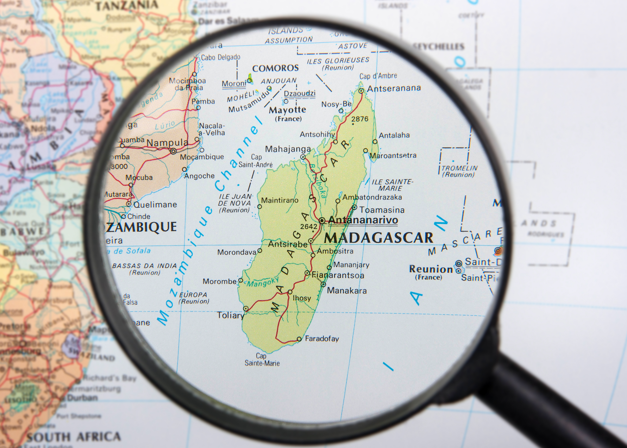
It is day four of our holiday, with two days driving up from Vancouver to Cache Creek, past the Eocene insect and plant site at McAbee, the well-bedded Permian limestone near Marble Canyon and onto Bowron Provincial Park, a geologic gem near the gold rush town of Barkerville. 

The initial draw for me, given that collecting in a provincial park is forbidden and all collecting close at hand outside the park appears to amount to a handful of crushed crinoid bits and a few conodonts, was the gorgeous natural scenery and a broad range of species extant. 

It was also the proposition of padding the Bowron Canoe Circuit, a 149,207-hectare geologic wonderland, where a fortuitous combination of plate tectonics and glacial erosion have carved an unusual 116-kilometre near-continuous rectangular circuit of lakes, streams and rivers bound on all sides by snowcapped mountains. 

From all descriptions, something like heaven. 

The east and south sides of the route are bound by the imposing white peaks of the Cariboo Mountains, the northern boundary of the Interior wet belt, rising up across the Rocky Mountain Trench, and the Isaac Formation, the oldest of seven formations that make up the Cariboo Group (Struik, 1988). 

Some 270 million-plus years ago, had one wanted to buy waterfront property in what is now British Columbia, you’d be looking somewhere between Prince George and the Alberta border. The rest of the province had yet to arrive but would be made up of over twenty major terranes from around the Pacific. 

The rock that would eventually become the Cariboo Mountains and form the lakes and valleys of Bowron was far out in the Pacific Ocean, down near the equator. 

With tectonic shifting, these rocks drifted north-eastward, riding their continental plate, until they collided with and joined the Cordillera in what is now British Columbia. Continued pressure and volcanic activity helped create the tremendous slopes of the Cariboo Range we see today with repeated bouts of glaciation during the Pleistocene carving their final shape. 

We brace our way into a headwind along the east side of the fjord-like Isaac Lake. Paddling in time to the wind, I soak up the view of this vast, deep green, ocean-like expanse that runs L-shape for nearly 38 kilometres, forming nearly half of the total circuit. 

The rock we paddle past is primarily calcareous phyllite, limestone and quartzite, typical of the type locality for this group and considered upper Proterozoic (Young, 1969), the time in our geologic history between the first algae and the first multicellular animals.

It is striking how much this lake fits exactly how you might picture pristine wilderness paddling in your mind’s eye. No powerboats, no city hum, just pure silence, broken only by the sound of my paddle pulling through the water and the occasional burst of glee from one of the park’s many songbirds. 

We have chosen kayaks over the more-popular canoes for this journey, as I got to experience my first taste of the handling capabilities of a canoe last year in Valhalla Provincial Park. The raised sides acted like sails and kept us off course in all but the lightest conditions. 

This year, Philip Torrens, Leanne Sylvest, and I were making our trek in low profile, Kevlar style. 

One single & one double kayak would be our faithful companions and mode of transport. They would also be briefly conscripted into service as a bear shield later in the trip. Versatile those kayaks. 

The area is home to a variety of plant life. Large sections of the forest floor are carpeted in the green and white of dogwood, a prolific ground cover we are lucky enough to see in full bloom. Moss, mushrooms and small wild grown on every available surface. 

Yellow Lilies line pathways and float in the cold, clear lake water. Somewhere I read a suggestion to bring a bathing suit to the park, but at the moment, I cannot imagine lowering anything more than my paddle into these icy waters. To reach the west side of the paddling route, we must first face several kilometres portaging muddy trails to meet up with the Isaac River and then paddle rapids to grade two. 

At the launch site, we meet up with two fellow kayakers, Adele and Mary of Victoria, and take advantage of their preceding us to watch the path they choose through the rapids. It has been raining in the area for forty plus days, so the water they run is high and fast. Hot on their heels, our short, thrilling ride along the Isaac River, is a flurry of paddle spray and playing around amid all the stumps, silt and conglomerate. 

The accommodation gods smile kindly on us as we are pushed out from Isaac River and settle into McLeary Lake. An old trapper cabin built by local Freddie Becker back in the 1930s, sits vacant and inviting, providing a welcome place to hang our hats and dry out. 

From here we can see several moose, large, lumbering, peaceful animals, the largest members of the deer family, feeding on the grass-like sedge on the far shore. 

The next morning, we paddle leisurely down the slower, silt-laden Cariboo River, avoiding the occasional deadhead, and make our way into the milky, glacier-fed Lanezi Lake. Like most mountainous areas, Bowron makes its own weather system and it appears you get everything in a 24-hour period. 

In fact, whatever weather you are enjoying seems to change 40 minutes later; good for rain, bad for sun. Wisps of cloud that seemed light and airy only hours early have become dark. Careful to hug the shore, we are ready for a quick escape from lightning as thundershowers break. 

Paddling in the rain, I notice bits of mica in the water, playing in the light and the rock change here to greywacke, argillite, phyllite and schist. Past Lanezi, we continue onto Sandy Lake, where old-growth cedars line the south-facing slopes to our left and grey limestone, shale and dolostone line the shore. Mottled in with the rock, we sneak up on very convincing stumps posing as large mammals. 

Picking up the Cariboo River again, we follow it as it flows into Babcock Lake, an area edged with Lower Cambrian limestone, shale and argillite. At the time these rocks were laid down, the Earth was seeing our earliest relatives, the first chordates entering the geologic scene. 

Mamma Moose, Baby Moose... Grizzly!
As we reach the end of Babcock Lake and prepare for our next portage I get out my camera to take advantage of the angle of the sun and the eroded rounded hilltops of the Quesnel Highlands that stand as a backdrop.

Leanne remarks that she can see a moose a little ways off and that it appeared to be heading our way. 

Yes, heading our way quickly with her calf in tow. I lift my lens to immortalize the moment and we three realized they were headed our way in double time because they were being chased by a grizzly bear — at top speed. 

A full-grown moose can run up to fifty-five kilometres per hour, more or less neck and neck with the speed of a Grizzly. They are also strong swimmers. Had she been alone, Mamma moose would likely have tried to outswim the bear. 

From where we stand we can see the water turned to white foam at their feet as they fly towards us. 

We freeze bear spray in hand. 

In seconds the three were upon us. Mamma moose, using home-field advantage, runs straight for us and just reaching our boats, turned 90 degrees, bolting for the woods, baby moose fast on her heels. 

The Grizzly, caught up in the froth of running and thrill of the kill, doesn’t notice the deke, hits the brakes at the boats and stands up, confused. Her eyes give her away. 

This was not what she had planned and the whole moose-suddenly-transformed-into-human thing is giving her pause. Her head tilts back as she gets a good smell of us. 

Suddenly, a crack in the woods catches her attention. Her head snaps around and she drops back on all fours, beginning her chase anew. Somewhere there is a terrified mother moose and calf hoping the distance gained is enough to keep them from being lunch. Both moose got away with the unwitting distraction we provided. 

The Lakes are at an elevation of over 900 m (3000 ft) and both grizzly and black bear sightings are common. Both bear families descend from a common ancestor, Ursavus, a bear-dog the size of a raccoon who lived more than 20 million years ago. Seems an implausible lineage having just met one of the larger descendants.

While we had grumbled only hours earlier about how tired we were feeling, we now feel quite motivated and do the next two portages and lakes in good time. Aside from the gripping fear that another bear encounter is imminent, we enjoy the park-like setting, careful to scan the stands of birch trees for dark shapes now posing as stumps. Fortunately, the only wildlife we see are a few wily chipmunks, various reticent warblers and some equally shy spruce grouse. 

The wind favours us now as we paddle Skoi and Spectacle Lake, even giving us a chance to use the sails we’ve rigged to add an extra knot of oomph to our efforts. Reaching the golden land of safety-in-numbers, we leap from our kayaks, happy to see the smiling faces of Mary and Adele. Making it here is doubly thrilling because it means I’m sleeping indoors tonight and I can tell the bear story with adrenaline still pumping through my veins. Tonight is all about camaraderie and the warmth of a campfire. 

Gobbling down Philip’s famous pizza, Leanne impresses everyone further by telling of his adventures in the arctic and surviving a polar bear attack. This is our first starlit night without rain, a luxury everyone comments on, but quietly, not wanting to jinx it. We share a good laugh at the expense of the local common loons — both Homeo sapien sapien and Gavia immer

Common Loon / Gavia immer
The marshy areas of the circuit provide a wonderful habitat for the regions many birds including a host of sleek, almost regal black and white common loons. 

Their cool demeanour by day is reduced to surprisingly loud, maniacal hoots and yelps with undignified flapping and flailing by night. 

It seems hardly possible that these awful noises could be coming from the same birds and that this has been going for nearly 65 million years, since the end of the age of dinosaurs, as loons are one of the oldest bird families in the fossil record. 

A guitar is pulled out to liven the quiet night while small offerings, sacred and scare this late in our journey, are passed around. Tonight is a celebration that we have all, both separately and together, made our way around this immense mountain-edged circuit.

Know before you go

BC Parks Bowron Lake Circuit Link: https://bcparks.ca/reserve/bowron-lake/

  • Reservations may be booked up to 2 days prior to the departure date.
  • All canoe circuit users must attend a mandatory orientation session (9:00 am or 12:00 noon) and visitors must report to the registration centre by the specified time.
  • Visitors who have not attended their mandatory orientation session are considered no-shows. No-shows’ reservations will be given to first-come, first-served visitors. No refunds are granted for no-shows.
  • Bowron Lake canoe circuit paddlers are responsible for bringing or renting their own equipment (personal flotation devices, paddles, vessels etc). Reservation transactions only include your reservation charges and user (camping) fees and do not include equipment rental. Visitors must familiarize themselves with the mandatory equipment required to paddle the circuit.
  • Reservations are not transferable. Any reservation owners or holders found to be transferring or selling their reservations to another party, risk the chance that their reservation may be cancelled without a refund. If a customer can no longer use their reservation, they are encouraged to cancel their reservation so that any unused User Fees that are not forfeited as a penalty, can be automatically refunded to the credit card that was used to make the original reservation. Only the person whose name is on the reservation has access to change or cancel a reservation.
  • At least one of the reservation holders ("Occupant" or "Optional Authorized Person") must be present upon arrival and during the stay. Identification may be required to keep the reservation valid.
  • Reservations for the Bowron Lake canoe circuit are based on a non-refundable per vessel charge of $18.00 (plus tax) in addition to user fees ($60.00 per person for the full canoe circuit and $30.00 per person for the West Side). There is a limit of three (3) people per vessel.
  • Accepted payment types include Visa, Mastercard, American Express, Visa Debit, and Mastercard Debit.
  • Changes to a reservation can be made for a charge of $6.00 (plus tax), provided that space is available. No changes are permitted 28 days or less before the departure date.
  • Cancellations are subject to a $6.00 (plus tax) per cancellation charge.
  • Refunds – If a trip is cancelled more than 28 days before the departure date, customers receive a full refund less cancellation and non-refundable reservation charges. If cancellations are made with 28 or less days notice, no refunds apply. Transaction (reservation, change, cancellation) charges are non-refundable.
  • Visitors who have not attended the mandatory orientation session they registered for are considered no-shows. No-shows' reservations will be given to first-come, first-served visitors. No refunds are granted for no-shows.

Friday 24 February 2023

SHUSWAP NATION FOSSIL BEDS

The McAbee Fossil Beds are known for their incredible abundance, diversity and quality of fossils including lovely plant, insect and fish species that lived in an old lake bed setting 52-53 million years ago.

It is one of the best local sites in the province to experience a fossil dig first-hand. It's an easy 4-hour drive from Vancouver and easily done as a rather longish day trip. I headed up this past summer with some wonderful enthusiastic crew to see how things were progressing with its development.

The site was designated a Provincial Heritage Site under British Columbia's Heritage Conservation Act in July of 2012. The site was reopened to public tours and viewing this summer with plans to build out a visitor's centre and educational programs in the future.

We were greeted on the day by two wonderful hosts from the Bonaparte Band, Gayle Pierro and Leroy Antoine. Both were very welcoming and informative, sharing the lay of the land, a bit of their history with the workings and offering us a guided tour. 

From the road, it is a short drive up to the first staging area that houses visitor parking and a public washroom. The first Site Information station is a short stroll away and includes a tent with a table and maps showing plans for the site. Here, Gayle walked us through the vision for McAbee and showed us a selection of some of the species found here. 

We were asked to stop back on the way down and fill out a survey that asked about our experience and provide feedback that will help shape what McAbee is to become. A short hike up the hill towards the hoodoos leads to another staging area. Here, Leroy was our host and guide. He shared a bit more about the geology of the area and showed us specimens found over the summer.

As McAbee is a Heritage Site, their only request was that we stay within the marked area and trails and keep ourselves safe. Here safe means hydrated, shaded from the sun and avoiding both the resident rattlesnakes and cacti. McAbee offers an excellent opportunity for education and outreach both for locals and the larger community. It was very enjoyable to see the reactions of those visiting the site as they took in the wonderful diversity of fossil species and learning about the local history from our hosts.

The Province is committed to providing access to the site to scientists and the lay public. The direction on what happens next at McAbee is being driven by the Heritage Branch in consultation with members of the Shuswap Nation and Bonaparte Band. Bonaparte's traditional territory is located within the Shuswap Nation and includes the site where the McAbee Fossil Beds are situated. 

Local members of the Bonaparte Band are Secwepemc. They would like to share the spiritual significance of the area from a Secwepemc First Nation perspective and see McAbee as an indigenous tourism destination. So it looks like it will be paleontology, archaeology with a cultural focus to add spice. In any case, fossil viewing, and hopefully supervised collecting will continue with oversight to ensure significant fossil finds make their way to science.

It would be good to see McAbee take a page out of the Courtney and District Museum's playbook. You'll recall that it was the Puntledge Elasmosaur that sparked the expansion of that museum and inspired a whole host of outreach and educational programs. The Courtenay Museum has been offering paid guided tours to the elasmosaur heritage site for over a dozen years. 

They are members of the British Columbia Paleontological Alliance (BCPA), a union of professional and amateur paleontological organizations working to advance the science of paleontology in the province by fostering public awareness, scientific collecting and education, and by promoting communication among all those interested in fossils. Within that context, the Courtenay Museum are bound both by the BCPA constitution and bylaws, and of course, the laws around fossil collecting in British Columbia.

One of the sister sites to McAbee, the Driftwood Canyon Provincial Park Fossil Beds, offers an honours system for their site. Visitors may handle and view fossils but are asked to not take them home. Both Driftwood Canyon and McAbee are part of an arc of Eocene lakebed sites that extend from Smithers in the north, down to the fossil site of Republic Washington, in the south. The grouping includes the fossil sites of Driftwood Canyon, Quilchena, Allenby, Tranquille, McAbee, Princeton and Republic. Each of these localities provides important clues to our ancient climate.

The fossils range in age from Early to Middle Eocene. McAbee had a more temperate climate, slightly cooler and wetter than other Eocene sites to the south at Princeton, British Columbia, Republic in north-central Washington, in the Swauk Formation near Skykomish and the Chuckanut Formation of northern Washington state. The McAbee fossil beds consist of 30 metres of fossiliferous shale in the Eocene Kamloops Group.

The fossils are preserved here as impressions and carbonaceous films. We see gymnosperm (16 species); a variety of conifers (14 species to my knowledge); two species of ginkgo, a large variety of angiosperm (67 species); a variety of insects and fish remains, the rare feather and a boatload of mashed deciduous material. Nuts and cupules are also found from the dicotyledonous Fagus and Ulmus and members of the Betulaceae, including Betula and Alnus.

We see many species that look very similar to those growing in the Pacific Northwest today. Specifically, cypress, dawn redwood, fir, spruce, pine, larch, hemlock, alder, birch, dogwood, beech, sassafras, cottonwood, maple, elm and grape. If we look at the pollen data, we see over a hundred highly probable species from the site. Though rare, McAbee has also produced spiders, birds (and lovely individual feathers) along with multiple specimens of the freshwater crayfish, Aenigmastacus crandalli.

For insects, we see dragonflies, damselflies, cockroaches, termites, earwigs, aphids, leafhoppers, spittlebugs, lacewings, a variety of beetles, gnats, ants, hornets, stick insects, water striders, weevils, wasps and March flies. The insects are particularly well-preserved. Missing are the tropical Sabal (palm), seen at Princeton and the impressive Ensete (banana) and Zamiaceae (cycad) found at Eocene sites in Republic and Chuckanut, Washington.

McAbee is located just east of Cache Creek, just north of and visible from Highway 1/97. 14.5 km to be exact and exactly the distance you need to drink one large coffee and then need a washroom. You'll be pleased to know they have installed one at the site. McAbee is a site for hiking boots, hand, head and eye protection. They have a few resident rattlesnakes and prickly cacti to keep you on your toes. Keep yourself safe and well-hydrated. There will be someone to greet you and let you know if it is open to collecting or if you'll have to satisfy yourself by enjoying their interpretive offerings.

As you drive up, you'll see telltale hoodoos on the ridge to let you know you've reached the right spot. If you have a GPS, pop in these coordinates and you're on your way. 50°47.831′N 121°8.469′W.

Thursday 23 February 2023

14TH BC PALAEONTOLOGICAL SYMPOSIUM

You will be delighted to know that it is time for the next BCPA Symposium, June 9th - 12th, 2023. 

This is the 14th BC Palaeontological Symposium and it will be hosted by the Victoria Palaeontology Society along with the School of Earth and Ocean Sciences (SEOS), University of Victoria (UVic); Royal British Columbia Museum (RBCM); and, BC Fossil Management Office.

The 2023 BCPA conference is being held at the Bob Wright Centre, University of Victoria, Victoria, BC. I'll post a wee map here to make finding all this goodness a wee bit easier. The Bob Wright Centre (BWC) is just a short walk from Bento Sushi and SciCafé near UVic Parking Lot B.

Keynote Speakers: Dr. Jean-Bernard Caron & Dr. Charles Helm

The Burgess Shale Fossil Deposit of Marble Canyon in Kootenay National Park: Retrospective of the Last 10 Years of Research. In Southeastern BC, the Burgess Shale is the internationally renowned site that keeps on giving.  Symposium 2023 welcomes you on a journey through the past decade, featuring the field research and expertise of:

Dr. Jean-Bernard Caron, Richard M. Ivey Curator of Invertebrate Palaeontology at the Royal Ontario Museum, Toronto.

Dr. Caron leads regular fieldwork activities to the Canadian Rockies primarily to study how the Burgess Shale biota changed through space and time in response to ecological, evolutionary and environmental factors. Field-based research is an important aspect of his work and his research lab primarily focuses on fossilization processes, ecology, phylogeny, and diversity of Burgess Shale animals.

Tracking vertebrates from two eras on two continents—Northern BC is home to our second keynote speaker, Dr. Charles Helm, who is trekking two continents in search of tracks. 

Dr. Charles Helm, Research Associate at the Tumbler Ridge Museum and at the African Centre for Coastal Palaeoscience, Nelson Mandela University, South Africa is currently pursuing his PhD in paleontology in the Department of Geoscience, Nelson Mandela University, South Africa.

His paleontological research interests are in Pleistocene vertebrate tracks in South Africa (including hominin tracks and traces) and Cretaceous vertebrate tracks in northern British Columbia.  

Many of you will know Dr. Helm as founder of the Tumbler Ridge Museum Foundation in 2002. He developed the proposal that led to the creation of the Tumbler Ridge UNESCO Global Geopark in 2014, and was its first President.

BCPA Conference Link: https://vicpalaeo.org/.../14th-bc-palaeontological.../...
BCPA Website: www.bcfossils.ca

Here is a handy dandy map for easy reference:


Tuesday 21 February 2023

NOOTKA FOSSIL AND FIRST NATIONS HISTORY

Nootka Fossil Field Trip. Photo: John Fam
The rugged west coast of Vancouver Island offers spectacular views of a wild British Columbia. Here the seas heave along the shores slowly eroding the magnificent deposits that often contain fossils. 

Just off the shores of Vancouver Island, east of Gold River and south of Tahsis is the picturesque and remote Nootka Island.

This is the land of the proud and thriving Nuu-chah-nulth First Nations who have lived here always

Always is a long time, but we know from oral history and archaeological evidence that the Mowachaht and Muchalaht peoples lived here, along with many others, for many thousands of years — a time span much like always

While we know this area as Nootka Sound and the land we explore for fossils as Nootka Island, these names stem from a wee misunderstanding. 

Just four years after the 1774 visit by Spanish explorer Juan Pérez — and only a year before the Spanish established a military and fur trading post on the site of Yuquot — the Nuu-chah-nulth met the Englishman, James Cook.  

Captain Cook sailed to the village of Yuquot just west of Vancouver Island to a very warm welcome. He and his crew stayed on for a month of storytelling, trading and ship repairs. Friendly, but not familiar with the local language, he misunderstood the name for both the people and land to be Nootka. In actual fact, Nootka means, go around, go around

Two hundred years later, in 1978, the Nuu-chah-nulth chose the collective term Nuu-chah-nulth — nuučaan̓uł, meaning all along the mountains and sea or along the outside (of Vancouver Island) — to describe themselves. 

It is a term now used to describe several First Nations people living along western Vancouver Island, British Columbia. 

It is similar in a way to the use of the United Kingdom to refer to the lands of England, Scotland and Wales — though using United Kingdom-ers would be odd. Bless the Nuu-chah-nulth for their grace in choosing this collective name.  

An older term for this group of peoples was Aht, which means people in their language and is a component in all the names of their subgroups, and of some locations — Yuquot, Mowachaht, Kyuquot, Opitsaht. While collectively, they are the Nuu-chah-nulth, be interested in their more regional name should you meet them. 

But why does it matter? If you have ever mistakenly referred to someone from New Zealand as an Aussie or someone from Scotland as English, you have likely been schooled by an immediate — sometimes forceful, sometimes gracious — correction of your ways. The best answer to why it matters is because it matters.

Each of the subgroups of the Nuu-chah-nulth viewed their lands and seasonal migration within them (though not outside of them) from a viewpoint of inside and outside. Kla'a or outside is the term for their coastal environment and hilstis for their inside or inland environment.

It is to their kla'a that I was most keen to explore. Here, the lovely Late Eocene and Early Miocene exposures offer up fossil crab, mostly the species Raninid, along with fossil gastropods, bivalves, pine cones and spectacularly — a singular seed pod. These wonderfully preserved specimens are found in concretion along the foreshore where time and tide erode them out each year.

Five years after Spanish explorer Juan Pérez's first visit, the Spanish built and maintained a military post at Yuquot where they tore down the local houses to build their own structures and set up what would become a significant fur trade port for the Northwest Coast — with the local Chief Maquinna's blessing and his warriors acting as middlemen to other First Nations. 

Following reports of Cook's exploration British traders began to use the harbour of Nootka (Friendly Cove) as a base for a promising trade with China in sea-otter pelts but became embroiled with the Spanish who claimed (albeit erroneously) sovereignty over the Pacific Ocean. 

Dan Bowen searching an outcrop. Photo: John Fam
The ensuing Nootka Incident of 1790 nearly led to war between Britain and Spain (over lands neither could actually claim) but talk of war settled and the dispute was settled diplomatically. 

George Vancouver on his subsequent exploration in 1792 circumnavigated the island and charted much of the coastline. His meeting with the Spanish captain Bodega y Quadra at Nootka was friendly but did not accomplish the expected formal ceding of land by the Spanish to the British. 

It resulted however in his vain naming the island "Vancouver and Quadra." The Spanish captain's name was later dropped and given to the island on the east side of Discovery Strait. Again, another vain and unearned title that persists to this day.

Early settlement of the island was carried out mainly under the sponsorship of the Hudson's Bay Company whose lease from the Crown amounted to 7 shillings per year — that's roughly equal to £100.00 or $174 CDN today. Victoria, the capital of British Columbia, was founded in 1843 as Fort Victoria on the southern end of Vancouver Island by the Hudson's Bay Company's Chief Factor, Sir James Douglas. 

With Douglas's help, the Hudson's Bay Company established Fort Rupert on the north end of Vancouver Island in 1849. Both became centres of fur trade and trade between First Nations and solidified the Hudson's Bay Company's trading monopoly in the Pacific Northwest.

The settlement of Fort Victoria on the southern tip of Vancouver Island — handily south of the 49th parallel — greatly aided British negotiators to retain all of the islands when a line was finally set to mark the northern boundary of the United States with the signing of the Oregon Boundary Treaty of 1846. Vancouver Island became a separate British colony in 1858. British Columbia, exclusive of the island, was made a colony in 1858 and in 1866 the two colonies were joined into one — becoming a province of Canada in 1871 with Victoria as the capital.

Dan Bowen, Chair of the Vancouver Island Palaeontological Society (VIPS) did a truly splendid talk on the Fossils of Nootka Sound. With his permission, I have uploaded the talk to the ARCHEA YouTube Channel for all to enjoy. Do take a boo, he is a great presenter. Dan also graciously provided the photos you see here. The last of the photos you see here is from the August 2021 Nootka Fossil Field Trip. Photo: John Fam, Vice-Chair, Vancouver Paleontological Society (VanPS).

Know Before You Go — Nootka Trail

The Nootka Trail passes through the traditional lands of the Mowachaht/Muchalat First Nations who have lived here since always. They share this area with humpback and Gray whales, orcas, seals, sea lions, black bears, wolves, cougars, eagles, ravens, sea birds, river otters, insects and the many colourful intertidal creatures that you'll want to photograph.

This is a remote West Coast wilderness experience. Getting to Nootka Island requires some planning as you'll need to take a seaplane or water taxi to reach the trailhead. The trail takes 4-8 days to cover the 37 km year-round hike. The peak season is July to September. Permits are not required for the hike. 

Access via: Air Nootka floatplane, water taxi, or MV Uchuck III

  • Dan Bowen, VIPS on the Fossils of Nootka: https://youtu.be/rsewBFztxSY
  • https://www.thecanadianencyclopedia.ca/en/article/sir-james-douglas
  • file:///C:/Users/tosca/Downloads/186162-Article%20Text-199217-1-10-20151106.pdf
  • Nootka Trip Planning: https://mbguiding.ca/nootka-trail-nootka-island/#overview


Monday 20 February 2023

UNESCOCERATOPS KOPPELHUSAE BY JULIUS CSOTONYI

Unescoceratops koppelhusae, Julius Csotonyi
A very sweet small leptoceratopsid dinosaur, Unescoceratops koppelhusae — a new species in the collections of the Royal Tyrrell Museum of Palaeontology in Drumheller, Alberta.

The colourful and beautifully detailed painting you see here is by the very talented Julius Csotonyi who captured the magnificence of form, texture and palette to bring this small leptoceratopsid dinosaur to life.

The Royal Tyrrell Museum of Palaeontology, named in honour of Joseph Burr Tyrrell, is a palaeontology museum and research facility in Drumheller, Alberta, Canada. 

This jaw is the holotype specimen of this small leptoceratopsid dinosaur. Only a handful of isolated fossils have been found from this species, including a jaw that is the holotype specimen now in collections at the Royal Tyrell. 

The Royal Tyrrell Museum of Palaeontology, named in honour of Joseph Burr Tyrrell, is a palaeontology museum and research facility in Drumheller, Alberta, Canada. 

Unescoceratops koppelhusae, RTMP Collections
The rusty chocolate jaw bone you see here is the puzzle piece that helped all of the research come together and help us to better understand more about the diminutive leptoceratopsid dinosaurs from Alberta. 

The Cleveland Museum of Natural History's Michael Ryan and David Evans of the Royal Ontario Museum in Toronto recently determined that the specimen was a new genus and species. 

Unescoceratops is a genus of leptoceratopsid ceratopsian dinosaurs known from the Late Cretaceous (about 76.5-75 million years ago) of Alberta, Canada. Unescoceratops is thought to have been between one and two meters long and less than 91 kilograms. A plant-eater, its teeth were the roundest of all Leptocertopsids.

Dinosaur Provincial Park, Alberta, Canada
The genus name acknowledges the UNESCO  World Heritage Site, Dinosaur Provincial Park, where the fossil was found. 

In addition to its particularly beautiful scenery, Dinosaur Provincial Park – located at the heart of the province of Alberta's badlands – is unmatched in terms of the number and variety of high-quality specimens.

To date, they represent more than 44 species, 34 genera and 10 families of dinosaurs, dating back 75-77 million years. This provides us with remarkable insight into life millions of years ago.

The park contains exceptional riparian habitat features as well as badlands of outstanding aesthetic value.

The creamy honey, beige and rust coloured hills around the fossil locality are outstanding examples of major geological processes and fluvial erosion patterns in semi-arid steppes — think glorious! 

The scenic badlands stretch along 26 kilometres of high quality and virtually undisturbed riparian habitat, presenting a landscape of stark but exceptional natural beauty.

The species name honours Dr. Eva Koppelhus, who has made significant contributions to vertebrate palaeontology and palynology. 

The genus is named to honour the UNESCO World Heritage Site designation for the locality where the specimen was found and from the Greek “ceratops,” which means 'horned face'. 

Dr Michael Ryan explained that he meant to honour UNESCO's efforts to increase understanding of natural history sites around the world.

© Julius T. Csotonyi An illustration of Unescoceratops koppelhusae, a plant-eating dinosaur from the Late Cretaceous period that lived approximately 75 million years ago shared with his gracious permission. 

ABOUT THE ARTIST

Dr. Julius Csotonyi is a Vancouver-based scientific illustrator and natural history fine artist. He is a featured paleoartist on Season One and Season Two of BC's Fossil Bounty. Julius has a scientific background in ecology (MSc) and microbiology (PhD) which has taken him to study sensitive ecosystems, from sand dunes in the Rocky Mountain parks to hydrothermal vents at the bottom of the Pacific Ocean. 

These experiences have fuelled his strong resolve to work toward preserving our Earth’s biota. Painting biological subjects is one means that he uses to both enhance public awareness of biological diversity and to motivate concern for its welfare.   

He paints murals and panels that have appeared in numerous museums including the Smithsonian’s National Museum of Natural History, press release images for scientific publications, books, stamp sets — including the outstanding 2018 “Sharks of Canada” set for Canada Post — and coins for the Royal Canadian Mint. To view more of Julius Csotonyi's exquisite work visit: https://csotonyi.com/