Tuesday, 30 December 2014

HAIDA GWAII: ISLANDS OF MIST

Steeped in mist and mythology, the islands of the Queen Charlottes abound in local lore that surrounds their beginnings.

Today, the Hecate Strait is a tempestuous 40-mile wide channel that separates the mist-shrouded archipelago of Haida Gwaii from the BC mainland. Haida oral tradition tells of a time when the strait was mostly dry, dotted here and there with lakes. During the last ice age, glaciers locked up so much water that the sea level was hundreds of feet lower than it is today. Soil samples from the sea floor contain wood, pollen, and other terrestrial plant materials that tell of a tundra-like environment.

The court is still out on whether or not the strait was ever completely dry during these times, but it certainly contained a series of stepping-stone islands and bridges that remained free of ice.

An ancient Haida tale, recorded in the late 1800s by a Hudson’s Bay Company trader, records the island's glacial history. Scannah-gan-nuncus, a boy who lived in the village now called Skidegate, had canoed up the Hunnah, a once roaring tributary to Skidegate Channel that is now a rocky creek, seldom deep enough to navigate.

The Haida the legend accurately records that it used to be several times deeper. Tired from paddling upstream, Scannah-gan-nuncus landed to take a nap. “In those days at the place where he went ashore were large boulders in the bed of the stream, while on both sides of the river were many trees. While resting by the river, he heard a dreadful noise upstream. Looking to see what it was, he was surprised to behold all the stones in the river coming toward him. … all the trees were cracking and groaning … he went to see what was crushing the stones and breaking the trees. On reaching them, he found that a large body of ice was coming down, pushing everything before it.”

Scannah-gan-nuncus’ experience with the glacier would have been familiar to the inhabitants of the Queen Charlottes. In recent years, the highest peaks are often bare of vegetation and snow-covered during most of the year, but back in the time of the glaciers, these same local mountains were the birthplace of advancing ice.

Precipitation and a significant drop in temperature gave rise to the Queen Charlottes ice-sheet, a thick mass of flowing ice that ran tandem with the Cordilleran sheet in the Hecate Lowlands.

Strolling around you can see where the glaciers left their mark on the Islands’ U-shape valleys, once a steep V-shape, now scoured smooth by glaciers that also deposited the erratic boulders can been seen sitting like sentinels on the beach.

CRETACEOUS NANAIMO GROUP

The strata near Nanaimo and much of eastern Vancouver Island is underlain by sedimentary rocks of the Cretaceous Nanaimo Group. These mudstones, sandstones and conglomerates were deposited in deltas, rivers and marine environments between 95 and 65 million years ago. While there is a mix, almost all of the great fossil exposures are marine.

Monday, 29 December 2014

CAMBRIAN TRILOBITES


The Cambrian was a time of expansion for the Earth's complex animal forms. Molluscs and arthropods and their friends with hard shells and exoskeletons dominated the seas. The specimen you see here is of a Wanneria dunnae trilobite from the Eager Formation, Rifle Range site near Cranbrook, British Columbia.

Thursday, 25 December 2014

Wednesday, 17 December 2014

Monday, 17 November 2014

Wednesday, 12 November 2014

Tuesday, 23 September 2014

TRACKING THEROPODS

Toe to Toe with a Theropod — In the outcrops around Clarens, South Africa.

We get a bird's eye view (or Theropod's eye view) of life back in the Late Triassic and Early Jurassic. Both here and at Elliott we see dinosaur remains tracks and dino eggs!

Thursday, 18 September 2014

PETRIFIED WOOD

Petrified wood is amazing to behold in person. The original tree or branch is sometimes subjected to such a high degree of replacement that it is impossible to tell from the original at first glance. But fossilized it is. All of the original cells are replaced one by one with minerals, often a silicate such as quartz, leaving the original cell structure intact.


And while there is often amazing preservation of the big woody bits, the telltale leaves that help us identify that wood to species are often lost. If this is the case, we add our best guess at the genus and add xlon. So, Palmoxylon is the indeterminate wood of a palm, though we may never know which palm. If you have an interest in botany and fossils, you may want to consider making a career of it. The study of fossil wood is called palaeoxylology. And a palaeoxylologist is someone who studies fossil wood.

Thursday, 21 August 2014

Wednesday, 30 July 2014

TLINGIT: SIXTEEN QWAAN

Coastal Alaska is spectacular, if rain-drenched, with rugged mountains and fjords. 

An archipelago of islands, 80 miles wide and scraped up by continental plates, protects the mainland shore. 

Covered by forests of spruce, hemlock, cedar, and brush, these lands were home to marten, beaver, mink, deer, bear, Dall sheep, and mountain goat, while the sea teemed with seal, sea otter, and many kinds of fish, particularly salmon and halibut.

In the First Nations mythology of Alaska and Siberia, the present world owes much of its form and features to an immortal being called Raven, who combined attributes of spirit, human, bird, genius, and fool. 

A god often known as Heaven had a diffuse and distant interest in the world. Among Tlingit, this being is called Shagoon, with a complex meaning that includes ancestors, heritage, origin, destiny, and supreme deity.

Chilkat Estuary
Throughout the North Pacific Coast, except at the far north, red cedar trees provided natives with logs for posts and moulded canoes, or straight-grained planks for house sides, bentwood boxes, and essential tools. 

Travel was mostly by water because of dense undergrowth, thickets of berries and brambles, obstructed land routes, except along river banks.

In early spring, rivers run with smelt-like candlefish, so named because their bodies were full of oil that was boiled out for use as food. All summer runs of five different salmon species were processed for storage as winter supplies.

Area resources were generally abundant but varied from one local to another. These fluctuations became evened out by towns working together through elaborate kinship networks, social units like houses and clans, and complex international (or intertribal) relations expressed through rituals.

Expanding northward for centuries, the Tlingit nation most recently consists of three language subdialect regions with sixteen individual qwaan or tribes, each with a primary village. 

These are, north to south, the Gulf Coast region with Yakutat and Lituya Bay; the Northern region with Hoonah, Chilcat, Auk, Sitka, Hutsnuwu, Taku, and Sawdum; and the Southern region with Kake, Kuiu, Henya, Klawak, Stikine, Tongass, and Sanya. 

Neighbours to the south were the Tsimshian, to the west were the Haida, and to the east were Athapaskans (who call themselves Dine) of Interior Alaska. Further north was the Eyak, remotely related by language ancestry but adopting Tlingit speech and culture over past centuries.

The basic unit of Tlingit society was the household, a "house" (in the same sense as the House of David or House of Windsor) that was a home with three resident social classes of nobles, commoners, and slaves.

An actual house, the visible form for vital economic, social, political, and religious bonds, was a large rectangle with cedar planks set along the sides and upon a low-sloping, the peaked roof held up by four decorated corner posts and a ridge beam. Inside, the floor was dug down so the sides of the house could hold two or more levels of benches, a platform where people sat and a higher one divided by wooden partitions into sleeping compartments. On the beach in front of the house were canoes, sheds for smoking fish, drying racks, and work areas.

At the rear of each house, before or inside its secluded storeroom holding sacred treasures, lived the members of the nobility who owned that house. Their eldest man was the leader of the household, but his mother and sisters provided the links among all the members. Along the sides lived families of commoners who attached themselves to that house as kin or labor. Beside the oval front door slept slaves, taken in war or the children of such captives, whose lives belonged to their owner, along with all their efforts.

Along the sides of the house where they lived, families kept their own open fires for cooking and heating. In the middle, however, was a large public hearth used to cook meals for the noble owners or for guests attending a celebration.

Houses owned stories (epics, sacred histories) naming the past people, places, and resources used and thus claimed by clan ancestors. Some of these histories reflect regional patterns over two thousand years old, involved with fishing, berrying, seaweeding, and hunting at locales owned by a specific house. Most stories in the Northwest, therefore, are "copyrighted" by households within clans. Only a few are phrased in such general terms that they were widely known and used to teach a moral.

Each house was like a corporation that held a number of these inherited art forms known as "crests", broadly including myths, names, designs, songs, dances, carvings, masks, costumes (see also "Louis Shotridge, Museum Man: A 1918 Visit to the Nass and Skeena Rivers",) and the locations of houses, graves, and camps near food resources such as berries, beaches, seaweeds, shellfish, fish, and game. Sometimes known as "treasures", each one was "purchased" by a death or other drastic payment. In the famous history of Glacier Bay, a careless girl started a glacier moving that destroyed much of her town until her grandmother sacrificed herself. Since then, descendants in their house and clan have used Glacier as a crest concept and image.

Leaders of houses and clans could be wealthy and generous because they had several wives and slaves to process food and luxury goods needed to maintain a healthy community of contented people. Important knowledge was personally or corporately owned in this region, such that the most important information could be "whispered" only to very close kin. Several corporations may appear to have the same epic, but seemingly minor details or variations (featuring a clam, sea urchin, or crab, for example) were sufficient in the native view to make them different properties, if not completely different myths.

For each tribe, its winter towns had a row of big plank houses facing a beach on a sheltered bay. Some towns were surrounded by a wooden palisade for protection, or nobles had a nearby fort where they could flee for safety and defence. In each plank house, several families lived because they were related through women belonging to named houses, clans, and moieties (halves, sides, pairs). Steeped in the symbolism of everything having at least two sides, these halves were never political or cohesive entities. Instead, both provided the highest, most general category for organizing their universe as pairs.

Tlingit moieties were either Raven and other (Wolf, sometimes also called Eagle). Important Raven crests were Raven, Owl, Whale, Sealion, Salmon, Frog, Sun, Moon, and Ocean; while those of the other were Wolf, Eagle, Petrel, Bear, Orca, Shark, Halibut, and Thunderbird. These images could properly appear on backdrops, posts, canoes, feast dishes, ladles, pipes, clothing, blankets, armour, helmets, drums, staffs, rattles, and graves.

Members of clans in one moiety were expected to marry into clans of the other, with children inheriting the clan and side of their mother. All through life and at death, the father's side helped, served as witnesses, and then buried the children of their wives. Brothers, therefore, more than fathers were vital to the raising of children, as sisters were much more closely related than wives.

Tlingit law was based in the moiety, clan, and house so any injury to members on the other side had to be made good by payment of goods, services, or property. To settle major disagreements, particularly after a war, a crest might change hands. If a low-ranking person killed a chief and the criminal could not arrange compensation from his or her clan, then their own chief might be killed to even the score. Sometimes, hostages are known as "deer" were exchanged for eight days as proof of sincere intent to settle differences peacefully. These "deer" rested quietly while all of their needs were anticipated.

A Lifetime

Tlingits regard a person as a series of layers around a core of mind, soul, and inner feelings. The outer body has eight sections, counted by upper and lower limbs (twice two arms and two legs). Each birth was a rebirth, a reincarnation of some relative of the mother, to carry on her house and clan. When a boy was about eight he went to live with his mother's brother to learn how to fulfill responsibilities to their house. He came of age when he hunted and killed his first game animal. A girl came of age at puberty, when her father's sister, representing his house, closely supervised her eight-day seclusion, while her own mother and grandmother taught her house traditions. A girl of high rank was secluded for two years, then ready for an arranged marriage. The birth of each child was celebrated according to family rank. Finally, at death, the opposite moiety took care of the body, wake, and cremation, while the mourners gave full expression to their grief in dirges. Burning the body released the soul to leave the town through the cemetery and forest before climbing a mountain to go to "the other side". A month later, the mourners potlatched their others in gratitude, expecting the widow or widower to remarry into that house or clan after a year. The bodies of slaves and shamans were treated in other ways.

A Tlingit leader could display the deeds of his predecessors or of himself by hiring a carver. He carefully selected some crest designs from those of his elite ancestors to decorate a log (which Henry Schoolcraft first called a "totem pole" using an Ojibwa concept). Examples of this beautiful art were done in what is called the form-line style because a flowing black frame outlines each figure. Such a sculpted pole could serve as a portal into a house, a supporting pillar for the remains of a deceased relative, or a memorial standing on the beach. When it was finished, a huge celebration known as a potlatch, meaning "to give" was held. A crowd of guests helped to set up the pole and then were fed and entertained with food and the epics telling about the figures shown on this artwork.

Potlatch

Potlatches were the most distinctive feature of the Northwest, helping to share the local bounty, keep track of the shifting loyalties among commoners, and legalize claims to nobly entitled names. Each one involved a formal display of crests, privileges, members, foods, and resources in the presence of elite witnesses and guests, who accepted meals and gifts in return for supporting these changes in the social fabric. During this feast and elaborate give-away, a noble family dramatized their clan crests via songs, dances, masks, effigies, and natural rarities. Later, guests would host their own potlatches to share what they had with their former hosts.

Throughout the Northwest, each nation held its potlatches at various critical life junctures. Tlingit held three major potlatches for piercing the ears of noble children, for funerals, and for memorials when an heir took the place of his mother's brother (uncle). Tsimshian held them to mark the death of a leader, while Haida celebrated the house dedication of a mature leader and then his death.

During winter, houses hosted potlatches and other events that were primarily religious, bringing together spirits, ancestors, and the living to celebrate changes in the status, ranking, and lives of kin. Side partitions were removed from inside the house, converting it into an amphitheater holding guests from near and far. Since everything had a soul, these ritual gatherings showed them respect and asked their help in feeding, clothing, and healing people.

Doctors

Each house and clan should have the spiritual, medical, and psychological protection of a native specialist technically known as a shaman, or, more usually among natives, as a doctor. Though most were men, a few were women of great powers. Doctors were noted for curing, healing, controlling weather, bringing luck to a hunt or battle, predicting the future, learning news from far away, exposing witches, and speaking with the dead. At his own death, his spirit powers went to a younger relative, who became dizzy and ill until he or she accepted this burden. To be acceptable to receive this help, both novice and shaman had to be pure through fasting, thirsting, purging, and chastity. Shamans let their hair grow to keep their powers strong, but officers of the US Navy who opposed them once punished them by shaving their heads.

Misunderstandings

Unfortunately, officials in the United States and Canada outlawed the potlatch because they did not understand how people could spend years saving up only to then give everything away. In Canada, pressure from Indian Agents, missionaries, and zealous native converts forbid both potlatching and spirit dancing between 1884-1951. Theories of the potlatch have seen it as an elaborate game, as a banking system with doubling interest payments, and as a historical extravagance fueled by fur trade goods, but no one answer can explain this complex event.

Much has happened to native peoples and their traditions. The Northwest Coast was decimated by severe measles, smallpox, and other epidemics. Among these dead were the proper claimants to the limited number of renowned name. After they were gone, commoners took chances to claim titles beyond their former aspirations, amassing property that was used more like bribes than gifts.

After the 1830s, the English Hudson's Bay Company was buying furs with trade goods, so a commoner could work hard to gain property to potlatch and claim a high name. After some villages and tribes gathered around forts and trading posts where, for the first time, they had to meet every day, an extravagant "rivalry potlatch" flared up briefly as a way to sort out the relative positions of these new neighbours as house, clan, and tribal chiefs. While the trading context was not new, these multi-tribal towns were, requiring highly creative solutions for co-existence.

Trade

A vast and ancient trade network linked the Northwest Coast with the interior Athapaskan Subarctic tribes. Certain Tlingit chiefs retained hereditary rights to trade with Athapaskan leaders, marrying their kinswomen to tighten their bond. Each generation, men of particular Tlingit noble houses married Dine women of high degree.

Trade routes went up river valleys (such as the Taku, Stikine, Alsek) and over mountain passes (named Chilkat, Chilcoot). Goods were taken in canoes upriver as far as possible, then switched into male slaves' backpacks made of a large basket with shoulder and forehead straps, holding 100 pounds or more. In large groups, women carried packs weighing about 65 pounds, and saddlebags on dogs held up to 25 pounds. A wise trader always included a shrewd elderly woman to act as a bargainer and to keep track of exchange values.

From the interior came moose hides, fine moccasins, birchwood bows wrapped with porcupine gut, dressed caribou hides, leather thongs and sinews, snowshoes, and copper ore. Brought from the coast were cedar baskets, fish oil, shells, and smoked seafood. More exotic items, like copper and special woods, were traded with the Inuit from Alaska to Siberia, who received dentalia (tusk shell) from Vancouver Island in exchange. Like all activities, trading had religious aspects. Traders had to prepare by fasting, consulting a shaman, and then hosting a feast. Before leaving, he or she applied face paint to look their most attractive.

Tlingit also traded among themselves. For example, to island peoples, men and women from mainland Tlingit villages traded rabbit or marmot skin blankets, moose hide shirts, skin trousers with feet, dressed hides, cranberries in oil, pressed strawberry cakes, candlefish oil, horn spoons, woven blankets, and spruce root baskets. In return, islanders gave sea otter pelts, dried venison, seal oil, dried fish (halibut, salmon, herring), dried seaweed, clams, mussels, sea urchins, herring spawn, cedar bark, baskets, greenstone, and yew wood for bows, boxes, and batons.

Tlingit profits from the interior increased during the fur trade era when everyone inland wanted manufactured goods, such as guns, powder, shot, hardtack, flour, rice, beans, pants, shirts, yard goods, blankets, tobacco, molasses, steel traps, knives, hatchets, needles and thread, paint, and jewellery.

Tlingits never assumed that Europeans were obviously superior. (See also: "Alaskan Wage Earners in the 19th Century".) Instead, they regarded all strangers as fair game. Natives quickly learned to use tea to dye red fox skins to look like more valuable pelts. The fierce international competition encouraged such tricks. When the Russians tried to use dentalia as a kind of money, the Spanish and Americans glutted the market by bringing many of these shells up from California. Tlingits have long had extensive trade with Tsimshians to their south.

Tsimshian

Among those granted religious asylum in Alaska were a thousand Tsimshians, who accompanied their life-long missionary after a heated disagreement with his Anglican bishop at Metlakatla near modern Prince Rupert, British Columbia.

Organized into houses, clans, and four crests divided into Orca-Wolf or Raven-Eagle moieties, all inherited through the mother, Tsimshians controlled the profitable trade in candlefish oil, along with furs and sophisticated artworks, long before the arrival of European ships seeking furs. In time, forts replaced ships as trading places. Then, in 1834, nine Coast Tsimshian villages set up separate neighbourhoods outside the newly built Fort (later Port) Simpson. (See also: "Tsimshian Clan and Society".) In the process, village chiefs appointed heirs to manage these neighbourhoods while the older leaders remained in their Skeena River villages, becoming tribal chiefs since each directed at least two villages. Rankings among these chiefs became contested so they too began to hold "rivalry potlatches" in order to sort out their relative statuses.

Finally, the holder of the titled name of Legex emerged from these contests as the Tsimshian grand chief, dominating the Skeena River fur trade. While the medium of exchange had earlier been lush animal pelts, the Hudson's Bay Company two-point blanket became the new currency. Some especially treasured items such as the "copper" became a repository for vast wealth. A copper was a heraldic shield with different values by tribe and nation. The Tlingit assigned to a copper, which they called Din-ne for its Athapaskan sources, a reasonably stable value of five or six slaves.

Major changes came from introduced religions. For several years after 1800, a series of Athapaskan prophets called Bini ("mind") preached an accommodation of European and traditional beliefs for the Northwest, but these attempts did not last long because in 1857, William Duncan, a Victorian lay missionary, settled among Coast Tsimshians, learned their language, and created a model cooperative Christian community that still exists in Alaska, where they moved in 1887. In hindsight, Duncan's success derived from his replacing the converted Legex as head of most Tsimshians.

Reference: https://content.lib.washington.edu/aipnw/miller1.html

Tlingit: Sh yáa.awudanéiyi a ḵwáan. It means, respect people, respect yourself and other people will respect you.

Tuesday, 29 July 2014

Sunday, 27 July 2014

Tuesday, 22 July 2014

AMMONITES & MARINE REPTILES FROM THE MYSTERIOUS CREEK FORMATION

The Cretaceous-Jurassic exposures near Harrison Lake, British Columbia are an easy two hour drive from Vancouver and another hour or so to our final destination, the unyielding siltstone of the Callovian, 166 million year old, Mysterious Creek Formation.

A few hours of collecting yield multiple bivalves, ammonites, including what looks to be two new species. 

Amongst the best specimens of the day are several small, fairly well preserved Cadoceras (Paracadoceras) tonniense, a few Cadoceras (Pseudocadoceras) grewingki and two relatively complete specimens of the larger, smooth Cadoceras comma. Further up the road, we photograph blocks of buchia and large boulders encrusted with perfectly preserved belemnites from ancient squid.

Interestingly, the ammonites from here are quite similar to the ones found within the lower part of the Chinitna Formation, Alaska and Jurassic Point, Kyuquot, on the west coast of Vancouver Island. The siltstone here at Harrison has also offered up a small section of vertebra from a poorly preserved marine reptile, a find I'm rather keen to make one day. So, after much hammer swinging, I've enjoyed a splendid day, collected beautiful specimens and feel a wee bit closer to the big find. 

Sunday, 13 July 2014

TYLOSTOMA TUMIDUM

This lovely big fellow is Tylostoma tumidum, an epifaunal grazing Lower Cretaceous Gastropod from white, micritic, coarsely nodular limestone deposits of the Goodland Formation at White Settlement west of Fort Worth, Texas, USA. (171.6 to 58.7 Ma). The bedding here is massive with some thin clay beds. The macro fossil found here include the ammonite, Oxytropidoceras acutocarinatum, pelecypods such as Protocardia, Pinna and Lima wacoensis along with heart-shaped urchins in abundance and lovely gastropods such as this beauty, Tylostoma tumidum.

Tylostoma have thick, smooth shells with a moderately elevated spire. Their aperture is ovato-lunate with the lips meeting above at a sharp angle. The outer lip is furnished internally, running the whole length and ending with a thickened edge. This specimen shows the wear and tear of erosion common at the site.

Saturday, 5 July 2014

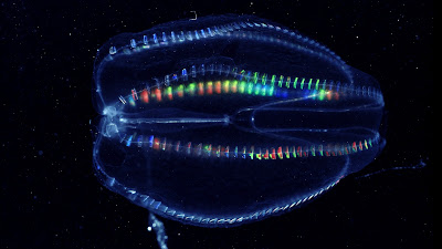
LIVING FOSSIL: COMB JELLY

Living Fossil / Comb Jelly / Ctenophore
This lovely invertebrate is a Comb Jelly, a living fossil. Coined by Charles Darwin, the term “living fossils” is used to describe organisms that have remained largely unchanged for millions of years. While simple in design, the Comb Jellies have stood the test of time. The color you see here is light refracting on rows of Mertensia ovum.

Sunday, 1 June 2014

CANADODUS SUNTOKI: 25-MILLION YEAR OLD FOSSIL FISH FROM SOOKE

A new genus and species of prehistoric fish have been named after a Vancouver Island collector who discovered a well-preserved fossil of the creature in Sooke.

The species named the Canadodus suntoki by Russian researcher Evgeny Popov is named after collector Steve Suntok who donated the fossil to the Royal BC Museum in 2014.

The name roughly translates to “tooth from Canada,” as the fossil is part of a fish dental plate.

Popov, who is one of the world’s leading experts on fossil holocephalian fishes, says that the fossil that Suntok found is an entirely new fish compared to anything found before.

“I knew it was something significant. Not necessarily a new species but something significant,” Suntok told CTV News Thursday.

The fossil dental plate indicates that the fish was likely a type of Chimaeridae, which is a species of fish that feeds on invertebrates by crushing their shells on its hard flat dental plates, before eating the animal inside, according to researchers.

Suntok found the fossil in a northwest portion of Sooke. Researchers say that Sooke is an excellent area for paleontological discoveries, with a variety of fossils at the Royal BC Museum coming from the region.

Ancient whale vertebrae and rib specimens have been found in Sooke and donated to the museum, as well as a potential terrestrial mammal bone, fossil leaves, and many invertebrate fossils, such as oysters, barnacles and snails.

The Suntok family has experience finding and preserving fossils on Vancouver Island. Many fossils discovered by the family have been donated to the Royal BC Museum, including a new waterbird coracoid bone which was named after Steve Suntok’s daughter, Leah, in 2015, named the Stemec suntokum.

“Because of erosion, every time we go there there’s something new,” said Suntok.

“New things get exposed so from time to time I go back just to check out the site. On this occasion, I found something I’d never seen before, which was pretty exciting.”

Researchers say that cliff faces near Muir Creek and beaches near Kirby Creek in Sooke “easily contain the richest exposures of fossils near Victoria.” Fossils in the area tend to date back approximately 25 million years.

Vancouver Island palaeontologist Marji Johns, who is a co-author of research on the Canadodus suntoki, says that she was thrilled by the discovery.

Sooke, British Columbia and Juan de Fuca Strait

Johns says that very few palaeontologists in B.C. and Canada are able to do fieldwork while conducting research and that volunteer collectors like the Suntok family are largely responsible for finding rare and usual fossils..

Suntok says that having the Canadodus suntoki named after him is a dream come true.

“I’m ecstatic about it. It’s the dream of every amateur collector,” he said.

“It’s an honour. I don’t deserve it, but I’m extremely appreciative of it.” 

Reference: 

https://www.iheartradio.ca/580-cfra/it-s-an-honour-newly-discovered-fossil-fish-species-named-after-vancouver-island-collector-1.13515837

Wednesday, 21 May 2014

Saturday, 3 May 2014

ISOGRAPTUS MAXIMUS

This fellow is the graptolite, Isograptus cf. maximus, from the Piranha Formation, Middle Ordovician (Dapingian), Bolivia.

Graptolites (Graptolita) are colonial animals. The biological affinities of the graptolites have always been debatable. Originally regarded as being related to the hydrozoans, graptolites are now considered to be related to the pterobranchs, a rare group of modern marine animals.

The graptolites are now classed as hemichordates (phylum Hemichordata), a primitive group which probably shares a common ancestry with the vertebrates.

In life, many graptolites appear to have been planktonic, drifting freely on the surface of ancient seas or attached to floating seaweed by means of a slender thread. Some forms of graptolite lived attached to the sea-floor by a root-like base. Graptolite fossils are often found in shales and slates. The deceased planktonic graptolites would sink down to and settle on the sea floor, eventually becoming entombed in the sediment and are thus well preserved.

Graptolite fossils are found flattened along the bedding plane of the rocks in which they occur. They vary in shape, but are most commonly dendritic or branching (such as Dictoyonema), saw-blade like, or "tuning fork" shaped (such as Didymograptus murchisoni).

This fellow is pure "Bat Sign" with his showy "wings" looking like something out of a DC Comic. He's also received a nod as the Panem symbol in Hunger Games and been described as having eagle or angel wings. No matter how you interpret his symbolism, there is not doubt that he is spectacular. He is in the collection of the deeply awesome Gilberto Juárez Huarachi from Tarija, Bolivia.

Friday, 14 February 2014

Tuesday, 21 January 2014

Friday, 17 January 2014

SUMAS EOCENE SITE

There was a large downpour that hit Washington State causing massive slides. The blocks you see here all came crashing down on the hillside.

Once the skies cleared, hikers found plant impressions in the rock and alerted the local paleo community. I was invited to tag along on a trip to photograph the site while George Mustoe took moulds of the palm trunks and trackways.

The slide site at Sumas Mountain revealed many large exposures of fossil plants. Some exposures were 10 feet across. There was great excitement at seeing shorebird tracks and trackways of the large flightless bird Diatryma. Many of these finds can now be seen at the Burke Museum in Washington State. While less abundant, evidence of the animals that called this ancient swamp home are also found here. Rare bird, reptile, and mammal tracks have been immortalized in the soft muds along ancient riverways.

Wednesday, 15 January 2014

Monday, 6 January 2014

NORTHWEST BAY, VANCOUVER ISLAND

Northwest Bay is located just south of Parksville on Vancouver Island. It is a lovely place to go for a fossil day trip. Purchase a local map to help with directions. Turn east off the Island Highway onto Northwest Bay Road. Continue for 3 km and then turn left onto Wall Beach Road, which ends in a parking area up a short hill. Take the trail to the beach.  

The first beds you'll encounter are yellow-brown sandstones with trigonid bivalves. Overlying these beds are fossiliferous, gritty blue-grey shales with bivalves, gastropods, ammonites and crustaceans.  You’ll want to check the tide tables to arrive for low tide.

Sunday, 5 January 2014