Saturday 31 December 2022

DINOFLAGELLATES: TEENSY OCEAN STARS

This showy Christmas Cracker is a Dinoflagellate

The showy royal blue Christmas cracker looking fellow you see here is a dinoflagellate. 

Bioluminescent dinoflagellates are a type of plankton — teensy marine organisms that make the seaways shimmer as you swim through them or the tide crashes them against the shore. 

The first modern dinoflagellate was described by Baker in 1753, the first species was formally named by Muller in 1773. 

The first fossil forms were described by Ehrenberg in the 1830s from Cretaceous outcrops. More dinoflagellates have lived, died and gone extinct than there are living today. We know them mainly from fossil dinocysts dating back to the Triassic. They are one of the most primitive of the eukaryotic group with a fossil record that may extend into the Precambrian. They combine primitive characteristics of prokaryotes and advanced eukaryotic features.

The luciferase found in dinoflagellates is related to the green chemical chlorophyll found in plants. Their twinkling lights are brief, each containing about 100 million photons that shine for only a tenth of a second. While each individual flicker is here and gone in the wink of an eye, en masse they are breathtaking. I have spent several wondrous evenings scuba diving amongst these glittering denizens off our shores. What you know about light above the surface does not hold true for the light you see as bioluminescence. Its energy and luminosity come from a chemical reaction. 

In a luminescent reaction, two types of chemicals — luciferin and luciferase — combine together. Together, they produce cold light — light that generates less than 20% thermal radiation or heat. 

The light you see is produced by a compound called Luciferin. It is the shiny, showy bit in this chemical show. Luciferase acts as an enzyme, the substance that acts as a catalyst controlling the rate of chemical reactions, allowing the luciferin to release energy as it is oxidized. 

The colour of the light depends on the chemical structures of the chemicals. There are more than a dozen known chemical luminescent systems, indicating that bioluminescence evolved independently in different groups of organisms.

Coelenterazine is the type of luciferin we find in shrimp, fish and jellyfish. Dinoflagellates and krill share another class of unique luciferins, while ostracods or firefleas and some fish have a completely different luciferin — but all produce lights of various colours to great effect.  

Friday 30 December 2022

JELLYFISH: GAGISAMA

These festive lovelies are jellyfish. Jellyfish are found all over the world, from surface waters to our deepest seas — and they are old. They are some of the oldest animals in the fossil record.

Sea jellies and jellyfish are the common names for the medusa-phase or adult phase of certain gelatinous members of the subphylum Medusozoa, a major part of the phylum Cnidaria — more closely related to anemones and corals.

Jellyfish are not fish at all. Jellyfish evolved millions of years before true fish. 

The oldest conulariid scyphozoans — picture an ice-cream cone with fourfold symmetry — appeared between 635 and 577 million years ago in the Neoproterozoic of the Lantian Formation a 150-meter-thick sequence of rocks deposited in southern China. 

Others are found in the youngest Ediacaran rocks of the Tamengo Formation of Brazil, c. 505 mya, through to the Triassic. Cubozoans and hydrozoans appeared in the Cambrian of the Marjum Formation in Utah, USA, c. 540 mya. Like other soft-bodied organisms, ctenophores (comb jellies), sea jellies and jellyfish only produce fossils only under exceptional taphonomic conditions — think rare.

I have seen all sorts of their brethren growing up on the west coast of Canada. I have seen them in tide pools, washed up on the beach and swam amongst thousands of Moon Jellyfish while scuba diving in the Salish Sea. Their movement in the water is marvellous.  

In the Kwak̓wala language of the Kwakiutl or Kwakwaka'wakw, speakers of Kwak'wala, of the Pacific Northwest, jellyfish are known as ǥaǥisama.

The watercolour ǥaǥisama you see here is a bit of fancy. While I chose blue, purple and pink for these lovelies, they also come in bright yellow, orange and relatively clear — and are often luminescent.

Jellyfish such as comb jellies produce bright flashes to startle a predator, others such as siphonophores can produce a chain of light or release thousands of glowing particles into the water as a mimic of small plankton to confuse the predator.

For most jellyfish bioluminescence is used for defence against predators — and about half of all jellyfish are bioluminescent. Some produce a glowing sticky slime that clings to predators making them vulnerable to other predators. Some jellyfish can release their tentacles as glowing decoys. So you see that there are many strategies for using bioluminescence by jellyfish.

All bioluminescence comes from energy released from a chemical reaction. This is very different from other sources of light, such as from the sun or a light bulb, where the energy comes from heat. In a luminescent reaction, two types of chemicals, called luciferin and luciferase, combine together. The luciferase acts as an enzyme, allowing the luciferin to release energy as it is oxidized. The colour of the light depends on the chemical structures of the chemicals. 

There are more than a dozen known chemical luminescent systems, indicating that bioluminescence evolved independently in different groups of organisms. One type of luciferin is called coelenterazine, found in jellyfish, shrimp, and fish. Dinoflagellates and krill share another class of unique luciferins, while ostracods (firefleas) and some fish have a completely different luciferin. The occurrence of identical luciferins for different types of organisms suggests a dietary source for some groups. Organisms such as bacteria and fireflies have unique luminescent chemistries. In many other groups, the chemistry is still unknown

Some of the most amazing deep-sea jellyfish are the comb jellies, which can get as large as a basketball, and are in some cases so fragile that they are almost impossible to collect intact.

Also spectacular are the siphonophores, some of which can reach several meters in length. Siphonophores deploy many tentacles like a gill net casting for small fish.

Thursday 29 December 2022

BIOLUMINESCENCE: CHEMICAL POETRY

Light in the oceans? It is chemistry, my friends. 

In the inky blackness of the deep sea, more than 90% of the animals are luminescent. It is quite a startling number but makes good sense when you think of the edge bioluminescence provides. 

The ability to generate light helps umpteen animals find mates, attract prey and avoid predation. Handy stuff, light. 

What you know about light above the surface does not hold true for the light you see as bioluminescence. Its energy and luminosity come from a chemical reaction. 

In a luminescent reaction, two types of chemicals — luciferin and luciferase — combine together. Together, they produce cold light — light that generates less than 20% thermal radiation or heat. 

The light you see is produced by a compound called Luciferin. It is the shiny, showy bit in this chemical show. Luciferase acts as an enzyme, the substance that acts as a catalyst controlling the rate of chemical reactions, allowing the luciferin to release energy as it is oxidized. The colour of the light depends on the chemical structures of the chemicals. There are more than a dozen known chemical luminescent systems, meaning that bioluminescence evolved independently in different groups of organisms.

Coelenterazine is the type of luciferin we find in shrimp, fish and jellyfish. Dinoflagellates and krill share another class of unique luciferins, while ostracods or firefleas and some fish have a completely different luciferin. 

The luciferase found in dinoflagellates is related to the green chemical chlorophyll found in plants. Bioluminescent dinoflagellates are a type of plankton — teensy marine organisms that make the seaways shimmer like the Milky Way as you swim through them. 

Their twinkling lights are brief, each containing about 100 million photons that shine for a tenth of a second. While each individual flicker is here and gone in the wink of an eye, en masse they are awe-inspiring. I have spent many wondrous evenings scuba diving amongst these glittering denizens off our shores. 

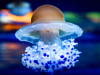
Cotylorhiza Tuberculata Jellyfish
In this close up of a Cotylorhiza Tuberculata Jellyfish, you can see the luminosity of her blue and white tentacles. The occurrence of identical luciferins for different types of organisms may suggest a dietary source for some groups strengthening the adage, you are what you eat, or perhaps you glow how you eat

Bacteria and fireflies have unique luminescent chemistries. Fireflies light up when oxygen combines with calcium, adenosine triphosphate (ATP) and luciferin in the presence of luciferase. 

For bacteria, the world stage of luminosity is quite small — and a bit gormless. Just how much light they emit and when is a free-for-all. Not so for the rest of our bioluminescent friends who have very precise control over when they shine and just how bright. 

Bioluminescence comes in a variety of colours, from blue through red. The colour is based on the chemistry, which involves a substrate molecule called luciferin, the source of energy that goes into light, and an enzyme called luciferase or photoprotein. 

Most of this lighting up of our world happens on land or in saltwater. There are almost no bioluminescent organisms native to freshwater.

In terrestrial plants and animals — fireflies, beetles and fungi like this Ghost Fungus, Omphalotus nidiformis, a gilled basidiomycete mushroom — we commonly find green, yellow, and sometimes red. 

In the ocean, bioluminescence is mostly blue-green or green. You would think that blues and green would not show up all that well in our seas but, surprisingly, they do. While sound travels better through saltwater than air, it is the reverse for light. 

Various colours of light do not transmit equally through saltwater. Once we move deeper than the top layer of the ocean warmed by the sun and brimming with nutrients, the epipelagic zone, and move deeper through the mesopelagic, deeper and deeper still to the bathypelagic, frigid abyssalpelagic and finally the deep trenches of the icy pressure and all but inhospitable hadalpelagic, less and less light — until no light — gets through.

It is the twilight of the mesopelagic, 200 - 1000 metres below the surface, that is the sweet spot for most of our bioluminescent friends. Here, only very faint sunlight gets through. The water pressure is higher than at the surface but still lacks the crushing intensity of the lower zones. It is here that bioluminescence becomes a real advantage — good real estate and the showmanship of light pays gold.

We know that the deeper you go in our oceans, less and less sunlight gets through, so if the purpose of bioluminescence is to provide a signal that is noticed by prey, potential mates and predators alike, it is important that the light moves through the seawater, and not be absorbed or scattered — and this plays out in the colours evolved to be seen here. 

If you have spent any time underwater, you will know that blue-green light transmits best through seawater. The deeper you go, the colours fade. Gone are the reds and yellows until everything looks brown or blue-green. Because of this, it is no surprise that blue-green is the most common colouring of bioluminescence in our oceans. 

There are some exceptions to the blue-green/green colour rule — minuscule planktonic polychaete worms, Tomopteris helgolandica, emit yellow light, and deep-sea fish Malacosteus niger in the family Stomiidae, the barbeled dragonfishes, produce both red and blue. 

Malacosteus niger's unique adaptation of producing red bioluminescence is only found in two other deep-sea dwelling creatures, Aristostomias and Pachystomias

This rare form of bioluminescence can reach up to 700 nm in the deep-sea and cannot be perceived by green and blue bioluminescent organisms — granting M. niger a considerable advantage while hunting at depth.

The red light may function as an invisible searchlight of sorts because most animals in the ocean cannot see red light, while the eyes of M. niger are red-sensitive. It is much easier to find and eat something that cannot see you, particularly if it is lit up like a tasty red holiday snack.

Reference: https://latzlab.ucsd.edu/bioluminescence/

Wednesday 28 December 2022

SEA ANEMONES: CNIDARIA

These colourful beauties are sea anemones. They are familiar inhabitants of rocky shores and coral reefs around the world — with some of their brethren found at very low depths in our oceans. They are one of the wonderful examples of the diversity that radiated out of the Cambrian Explosion.

In the Kwak̓wala language of the Kwakiutl or Kwakwaka'wakw, speakers of Kwak'wala, of the Pacific Northwest, sea anemones are known as 'mis'ma̱t̕sa. 

These beautiful predatory animals are a common site in tide pools all along the Pacific Coast. They form a large part of many special memories of exploring the tide pools along Storey's Beach on the east side of Vancouver Island as a child. 

Touching their soft tentacles is hypnotic and highly entertaining but our human skin is coated in oils and bacteria that may damage these delicate organisms. 

We sometimes see them turn up in First Nation's art — particularly in association with Kumugwe' or the Copper-Maker, Chief of the undersea world and the one to thank for the rising and ebbing of the tides.

At first glance, they look like beautiful and delicate marine flowers. If you have discovered them in tidepools, you will know that they retract or pull into themselves with the lightest touch. These would-be flowers are predatory marine animals of the order Actiniaria that have graced our oceans for over half a billion years. 

They are named after anemones — Anemonastrum, a genus of flowering plants in the family Ranunculaceae — because of their colourful flower-like appearance. Sea anemones are classified in the phylum Cnidaria, class Anthozoa, subclass Hexacorallia. 

As cnidarians, sea anemones are related to corals, jellyfish, tube-dwelling anemones, and Hydra. Jellyfish have a complex life cycle that includes both sexual and asexual phases, with the medusa being the sexual stage in most instances. 

A typical sea anemone is a single polyp attached to a hard surface by its base, but some species live in soft sediment and a few float near the surface of the water. The polyp has a columnar trunk topped by an oral disc with a ring of sticky tentacles that fold in towards its central mouth. If they have stung and paralyzed a tasty snack, it is pulled towards the gaping mouth to be consumed. 

The tentacles can be retracted or pulled back inside the body cavity or stretched out and expanded to catch passing prey. They are armed with cnidocytes or stinging cells. In many species, nourishment comes from a symbiotic relationship with single-celled dinoflagellates — zooxanthellae or with green algae, zoochlorellae, that live within the cells. Some species of sea anemone live in association with hermit crabs, small fish or other animals to their mutual benefit.

Most actinarians are sessile — that is, they live attached to rocks or other substrates and do not move, or move only very slowly by contractions of the pedal disk. 

A number of anemones burrow into sand, and a few can even swim short distances, by bending the column back and forth or by "flapping" their tentacles. In all, there are about 1000 species of sea anemone in the world's oceans — including those who live amongst the mythic sea lions that form the posts and beams of Kumugwe''s undersea home.

Sea anemones breed by releasing sperm and eggs through their mouth into the surrounding ocean. The fertilized eggs develop into wee planula larvae that live as tiny planktonic bits floating in the sea. Eventually, they settle on the seafloor and develop directly into juvenile polyps. Sea anemones can also breed asexually. They do this by breaking in half or into smaller pieces that regenerate into polyps.

We sometimes see these beauties kept in saltwater aquariums. I can understand the appeal but it comes with a price. The global trade in marine ornamentals threatens our lovely sea anemone populations. 

Most Actiniaria do not form hard parts that can be recognized as fossils, but a few fossils of sea anemones have been found. The bag-like — almost sea cucumber-like — Mackenzia, from the Middle Cambrian, Stephen Formation in the Canadian Rockies of British Columbia and Alberta, is the oldest fossil identified as a sea anemone. These ancient sea anemones attached themselves to hard surfaces, such as brachiopod shells in a similar fashion to their modern sessile cousins. 

Mackenzia costalis, Walcott 1911
Fourteen specimens of Mackenzia costalis are known from the Greater Phyllopod bed, where they make up less than <0.1% of the fossil community. Mackenzia was originally described by Charles Walcott in 1911 — but as a holothurian echinoderm, which was a reasonable assumption at the time. Once additional specimens had been found and studied, Mackenzia costalis was reclassified as a cnidarian and the great grandparent of our modern sea anemones.

Some fossil sea anemones have also been found from the Lower Cambrian of China. The new find lends support to genetic data that suggests anthozoans — anemones, corals, octocorals and their kin — were one the first Cnidarian groups to diversify. We will likely find more of these rare fossils over time and perhaps get a better view of their long lineage.

Photo: Charles Doolittle Walcott - Charles D. Walcott: Middle Cambrian Holothurians and Medusae. Smithsonian Miscellaneous Collections Volume 57, Number 3 (Publication 2011). City of Washington. Published by the Smithsonian Institution. June 13, 1911. 

References:  

Caron, Jean-Bernard; Jackson, Donald A. (October 2006). "Taphonomy of the Greater Phyllopod Bed community, Burgess Shale". PALAIOS. 21 (5): 451–65. doi:10.2110/palo.2003.P05-070R. JSTOR 20173022.

 Durham, J. W. (1974). "Systematic Position of Eldonia ludwigi Walcott". Journal of Paleontology. 48 (4): 750–755. JSTOR 1303225.

Conway Morris, S. (1993). "Ediacaran-like fossils in Cambrian Burgess Shale–type faunas of North America". Palaeontology. 36 (31–0239): 593–635.


Tuesday 27 December 2022

ANCIENT SNOW PLOW: WOOLLY MAMMOTHS

Woolly Mammoths, Mammuthus primigenius,  have always held wonder for me. These massive, hairy — and likely very smelly beasts — lived alongside us for a time. 

If you stood beside him and reached way up, you might be able to touch his tusks but likely not reach up to his mouth or even his eyes. 

He had a shaggy coat of light or dark coloured hair with long outer hair strands covering a dense thick undercoat. His oil glands would have worked overtime to secrete oils, giving him natural waterproofing. Some of the hair strands we have recovered are more than a meter in length. These behemoth proboscideans boasted long, curved tusks, little ears, short tails and grazed on leaves, shrubs and grasses that would have been hard work to get at as much of his world was covered in ice and snow during his reign.

We first see Woolly Mammoths in northeastern Siberia dating back 700,000 years. We find them in East Asia as far back as 800,000 years ago. They arose from the massive steppe mammoths, Mammuthus trogontherii, slowly evolving traits we see in this older species to the mammoths we think of today. 

Over time, their body size shrank and their teeth and tusks evolved to take advantage of the tough vegetation available to those few animals who could chew their way through ice and snow and work these tundra grasses into a digestible form. 

The enamel plates of their cheek teeth multiplied while the enamel itself became thinner. Tusks slowly took on more of a curved to act as ploughs for the snow. 

Those smaller than their predecessors, they were still formidable. Their size offered protection against predators once full grown. Sadly for the juveniles, they offered tasty prey to big cats like Homotherium who roamed these ancient grasslands alongside them.

The Mammoths of the Steppe spread to the northern areas of Eurasia, down through Europe, into the British Isles to Spain and crossed over to populate North America via the Bering Isthmus. It was the lowered sea levels during the last Ice Age that exposed dry land between Asia and the Americas. Here in this flat, grassy treeless plain known as the Bering Land Bridge or Isthmus, animals, including humans, could migrate from Europe west into North America.

The woolly mammoth coexisted with our ancestors who made good use of their bones and tusks for tools, housing, art and food. The last of their lineage died out relatively recently on Wrangel Island until 4,000 years ago — a time when we were making our first harps and flutes in Egypt, dams, canals and stone sculptures in Sumer, using numbers for the first time and using tin to make tools.

Monday 26 December 2022

KAZAKHSTAN ANAHOPLITES

This tasty block of Semenovites (Anahoplites) cf. michalskii ammonites hails from Cretaceous, Albian deposits that outcrop on the Tupqaraghan — Mangyshlak Peninsula on the eastern coast of the Caspian Sea, Kazakhstan. 

Present-day Kazakhstan is made up of several micro continental blocks that were broken up in the Cambrian and then crushed back together then smashed up against Siberia and came to rest where we find them today. 

Mangyshlak or Mangghyshlaq Peninsula is a large peninsula located in western Kazakhstan. It borders on the Caspian Sea in the west and with the Buzachi Peninsula, a marshy sub-feature of the main peninsula, in the northeast. The Tyuleniy Archipelago lies off the northern shores of the peninsula.

Lowlands make up one-third of Kazakhstan’s huge expanse, hilly plateaus and plains account for nearly half, and low mountainous regions about one-fifth. Kazakhstan’s highest point, Mount Khan-Tengri (Han-t’eng-ko-li Peak) at 22,949 feet (6,995 metres), in the Tien Shan range on the border between Kazakhstan, Kyrgyzstan, and China, contrasts with the flat or rolling terrain of most of the republic. 

The western and southwestern parts of Kazakhstan are dominated by the low-lying Caspian Depression, which at its lowest point lies some 95 feet below sea level. South of the Caspian Depression are the Ustyurt Plateau and the Tupqaraghan (formerly Mangyshlak) Peninsula jutting into the Caspian Sea. 

Vast amounts of sand formed the Greater Barsuki and Aral Karakum deserts near the Aral Sea, the broad Betpaqdala Desert of the interior, and the Muyunkum and Kyzylkum deserts in the south. Most of these desert regions have slight vegetative cover eeking out a slim existence fed by subterranean groundwater.

Depressions filled by salt lakes — whose water has largely evaporated — dot the undulating uplands of central Kazakhstan. 

In the north, the mountains reach about 5,000 feet, and there are similar high areas among the Ulutau Mountains in the west and the Chingiz-Tau Range in the east. In the east and southeast, massifs — enormous blocks of crystalline rock — are furrowed by valleys. 

The Altai mountain complex to the east sends three ridges into the republic, and, farther south, the Tarbagatay Range is an offshoot of the Naryn-Kolbin complex. Another range, the Dzungarian Alatau, penetrates the country to the south of the depression containing the icy waters of Lake Balkhash. The beautiful Tien Shan peaks rise along the southern frontier with Kyrgyzstan. 

As well as lovely ammonite outcrops, dinosaurian material and pterosaur remains are also found in Kazakhstan. The ammonites you see here are in the collections of the deeply awesome Emil Black.

Paleo Coordinates: 44 ° 35'46 ″ 51 ° 52'53″ 

Sunday 25 December 2022

SVALBARD: ICE, SNOW AND ICHTHYOSAURS

Reindeer, Rangifer tarandus 
Ho Ho Ho. Ice, Snow, Reindeer & Ichthyosaurs — Svalbard is just what I imagine my version of Valhalla to be like, without all the mead, murder and mayhem. 

This Norwegian archipelago sits between mainland Norway and the North Pole. 

One of the world’s northernmost inhabited areas, it is known for its rugged, remote terrain of glaciers and frozen tundra sheltering polar bears, reindeer and Arctic fox. 

It is also known for reindeer. The lovelies you see here are all females as the males lose their antlers in the winter. So Rudolf and the rest of Santa's crew who pull his sleigh for him would have all been females as they are pictured with antlers. They are also shown flying across the sky, so the science gets a bit creative.

The Northern Lights or Nordlys are visible during winter, and summer brings the Midnight Sun — sunlight 24 hours a day. Norway or Norge is one of the very few locations where sunset merges into the sunrise, with no darkness in between, creating a soft, captivating twilight in which to view the world. 

The Botneheia Formation is made up of dark grey, laminated shales coarsening upwards to laminated siltstones and sandstones. South of the type area, the formation shows four coarsening-upward units. 

The formation is named for Botneheia Mountain, a mountain in Nordenskiöld Land at Spitsbergen, Svalbard. It has a height of 522 m.a.s.l., and is located south of Sassenfjorden, east of the valley of De Geerdalen. 

Svalbard, Norway
I was asked recently if folk head out in the torrential rain or ice and snow to fossil collect. I would generally say yes for those where the potential prize always outweighs the weather. For Svalbard, it is a resounding yes. 

You have to remove the snow cover — or ice if you are impatient or unlucky — to get to the outcrops here. It is well worth the effort. Beneath the icy cover, you find lovely ammonoids and bivalves. 

Tastier still, ichthyosaur remains are found here. The first Triassic ichthyosaurs from Svalbard were found in the early 20th century. Now there are quite a few Triassic and Jurassic ichthyosaur species from this archipelago.

Two ichthyosaur specimens have been recovered that are of particular interest. They comprise part of the trunk and the caudal vertebral column respectively. 

Some features, such as the very high and narrow caudal and posterior thoracic neural spines, the relatively elongate posterior thoracic vertebrae and the long and slender haemapophyses indicate that they probably represent a member of the family Toretocnemidae. 

Ichthyosaur Bones
Numerous ichthyosaur finds are known from the underlying Lower Triassic Vikinghøgda Formation and the overlying Middle to Upper Triassic Tschermakfjellet Formation, the new specimens help to close a huge gap in the fossil record of the Triassic ichthyosaurs from Svalbard. 

There is a resident research group working on the Triassic ichthyosaur fauna, the Spitsbergen Mesozoic Research Group. 

Lucky for them, they often find the fossil remains fully articulated — the bones having retained their spatial relationship to one another. 

Most of their finds are of the tail sections of primitive Triassic ichthyosaurs. In later ichthyosaurs, the tail vertebrae bend steeply downwards and have more of a fish-like look. 

In these primitive ancestors, the tail looks more eel-like — bending slightly so that the spines on the vertebrae form more of the tail. 

Maisch, Michael W. and Blomeier, Dierk published on these finds back in 2009: Neues Jahrbuch für Geologie und Paläontologie - Abhandlungen Band 254 Heft 3 (2009), p. 379 - 384. Nov 1, 2009.

Svalbard, Norway (Norge)
Svalbard was so remote that there were no Inuit or First Nation settlements. It is certainly possible an earlier people came through these islands, but they did not leave any trace of their travels. 

The first documented travellers to explore Spitsbergen arrived in 1795 as part of a hunting expedition. They included people from the arctic town of Hammerfest in Norway's far north. They were an excellent choice as they were used to barren, inhospitable lands and sailed to discover more. 

We know them as the Coast Sámi — a hearty, rugged people probably best known in history for their chieftain, Ottar. He left Hammerfest in the 9th century to visit then join King Alfred the Great's court in a newly forming England. 

Expeditions to the remote islands of Svalbard continued into the early 1800s and finally, a settlement was eked out of the cold landscape and slowly expanded to the rest of the islands. While today the islands are called Svalbard, I would have named them for the Norwegian word for remote — fjernkontroll.

Aristoptychites euglyphus and Daonella sp.
This marvellous block is filled with Aristoptychites (syn = Arctoptychites) euglyphus (Mojsisovics, 1886) and Daonella sp., oyster-like clams or bivalves from the Middle Triassic, Ladinian, rugged windswept outcrops at the top of the Daonella Shales, Botneheia Formation, Spitzbergen, Edgeøya and Barentsøya, eastern Svalbard, Norway. 

Daonella and Monotis are important species for our understanding of biostratigraphy in the Triassic and are useful as Index fossils. 

Index fossils are fossils used to define and identify geologic periods or faunal stages. To be truly useful, they need to have a short vertical range, wide geographic distribution and rapid evolutionary development.

Daonellids preferred soft, soupy substrates and we tend to find them in massive shell beds. Generally, if you find one, you find a whole bunch cemented together in coquina. The lovely block you see here is in the collections of the deeply awesome John Fam. 

Learning Languages

The Sámi languages (/ˈsɑːmi/ SAH-mee), Sami or Saami, are a group of Uralic languages spoken by the Sámi people in Northern Europe in parts of northern Finland, Norway, Sweden, and extreme northwestern Russia. Of the world's languages, I find them the most difficult for my mind and tongue to wrap around. The Uralic languages will be familiar to you as Hungarian (Magyar nyelv), Finnish and Estonian. 

Since my Sámi is terrible, I will share a few words of Norwegian that may come in handy if you visit Svalbard and have a hankering for their tasty fossils or fossiler. To say, ice, snow, reindeer and ichthyosaurs in Norwegian, you would say: is, snø, reinsdyr og ikthyosaurer

To say, "hello, where can I find fossils?" Use, "Hei, hvor kan jeg finne fossiler?" An expression you may not need but circumstances being what they are, "That is a big polar bear," is "Det er en stor isbjørn." A solid follow-up would be, "nice bear, run..." as "Fin bjørn, løp..." Good luck with that.

Wishing you and yours the very best of the holidays however you celebrate. 

Saturday 24 December 2022

GOD JUL: TRILACINOCERAS NORVEGICUM

Trilacinoceras norvegicum
A lovely example of Trilacinoceras norvegicum (Sweet, 1958), a nektonic carnivorous cephalopod from Ordovician outcrops on Helgö Island, Hovindsholm, Helgøya, Lake Mjosa, Norway.

This has been a site of human habitation for more than 5,000 years. Vikings, kings, traders, farmers —  and geologists have walked these fields.

To give that timeframe a bit of context, that's about the age of Skara Brae, the Neolithic settlement in Orkney, Scotland — and older than Stonehenge which clocks in at 3000 BC to 2000 BC and the Great Pyramids — built around 2560 BC.

For my friend, Gale Bishop, that's about 469 km west or a good 7-hour drive from your ancestral home in Ask, just north of Bergen and just south of Knarvik where many of my relatives live — Hei du!

The fossils found here are part of the Engervik Member, Elnes Formation, Aseri, and date back to the Middle Ordovician, 463.5 - 460.9 million years ago. W. C. Sweet did fossil fieldwork here in the 1950s and published a paper on the Middle Ordovician of the Oslo Region, Norway 10. Nautiloid Cephalopods. Norsk Geologisk Tidsskrift 38:1-178.

Deservedly, Sweetoceras boreale is named for him and is one of the most delightful species names of all time. In the 1960s, Yochelson picked up where Sweet left off, continuing the survey of the Middle Ordovician of the Oslo region. I chose this Trilacinoceras for a holiday post because their curly tops remind me of a wee Norwegian gnome, or Nisse from the Norse niðsi, a dear little relative. My Swedish relatives call them Tomte, a throwback to Saint Birgitta of Sweden in the 1300s.

Helgøya is an island in Mjøsa located in the Ringsaker municipality of Hedmark county, Norway. It was formerly a part of the Nes municipality. 

Long before that, it was the ruling centre for the Kings in Hedmark, where bold men and women held great blót celebrations to Odin and planned raids and expansion into Europe and Russia — roughly A.D. 793 — the beginning of the Viking Age.

Today, it is lush and green and easy to explore — or fish. Mjøsa is Norway's largest lake, as well as one of the deepest lakes in Norway and in Europe. 

Battles have been fought on its waters and its depths hold interesting archaeological and paleontological secrets. They also hold a goodly amount of large and tasty trout, pike, perch, burbot and graylings.

Helgøya is the largest freshwater island in Norway at 18.3 km². The island is delightful to explore and home to 32 farms. One of the most beautiful of these is the Hovinsholm manor. You can visit the farm in both summer and winter — both equally beautiful — and enjoy a café, workshop or their Christmas market. They have lush gardens and some very friendly horses you can pet — or spoil with apples, as you do. The property is massive at 2012 acres, divided into grain, potatoes and forest. It has been home to kings and court. It was a monastery in the Middle Ages from the 5th to the 15th century. Today, Tolle Hoel Slotnæs and his wife, Charlotte Holberg Sveinsen own and run the manor with their three daughters.

Hovinsholm, Helgøya, Lake Mjosa, Norway
Helgøya means holy island, in Norwegian. There is a lovely double meaning here and such layered history. The manor, in its various iterations, has been on this site since the 1500s. They had their own Christian manor church until 1612.

On the southern tip of the island, there is an old pagan temple to the Norse Gods, Thor, Frigg, Loki, Hod, Heimdall, Tyr, and Baldur.

Here, farmers of the area would gather at four blót sacrifices a year that followed the seasons — one for each of the winter solstice, spring equinox, summer solstice and autumn equinox. Animals would be sacrificed, their blood splattered on altars, walls and folk around them. Toasts were made. The first was in honour of Thor or Odin, “to the king and victory.” 

Odin, although nominally chief of the gods, was more the god of aristocrats. If a king were toasting, particularly a Danish King, it would be for Odin. If you look at place names in Scandinavia, you'll see him conspicuously absent in favour of Thor, the god of the common man.

When the farmers at Helgøya were shouting Skål, it was likely for Thor. The toasting and drinking continued with cups emptied for Njörd and Freyr and Freyja in the hope of securing a prosperous future. 

Finally, personal pledges (and beer-soaked boasts) would be made to undertake great exploits, Valknut — to die well in battle — and finally to kinsmen laid to rest now drinking with the gods in Valhalla. Weapons, jewellery and tools were thrown into the lake as offerings.

If they were gathering for Jol (Old Norse), Jul (Norwegian) or the Yule blót, they'd also make a large sun wheel (picture a circle with a cross in the middle), carve it up with runes, set it on fire and roll it down a hill. 

It was quite a celebration with the festivities going on for three days and nights. With the formalities over, people did as people do  — drink, sing, boast, play games and find someone to bed down with — Gods be good.

Thor and Odin are still going strong nearly 1,000 years after the end of the Viking Age. You'd think that the old Nordic religion — the belief in the Norse gods — disappeared with the introduction of Christianity. That is not the case. There are still folk in Denmark (Odin-lovers) and Norway (Thor's their guy) who follow the old Norse religion and worship its ancient gods — right down to the splatter.

If you visit Norway at Christmas, Jul (Yule), you'll find much more of the pagan than the Christian in the festivities. King Haakon, old Haakon the Good, Hákon Góði or Håkon den Gode,  moved the Winter Solstice or Yule, Jul, Jol blót over to match up with the Christian holiday on December 25th in his attempts to introduce Christianity in the 10th century. Both traditions are still celebrated but without an overtly religious tone.

Old traditions run deep, animals are still sacrificed (but without all the splatter), bread is baked, houses cleaned, beer is abundant and fires warmth the hearth.

After all the drinking, toasting and feasting at the Jul blót, leftover food was not cleaned up but left overnight for the little relatives. Though shy, Nisse like a good feast and failing to offer them their tithe brings ill-fortune.

But we started this journey together admiring a lovely (and oddly festive) Ordovician cephalopod. Go on, picture him in red and white with a little beard. If you fancy a visit to the Ordovician outcrops, you can find them at Nes-Hamar, Norway. 60.0° N, 11.2° E: paleo-coordinates 33.7° S, 10.3° W. Look for gastropods (five known species) and cephalopods (at least 15 species).

If you'd like to visit the burial mound of Haakon the Good, you'll want to head to Seim, Hordaland, about 10 km north of Knarvik. Good 'ol Haakon may have tried to bring Christianity to Norway but he died full Viking — taking an arrow at the Battle of Fitjar. Many of my rellies live in Knarvik. 

We have enjoyed many a sunny afternoon feasting at the Håkonarspelet summer festivals and exploring Haakon's burial mound at Håkonhaugen in Seim.

If you're more of the manor type, you can stop by Hovinsholm gård, Helgøyvegen 850, 2350 Nes på Hedmarken, Norway. 

If you're curious and want to see the farmstead, head on over to: https://www.skafferiet.no/about. 

If you need to square things up with Odin, you're on your own.

E. L. Yochelson. 1963. The Middle Ordovician of the Oslo Region, Norway. 15. Monoplacophora and Gastropoda. Norsk Geologisk Tidsskrift 43 (2):133-213.

Friday 23 December 2022

LIMESTONE AND SALT: HALLSTATT

Hallstatt Salt Mines, Austria / Permian Salt Diapir
The Hallstatt Limestone is the world's richest Triassic ammonite unit, yielding specimens of more than 500 ammonite species.

Along with diversified cephalopod fauna  — orthoceratids, nautiloids, ammonoids — we also see gastropods, bivalves, especially the late Triassic pteriid bivalve Halobia (the halobiids), brachiopods, crinoids and a few corals. We also see a lovely selection of microfauna represented. 

For microfauna, we see conodonts, foraminifera, sponge spicules, radiolaria, floating crinoids and holothurian sclerites —  polyp-like, soft-bodied invertebrate echinozoans often referred to as sea cucumbers because of their similarities in size, elongate shape, and tough skin over a soft interior. 

Franz von Hauer’s exhaustive 1846 tome describing Hallstatt ammonites inspired renowned Austrian geologist Eduard Suess’s detailed study of the area’s Mesozoic history. That work was instrumental in Suess being the first person to recognize the former existence of the Tethys Sea, which he named in 1893 after the sister of Oceanus, the Greek god of the ocean. As part of the Northern Limestone Alps, the Dachstein rock mass, or Hoher Dachstein, is one of the large karstic mountains of Austria and the second-highest mountain in the Northern Limestone Alps. It borders Upper Austria and Styria in central Austria and is the highest point in each of those states.

Parts of the massif also lie in the state of Salzburg, leading to the mountain being referred to as the Drei-Länder-Berg or three-state mountain. Seen from the north, the Dachstein massif is dominated by the glaciers with the rocky summits rising beyond them. By contrast, to the south, the mountain drops almost vertically to the valley floor. The karst limestones and dolomites were deposited in our Mesozoic seas. The geology of the Dachstein massif is dominated by the Dachstein-Kalk Formation — the Dachstein limestone — which dates back to the Triassic.

Hallstatt and the Hallstatt Sea, Austria
There were several phases of mountain building in this part of the world pushing the limestone deposits 3,000 metres above current sea level. The rock strata were originally deposited horizontally, then shifted, broken up and reshaped by the erosive forces of ice ages and erosion.

The Hallstatt mine exploits a Permian salt diapir that makes up some of this area’s oldest rock. 

The salt accumulated by evaporation in the newly opened, and hence shallow, Hallstatt-Meliata Ocean. This was one of several small ocean basins that formed in what is now Europe during the late Paleozoic and early Mesozoic when the world’s landmasses were welded together to form the supercontinent Pangea. 

Pangea was shaped like a crescent moon that cradled the famous Tethys Sea. Subduction of Tethyian oceanic crust caused several slivers of continental crust to separate from Pangea, forming new “back-arc basins” (small oceans formed by rifting that is associated with nearby subduction) between the supercontinent and the newly rifted ribbon continents.

The Hallstatt-Meliata Ocean was one such back-arc basin. As it continued to expand and deepen during the Triassic, evaporation ceased and reefs flourished; thick limestone deposits accumulated atop the salt. When the Hallstatt-Meliata Ocean closed in the Late Jurassic, the compression squeezed the low-density salt into a diapir that rose buoyantly, injecting itself into the Triassic limestones above.

The Hallstatt salt diapir and its overlying limestone cap came to rest in their present position in the northern Austrian Alps when they were shoved northward as nappes (thrust sheets) during two separate collision events, one in the Cretaceous and one in the Eocene, that created the modern Alps. It is from the Hallstatt salt diapir that Hallstatt, like so many cities and towns, gets its name.

Deposits of rock salt or halite, the mineral name of sodium chloride with the chemical formula of NaCl, are found and mined around the globe. These deposits mark the dried remains of ancient oceans and seas. Names of rivers, towns and cities in Europe — Salzburg, Halle, Hallstatt, Hallein, La Salle, Moselle — all pay homage to their connection to halite and salt production. The Greek word for salt is hals and the Latin is sal. The Turkish name for salt is Tuz, which we see in the naming of Tuzla, a salt-producing region of northeastern Bosnia-Herzegovina and in the names of towns that dot the coast of Turkey where it meets the Black Sea. Hallstatt with its salt diapir is no exception.

The salt-named town of Hallstatt sits on the shores of the idyllic Hallstätter Sea at the base of the Dachstein massif. Visiting it today, you experience a quaint traditional fishing village built in the typical upper Austrian style. Tourism drives the economy as much as salt as this area of the world is picture-perfect from every angle.

Space is at a minimum in the town. For centuries, every ten years the local cemetery exhumes the bones of those buried there and moves them to an ossuary to make room for new burials. The Hallstatt Ossuary is called Karner, Charnel House, or simply Beinhaus (Bone House). Karners are places of secondary burials. They were once common in the Eastern Alps, but that custom has largely disappeared.

Hallstatt Beinhaus Ossuary, Hallstatt, Austria
A collection of over 700 elaborately decorated skulls rest inside the ossuary. They are lined up on rows of wooden shelves that grace the walls of the chapel. Another 500 undecorated skulls, bare and without any kind of adornment, are stacked in the corners.

Each is inscribed and attached to a record with the deceased's name, profession and date of death. The Bone House is located in a chapel in the basement of the Church of Saint Michael. The church dates from the 12th century CE. 

Decorating the skulls was traditionally the job of the local gravedigger and an honour granted to very few. At the family's request, garlands of flowers were painted on the skulls of deceased as decorative crowns if they were female. The skulls of men and boys were painted wreaths of oak or ivy.

Every building in Hallstatt looks out over the Hallstätter Sea. This beautiful mountain lake considered one of the finest of Austria's Salzkammergut region. It lies at the northern foot of the Dachstein mountain range, sitting eight-and-a-half kilometres long and two kilometres wide. The shoreline is dotted by the villages of  Obertraun, Steeg, and Hallstatt.

The region is habitat to a variety of diverse flora and fauna, including many rare species such as native orchids, in the wetlands and moors in the south and north.

Linked by road to the cities of Salzburg and Graz, Hallstatt and its lake were declared one of the World Heritage sites in Austria in 1997 and included in the Hallstatt-Dachstein Salzkammergut Alpine UNESCO World Heritage Site. The little market village of Hallstatt takes its name from the local salt mine.

Hallstatt, Salzkammergut region, Austria
The town is a popular tourist destination with its quaint shops and terraced cafes. In the centre of town, the 19th-century Evangelical Church of Hallstatt with its tall, slender spire is a lakeside landmark. You can see it here in the photo on the left.

Above the town are the Hallstatt Salt mines located within the 1,030-meter-tall Salzburg Salt Mountain. They are accessible by cable car or a three-minute journey aboard the funicular railway. There is also a wonderful Subterranean Salt Lake.

In 1734, there was a corpse found here preserved in salt. The fellow became known as the Man in Salt. Though no archaeological analysis was performed at the time — the mummy was respectfully reburied in the Hallstatt cemetery — based on descriptions in the mine records, archaeologists suspect the miner lived during the Iron Age. This Old Father, Senos ph₂tḗr, 'ɸatīr 'father' may have been a local farmer, metal-worker, or both and chatted with his friends and family in Celtic or Proto-Celtic.

Salt mining in the area dates back to the Neolithic period, from the 8th to 5th Centuries BC. This is around the time that Roman legions were withdrawing from Britain and the Goths sacked Rome. In Austria, agricultural settlements were dotting the landscape and the alpine regions were being explored and settled for their easy access to valuable salt, chert and other raw materials.

The salt-rich mountains of Salzkammergut and the upland valley above Hallstatt were attractive for this reason. The area was once home to the Hallstatt culture, an archaeological group linked to Proto-Celtic and early Celtic people of the Early Iron Age in Europe, c.800–450 BC.
Bronze Age vessel with cow and calf

In the 19th century, a burial site was discovered with 2,000 individuals, many of them buried with Bronze Age artefacts of amber and ivory.

It was this find that helped lend the name Hallstatt to this epoch of human history. The Late Iron Age, between around 800 and 400 BC, became known as the Hallstatt Period.

For its rich history, natural beauty and breathtaking mountainous geology, Hallstatt is a truly irresistible corner of the world.

Salzbergstraße 1, 4830 Hallstatt.  https://www.salzwelten.at/en/home/

Photo: Bronze vessel with cow and calf, Hallstatt by Alice Schumacher - Naturhistorisches Museum Wien - A. Kern – K. Kowarik – A. W. Rausch – H. Reschreiter, Salz-Reich. 7000 Jahre Hallstatt, VPA 2 (Wien, 2008) Seite 133 Abbildung 6. Hallstatt Village & Ossuary Photos: P. McClure Photography ca. 2015.

Bernoulli D, Jenkyns HC (1974) Alpine, Mediterranean, and Central Atlantic Mesozoic facies in relation to the early evolution of the Tethys. Soc Econ Paleont Mineral Spec Publ 19:129–160

Bernoulli D, Jenkyns H (2009) Ancient oceans and continental margins of the Alpine-Mediterranean Tethys: deciphering clues from Mesozoic pelagic sediments and ophiolites. Sedimentology 56:149–190

Thursday 22 December 2022

CEPHALOPODS OF HALLSTATT

This beautiful slab of well-preserved Triassic, Carnian, upper Tuvalian ammonoids hails limestone outcrops near the salt-mining town of Hallstatt, Salzburgerland, Austria.

This area of the world boasts one of the richest deposits of Triassic ammonite units — more than five hundred magnificent ammonite species are found here along with a diversified selection of cephalopod fauna  — orthoceratids, nautiloids, ammonoids — we also see gastropods, bivalves (including lovely halobiids), brachiopods, crinoids and a few corals. For microfauna, we see conodonts, foraminifera, sponge spicules, radiolaria, floating crinoids and holothurian sclerites —  polyp-like, soft-bodied "wormy" invertebrate echinozoans. On the left, you can see two specimens of Jovites bosniensis MOJS. The ammonoid in the middle of the plate is Juvavites sp. The right side of the block shows two Hypocladiscites subtornatus MOJS.

The larger specimen (15cm) is a phragmocone. Within its badly crushed body chamber (removed during prep) there are two washed in specimens of Disotropites plinii (MOJS.) You can see them visible in the side view on the top right. The Disotropites plinii subzone is the lower ammonoid subzone of the Tuvalian III.

The second picture here shows Hypocladiscites subtornatus from when it was first described as Arcestes subtornatus, in Mojs, 1873.

In the North American literature (after Tim Tozer) the Tuvalian is split into three Zones; starting with the Dilleri Zone, then the Welleri Zone and finally the Macrolobatus Zone on the very top.

The Dilleri zone is characterized by the rise of the genus Tropites sp. together with later members of the genus Neoprotrachyceras sp.

In the Welleri zone, Neoprotrachyceras sp. disappears and Tropites becomes a very common faunal element. The Macrolobatus zone is named after Klamathites macrolobatus, an endemic ammonite of the North American strata. Other genera of this zone are comparable to the time frame of the latest Tuvalian and the earliest Norian of the Alps. In the Hallstatt (Tethys) realm the following Division is made:

Dilleri Zone= Tuvalian I (literature gives little evidence for this zone). Subbullatus Zone = Tuvalian II — corresponding in most parts to the North American Welleri Zone. These are followed by the Anatropites Zone or Tuvalian III — corresponding in part to the North American Macrolobatus Zone.

In the Alps, the strata are divided between Tuvalian II and Tuvalian III. It is up for debate if all three North American zones can be included in these two alpine zones. It has been postulated by Spatzenegger that there is little evidence for a time gap in the lower Tuvalian of the Alpine strata.

Discotropites sandlingense is in the North America zone — a clear Dilleri faunal element. In the Alps, it is ranged into Tuvalian II (Welleri Zone). The same is true for the genus Traskites sp. — corresponding to alpine Sandlingites sp. Some ammonites of the upper part of the Macrolobatus zone are also placed within the alpine Norian stage. The correlation between the North American and Alpine zones is problematic and matching up the Tuvalian fauna is a tricky business.

Sirenites sp., Upper Triassic, Lower Carnian Julian Zone
Tuvalian 1 is recognizable in the Alps by the composition of the faunal spectrum — the quantity of some special genera. We see more of some, less of others, and this gives us a general sense of time.

In some strata, Trachysagenites sp. Sagenites inermis, Sandlingites sp. occur frequently together, with scarce Tropites sp. and Sirenites sp. and (very rarely) Neoprotrachyceras cf. thyrae.

The transition from Tuvalian to the Norian is confirmed only in one location in the Hallstatt limestone. Clustered onto blocks, the ammonoids show us the faunal mix and allow us to place them in time. The bedded profile of Tuvalian fauna (which is overlain by a Norian fauna) hails from the Feuerkogel near Hallstatt. Here we also find the lower transition of Julian to Tuvalian. Not far from this site are limestone outcrops that show the transition between the Carnian and Norian. Here the latest Tuvalian and lowermost Norian are confirmed only by the microfossil fauna.

The Hallstatt Limestone is the world's richest Triassic ammonite unit, yielding specimens of more than 500 ammonite species. Along with diversified cephalopod fauna — orthoceratids, nautiloids, ammonoids — we also see gastropods, bivalves (esp. halobiids), brachiopods, crinoids and a few corals.

Along with an amazing assortment of macrofossils, we see microfauna that are incredibly helpful in teasing out the geologic history of the area. Fossil conodonts, foraminifera, sponge spicules, radiolaria, floating crinoids and the bizarre holothurian sclerites — polyp-like, soft-bodied invertebrate echinozoans often referred to as sea cucumbers because of their similarities in size, elongate shape, and tough skin over a soft interior — can be found here.

Eduard Suess, Gondwana / Tethys Sea
Franz Ritter von Hauer’s exhaustive 1846 tome describing Hallstatt ammonites inspired renowned Austrian geologist Eduard Suess’s detailed study of the area’s Mesozoic history.

That work was instrumental in Suess being the first person to recognize the supercontinent of Gondwana (proposed in 1861) and the existence of the Tethys Sea, which he named in 1893 after the sister of Oceanus, the Greek god of the ocean.

Suess Land in Greenland, as well as the lunar crater Suess and Suess crater on Mars, are named after him.

The Hallstatt-Meliata Ocean was one such back-arc basin. As it continued to expand and deepen during the Triassic, evaporation ceased and reefs flourished; thick limestone deposits accumulated atop the salt. When the Hallstatt-Meliata Ocean closed in the Late Jurassic, the compression squeezed the low-density salt into a diapir that rose buoyantly, injecting itself into the Triassic limestones above.

This area has a rich and interesting geological and human history. I'm sure more studies will be done on the fossil marine fauna to untangle and standardize the Carnian subdivisions. For now, we'll muddle along with regional stratigraphies employing a two-substage subdivision, the Julian and Tuvalian. Others will continue to employ a three-substage organization of the stage: Cordevolian, Julian and Tuvalian. 

As I've pieced together this interesting Tuvalian tale, I have to thank Andreas Spatzenegger from Salzburg, Austria for his insights, work and amazing photos of the area. Kudos to you, my friends. I'd be mesmerized but still well confused about the Carnian subdivisions if not for you!

The genus Hypocladiscites ranges from the base Carnian to the lower Norian stage of the Upper Triassic. Photos and collection of the deeply awesome Andreas Spatzenegger of Salzburg, Austria.

Superfamilia: Arcestaceae MOJSISOVICS, 1875; Familia: Cladiscitidae ZITTEL, 1884; Subfamilia: Cladiscites GAMSJÄGER, 1982; Genus: Hypocladiscites MOJSISOVICS, 1896

Photo: A spectacular example of Sirenites sp., Upper Triassic, Lower Carnian, Julian Zone of Trachyceras aonoides. From Hallstatt Limestone of Austria. This specimen is about 5cm. Photo and collection of the deeply awesome Andreas Spatzenegger.

Photo: Eduard Suess (1831–1914), lithograph by Josef Kriehuber (1800–1876) c. 1869 by Josef Kriehuber - File:Eduard Sueß.jpg (cropped), Public Domain https://commons.wikimedia.org/w/index.php?curid=31526345

Wednesday 21 December 2022

HAIDA GWAII: ISLAND OF THE PEOPLE

A wreck with tales to tell at Naikoon, Haida Gwaii. The islands have gone by many names. To the people who call the islands home, Haida Gwaii means “island of the people,” it is a shortened version of an earlier name, Haadala Gwaii-ai, or “taken out of concealment.” 

Back at the time of Nangkilslas, it was called Didakwaa Gwaii, or “shoreward country.” 

By any name, the islands are a place of rugged beauty and spirit and enjoy a special place in both the natural and supernatural world. The enormous difference between high and low tide in Haida Gwaii – up to twenty three vertical feet – means that twice a day, vast swathes of shellfish are unveiled, free for the taking. 

An ancient Haida saying is still often heard today, “When the tide is out, the table is set.” Archaeological evidence shows that by about five thousand years ago, gathering shellfish replaced hunting and fishing as their primary food source. The shellfish meat was skewered on sticks, smoked and stored for use in winter or for travel.

Steeped in mist and mythology, the islands of Haida Gwaii abound in local lore that surrounds their beginnings. Today, the Hecate Strait is a tempestuous 40-mile wide channel that separates the mist-shrouded archipelago of Haida Gwaii from the BC mainland. Haida oral tradition tells of a time when the strait was mostly dry, dotted here and there with lakes. During the last ice age, glaciers locked up so much water that the sea level was hundreds of feet lower than it is today. Soil samples from the sea floor contain wood, pollen, and other terrestrial plant materials that tell of a tundra-like environment.

The islands of Haida Gwaii are at the western edge of the continental shelf and form part of Wrangellia, an exotic terrane of former island arcs, which also includes Vancouver Island, parts of western mainland British Columbia and southern Alaska. 

Brewericeras hulenense (Anderson, 1938)
While we’ll see that there are two competing schools of thought on Wrangellia’s more recent history, both sides agree that many of the rocks, and the fossils they contain, were laid down somewhere near the equator. 

They had a long, arduous journey, first being pushed by advancing plates, then being uplifted, intruded, folded, and finally thrust up again. It’s reminiscent of how pastry is balled up, kneaded over and over, finally rolled out, then the process is repeated again.

This violent history applies to most of the rock that makes up the Insular Belt, the outermost edge of the Cordillera. Once in their present location, the rocks that make up the mountains and valleys of this island group were glaciated and eroded to their present form. Despite this tumultuous past, the islands have arguably the best-preserved and most fossil-rich rocks in the Canadian Cordillera, dating from very recent to more than 200 million years old. 

The fossils found in the Triassic rock of Wrangellia are equatorial or low latitude life forms quite different from those found today on the Continent at the latitude of Haida Gwaii. This suggests those rocks were in the equatorial region during the Late Triassic, just over 200 million years ago. 

The Lower Jurassic ammonite faunas found at Haida Gwaii are very similar to those found in the Eastern Pacific around South America and in the Mediterranean. The strata exposed at Maple Island, Haida Gwaii are stratigraphically higher than the majority of Albian localities in Skidegate Inlet. The macrofossil fauna belonged to the Upper part of the Sandstone Member of the Haida formation.

The western end of the island contains numerous well-preserved inoceramids such as Birostrina concentrica and a few rare ammonites of Desmoceras bearskinese. The eastern shores are home to unusual ammonite fauna in the finer grained sandstones. Here we find the fossils as extremely hard concretions while others were loose in the shale. Species include Anagaudryceras sacya and Tetragonites subtimotheanus. A large whorl section of the rare Ammonoceratites crenucostatus has also been found here. The ammonites, Desmoceras; Brewericeras hulenense; Cleoniceras perezianum, Douvelliceras spiniferum are all found in Lower Cretaceous, Middle Albian, Haida Formation deposits.

Monday 19 December 2022

PORPOISE: K'ULUT'A

Dall's Porpoise
These delightfully friendly and super smart fellows are Dall's porpoise. 

In the Kwak̓wala language of the Kwakiutl or Kwakwaka'wakw, speakers of Kwak'wala, of the Pacific Northwest, a blowhole is known as a ka̱'was, whether on a dolphin (porpoise) or whale and a porpoise is known as a k̓ulut̕a

In the Pacific Northwest, we see many of their kind — the shy, blunt-nosed harbour porpoise, the social and herd-minded Pacific white-sided dolphin and the showy and social Dall's porpoise.  

Of these, the Dall's porpoise is a particular favourite. These speedy muscular black and white showboats like to ride the bow waves of passing boats — something they clearly enjoy and a thrill for everyone on board the vessel. If you slow down, they will often whisk away, but give them a chance to race you and they may stay with you all afternoon. 

Harbour porpoises are the complete opposite. You are much more likely to see their solid black bodies and wee fin skimming through the waves across the bay as they try to avoid you entirely. Harbour porpoise prefer quiet sheltered shorelines, often exploring solo or in small groups of two or three. 

We sometimes see these lovely marine mammals represented in the art of the First Nations in the Pacific Northwest, particularly along the coast of British Columbia. You will know them from their rather rectangular artistic depiction with a pronounced snout and lacking teeth (though they have them) used to portray killer whales or orca. 

As a group, even considering the shy Harbour porpoise, these marine mammals are social and playful. Humpback whales are fond of them and you will sometimes see them hanging out altogether in the bays and inlets or near the shore. 

They are quite vocal, making lots of distinctive and interesting noises in the water. They squeak, squawk and use body language — leaping from the water while snapping their jaws and slapping their tails on the surface. They love to blow bubbles, will swim right up to you for a kiss and cuddle. 

Each individual has a signature sound, a whistle that is uniquely their own. They use these whistles to tell one of their friends and family members from another.

Porpoise are marine mammals that live in our world's oceans. If it is salty and cold, you can be pretty sure they are there. They breathe air at the surface, similar to humans, using their lungs and inhaling and exhaling through a blowhole at the top of their heads instead of through their snouts. 


Sunday 18 December 2022

NORTH SEA FOSSIL DOLPHIN VERTEBRAE

A lovely 12 cm creamy orange Bottlenose Dolphin, Tursiops sp. lumbar vertebrae found in the Brown Bank area of the North Sea, one of the busiest seaways in the world.

Bottlenose dolphins first appeared during the Miocene and swam the shallow seas of this region. We still find them today in warm and temperate seas worldwide though unlike narwhal, beluga and bowhead whales, Bottlenose dolphins avoid the Arctic and Antarctic Circle regions. 

Their name derives from the Latin tursio (dolphin) and truncatus for their characteristic truncated teeth

We find their remains in the sediments of the North Sea. There are two known fossil species from Italy that include Tursiops osennae (late Miocene to early Pliocene) from the Piacenzian coastal mudstone, and Tursiops miocaenus (Miocene) from the Burdigalian marine sandstone.

Many waterworn vertebrae from the Harbour Porpoise Phocoena sp., (Cuvier, 1816), Bottlenose dolphin Tursiops sp. (Gervais, 1855), and Beluga Whale, Delphinapterus sp. (Lacépède‎, 1804‎) are found by fishermen as they dredge the bottom of the Brown Bank, one of the deepest sections of the North Sea.  

The North Sea is a sea of the Atlantic Ocean located between the United Kingdom, Denmark, Norway, Germany, the Netherlands, Belgium and France. An epeiric sea on the European continental shelf, it connects to the ocean through the English Channel in the south and the Norwegian Sea in the north.

The fishermen use small mesh trawl nets that tend to scoop up harder bits from the bottom. This technique is one of the only ways this Pleistocene and other more recent material is recovered from the seabed, making them relatively uncommon. The most profitable region for fossil mammal material is in the Brown Bank area of the North Sea. I've circled this area on the map below to give you an idea of the region.

Brown Bank, North Sea, Pleistocene Dredging Area
In May 2019, an 11-day expedition by European scientists from Belgium and the United Kingdom was undertaken to explore three sites of potential geologic and archaeologic interest in the southern North Sea. 

It has long been suspected that the southern North Sea plain may have been home to thousands of people, and chance finds by fishermen over many decades support this theory. 

A concentration of archaeological material, including worked bone, stone and human remains, has been found within the area around the Brown Bank, roughly 100 km due east from Great Yarmouth and 80 km west of the Dutch coast. The quantities of material strongly suggest the presence of a prehistoric settlement. As such the Brown Bank provides archaeologists with a unique opportunity to locate a prehistoric settlement in the deeper and more remote areas of the North Sea, known today as Doggerland.

Until sea levels rose at the end of the last Ice Age, between 8-10,000 years ago, an area of land connected Great Britain to Scandinavia and the continent.  It has long been suspected that the southern North Sea plain was home to thousands of people, and chance finds by fishermen over many decades support this theory. 

Over the past decades a concentration of archaeological material, including worked bone, stone and human remains, has been found within the area around the Brown Bank, roughly 100 km due east from Great Yarmouth and 80 km west of the Dutch coast. 

The quantities of material strongly suggest the presence of a prehistoric settlement. 

As such the Brown Bank provides archaeologists with a unique opportunity to locate a prehistoric settlement in the deeper and more remote areas of the North Sea, known today as Doggerland.

Prospecting for such a settlement within the North Sea is a challenging activity.  Multiple utilities cross the area, bad weather is frequent, and visibility underwater is often limited.  Given these challenging conditions, researchers on the Belgian vessel, RV Belgica, used acoustic techniques and physical sampling of the seabed to unravel the topography and history of the areas chosen for the survey.  

During the survey, the team used a novel parametric echosounder from the Flanders Marine Institute (VLIZ). This uses sonar technology to obtain images of the sub-bottom with the highest possible resolution and was combined with the more traditional “sparker” seismic source to explore deeper sediments.  On the Brown Bank, the Belgica also deployed a grab and a Gilson dredge for sampling near-surface stratigraphy. Video footage was collated using VLIZ’s dedicated video frame and a simpler GoPro mounted on the Gilson dredge. A video showing the equipment in operation on the expedition can be seen at https://youtu.be/sGKfyrDCtmw

Additional reading: http://www.vliz.be/en/press-release/update-research-prehistoric-settlements-North-Sea