Showing posts with label HISTORY. Show all posts

Sunday 3 July 2022

HEROES, VILLIANS AND TYRANTS: HORNBY ISLAND HISTORY

Villains, tyrants and heroes alike are immortalized in the scientific literature as researchers don each new species a unique scientific name — and rename geographic sites with a settlers' mindset. 

If you pick through the literature, it is a whose who of monied European explorers literally making a name for themselves, sometimes at great cost to their rivals. 

This truth plays out on British Columbia's West Coast and gulf islands and on Hornby Island, in particular. 

The beautiful island of Hornby is in the traditional territory of the Pentlatch or K’ómoks First Nation, who call it Ja-dai-aich, which means the outer island — a reference to Hornby being on the outside of Denman Island off the east coast of Vancouver Island. 

The island is a mix of beach and meadow, forest and stream. While I often walk the lower beachfront, this island boasts a lovely and very walkable mixed forest that covers its higher ground. 

If you explore here, off the beaten path, you will see a mix of large conifers — Western Hemlock, Grand Fir and Lodgepole Pine on the island. Of these, the Western Red Cedar, Thuja plicata, is the most prized by First Nations. It is the Tree of Life that provides bountiful raw materials for creating everything from art to homes to totems and canoes. 

If you explore these forests further, you will also see wonderful examples of the smaller Pacific yew, Taxus brevifolia, a wee evergreen that holds a special place in the hearts of First Nations whose carvers use this wood for bows and paddles for canoes.

Many spectacular specimens of arbutus, Arbutus menziesii, grow along the water's edge. These lovely evergreens have a rich orange-red bark that peels away in thin sheets, leaving a greenish, silvery smooth appearance and a satiny sheen. Arbutus, the broadleaf evergreen species is the tree I most strongly associate with Hornby. Hornby has its fair share of broadleaf deciduous trees. Bigleaf maple, red alder, black cottonwood, Pacific flowering dogwood, cascara and several species of willow thrive here.

There are populations of Garry oak, Quercus garryana, with their deeply lobed leaves, on the southern end of the island and at Helliwell Provincial Park on a rocky headland at the northeast end of Hornby. 
Local First Nations fire-managed these stands of Garry oak, burning away shrubs and other woody plants so that the thick-barked oaks and nutritious starch-rich plants like great camas, Camassia leichtlinii, could thrive without any nutrient competitors. 

Only about 260 acres (1.1 km2) of undisturbed stands of older forests have been identified on Hornby. They amount to roughly 3.5% of the island's surface area. There are roughly 1,330 acres (540 ha) of older second-growth stands on the island, roughly 19% of the island.

Most of the trees you see on the island are Douglas fir, Pseudotsuga menziesii, an evergreen conifer species in the pine family. My Uncle Doug recognized this tree species because of how much the bark looks like bacon — a food he loved. The common name is a nod to the Scottish botanist, David Douglas, who collected and first reported on this large evergreen.

Captain George Vancouver's Commission to Lieutenant
Sadly for Douglas, it is Archibald Menzies, a Scottish physician, botanist, naturalist — and David's arch-rival, whose name is commemorated for science. 

He is also credited with the scientific naming of our lovely arbutus trees. 

Menzies was part of the Vancouver Expedition (1791–1795) a four-and-a-half-year voyage of exploration commanded by Captain George Vancouver of the British Royal Navy.

Their voyage was built on the work of James Cook. Cook was arguably the first ship's captain to ensure his crew remained scurvy free by implementing a practice of nutritious meals — those containing ascorbic acid also known as Vitamin C — and meticulous standards for onboard hygiene. 

Though he did much to lower the mortality rate amongst his crew, he made some terrible decisions that led to his early demise. Cook was attacked and killed in 1779 during his third exploratory voyage in the Pacific while attempting to kidnap the Island of Hawaii's monarch, Kalaniʻōpuʻu. 

During the four and a half year Vancouver Expedition voyage, the crew and officers bickered amongst themselves, circumnavigated the globe, touching down on five continents. Little did they know, for many of them it would be the last voyage they would ever take. 

The expedition returned to a Britain more interested in its ongoing war than in Pacific explorations. Vancouver was attacked by the politically well-connected Menzies for various slights, then challenged to a duel by Thomas Pitt, the 2nd Baron of Camelford. 

The fellow for whom the fair city of Vancouver is named never did complete his massive cartographical work. With health failing and nerves eroded, he lost the dual and his life. It was Peter Puget, whose name adorns Puget Sound, who completed Vancouver's — and arguably Cook's work on the mapping of our world.

And while it is now called Vancouver the city has many names as it falls within the traditional territory of three Coast Salish peoples — the Squamish (Sḵwxwú7mesh), Tsleil-waututh and Xwméthkwyiem ("Musqueam"—from masqui "an edible grass that grows in the sea"), and on the southern shores of Vancouver along the Fraser River, the Xwméthkwyiem.

If you would like to explore more of the history of eponymous naming from Linnaeus to Darwin, to Bowie himself, take a boo at a new book from Stephen B. Heard, "Charles Darwin's Barnacle and David Bowie's Spider. It is fresh off the press and chock full of historical and pop-culture icons.

References: The City of Vancouver Archives has three George Vancouver documents of note:
  • The Commission, dated July 10, 1783, appointing him fourth Lieutenant of the HMS Fame (this is the official document confirming a field commission given to him May 7, 1782)
  • A letter to James Sykes (a Navy Agent in London) written from the ship Discovery (not the same Discovery used by Cook) while in Nootka Sound near the end of Vancouver’s exploration of the West Coast, October 2, 1794. Vancouver states that they have determined that the Northwest Passage does not exist, which was one of the main goals of his voyage
  • A letter to James Sykes written from Vancouver’s home in Petersham, England, after his voyage, October 26, 1797 

Friday 24 June 2022

CAPILANO RIVER: STONE, BONE & WATER

Cretaceous Plant Material / Three Brothers Formation
Vancouver has a spectacular mix of mountains, forests, lowlands, inlets and rivers all wrapped lovingly by the deep blue of the Salish Sea. 

When we look to the North Shore, the backdrop is made more spectacular by the Coast Mountains with a wee bit of the Cascades tucked in behind.

If you were standing on the top of the Lion's Gate Bridge looking north you would see the Capilano Reservoir is tucked in between the Lions to the west and Mount Seymour to the east on the North Shore. 

The bounty of that reservoir flows directly into your cup. If you look down from the reservoir you see the Capilano River as it makes its way to the sea and enters Burrard Inlet.

The Capilano River on Vancouver's North Shore flows through the Coast Mountains and our coastal rainforest down to the Capilano watershed enroute to Burrard Inlet. The headwaters are at the top of Capilano up near Furry Creek. They flow down through the valley, adding in rainwater, snowmelt and many tributaries before flowing into Capilano Lake. The lake in turn flows through Capilano Canyon and feeds into the Capilano River.

Today, for many, the Capilano River is the clear, cold water with which we fill our cups. But not so long ago, this Kia’palano, this beautiful river, was the entry point to Homulchesan, traditionally called X̱wemelch'stn, whose name means fast-moving water of fish and the domain of Douglas fir trees and the wild sacred salmon who spawn here.

Capilano Watershed & Reservoir
Sacred First Nations Land

This area was once the exclusive domain of the Coast Salish First Nations —  xʷmə?kʷəyəm (Musqueam), Skwxwú7mesh (Squamish), and səlilwətaɬ (Tsleil-Waututh) Nations until the early 1800s. 

The Musqueam First Nation are traditional hən̓q̓əmin̓əm̓ speaking people who number a strong and thriving 1,300. Many live today on a wee slip of their traditional territory just south of Marine Drive near the mouth of the Fraser River. 

The Secwepemc or Shuswap First Nations are a collective of 17 bands occupying the south-central part of British Columbia. Their ancestors have lived in the interior of BC, the Secwepemc territories, for at least 10,000 years.

The Coast Salish First Nations have lived in this region for thousands of years — from the mouth of the Columbia River in Oregon to north of Bute Inlet. They ancestors of those who live here today braved the cold, following the receding of the ice to forge new roots, build villages and strengthen their connections to this land.   
It is to the Squamish Nation that we owe the name of Capilano which is an anglicized version of Kia'palano. 

In Sḵwx̱wú7mesh snichim or Skwxwú7mesh, their spoken language, Kia'palano/Capilano means beautiful river

Chief Kia'palano (c. 1854-1910) was the Chief of the Squamish Nation from 1895-1910 — and Chief of the territory where this beautiful river flows — Sa7plek.
 
The Cleveland Dam — Capilano River Regional Park

Many things have changed since then, including the Capilano River's path, water levels and sediment deposition. For the salmon who used this path to return home and those who depended on them, life has been forever altered by our hands. The Capilano River still runs with Summer Coho, Spring & Summer Steelhead and Autumn Chinook. The small numbers of Spring/Summer Steelhead are maintained through catch and release and may one day reach their former levels of plenty along Vancouver’s North Shore. Elsewhere, we are beginning to see a rewilding of Vancouver with the return of the salmon to our rivers these past few years. 

It is a hopeful recovery from an amazing creature and their will to not just survive but thrive. Marina Dodis, a local film maker has done a wonderful job of recording that rewilding in her film, The Return. I'll pop a link below for you to watch it. I'm sure you'll enjoy it as much as I did.

We have Ernest Albert Cleveland to thank for the loss of that salmon but can credit him with much of our drinking water as it is caught and stored by the dam that bears his name. It was his vision to capture the bounty from the watershed and ensure it made its way into our cups and not the sea. 

Both the water and a good deal of sediment from the Capilano would flow into Burrard Inlet if not held back by the 91-metre concrete walls of the Cleveland Dam. While it was not Ernest's intention, his vision and dam had a secondary impact. In moving the mouth of the Capilano River he altered the erosion pattern of the North Shore and unveiled a Cretaceous Plant Fossil outcrop that is part of the Three Brothers Formation.

Capilano River Canyon & Regional Park
Know Before You Go

The fossil site is easily accessible from Vancouver and best visited in the summer months when water levels are low. 

The level of preservation of the fossils is quite good. The state in which they were fossilized, however, was not ideal. They look to have been preserved as debris that gathered in eddies in a stream or delta.

There are Cretaceous fossils found only in the sandstone. You will see exposed shale in the area but it does not contain fossil material. 

Interesting, but again not fossiliferous, are the many granitic and limestone boulders that look to have been brought down by glaciers from as far away as Texada Island. Cretaceous plant material (and modern material) found here include Poplar (cottonwood)  Populus sp. Bigleaf Maple, Acer machphyllum, Alder, Alnus rubra, Buttercup  Ranvuculus sp., Epilobrium, Red cedar, Blackberry and Sword fern.

Capilano Fossil Field Trip:

From downtown Vancouver, drive north through Stanley Park and over the Lion’s Gate Bridge. Take the North Vancouver exit toward the ferries. Turn right onto Taylor Way and then right again at Clyde Avenue. Look for the Park Royal Hotel. Park anywhere along Clyde Avenue.

From Clyde Avenue walk down the path to your left towards the Capilano River. Watch the water level and tread cautiously as it can be slippery if there has been any recent rain. Look for beds of sandstone about 200 meters north of the private bridge and just south of the Highway bridge. The fossil beds are just below the Whytecliff Apartment high rises. Be mindful of high water and slippery rocks.

Visiting the Capilano Watershed and Reservoir:

Visitors can see the reservoir from Cleveland Dam at the north end of Capilano River Regional Park. You can also visit the Capilano River Hatchery, operated below Cleveland Dam since 1971.

IN THE HEART OF THE CITY, A WILD MIRACLE AWAITS — THE RETURN, a film by the supremely talented Marina Dodis

There is something astonishing happening in the city of Vancouver. Largely unnoticed amidst vehicle traffic, industrial sites and construction, wild salmon are returning to their ancient spawning grounds.

Once an important salmon bearing area, this watershed became severely degraded as the city grew. The run collapsed and was declared “dead”. As salmon are iconic for people in British Columbia, concerned citizens became engaged. The rewilding has begun to pay off. After disappearing for 80 years, people can now witness the autumn spectacle of these powerful swimmers fighting to reach the streams they hatched in. To have a salmon run taking place within city limits is almost completely unique in a metropolis of this size.

Filmed with a quiet, observing lens over many years, "The Return" takes us into hidden enclaves of wilderness within the city, where tiny salmon smolts shimmer beneath the water's surface. Now that they have come back, their future is in our hands.

Link: https://madodis.wixsite.com/the-return?fbclid=IwAR349gFSZtmb3FN4iZRP6AGLyTH0O7MQnQbY-Prup6Qa0ICUzdhaw3vCkSk

Thursday 23 June 2022

STANLEY PARK: LIVED HISTORY

Totem, Welcome & Mortuary Poles at Stanley Park
If you visit Brockton Point in Stanley Park, there are many carved red cedar First Nation poles for you to admire.  

What you are viewing are replicas of First Nation welcome and totem poles that once stood in the park but have been returned to their homes within the province's diverse First Nation communities — or held within museum collections. 

Some of the original totems came from Alert Bay on Cormorant Island, near the Port McNeill on the north coast of Vancouver Island. 

Others came from communities in Haida Gwaii — and still more from the Wuikinuxv First Nations at Rivers Inlet on British Columbia's central west coast — home of the Great Bear Rainforest with her Spirit Bears.

The exception is the most recent addition carved by Robert Yelton in 2009. Robert is a First Nation carver from the Squamish Nation and his original welcome pole graces Brockton Point, the original settlement site of a group of Squamish-Portuguese settlers.  

If you look at the photo above, the lovely chocolate, red and turquoise pole on the right is a replica of the mortuary pole raised to honour the Raven Chief of Skedans or Gida'nsta, the Haida phrase for from his daughter, the title of respect used when addressing a person of high rank. Early fur traders often took the name of the local Chief and used it synonymously as the place names for the sites they visited — hence Skedans from Gida'nsta.

Chief Skedans Mortuary Pole
Chief Skedans, or Qa'gials qe'gawa-i, to his children, lived in Ḵ’uuna Llnagaay, or village at the edge, in Xaayda Kil — a village on the exposed coast of Louise Island — now a Haida Heritage Site.  

There are some paintings you may have seen by Emily Carr of her visits to the site in 1912, She used the phonetic Q'una from Q:o'na to describe both the place name and title of her work. 

Carr's paintings of the totems have always looked to me to be a mash-up — imagine if painter Tamara de Lempicka and photographer Edward Curtis had a baby — not pretty, but interesting.

Some called this area, Huadju-lanas or Xu'adji la'nas, which means Grizzly-Bear-Town, in reference to resident grizzly bear population and their adornment of many totems and artwork by the local artists.

Upon Chief Skedan's death, the mortuary pole was carved both to honour him and provide his final resting place. Dates are a bit fuzzy, but local accounts have this as sometime between 1870-1878 — and at a cost of 290 blankets or roughly $600 in today's currency. 

The great artistry of the pole was much admired by those in the community and those organizing the celebrations for the 1936 Vancouver Golden Jubilee — witnessed by  350,000 newly arrived residents.

Negotiations were pursued and the pole made its way down from Haida Gwaii to Stanley Park in time for the celebrations. The original totem graced Stanley Park for a little over twenty years before eventually making its way back to Haida Gwaii. It was returned to the community with bits of plaster and shoddy paint marring the original. These bits were scraped off and the pole welcomed back with due ceremony. 

In 1964, respected and renowned Northwest Coast master carver, Bill Reid, from the Kaadaas gaah Kiiguwaay, Raven/Wolf Clan of T'anuu, Haida Gwaii and Scottish-German descent, was asked to carve this colourful replica. 

Mountain Goat Detail, Skedans Mortuary Pole
Reid carved the totem onsite in Stanley Park with the help of German carver Werner True. Interestingly, though I looked at length for information on Werner True, all I can find is that he aided Bill Reid on the carving for a payment of $1000.

Don Yeomans, Haida master carver, meticulously recarved the moon crest in 1998. If you have admired the totem pole in the Vancouver Airport, you will have seen some of Yeoman's incredible work. 

The crest is Moon with the face, wings, legs and claws of a mighty and proud Thunderbird with a fairly smallish hooked beak in a split design. We have Moon to thank for the tides and illuminating our darkest nights. As a crest, Moon is associated with transformation and acting as both guardian and protector.

The original pole had a mortuary box that held the Chief's remains. The crest sits atop a very charming mountain goat. I have included a nice close-up here of the replica for you to enjoy. 

Mountain Goats live in the high peaks of British Columbia and being so close to the sky, they have the supernatural ability to cross over to the sky world. They are also credited as being spirit guardians and guides to First Nation shamans.

I love his horns and tucked in cloven hooves. There is another pole being carved on Vancouver Island that I hope to see during its creation that also depicts a Mountain Goat. With permission and in time, I hope to share some of those photos with you. 

Mountain Goat is sitting atop Grizzly Bear or Huaji or Xhuwaji’ with little human figures placed in his ears to represent the Chief's daughter and son-in-law, who raised the pole and held a potlatch in his honour. 

Beneath the great bear is Seal or Killer Whale in his grasp. The inscription in the park says it is a Killer Whale but I am not sure about that interpretation — both the look and lore make Seal more likely. Perhaps if Killer Whale were within Thunderbird's grasp — maybe

Though it is always a pleasure to see Killer Whale carved in red cedar, as the first whales came into being when they were carved in wood by a human — or by Raven — then magically infused with the gift of life. We think of totem pole as being part of the material culture of all Indigenous cultures across Canada when, indeed, they are carved by only a few and not always in the ways that you expect. 

Some are welcome poles, others record the loss of a loved one in a mortuary pole, some have spread wings like those carved by the Kwakwaka'wakw. 

Some are house fronts or house posts, others are shaped like an entryway versus the tall thin poles you might expect. 

We can thank the talented artists of the Haida, Nuxalk, Kwakwaka'wakw, Tlingit, Tsimshian and Coast Salish for the poles we enjoy in the Pacific Northwest. 

It is their storytelling and clan crests that we are enjoying when we look upon these carvings. These are the stories of their ancestors, their heroics, challenges, titles, deeds and sorrow. Each a masterpiece as a visual that supports an oral tradition—stories told and reinforced year-upon-year at Winter ceremonies.

Siwash Rock on the northern end of Third Beach, Stanley Park
The ground these totems sit upon is composed of plutonic, volcanic and sedimentary layers of rock and exhibits the profound influences of glaciation and glacial retreat from the last ice age. 

Glacial deposits sit atop as a mix of clay, sand, cobbles and larger boulders of glacial till. 

There are a few areas of exposed volcanics within the park that speak to the scraping of the glaciers as they retreated about 12,500 years ago. 

The iconic moss and lichen coated Siwash Rock on the northern end of Third Beach is one of the more picturesque of these. It is a basaltic and andesitic volcanic rock — a blend of black phenocrysts of augite cemented together with plagioclase, hornblende and volcanic glass.

Images not shown: 

Do check out the work of Emily Carr and her paintings of Q:o'na from the 1940s. I'll share a link here but do not have permission to post her work. http://www.emilycarr.org/totems/exhibit/haida/ssintro.htm

Saturday 18 June 2022

ETHELDRED BENETT: CITIZEN SCIENTIST

Hoplites (Hoplites) bennettiana (Sowerby, 1826)
A beautiful example of the ammonite, Hoplites (Hoplites) bennettiana (Sowerby, 1826), from Early Albian localities in the Carrière de Courcelles Villemoyenne, Région de Troyes, near Champagne in northeastern France.

The species name is a homage to Etheldred Benett, an early English geologist often credited with being the first female geologist — a fossil collector par excellence.

She was also credited with being a man  —  the Natural History Society of Moscow awarding her membership as Master Etheldredus Benett in 1836. 

The confusion over her name (it did sound masculine) came again with the bestowing of a Doctorate of Civil Law from Tsar Nicholas I.

The Tsar had read Sowerby's Mineral Conchology, a major fossil reference work that contained the second-highest number of contributed fossils of the day, many of them with the best preservation seen at that time. Forty-one of those specimens were credited to Benett. Between her name and this wonderous contribution to a growing science, the Russian Tsar awarded the Doctorate to what he believed was a young male scientist on the rise. 

He believed in education, founding Kyiv University in 1834, just not for women. He was an autocratic military man frozen in time — the thought that this work could have been done by a female unthinkable. Doubly charming is that the honour from the University of St Petersburg was granted at a time when women were not allowed to attend St. Pete's or any higher institutions. That privilege arrived in 1878, twenty years after Nicholas I's death.

Benett took these honours (and social blunders) with grace. She devoted her life to collecting and studying fossils from the southwest of England, amassing an impressive personal collection she openly shared with geologist friends, colleagues and visitors to her home. Her speciality was fossils from the Middle Cretaceous, Upper Greensand in the Vale of Wardour — a valley in the county of Wiltshire near the River Nadder.

Etheldred was a local Wiltshire girl. Born Etheldred Benett on 22 July 1775 at Pyt House, Tisbury, Wiltshire, the eldest daughter of the local squire Thomas Benett. Etheldred's interest was cultivated by the botanist Aylmer Bourke Lambert (1761-1842), a founding member of the Linnean Society. Benett's brother had married Lucy Lambert, Aylmer's half-sister. Aylmer was a Fellow of the Royal Society and the Society of the Arts. He was also an avid fossil collector and member of the Geological Society of London. The two met and got on famously.

Aylmer kindled an interest in natural history in both of Benett's daughters. Etheldred had a great fondness for geology, stratigraphy and all things paleo, whilst her sister concentrated on botany. Etheldred had a distinct advantage over her near contemporary, the working-class Mary Anning (1799-1847), in that Benett was a woman of independent wealth who never married — and didn't need to — who could pursue the acquisition and study of fossils for her own interest.

While Anning was the marine reptile darling of the age, she was also greatly hindered by her finances. "She sells, seashells by the seashore..." while chanted in a playful spirit today, was not meant kindly at the time. Aylmer's encouragement emboldened Etheldred to go into the field to collect for herself — and collect she did. Profusely.

Benett’s contribution to the early history of Wiltshire geology is significant. She corresponded extensively with the coterie of gentlemen scientists of the day —  Gideon Mantell, William Buckland, James Sowerby, George Bellas Greenough and, Samuel Woodward. She also consorted with the lay folk and had an ongoing correspondence with William Smith, whose stratigraphy work had made a favourable impression on her brother-in-law, Aylmer.

Her collections and collaboration with geologists of the day were instrumental in helping to form the field of geology as a science. One colleague and friend, Gideon Mantell, British physician, geologist and palaeontologist, who discovered four of the five genera of dinosaurs and Iguanadon, was so inspired by Benett's work he named this Cretaceous ammonite after her — Hoplites bennettiana.

Benett's fossil assemblage was a valuable resource for her contemporaries and remains so today. It contains thousands of Jurassic and Cretaceous fossil specimens from the Wiltshire area and the Dorset Coast, including a myriad of first recorded finds. The scientific name of every taxon is usually based on one particular specimen, or in some cases multiple specimens. Many of the specimens she collected serve as the Type Specimen for new species.

Fossil Sponge, Polypothecia quadriloba, Warminster, Wiltshire
Her particular interest was the collection and study of fossil sponges. Alcyonia caught her eye early on. 

She collected and recorded her findings with the hope that one of her colleagues might share her enthusiasm and publish her work as a contribution to their own.

Alas, no one took up the helm — those interested were busy with other pursuits (or passed away) and others were less than enthusiastic or never seemed to get around to it.

To ensure the knowledge was shared in a timely fashion, she finally wrote them up and published them herself. You can read her findings in her publication, ‘A Catalogue of Organic Remains of the County of Wiltshire’ (1831), where she shares observations on the fossil sponge specimens and other invert goodies from the outcrops west of town.

She shared her ideas freely and donated many specimens to local museums. It was through her exchange of observations, new ideas and open sharing of fossils with Gideon Mantell and others that a clearer understanding of the Lower Cretaceous sedimentary rocks of Southern England was gained.

In many ways, Mantell was drawn to Benett as his ideas went against the majority opinion. At a time when marine reptiles were dominating scientific discoveries and discussions, he pushed the view that dinosaurs were terrestrial, not amphibious, and sometimes bipedal. Mantell's life's work established the now-familiar idea that the Age of Reptiles preceded the Age of Mammals. Mantell kept a journal from 1819-1852, that remained unpublished until 1940 when E. Cecil Curwen published an abridged version. (Oxford University Press 1940). John A. Cooper, Royal Pavilion and Museums, Brighton and Hove, published the work in its entirety in 2010.

I was elated to get a copy, both to untangle the history of the time and to better learn about the relationship between Mantell and Benett. So much of our geologic past has been revealed since Mantell's first entry two hundred years ago. The first encounter we share with the two of them is a short note from March 8, 1819. "This morning I received a letter from Miss Bennett of Norton House near Warminster Wilts, informing me of her having sent a packet of fossils for me, to the Waggon Office..." The diary records his life, but also the social interactions of the day and the small connected community of the scientific social elite. It is a delight!

Though a woman in a newly evolving field, her work, dedication and ideas were recognized and appreciated by her colleagues. Gideon Mantell described her as, "a lady of great talent and indefatigable research," whilst the Sowerbys noted her, "labours in the pursuit of geological information have been as useful as they have been incessant."

Benett produced the first measured sections of the Upper Chicksgrove quarry near Tisbury in 1819, published and shared with local colleagues as, "the measure of different beds of stone in Chicksgrove Quarry in the Parish of Tisbury.” The stratigraphic section was later published by naturalist James Sowerby without her knowledge. Her research contradicted many of Sowerby’s conclusions.

She wrote and privately published a monograph in 1831, containing many of her drawings and sketches of molluscs and sponges. Her work included sketches of fossil Alcyonia (1816) from the Green Sand Formation at Warminster Common and the immediate vicinity of Warminster in Wiltshire.

Echinoids and Bivalves. Collection of Etheldred Benett (1775-1845)
The Society holds two copies, one was given to George Bellas Greenough, and another copy was given to her friend Gideon Mantell. This work established her as a true, pioneering biostratigrapher following but not always agreeing with the work of William Smith.

If you'd like to read a lovely tale on William's work, check out the Map that Changed the World: William Smith and the Birth of Modern Geology by Simon Winchester. It narrates the intellectual context of the time, the development of Smith's ideas and how they contributed to the theory of evolution and more generally to a dawning realization of the true age of the earth.

The book describes the social, economic or industrial context for Smith's insights and work, such as the importance of coal mining and the transport of coal by means of canals, both of which were a stimulus to the study of geology and the means whereby Smith supported his research. Benett debated many of the ideas Smith put forward. She was luckier than Smith financially, coming from a wealthy family, a financial perk that allowed her the freedom to add fossils to her curiosity cabinet at will.

Most of her impressive collection was assumed lost in the early 20th century. It was later found and purchased by an American, Thomas Bellerby Wilson, who donated it to the Academy of Natural Sciences of Philadelphia. Small parts of it made their way into British museums, including the Leeds City Museum, London, Bristol and the University of St. Petersburg. These collections contain many of the Type specimens and some of the very first fossils found — some with the soft tissues preserved. When Benett died in 1845, it was Mantell who penned her obituary for the London Geological Journal.

In 1989, almost a hundred and fifty years after her death, a review of her collection had Arthur Bogen and Hugh Torrens remark that her work has significantly impacted our modern understanding of Porifera, Coelenterata, Echinodermata, and the molluscan classes, Cephalopoda, Gastropoda, and Bivalvia. A worthy legacy, indeed.

Her renown lives on through her collections, her collaborations and through the beautiful 110 million-year-old ammonite you see here, Hoplites bennettiana. The lovely example you see here is in the collection of the deeply awesome Christophe Marot.

Spamer, Earle E.; Bogan, Arthur E.; Torrens, Hugh S. (1989). "Recovery of the Etheldred Benett Collection of fossils mostly from Jurassic-Cretaceous strata of Wiltshire, England, analysis of the taxonomic nomenclature of Benett (1831), and notes and figures of type specimens contained in the collection". Proceedings of the Academy of Natural Sciences of Philadelphia. 141. pp. 115–180. JSTOR 4064955.

Torrens, H. S.; Benamy, Elana; Daeschler, E.; Spamer, E.; Bogan, A. (2000). "Etheldred Benett of Wiltshire, England, the First Lady Geologist: Her Fossil Collection in the Academy of Natural Sciences of Philadelphia, and the Rediscovery of "Lost" Specimens of Jurassic Trigoniidae (Mollusca: Bivalvia) with Their Soft Anatomy Preserved.". Proceedings of the Academy of Natural Sciences of Philadelphia. 150. pp. 59–123. JSTOR 4064955.

Photo credit: Fossils from Wiltshire.  In the foreground are three examples of the echinoid, Cidaris crenularis, from Calne, a town in Wiltshire, southwestern England, with bivalves behind. Caroline Lam, Archivist at the Geological Society, London, UK. http://britgeodata.blogspot.com/2016/03/etheldred-benett-first-female-geologist_30.html

Photo credit: Fossil sponges Polypothecia quadriloba, from Warminster, Wiltshire. The genus labels are Benett’s, as is the handwriting indicating the species. The small number, 20812, is the Society’s original accession label from which we can tell that the specimen was received in April 1824. The tablet onto which the fossils were glued is from the Society’s old Museum.

Thursday 16 June 2022

METASEQUOIA: THE DAWN REDWOOD

Autumn is a wonderful time to explore Vancouver. It is a riot of yellow, orange and green. The fallen debris you crunch through send up wafts of earthy smells that whisper of decomposition, the journey from leaf to soil.

It is a wonderful time to be out and about. I do love the mountain trails but must confess to loving our cultivated gardens for their colour and variety. 

We have some lovely native plants and trees and more than a few exotics at Vancouver's arboreal trifecta — Van Dusen, Queen E Park and UBC Botanical Gardens. One of those exotics, at least exotic to me, is the lovely conifer you see here is Metasequoia glyptostroboides — the dawn redwood. 

Of this long lineage, this is the sole surviving species in the genus Metasequoia and one of three species of conifers known as redwoods. Metasequoia are the smaller cousins of the mighty Giant Sequoia, the most massive trees on Earth. 

As a group, the redwoods are impressive trees and very long-lived. The President, an ancient Giant Sequoia, Sequoiadendron giganteum, and granddaddy to them all has lived for more than 3,200 years. While this tree is named The President, a worthy name, it doesn't really cover the magnitude of this giant by half.   

This tree was a wee seedling making its way in the soils of the Sierra Nevada mountains of California before we invented writing. It had reached full height before any of the Seven Wonders of the Ancient World, those remarkable constructions of classical antiquity, were even an inkling of our budding human achievements. And it has outlasted them all save the Great Pyramid of Giza, the oldest and last of those seven still standing, though the tree has faired better. Giza still stands but the majority of the limestone façade is long gone.

Aside from their good looks (which can really only get you so far), they are resistant to fire and insects through a combined effort of bark over a foot thick, a high tannin content and minimal resin, a genius of evolutionary design. 

While individual Metasequoia live a long time, as a genus they have lived far longer. 

Like Phoenix from the Ashes, the Cretaceous (K-Pg) extinction event that wiped out the dinosaurs, ammonites and more than seventy-five percent of all species on the planet was their curtain call. The void left by that devastation saw the birth of this genus — and they have not changed all that much in the 65 million years since. Modern Metasequoia glyptostroboides looks pretty much identical to their late Cretaceous brethren.

Dawn Redwood Cones with scales paired in opposite rows
They are remarkably similar to and sometimes mistaken for Sequoia at first glance but are easily distinguishable if you look at their size (an obvious visual in a mature tree) or to their needles and cones in younger specimens. 

Metasequoia has paired needles that attach opposite to each other on the compound stem. Sequoia needles are offset and attached alternately. Think of the pattern as jumping versus walking with your two feet moving forward parallel to one another. 

Metasequoia needles are paired as if you were jumping forward, one print beside the other, while Sequoia needles have the one-in-front-of-the-other pattern of walking.

The seed-bearing cones of Metasequoia have a stalk at their base and the scales are arranged in paired opposite rows which you can see quite well in the visual above. Coast redwood cone scales are arranged in a spiral and lack a stalk at their base.

Although the least tall of the redwoods, it grows to an impressive sixty meters (200 feet) in height. It is sometimes called Shui-sa, or water fir by those who live in the secluded mountainous region of China where it was rediscovered.

Fossil Metasequoia, McAbee Fossil Beds
Metasequoia fossils are known from many areas in the Northern Hemisphere and were one of my first fossil finds as a teenager. 

And folk love naming them. More than twenty fossil species have been named over time —  some even identified as the genus Sequoia in error — but for all their collective efforts to beef up this genus there are just three species: Metasequoia foxii, Metasequoia milleri, and Metasequoia occidentalis.

During the Paleocene and Eocene, extensive forests of Metasequoia thrived as far north as Strathcona Fiord on Ellesmere Island and sites on Axel Heiberg Island in Canada's far north around 80° N latitude.

We find lovely examples of Metasequoia occidentalis in the Eocene outcrops at McAbee near Cache Creek, British Columbia, Canada. I shared a photo here of one of those specimens. Once this piece dries out a bit, I will take a dental pick to it to reveal some of the teaser fossils peeking out.

The McAbee Fossil Beds are known for their incredible abundance, diversity and quality of fossils including lovely plant, insect and fish species that lived in an old lake bed setting. While the Metasequoia and other fossils found here are 52-53 million years old, the genus is much older. It is quite remarkable that both their fossil and extant lineage were discovered in just a few years of one another. 

Metasequoia was first described as a new genus from a fossil specimen found in 1939 and published by Japanese paleobotanist Shigeru Miki in 1941. Remarkably, the living version of this new genus was discovered later that same year. 

Professor Zhan Wang, an official from the Bureau of Forest Research was recovering from malaria at an old school chum's home in central China. His friend told him of a stand of trees discovered in the winter of 1941 by Chinese botanist Toh Gan (干铎). The trees were not far away from where they were staying and Gan's winter visit meant he did not collect any specimen as the trees had lost their leaves. 

The locals called the trees Shui-sa, or water fir. As trees go, they were reportedly quite impressive with some growing as much as sixty feet tall. Wang was excited by the possibility of finding a new species and asked his friend to describe the trees and their needles in detail. Emboldened by the tale, Wang set off through the remote mountains to search for his mysterious trees and found them deep in the heart of  Modaoxi (磨刀溪; now renamed Moudao (谋道), in Lichuan County, in the central China province of Hubei. He found the trees and was able to collect living specimens but initially thought they were from Glyptostrobus pensilis (水松). 

A few years later, Wang showed the trees to botanist Wan-Chun Cheng and learned that these were not the leaves of s Glyptostrobus pensilis (水松 ) but belonged to a new species. 

While the find was exciting, it was overshadowed by China's ongoing conflict with the Japanese that was continuing to escalate. With war at hand, Wang's research funding and science focus needed to be set aside for another two years as he fled the bombing of Beijing. 

When you live in a world without war on home soil it is easy to forget the realities for those who grew up in it. 

Zhan Wang and his family lived to witness the 1931 invasion of Manchuria, then the 1937 clash between Chinese and Japanese troops at the Marco Polo Bridge, just outside Beijing. 

That clash sparked an all-out war that would grow in ferocity to become World War II. 

Within a year, the Chinese military situation was dire. Most of eastern China lay in Japanese hands: Shanghai, Nanjing, Beijing, Wuhan. As the Japanese advanced, they left a devastated population in their path where atrocity after atrocity was the norm. Many outside observers assumed that China could not hold out, and the most likely scenario was a Japanese victory over China.

Yet the Chinese hung on, and after the horrors of Pearl Harbor, the war became genuinely global. The western Allies and China were now united in their war against Japan, a conflict that would finally end on September 2, 1945, after Allied naval forces blockaded Japan and subjected the island nation to intensive bombing, including the utter devastation that was the Enola Gay's atomic payload over Hiroshima. 

With World War II behind them, the Chinese researchers were able to re-focus their energies on the sciences. Sadly, Wang was not able to join them. Instead, two of his colleagues, Wan Chun Cheng and Hu Hsen Hsu, the director of Fan Memorial Institute of Biology would continue the work. Wan-Chun Cheng sent specimens to Hu Hsen Hsu and upon examination realised they were the living version of the trees Miki had published upon in 1941. 

Hu and Cheng published a paper describing a new living species of Metasequoia in May 1948 in the Bulletin of Fan Memorial Institute of Biology.

That same year, Arnold Arboretum of Harvard University sent an expedition to collect seeds and, soon after, seedling trees were distributed to various universities and arboreta worldwide. 

Today, Metasequoia grow around the globe. When I see them, I think of Wang and all he went through. He survived the conflict and went on to teach other bright, young minds about the bountiful flora in China. I think of Wan Chun Cheng collaborating with Hu Hsen Hsu in a time of war and of Hu keeping up to date on scientific research, even published works from colleagues from countries with whom his country was at war. Deep in my belly, I ache for the huge cost to science, research and all the species impacted on the planet from our human conflicts. Each year in April, I plant more Metasequoia to celebrate Earth Day and all that means for every living thing on this big blue orb.  

References: 

  • https://web.stanford.edu/group/humbioresearch/cgi-bin/wordpress/?p=297
  • https://humboldtredwoods.org/redwoods

Sunday 12 June 2022

CANADA'S GREAT BEARS

Look at how this protective mamma bear holds her cub in her arms to give him a bit of a wash. 

Her gentle maternal care is truly touching. This mamma has spent late Autumn to Spring in a cave, having birthed them while still hibernation and staying in the den to feed them on her milk.

Black bear cubs stay with their mamma for the first one to three years of their lives while she protects them and teaches them how to thrive in the wild using their keen sense of smell, hearing, vision and strength. Once they are old enough, they will head off into the forest to live solo until they are ready to mate and start a family of their own. 

Mating is a summer affair with bears socializing shoulder to shoulder with potential mates. Once they have mated, black bears head off on their own again to forage and put on weight for their winter hibernation. If the black bear lives in the northern extent of their range, hibernation lasts longer — they will stay in their dens for seven to eight months longer than their southern counterparts. For those that enjoy the warmer climes in the south, hibernation is shorter. If food is available year-round, the bears do not hibernate at all.

The American black bear, Ursus americanus, is native to North America and found in Canada and the United States. 

They are the most common and widely distributed of the three bear species found in Canada. 

There are roughly 650,000 roaming our forests, swamps and streams — meaning there is a good chance of running into them if you spend any amount of time in the wild. 

Full-grown, these fuzzy monkeys will be able to run 48 kilometres (30 miles)  an hour and smell food up to 32 kilometres (20 miles) away.

With their excellent hearing, black bears usually know you are near well before you realize the same and generally take care to avoid you. Those that come in contact with humans often tend to want to check our garbage and hiking supplies for tasty snacks — hey, a free meal is a free meal.    

In British Columbia, we share our province with nearly half of all black bears and grizzly bears that reside in Canada. The 120,000 - 150,000 black bears who live in the province keep our Conservation Officers busy. They account for 14,000 - 25,000 of the calls the service receives each year. Most of those calls centre around their curiosity for the tasty smells emanating from our garbage. They are omnivores with vegetation making up 80-85% of their diet, but they are flexible around that — berries and seeds, salmon or Doritos — bears eat it all. 

And, as with all wild animals, diet is regional. In Labrador, the local black bear population lives mostly on caribou, rodents and voles. In the Pacific Northwest, salmon and other fish form a large part of the protein in their diet versus the bees, yellow jackets and honey others prefer. The braver of their number have been known to hunt elk, deer and moose calves — and a few showy bears have taken on adults of these large mammals. 

Bears hold a special place within our culture and in First Nation mythology in particular — celebrated in art, dance and song. In the Kwak'wala language of the Kwakiutl First Nations of the Pacific Northwest, the word for black bear is t̕ła'yimother is a̱bas and łaxwa̱lap̓a means to love each other

Kermode or Spirit Bear, Ursus americanus kermodei
From the photos here you can see that black bears are not always black —  ranging in colour from cinnamon to brown, tan, blonde, red — and even white. 

The Kermode or Spirit Bear, Ursus americanus kermodei, a subspecies of black bear found only in British Columbia — and our official provincial mammal — is a distinctive creamy white. 

They are not albinos, their colouring stems from a recessive mutant gene — meaning that if they receive two copies it triggers a single, nonsynonymous nucleotide substitution that halts all melanin production. Well, not all. They have pigmented eyes and skin but no colour in their fur. The white colour is an advantage when you are hunting salmon by day. Salmon will shy away from their black cousins knowing their intention is to enjoy them as a tasty snack. 

Spirit Bears live in the Great Bear Rainforest on British Columbia's north and central coast alongside the Kitasoo/Xai’xais First Nation who call the Kermode moskgm’ol or white bear.

The Kitasoo/Xai’xais have a legend that tells of Goo-wee, Raven making one in every ten black bears white to remind us of the time glaciers blanketed the land then slowly retreated — their thaw giving rise to the bounty we harvest today.  

Black bears of any colour are a wee bit smaller than their brown bear or grizzly bear cousins, with males weighing in at 45 to 400 kilograms (100 to 900 pounds) and females ranging from 38 to 225 kilograms (85 to 500 pounds). 

Small by relative standards but still very large animals. And they are long-lived or at least can be. Bears in captivity can live up to 30 years but those who dwell in our forests tend to live half as long or less from a mixture of local hazards and humans. 

Reference: Wild Safe BC: https://wildsafebc.com/species/black-bear/


Saturday 11 June 2022

KEEPING TIME: AMMONITES

Argonauticeras besairei, José Juárez Ruiz
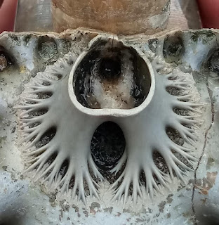
An exceptional example of the fractal building of an ammonite septum, in this clytoceratid Argonauticeras besairei from the awesome José Juárez Ruiz.

Ammonites were predatory, squidlike creatures that lived inside coil-shaped shells.

Like other cephalopods, ammonites had sharp, beak-like jaws inside a ring of squid-like tentacles that extended from their shells. 

They used these tentacles to snare prey, — plankton, vegetation, fish and crustaceans — similar to the way a squid or octopus hunt today.

Catching a fish with your hands is no easy feat, as I am sure you know. But the Ammonites were skilled and successful hunters. They caught their prey while swimming and floating in the water column. 

Within their shells, they had a number of chambers, called septa, filled with gas or fluid that were interconnected by a wee air tube. By pushing air in or out, they were able to control their buoyancy in the water column.

They lived in the last chamber of their shells, continuously building new shell material as they grew. As each new chamber was added, the squid-like body of the ammonite would move down to occupy the final outside chamber.

They were a group of extinct marine mollusc animals in the subclass Ammonoidea of the class Cephalopoda. 

These molluscs, commonly referred to as ammonites, are more closely related to living coleoids — octopuses, squid, and cuttlefish) than they are to shelled nautiloids such as the living Nautilus species.

The Ammonoidea can be divided into six orders:

  • Agoniatitida, Lower Devonian - Middle Devonian
  • Clymeniida, Upper Devonian
  • Goniatitida, Middle Devonian - Upper Permian
  • Prolecanitida, Upper Devonian - Upper Triassic
  • Ceratitida, Upper Permian - Upper Triassic
  • Ammonitida, Lower Jurassic - Upper Cretaceous

Ammonites have intricate and complex patterns on their shells called sutures. The suture patterns differ across species and tell us what time period the ammonite is from. If they are geometric with numerous undivided lobes and saddles and eight lobes around the conch, we refer to their pattern as goniatitic, a characteristic of Paleozoic ammonites.

If they are ceratitic with lobes that have subdivided tips; giving them a saw-toothed appearance and rounded undivided saddles, they are likely Triassic. For some lovely Triassic ammonites, take a look at the specimens that come out of Hallstatt, Austria and from the outcrops in the Humboldt Mountains of Nevada.

Hoplites bennettiana (Sowby, 1826) Christophe Marot
If they have lobes and saddles that are fluted, with rounded subdivisions instead of saw-toothed, they are likely Jurassic or Cretaceous. If you'd like to see a particularly beautiful Lower Jurassic ammonite, take a peek at Apodoceras. Wonderful ridging in that species.

One of my favourite Cretaceous ammonites is the ammonite, Hoplites bennettiana (Sowby, 1826). This beauty is from Albian deposits near Carrière de Courcelles, Villemoyenne, near la région de Troyes (Aube) Champagne in northeastern France.

At the time that this fellow was swimming in our oceans, ankylosaurs were strolling about Mongolia and stomping through the foliage in Utah, Kansas and Texas. Bony fish were swimming over what would become the strata making up Canada, the Czech Republic and Australia. Cartilaginous fish were prowling the western interior seaway of North America and a strange extinct herbivorous mammal, Eobaatar, was snuffling through Mongolia, Spain and England.

In some classifications, these are left as suborders, included in only three orders: Goniatitida, Ceratitida, and Ammonitida. Once you get to know them, ammonites in their various shapes and suturing patterns make it much easier to date an ammonite and the rock formation where it is found.

Ammonites first appeared about 240 million years ago, though they descended from straight-shelled cephalopods called bacrites that date back to the Devonian, about 415 million years ago, and the last species vanished in the Cretaceous–Paleogene extinction event.

They were prolific breeders that evolved rapidly. If you could cast a fishing line into our ancient seas, it is likely that you would hook an ammonite, not a fish. They were prolific back in the day, living (and sometimes dying) in schools in oceans around the globe. We find ammonite fossils (and plenty of them) in sedimentary rock from all over the world.

In some cases, we find rock beds where we can see evidence of a new species that evolved, lived and died out in such a short time span that we can walk through time, following the course of evolution using ammonites as a window into the past.

For this reason, they make excellent index fossils. An index fossil is a species that allows us to link a particular rock formation, layered in time with a particular species or genus found there. 

Generally, deeper is older, so we use the sedimentary layers of rock to match up to specific geologic time periods, rather like the way we use tree rings to date trees. A handy way to compare fossils and date strata across the globe.

References: Inoue, S., Kondo, S. Suture pattern formation in ammonites and the unknown rear mantle structure. Sci Rep 6, 33689 (2016). https://doi.org/10.1038/srep33689

https://www.nature.com/articles/srep33689?fbclid=IwAR1BhBrDqhv8LDjqF60EXdfLR7wPE4zDivwGORTUEgCd2GghD5W7KOfg6Co#citeas

Photos: Argonauticeras besairei from the awesome José Juárez Ruiz.

Photo: Hoplites bennettiana from near Troyes, France. Collection de Christophe Marot

Thursday 2 June 2022

HISTORIC STANLEY PARK: TOTEM POLES & FIRST NATION HISTORY

Totem, Welcome & Mortuary Poles at Stanley Park
If you visit Brockton Point in Stanley Park, there are many carved red cedar First Nation poles for you to admire.  

What you are viewing are replicas of First Nation welcome and totem poles that once stood in the park but have been returned to their homes within the province's diverse First Nation communities — or held within museum collections. 

Some of the original totems came from Alert Bay on Cormorant Island, near the Port McNeill on the north coast of Vancouver Island. 

Others came from communities in Haida Gwaii — and still more from the Wuikinuxv First Nations at Rivers Inlet on British Columbia's central west coast — home of the Great Bear Rainforest with her Spirit Bears.

The exception is the most recent addition carved by Robert Yelton in 2009. Robert is a First Nation carver from the Squamish Nation and his original welcome pole graces Brockton Point, the original settlement site of a group of Squamish-Portuguese settlers.  

If you look at the photo above, the lovely chocolate, red and turquoise pole on the right is a replica of the mortuary pole raised to honour the Raven Chief of Skedans or Gida'nsta, the Haida phrase for from his daughter, the title of respect used when addressing a person of high rank. Early fur traders often took the name of the local Chief and used it synonymously as the place names for the sites they visited — hence Skedans from Gida'nsta.

Chief Skedans Mortuary Pole
Chief Skedans, or Qa'gials qe'gawa-i, to his children, lived in Ḵ’uuna Llnagaay, or village at the edge, in Xaayda Kil — a village on the exposed coast of Louise Island — now a Haida Heritage Site.  

There are some paintings you may have seen by Emily Carr of her visits to the site in 1912, She used the phonetic Q'una from Q:o'na to describe both the place name and title of her work. 

Carr's paintings of the totems have always looked to me to be a mash-up — imagine if painter Tamara de Lempicka and photographer Edward Curtis had a baby — not pretty, but interesting.

Some called this area, Huadju-lanas or Xu'adji la'nas, which means Grizzly-Bear-Town, in reference to resident grizzly bear population and their adornment of many totems and artwork by the local artists.

Upon Chief Skedan's death, the mortuary pole was carved both to honour him and provide his final resting place. Dates are a bit fuzzy, but local accounts have this as sometime between 1870-1878 — and at a cost of 290 blankets or roughly $600 in today's currency. 

The great artistry of the pole was much admired by those in the community and those organizing the celebrations for the 1936 Vancouver Golden Jubilee — witnessed by  350,000 newly arrived residents.

Negotiations were pursued and the pole made its way down from Haida Gwaii to Stanley Park in time for the celebrations. The original totem graced Stanley Park for a little over twenty years before eventually making its way back to Haida Gwaii. It was returned to the community with bits of plaster and shoddy paint marring the original. These bits were scraped off and the pole welcomed back with due ceremony. 

In 1964, respected and renowned Northwest Coast master carver, Bill Reid, from the Kaadaas gaah Kiiguwaay, Raven/Wolf Clan of T'anuu, Haida Gwaii and Scottish-German descent, was asked to carve this colourful replica. 

Mountain Goat Detail, Skedans Mortuary Pole
Reid carved the totem onsite in Stanley Park with the help of German carver Werner True. Interestingly, though I looked at length for information on Werner True, all I can find is that he aided Bill Reid on the carving for a payment of $1000.

Don Yeomans, Haida master carver, meticulously recarved the moon crest in 1998. If you have admired the totem pole in the Vancouver Airport, you will have seen some of Yeoman's incredible work. 

The crest is Moon with the face, wings, legs and claws of a mighty and proud Thunderbird with a fairly smallish hooked beak in a split design. We have Moon to thank for the tides and illuminating our darkest nights. As a crest, Moon is associated with transformation and acting as both guardian and protector.

The original pole had a mortuary box that held the Chief's remains. The crest sits atop a very charming mountain goat. I have included a nice close-up here of the replica for you to enjoy. 

Mountain Goats live in the high peaks of British Columbia and being so close to the sky, they have the supernatural ability to cross over to the sky world. They are also credited as being spirit guardians and guides to First Nation shamans.

I love his horns and tucked in cloven hooves. There is another pole being carved on Vancouver Island that I hope to see during its creation that also depicts a Mountain Goat. With permission and in time, I hope to share some of those photos with you. 

Mountain Goat is sitting atop Grizzly Bear or Huaji or Xhuwaji’ with little human figures placed in his ears to represent the Chief's daughter and son-in-law, who raised the pole and held a potlatch in his honour. 

Beneath the great bear is Seal or Killer Whale in his grasp. The inscription in the park says it is a Killer Whale but I am not sure about that interpretation — both the look and lore make Seal more likely. Perhaps if Killer Whale were within Thunderbird's grasp — maybe

Though it is always a pleasure to see Killer Whale carved in red cedar, as the first whales came into being when they were carved in wood by a human — or by Raven — then magically infused with the gift of life.

Siwash Rock on the northern end of Third Beach, Stanley Park
The ground these totems sit upon is composed of plutonic, volcanic and sedimentary layers of rock and exhibits the profound influences of glaciation and glacial retreat from the last ice age. 

Glacial deposits sit atop as a mix of clay, sand, cobbles and larger boulders of glacial till. 

There are a few areas of exposed volcanics within the park that speak to the scraping of the glaciers as they retreated about 12,500 years ago. 

The iconic moss and lichen coated Siwash Rock on the northern end of Third Beach is one of the more picturesque of these. It is a basaltic and andesitic volcanic rock — a blend of black phenocrysts of augite cemented together with plagioclase, hornblende and volcanic glass.

Images not shown: 

Do check out the work of Emily Carr and her paintings of Q:o'na from the 1940s. I'll share a link here but do not have permission to post her works. http://www.emilycarr.org/totems/exhibit/haida/ssintro.htm

Thursday 12 May 2022

NEVADA FOSSILS: CARNIAN-NORIAN BOUNDARY

Time Slows at Berlin-Ichthyosaur State Park
High on the hillside up a long entry road sits the entrance to Berlin-Ichthyosaur State Park in central Nevada.

A worn American flag and sun bleached outbuildings greet you on your way to the outcrops. Away from the hustle and bustle that define the rest of Nevada this place feels remarkably serene. Your eyes squint against the sun as you search for ammonoids and other marine fossil fauna while your nose tends to the assault from the bracing smell of sage brush.

This site holds many stories. The interpretive centre displays wonderful marine reptiles, ichthyosaurs in situ, as you might expect from the name of the park — but it also showcases years of history lovingly tended. This stretch of dry golden low hills dappled with the yellow of creosote and desert grasses is an important locality for our understanding of the Carnian-Norian boundary (CNB) in North America.

The area is known worldwide as one of the most important ichthyosaur Fossil-Lagerstätte because of the sheer volume of remarkably well-preserved, fully articulated (all the sweet bones laid out all in a row...) specimens of Shonisaurus popularis.

Rich ammonoid faunas outcrop in the barren hills of the Upper Triassic (Early Norian, Kerri zone), Luning Formation, West Union Canyon, Nevada. They were studied by N. J. Silberling (1959) and provide support for the definition of the Schucherti and Macrolobatus zones of the latest Carnian — which are here overlain by well-preserved faunas of the earliest Norian Kerri Zone. 

The genus Gonionotites, very common in the Tethys and British Columbia, is for the moment, unknown in Nevada. The Upper Carnian faunas are dominated by Tropitidae, while Juvavitidae are conspicuously lacking. 

Middle Triassic Ammonoids
Despite its importance, no further investigations had been done at this site for a good 50 years. That changed in 2010 when Jim Haggart, Mike Orchard and Paul Smith — all local Vancouverites — collaborated on a project that took them down to Nevada to look at the conodonts and ammonoids. They did a bed-by-bed sampling of ammonoids and conodonts in West Union Canyon during October of that year.

October is an ideal time to do fieldwork in this area. There are a few good weeks between screaming hot and frigid cold. It is also tarantula breeding season so keep your eyes peeled. Those sweet little burrows you see are not from rodents but rather largish arachnids. 

The eastern side of the canyon provides the best record of the Macrolobatus Zone, which is represented by several beds yielding ammonoids of the Tropites group, together with Anatropites div. sp. 

Conodont faunas from both these and higher beds are dominated by ornate metapolygnthids that would formerly have been collectively referred to Metapolygnathus primitius, a species long known to straddle the CNB. Within this lower part of the section, they resemble forms that have been separated as Metapolygnathus mersinensis. Slightly higher, forms close to Epigondolella' orchardi and a single Orchardella n. sp. occur. This association can be correlated with the latest Carnian in British Columbia.

Higher in the section, the ammonoid fauna shows a sudden change and is dominated by Tropithisbites. Few tens of metres above, but slightly below the first occurrence of Norian ammonoids Guembelites jandianus and Stikinoceras, two new species of conodonts (Gen et sp. nov. A and B) appear that also occur close to the favoured Carnian/Norian boundary at Black Bear Ridge, British Columbia. Stratigraphically higher collections continue to be dominated by forms close to M. mersinensis and E. orchardi after BC's own Mike Orchard.

The best exposure of the Kerri Zone is on the western side of the West Union Canyon. Ammonoids, dominated by Guembelites and Stikinoceras div. sp., have been collected from several fossil-bearing levels. Conodont faunas replicate those of the east section. The collected ammonoids fit perfectly well with the faunas described by Silberling in 1959, but they differ somewhat from coeval faunas of the Tethys and Canada. 

The ammonoid fauna paints a compelling picture of Tethyan influence with a series of smoking guns. We see an abundance of Tropitidae in the Carnian, a lack of Pterosirenites in the Norian, copious Guembelites, the Tethyan species G. philostrati, the stratigraphic position of G. clavatus and the rare occurrence of Gonionotites. Their hallelujah moment was likely finding an undescribed species of the thin-shelled bivalve Halobia similar to Halobia beyrichi — the clincher that perhaps seals this deal on Tethyan influence. 

I'll take a boo to see what Christopher McRoberts published on the find. A jolly good idea to have him on this expedition as it would have been easy to overlook if the focus remained solely on the conodonts and ammonoids. McRoberts has published on the much-studied Pardonet Formation up in the Willison Lake Area of Northeastern, British Columbia. He knows a thing or two about Upper Triassic Bivalvia and the correlation to coeval faunas elsewhere in the North American Cordillera, and to the Boreal, Panthalassan and Tethyan faunal realms. 

If you fancy a read, they published a paper: "Towards the definition of the Carnian/Norian Boundary: New data on Ammonoids and Conodonts from central Nevada," which you can find in the proceedings of the 21st Canadian Paleontology Conference; by Haggart, J W (ed.); Smith, P L (ed.); Canadian Paleontology Conference Proceedings no. 9, 2011 p. 9-10.

Fig. 1. Location map of Berlin-Ichthyosaur State Park

Marco Balini, James Jenks, Riccardo Martin, Christopher McRoberts, along with Mike Orchard and Norman Siberling, did a bed by bed sampling in 2013 and published on The Carnian/Norian boundary succession at Berlin-Ichthyosaur State Park (Upper Triassic, central Nevada, USA) and published in January 2014 in Paläontologische Zeitschrift 89:399–433. That work is available for download from ResearchGate. The original is in German, but there is a translation available.

After years of reading about the correlation between British Columbia and Nevada, I had the very great pleasure of walking through these same sections in October 2019 with members of the Vancouver Paleontological Society and Vancouver Island Palaeontological Society. It was with that same crew that I'd originally explored fossil sites in the Canadian Rockies in the early 2000s. Those early trips led to paper after paper and the exciting revelations that inspired our Nevada adventure.

If you plan your own adventure, you'll want to keep an eye out for some of the other modern fauna — mountain lions, snakes, lizards, scorpions, wolves, coyotes, foxes, ground squirrels, rabbits, falcons, hawks, eagles, bobcats, sheep, deer and pronghorns.

Figure One: Location map of Berlin-Ichthyosaur State Park. A detailed road log with access information for this locality is provided in Lucas et al. (2007).

Tuesday 26 April 2022

BITS OF HISTORY: SALMON CANNERIES IN BRITISH COLUMBIA

This weathered red building perched atop rotting pilings and nestled within British Columbia's rugged wilderness is the Tallheo Cannery off Vancouver Island's north coast. 

It is abandoned today but was once a prosperous salmon cannery on Canada's rugged west coast processing local Chinook, Pink, Chum, Sockeye and Spring salmon from fishing boats offloading their catch from the frigid waters of the Pacific Ocean.

Tallheo is also the location of a former village of the Nuxalk First Nations known as Talyu. It sits at the junction of the Taleomy and Noerick Rivers where they join South Bentinck Arm at Taleomy Narrows. 

Today, you can visit the site and stay at the local Tallheo Cannery Guest House which operates as a bed and breakfast, offering visitors a chance to see the original cannery, general store and enjoy the moody weather of the north coast.

While many associate Tallheo with its cannery history is also the name of the dialect of the Nuxalk language spoken by the Talhyumc, the subgroup of the Nuxalk Nation who live here and by those who live at Q'umk'uts' at the confluence of the Bella Coola River and the Pacific Ocean in the Bella Coola Valley. The Nuxalk are a distinct people of the area and decidedly not Coast Salish as some report. 

Prior to European contact, they numbered more than 35,000 strong. Once smallpox and conflict had taken their toll, that number dwindled to a tragic 300.

Over the past hundred years, that population has rebounded to 3,000 and growing — a testament to their strength and endurance as a people and commitment to family, land and prosperity. 

In 1905, the Tallheo Cannery opened to the hum and thrum of modern machinery mixed with skilled human hands to process the marine bounty of the local area. The business was founded by a Norwegian immigrant who employed many of the local residents. 

The fish were caught up on the west coast, processed locally by a mix of settler and First Nation workers then exported to the world to share in the modern convenience of tinned salmon.  What a pleasure it must have been for some folk to try this west coast delicacy and chiefly fish some for the first time. The canning process had been around since the early 1800s, first developed in France then spreading across Europe before coming to North America. Canned meat was originally available in crocks, glass, and tinned iron and found its first use as a means to keep the troups fed for the European military. 

British Columbia welcomed the first canneries in the 1860s. The industry soon became the bread and butter for many local families and allowed those far from the coast and indeed, across the seas, to dine on fresh-caught salmon. 

At one time, British Columbia boasted more than 200 such canneries. Over the years all have shut down — save one. St. Jean's Cannery and Smokehouse in Nanaimo is all that remains of this one booming industry. 

St. Jean's got their start selling smoked oysters or smudgies to locals, then expanded to chowder and finally salmon. They were a family favourite of ours growing up on the coast. 

Both my Uncle Dick and Uncle Doug sold them oysters and fish that were quickly turned into delectable oyster chowder and canned salmon that were sold for 25 cents each. Today, they sell hand-packed wild Pacific salmon, tuna and shellfish in their online store and process fresh-caught salmon from sport fishermen. 

Wild, smoked Pink salmon and wild, skinless, boneless Sockeye salmon will run you $5.95 per tin and wild smoked sockeye a few pennies more at $6.50. They also sell candied salmon, a personal favourite of mine, for $7.95-$27.95 in sealed foil pouches. 

The expansion in products led to an expansion of the business itself. St. Jean's is now in Port Alberni on Vancouver Island, a fitting local as this community is known as the Salmon Capital of the World, and Delta along the Fraser Lowland south of the Fraser River in British Columbia's Lower Mainland. 

It would be wonderful to see this industry grow even further to bring back the cannery traditions to British Columbia's wild west coast and the bounty found here.

  • References: http://nuxalk.net
  • St. Jean's Cannery and Smokehouse: https://stjeans.com
  • Tallheo Cannery Guest House: https://www.bellacoolacannery.com
  • Alaska Historical Society: https://alaskahistoricalsociety.org/history-in-a-can-2
  • The Tyee: https://thetyee.ca/Solutions/2018/08/22/Last-BC-Cannery-Standing/