Friday, 24 February 2023

SHUSWAP NATION FOSSIL BEDS

The McAbee Fossil Beds are known for their incredible abundance, diversity and quality of fossils including lovely plant, insect and fish species that lived in an old lake bed setting 52-53 million years ago.

It is one of the best local sites in the province to experience a fossil dig first-hand. It's an easy 4-hour drive from Vancouver and easily done as a rather longish day trip. I headed up this past summer with some wonderful enthusiastic crew to see how things were progressing with its development.

The site was designated a Provincial Heritage Site under British Columbia's Heritage Conservation Act in July of 2012. The site was reopened to public tours and viewing this summer with plans to build out a visitor's centre and educational programs in the future.

We were greeted on the day by two wonderful hosts from the Bonaparte Band, Gayle Pierro and Leroy Antoine. Both were very welcoming and informative, sharing the lay of the land, a bit of their history with the workings and offering us a guided tour. 

From the road, it is a short drive up to the first staging area that houses visitor parking and a public washroom. The first Site Information station is a short stroll away and includes a tent with a table and maps showing plans for the site. Here, Gayle walked us through the vision for McAbee and showed us a selection of some of the species found here. 

We were asked to stop back on the way down and fill out a survey that asked about our experience and provide feedback that will help shape what McAbee is to become. A short hike up the hill towards the hoodoos leads to another staging area. Here, Leroy was our host and guide. He shared a bit more about the geology of the area and showed us specimens found over the summer.

As McAbee is a Heritage Site, their only request was that we stay within the marked area and trails and keep ourselves safe. Here safe means hydrated, shaded from the sun and avoiding both the resident rattlesnakes and cacti. McAbee offers an excellent opportunity for education and outreach both for locals and the larger community. It was very enjoyable to see the reactions of those visiting the site as they took in the wonderful diversity of fossil species and learning about the local history from our hosts.

The Province is committed to providing access to the site to scientists and the lay public. The direction on what happens next at McAbee is being driven by the Heritage Branch in consultation with members of the Shuswap Nation and Bonaparte Band. Bonaparte's traditional territory is located within the Shuswap Nation and includes the site where the McAbee Fossil Beds are situated. 

Local members of the Bonaparte Band are Secwepemc. They would like to share the spiritual significance of the area from a Secwepemc First Nation perspective and see McAbee as an indigenous tourism destination. So it looks like it will be paleontology, archaeology with a cultural focus to add spice. In any case, fossil viewing, and hopefully supervised collecting will continue with oversight to ensure significant fossil finds make their way to science.

It would be good to see McAbee take a page out of the Courtney and District Museum's playbook. You'll recall that it was the Puntledge Elasmosaur that sparked the expansion of that museum and inspired a whole host of outreach and educational programs. The Courtenay Museum has been offering paid guided tours to the elasmosaur heritage site for over a dozen years. 

They are members of the British Columbia Paleontological Alliance (BCPA), a union of professional and amateur paleontological organizations working to advance the science of paleontology in the province by fostering public awareness, scientific collecting and education, and by promoting communication among all those interested in fossils. Within that context, the Courtenay Museum are bound both by the BCPA constitution and bylaws, and of course, the laws around fossil collecting in British Columbia.

One of the sister sites to McAbee, the Driftwood Canyon Provincial Park Fossil Beds, offers an honours system for their site. Visitors may handle and view fossils but are asked to not take them home. Both Driftwood Canyon and McAbee are part of an arc of Eocene lakebed sites that extend from Smithers in the north, down to the fossil site of Republic Washington, in the south. The grouping includes the fossil sites of Driftwood Canyon, Quilchena, Allenby, Tranquille, McAbee, Princeton and Republic. Each of these localities provides important clues to our ancient climate.

The fossils range in age from Early to Middle Eocene. McAbee had a more temperate climate, slightly cooler and wetter than other Eocene sites to the south at Princeton, British Columbia, Republic in north-central Washington, in the Swauk Formation near Skykomish and the Chuckanut Formation of northern Washington state. The McAbee fossil beds consist of 30 metres of fossiliferous shale in the Eocene Kamloops Group.

The fossils are preserved here as impressions and carbonaceous films. We see gymnosperm (16 species); a variety of conifers (14 species to my knowledge); two species of ginkgo, a large variety of angiosperm (67 species); a variety of insects and fish remains, the rare feather and a boatload of mashed deciduous material. Nuts and cupules are also found from the dicotyledonous Fagus and Ulmus and members of the Betulaceae, including Betula and Alnus.

We see many species that look very similar to those growing in the Pacific Northwest today. Specifically, cypress, dawn redwood, fir, spruce, pine, larch, hemlock, alder, birch, dogwood, beech, sassafras, cottonwood, maple, elm and grape. If we look at the pollen data, we see over a hundred highly probable species from the site. Though rare, McAbee has also produced spiders, birds (and lovely individual feathers) along with multiple specimens of the freshwater crayfish, Aenigmastacus crandalli.

For insects, we see dragonflies, damselflies, cockroaches, termites, earwigs, aphids, leafhoppers, spittlebugs, lacewings, a variety of beetles, gnats, ants, hornets, stick insects, water striders, weevils, wasps and March flies. The insects are particularly well-preserved. Missing are the tropical Sabal (palm), seen at Princeton and the impressive Ensete (banana) and Zamiaceae (cycad) found at Eocene sites in Republic and Chuckanut, Washington.

McAbee is located just east of Cache Creek, just north of and visible from Highway 1/97. 14.5 km to be exact and exactly the distance you need to drink one large coffee and then need a washroom. You'll be pleased to know they have installed one at the site. McAbee is a site for hiking boots, hand, head and eye protection. They have a few resident rattlesnakes and prickly cacti to keep you on your toes. Keep yourself safe and well-hydrated. There will be someone to greet you and let you know if it is open to collecting or if you'll have to satisfy yourself by enjoying their interpretive offerings.

As you drive up, you'll see telltale hoodoos on the ridge to let you know you've reached the right spot. If you have a GPS, pop in these coordinates and you're on your way. 50°47.831′N 121°8.469′W.

Thursday, 23 February 2023

14TH BC PALAEONTOLOGICAL SYMPOSIUM

You will be delighted to know that it is time for the next BCPA Symposium, June 9th - 12th, 2023. 

This is the 14th BC Palaeontological Symposium and it will be hosted by the Victoria Palaeontology Society along with the School of Earth and Ocean Sciences (SEOS), University of Victoria (UVic); Royal British Columbia Museum (RBCM); and, BC Fossil Management Office.

The 2023 BCPA conference is being held at the Bob Wright Centre, University of Victoria, Victoria, BC. I'll post a wee map here to make finding all this goodness a wee bit easier. The Bob Wright Centre (BWC) is just a short walk from Bento Sushi and SciCafé near UVic Parking Lot B.

Keynote Speakers: Dr. Jean-Bernard Caron & Dr. Charles Helm

The Burgess Shale Fossil Deposit of Marble Canyon in Kootenay National Park: Retrospective of the Last 10 Years of Research. In Southeastern BC, the Burgess Shale is the internationally renowned site that keeps on giving.  Symposium 2023 welcomes you on a journey through the past decade, featuring the field research and expertise of:

Dr. Jean-Bernard Caron, Richard M. Ivey Curator of Invertebrate Palaeontology at the Royal Ontario Museum, Toronto.

Dr. Caron leads regular fieldwork activities to the Canadian Rockies primarily to study how the Burgess Shale biota changed through space and time in response to ecological, evolutionary and environmental factors. Field-based research is an important aspect of his work and his research lab primarily focuses on fossilization processes, ecology, phylogeny, and diversity of Burgess Shale animals.

Tracking vertebrates from two eras on two continents—Northern BC is home to our second keynote speaker, Dr. Charles Helm, who is trekking two continents in search of tracks. 

Dr. Charles Helm, Research Associate at the Tumbler Ridge Museum and at the African Centre for Coastal Palaeoscience, Nelson Mandela University, South Africa is currently pursuing his PhD in paleontology in the Department of Geoscience, Nelson Mandela University, South Africa.

His paleontological research interests are in Pleistocene vertebrate tracks in South Africa (including hominin tracks and traces) and Cretaceous vertebrate tracks in northern British Columbia.  

Many of you will know Dr. Helm as founder of the Tumbler Ridge Museum Foundation in 2002. He developed the proposal that led to the creation of the Tumbler Ridge UNESCO Global Geopark in 2014, and was its first President.

BCPA Conference Link: https://vicpalaeo.org/.../14th-bc-palaeontological.../...
BCPA Website: www.bcfossils.ca

Here is a handy dandy map for easy reference:


Tuesday, 21 February 2023

NOOTKA FOSSIL AND FIRST NATIONS HISTORY

Nootka Fossil Field Trip. Photo: John Fam
The rugged west coast of Vancouver Island offers spectacular views of a wild British Columbia. Here the seas heave along the shores slowly eroding the magnificent deposits that often contain fossils. 

Just off the shores of Vancouver Island, east of Gold River and south of Tahsis is the picturesque and remote Nootka Island.

This is the land of the proud and thriving Nuu-chah-nulth First Nations who have lived here always

Always is a long time, but we know from oral history and archaeological evidence that the Mowachaht and Muchalaht peoples lived here, along with many others, for many thousands of years — a time span much like always

While we know this area as Nootka Sound and the land we explore for fossils as Nootka Island, these names stem from a wee misunderstanding. 

Just four years after the 1774 visit by Spanish explorer Juan Pérez — and only a year before the Spanish established a military and fur trading post on the site of Yuquot — the Nuu-chah-nulth met the Englishman, James Cook.  

Captain Cook sailed to the village of Yuquot just west of Vancouver Island to a very warm welcome. He and his crew stayed on for a month of storytelling, trading and ship repairs. Friendly, but not familiar with the local language, he misunderstood the name for both the people and land to be Nootka. In actual fact, Nootka means, go around, go around

Two hundred years later, in 1978, the Nuu-chah-nulth chose the collective term Nuu-chah-nulth — nuučaan̓uł, meaning all along the mountains and sea or along the outside (of Vancouver Island) — to describe themselves. 

It is a term now used to describe several First Nations people living along western Vancouver Island, British Columbia. 

It is similar in a way to the use of the United Kingdom to refer to the lands of England, Scotland and Wales — though using United Kingdom-ers would be odd. Bless the Nuu-chah-nulth for their grace in choosing this collective name.  

An older term for this group of peoples was Aht, which means people in their language and is a component in all the names of their subgroups, and of some locations — Yuquot, Mowachaht, Kyuquot, Opitsaht. While collectively, they are the Nuu-chah-nulth, be interested in their more regional name should you meet them. 

But why does it matter? If you have ever mistakenly referred to someone from New Zealand as an Aussie or someone from Scotland as English, you have likely been schooled by an immediate — sometimes forceful, sometimes gracious — correction of your ways. The best answer to why it matters is because it matters.

Each of the subgroups of the Nuu-chah-nulth viewed their lands and seasonal migration within them (though not outside of them) from a viewpoint of inside and outside. Kla'a or outside is the term for their coastal environment and hilstis for their inside or inland environment.

It is to their kla'a that I was most keen to explore. Here, the lovely Late Eocene and Early Miocene exposures offer up fossil crab, mostly the species Raninid, along with fossil gastropods, bivalves, pine cones and spectacularly — a singular seed pod. These wonderfully preserved specimens are found in concretion along the foreshore where time and tide erode them out each year.

Five years after Spanish explorer Juan Pérez's first visit, the Spanish built and maintained a military post at Yuquot where they tore down the local houses to build their own structures and set up what would become a significant fur trade port for the Northwest Coast — with the local Chief Maquinna's blessing and his warriors acting as middlemen to other First Nations. 

Following reports of Cook's exploration British traders began to use the harbour of Nootka (Friendly Cove) as a base for a promising trade with China in sea-otter pelts but became embroiled with the Spanish who claimed (albeit erroneously) sovereignty over the Pacific Ocean. 

Dan Bowen searching an outcrop. Photo: John Fam
The ensuing Nootka Incident of 1790 nearly led to war between Britain and Spain (over lands neither could actually claim) but talk of war settled and the dispute was settled diplomatically. 

George Vancouver on his subsequent exploration in 1792 circumnavigated the island and charted much of the coastline. His meeting with the Spanish captain Bodega y Quadra at Nootka was friendly but did not accomplish the expected formal ceding of land by the Spanish to the British. 

It resulted however in his vain naming the island "Vancouver and Quadra." The Spanish captain's name was later dropped and given to the island on the east side of Discovery Strait. Again, another vain and unearned title that persists to this day.

Early settlement of the island was carried out mainly under the sponsorship of the Hudson's Bay Company whose lease from the Crown amounted to 7 shillings per year — that's roughly equal to £100.00 or $174 CDN today. Victoria, the capital of British Columbia, was founded in 1843 as Fort Victoria on the southern end of Vancouver Island by the Hudson's Bay Company's Chief Factor, Sir James Douglas. 

With Douglas's help, the Hudson's Bay Company established Fort Rupert on the north end of Vancouver Island in 1849. Both became centres of fur trade and trade between First Nations and solidified the Hudson's Bay Company's trading monopoly in the Pacific Northwest.

The settlement of Fort Victoria on the southern tip of Vancouver Island — handily south of the 49th parallel — greatly aided British negotiators to retain all of the islands when a line was finally set to mark the northern boundary of the United States with the signing of the Oregon Boundary Treaty of 1846. Vancouver Island became a separate British colony in 1858. British Columbia, exclusive of the island, was made a colony in 1858 and in 1866 the two colonies were joined into one — becoming a province of Canada in 1871 with Victoria as the capital.

Dan Bowen, Chair of the Vancouver Island Palaeontological Society (VIPS) did a truly splendid talk on the Fossils of Nootka Sound. With his permission, I have uploaded the talk to the ARCHEA YouTube Channel for all to enjoy. Do take a boo, he is a great presenter. Dan also graciously provided the photos you see here. The last of the photos you see here is from the August 2021 Nootka Fossil Field Trip. Photo: John Fam, Vice-Chair, Vancouver Paleontological Society (VanPS).

Know Before You Go — Nootka Trail

The Nootka Trail passes through the traditional lands of the Mowachaht/Muchalat First Nations who have lived here since always. They share this area with humpback and Gray whales, orcas, seals, sea lions, black bears, wolves, cougars, eagles, ravens, sea birds, river otters, insects and the many colourful intertidal creatures that you'll want to photograph.

This is a remote West Coast wilderness experience. Getting to Nootka Island requires some planning as you'll need to take a seaplane or water taxi to reach the trailhead. The trail takes 4-8 days to cover the 37 km year-round hike. The peak season is July to September. Permits are not required for the hike. 

Access via: Air Nootka floatplane, water taxi, or MV Uchuck III

  • Dan Bowen, VIPS on the Fossils of Nootka: https://youtu.be/rsewBFztxSY
  • https://www.thecanadianencyclopedia.ca/en/article/sir-james-douglas
  • file:///C:/Users/tosca/Downloads/186162-Article%20Text-199217-1-10-20151106.pdf
  • Nootka Trip Planning: https://mbguiding.ca/nootka-trail-nootka-island/#overview


Monday, 20 February 2023

UNESCOCERATOPS KOPPELHUSAE BY JULIUS CSOTONYI

Unescoceratops koppelhusae, Julius Csotonyi
A very sweet small leptoceratopsid dinosaur, Unescoceratops koppelhusae — a new species in the collections of the Royal Tyrrell Museum of Palaeontology in Drumheller, Alberta.

The colourful and beautifully detailed painting you see here is by the very talented Julius Csotonyi who captured the magnificence of form, texture and palette to bring this small leptoceratopsid dinosaur to life.

The Royal Tyrrell Museum of Palaeontology, named in honour of Joseph Burr Tyrrell, is a palaeontology museum and research facility in Drumheller, Alberta, Canada. 

This jaw is the holotype specimen of this small leptoceratopsid dinosaur. Only a handful of isolated fossils have been found from this species, including a jaw that is the holotype specimen now in collections at the Royal Tyrell. 

The Royal Tyrrell Museum of Palaeontology, named in honour of Joseph Burr Tyrrell, is a palaeontology museum and research facility in Drumheller, Alberta, Canada. 

Unescoceratops koppelhusae, RTMP Collections
The rusty chocolate jaw bone you see here is the puzzle piece that helped all of the research come together and help us to better understand more about the diminutive leptoceratopsid dinosaurs from Alberta. 

The Cleveland Museum of Natural History's Michael Ryan and David Evans of the Royal Ontario Museum in Toronto recently determined that the specimen was a new genus and species. 

Unescoceratops is a genus of leptoceratopsid ceratopsian dinosaurs known from the Late Cretaceous (about 76.5-75 million years ago) of Alberta, Canada. Unescoceratops is thought to have been between one and two meters long and less than 91 kilograms. A plant-eater, its teeth were the roundest of all Leptocertopsids.

Dinosaur Provincial Park, Alberta, Canada
The genus name acknowledges the UNESCO  World Heritage Site, Dinosaur Provincial Park, where the fossil was found. 

In addition to its particularly beautiful scenery, Dinosaur Provincial Park – located at the heart of the province of Alberta's badlands – is unmatched in terms of the number and variety of high-quality specimens.

To date, they represent more than 44 species, 34 genera and 10 families of dinosaurs, dating back 75-77 million years. This provides us with remarkable insight into life millions of years ago.

The park contains exceptional riparian habitat features as well as badlands of outstanding aesthetic value.

The creamy honey, beige and rust coloured hills around the fossil locality are outstanding examples of major geological processes and fluvial erosion patterns in semi-arid steppes — think glorious! 

The scenic badlands stretch along 26 kilometres of high quality and virtually undisturbed riparian habitat, presenting a landscape of stark but exceptional natural beauty.

The species name honours Dr. Eva Koppelhus, who has made significant contributions to vertebrate palaeontology and palynology. 

The genus is named to honour the UNESCO World Heritage Site designation for the locality where the specimen was found and from the Greek “ceratops,” which means 'horned face'. 

Dr Michael Ryan explained that he meant to honour UNESCO's efforts to increase understanding of natural history sites around the world.

© Julius T. Csotonyi An illustration of Unescoceratops koppelhusae, a plant-eating dinosaur from the Late Cretaceous period that lived approximately 75 million years ago shared with his gracious permission. 

ABOUT THE ARTIST

Dr. Julius Csotonyi is a Vancouver-based scientific illustrator and natural history fine artist. He is a featured paleoartist on Season One and Season Two of BC's Fossil Bounty. Julius has a scientific background in ecology (MSc) and microbiology (PhD) which has taken him to study sensitive ecosystems, from sand dunes in the Rocky Mountain parks to hydrothermal vents at the bottom of the Pacific Ocean. 

These experiences have fuelled his strong resolve to work toward preserving our Earth’s biota. Painting biological subjects is one means that he uses to both enhance public awareness of biological diversity and to motivate concern for its welfare.   

He paints murals and panels that have appeared in numerous museums including the Smithsonian’s National Museum of Natural History, press release images for scientific publications, books, stamp sets — including the outstanding 2018 “Sharks of Canada” set for Canada Post — and coins for the Royal Canadian Mint. To view more of Julius Csotonyi's exquisite work visit: https://csotonyi.com/

Sunday, 19 February 2023

COLINOCERAS TARRANTENSE

Previously Calycoceras Tarrantense, this ammonite is now called Conlinoceras tarrantense after J.P. Conlin, a famous early 20th-century fossil collector from Texas, USA.

Ammonite expert Bill Cobban used this collection to describe many Texas Cretaceous ammonites species including this species from Tarrant County, Arlington, Texas.

He was a surveyor by training and kept incredibly detailed notes on the context of his fossils.

Conlin donated his collection to the USGS and we have learned much by studying it along with other specimens from the Lone Star State. Almost a quarter of Texas is covered by Cretaceous strata, much of it fossiliferous. If we stepped back 95 million years, the world and what we now call Texas was a very different place.

95 million years ago, during the Late Cretaceous, a shallow seaway separated North America into separate eastern and western landmasses. We have a pretty complete picture in the fossil record of the western groups of species but relatively little in comparison to their cohorts in the east.

At the time this fellow was swimming our ancient seas, he was sharing the Earth with carnivorous dinosaurs, duck-billed dinosaurs, mammals, crocodilians, turtles, a variety of amphibians, prehistoric bony fish, oddly prolific sea cucumbers, various invertebrates and plants. Many of these sites are just being written up now and contain new species just being discovered.

During the Late Cretaceous Period, a shallow seaway separated North America into separate eastern and western landmasses. The Woodbine Formation in Texas preserves a rare fossil record of this time for the east, but many of these fossils are isolated and incomplete, making interpretations more difficult. Preliminary excavations at the Arlington Archosaur Site (AAS) are providing hints at a more complete ecosystem, preserving similar patterns of change to what we see in the west.

The Arlington Archosaur site contains an extraordinary diversity, abundance, and quality of fossil material, preserving one of the most complete terrestrial ecosystems known for this time period and area.

These outcrops and the fossils they contain have a lot to tell us about Late Cretaceous life in the east. Over 2200 individual specimens have been found belonging to numerous groups including carnivorous dinosaurs, duck-billed dinosaurs, crocodilians, turtles, mammals, amphibians, sharks, bony fish, invertebrates, and plants.

Many of the fossils found here represent brand new species and studying these fossils will help to establish the geographic and environmental forces that shaped Cretaceous ecosystems in North America by providing a necessary comparison to the fossil record of the west.

Saturday, 18 February 2023

DANCERS OF THE DEEP: JELLYFISH

This lovely ocean dancer with her long delicate tentacles or lappets and thicker rouched oral arms is a jellyfish. 

Her brethren are playing in the waters of the deep all over the world, from surface waters to our deepest seas — and they are old. They are some of the oldest animals in the fossil record.

Jellyfish and sea jellies are the informal common names given to the medusa-phase or adult phase of certain gelatinous members of the subphylum Medusozoa, a major part of the phylum Cnidaria — more closely related to anemones and corals.

Jellyfish are not fish at all. They evolved millions of years before true fish. The oldest conulariid scyphozoans appeared between 635 and 577 million years ago in the Neoproterozoic of the Lantian Formation, a 150-meter-thick sequence of rocks deposited in southern China. 

Others are found in the youngest Ediacaran rocks of the Tamengo Formation of Brazil, c. 505 mya, through to the Triassic. Cubozoans and hydrozoans appeared in the Cambrian of the Marjum Formation in Utah, USA, c. 540 million years ago.

I have seen all sorts of their brethren growing up on the west coast of Canada. I have seen them in tide pools, washed up on the beach and swam amongst thousands of Moon Jellyfish while scuba diving in the Salish Sea. Their movement in the water is marvellous.  

In the Kwak̓wala language of the Kwakiutl or Kwakwaka'wakw, speakers of Kwak'wala, of the Pacific Northwest, jellyfish are known as ǥaǥisama.

The watercolour ǥaǥisama you see here in dreamy pink and white is but one colour variation. They come in blue, purple, orange, yellow and clear — and are often luminescent. They produce light by the oxidation of a substrate molecule, luciferin, in a reaction catalyzed by a protein, luciferase.

Friday, 17 February 2023

SPLIT SAIL SPINOSAURID

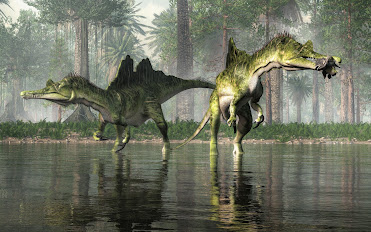
Back in the Cretaceous in what is now the heart of the Indochinese Peninsula, a group of mighty spinosaur with an unusual split sail were playing and hunting in the local waters. 

Picture an alligator whose legs grew especially long, add a big split sail on his back and arms that could grasp. That's kind of what these big therapod dinosaurs looked like.

The first fossil remains of Ichthyovenator were found in 2010 at Ban Kalum in the Grès Supérieurs Formation of the Savannakhet Basin in Savannakhet Province in the province of Laos. We have found other fossil remains at the site including fossil fish, iguanodontians and some compelling sauropod and ornithopod tracks.

Dinosaur remains are among the fossils that have been recovered from the formation. It is equivalent to the Khok Kruat Formation of northeastern Thailand, a fluvial formation similar in age. 

The Khok Kruat Formation is a treasure trove of fossil goodies as well. We have found the remains of fossil sharks, fish, turtles, crocodilians and pterosaurs. Phuwiangosaurus-like teeth, Siamosaurus teeth, and fragmentary postcranial remains of spinosaurids have been dug up there. We have also found Fukuiraptor-like teeth—and, being close in age, they are both Albian, it is likely just a matter of time before we find Ichthyovenator bones there as well.

Ichthyovenator had a long, shallow snout and robust forelimbs. Its diet likely mainly consisted of aquatic prey, hence its etymology. Spinosaurids are also known to have eaten small dinosaurs and pterosaurs in addition to fish. 

Ichthyovenator's conspicuous split sail might have been used for sexual display or species recognition. Fossil evidence suggests spinosaurids, especially spinosaurines, were adapted for semiaquatic lifestyles. The vertebral spines of Ichthyovenator's tail were unusually tall, suggesting—as in today's crocodilians—the tail may have aided in swimming. Ichthyovenator lived alongside sauropod and ornithopod dinosaurs, as well as bivalves, fish and turtles.

These fossilized bones were recovered from a red sandstone layer within a surface area of less than 2 square metres (22 sq ft). 

So, what did we find? So many great bits and pieces of these giant beasts as a massive jigsaw puzzle. Gathered together, they have been designated under the specimen numbers MDS BK10-01 to 15. There is a partly articulated, well-preserved skeleton. Sadly, missing are the skull and limbs. In with the bits and pieces were the third-to-last dorsal (back) vertebra, the neural spine of the last dorsal vertebra, five partial sacral (hip) vertebrae, the first two caudal (tail) vertebrae, both ilia (main hip bones), a right pubis (pubic bone), both ischia (lower and rearmost hip bones) and a posterior dorsal rib. 

The twelfth dorsal spine is bent sideways when viewed front-to-back due to taphonomic distortion. The central (vertebral bodies) of the sacrals are largely incomplete due to erosion but preserved all of their accompanying spines with their upper edges intact. 

At the time of Ichthyovenator's description, excavations at the site were still ongoing. Cast fossil spinal column laid out inside a glass display case at a museum Casts of the vertebrae at the Muséum National d'Histoire Naturelle, Paris After undergoing preparation in 2011, the skeleton was used as the basis, or holotype, for the type species Ichthyovenator laosensis, which was named and described in 2012 by palaeontologists Ronan Allain, Tiengkham Xeisanavong, Philippe Richir, and Bounsou Khentavong. 

The generic name is derived from the Old Greek word ἰχθύς (ichthys), "fish", and the Latin word venator, "hunter", in reference to its likely piscivorous or fish-eating lifestyle. The specific name refers to its provenance in Laos.

Ichthyovenator is the third named spinosaurid dinosaur from Asia after the Thai genus Siamosaurus in 1986 and the Chinese species "Sinopliosaurus" fusuiensis in 2009. The latter may represent the same animal as Siamosaurus

In 2014, Allain published a conference paper on Ichthyovenator; the abstract indicated additional remains from the original individual had been found after excavations continued in 2012. These remains include three teeth, the left pubis, and many vertebrae, including a nearly complete neck, the first dorsal vertebra, and seven more caudal vertebrae.

Some of these additional vertebrae were compared with those of other spinosaurids in a 2015 paper by German palaeontologist Serjoscha Evers and colleagues, in which they noted similarities with the vertebrae of the African spinosaurid Sigilmassasaurus

Allain and his team considered Ichthyovenator as representing the first unequivocal spinosaurid from Asia. Though prior spinosaurids had been named from the continent—including Siamosaurus from Thailand's Barremian Sao Khua Formation and "Sinopliosaurus" fusuiensis from China's Aptian Xinlong Formation—the authors noted that palaeontologists have debated the validity of these taxa because they are only confidently known from isolated teeth. 

Brazilian palaeontologists Marcos Sales and Caesar Schultz have suggested these teeth may eventually be attributed to spinosaurids similar to Ichthyovenator. In addition to tooth fossils, a spinosaurid skeleton that possibly belongs to Siamosaurus was excavated from the Thai Khok Kruat Formation in 2004 and was identified as a definite spinosaur in a 2008 conference abstract by Angela Milner and colleagues, eight years before Ichthyovenator's description.

Thursday, 16 February 2023

BLUE JAY: KWASK'WAS

If you live in North American, there is a high probability that you have seen or heard the bird song of the Blue jay, Cyanocitta cristata (Linnaeus, 1758).

Blue Jays are in the family Corvidae — along with crows, ravens, rooks, magpies and jackdaws. They belong to a lineage of birds first seen in the Miocene — 25 million years ago. 

These beautifully plumed, blue, black and white birds can be found across southern Canada down to Florida. The distinctive blue you see in their feathers is a trick of the light. Their pigment, melanin, is actually a rather dull brown. The blue you see is caused by scattering light through modified cells on the surface of the feather as wee barbs.

Blue jays like to dine on nuts, seeds, suet, arthropods and some small vertebrates. 

If you are attempting to lure them to your yard with a bird feeder, they prefer those mounted on trays or posts versus hanging feeders. They will eat most anything you have on offer but sunflower seeds and peanuts are their favourites. 

They have a fondness for acorns and have been credited with helping expand the range of oak trees as the ice melted after the last glacial period.  

Their Binomial name, Cyanocitta cristata means, crested, blue chattering bird. I might have amended that to something less flattering, working in a Latin word or two for shrieks and screams — voce et gemitu or ululo et quiritor. While their plumage is a visual feast, their bird chatter leaves something to be desired. 

In the Kwak̓wala language of the Kwakiutl or Kwakwaka'wakw, speakers of Kwak'wala, of the Pacific Northwest and my family, a Blue Jay is known as kwa̱skwa̱s

The Kwak’wala word for blue is dzasa and cry is ḵ̕was'id. For interest, the word for bird song in Kwak'wala is t̕sa̱sḵwana. Both their songs and cries are quite helpful if you are an animal living nearby and concerned about predators. 


Wednesday, 15 February 2023

CRETACEOUS FOSSIL OUTCROPS NEAR NANAIMO ON VANCOUVER ISLAND

Steller's Jay, Cyanocitta stelleri
One of the classic Vancouver Island fossil localities is the Santonian-Maastrichtian, Upper Cretaceous Haslam Formation Motocross Pit near Brannen Lake, Nanaimo, British Columbia, Canada.

The quarry is no longer active as such though there is a busy little gravel quarry a little way down the road closer to Ammonite falls near Benson Creek Falls.

Today it is an active motocross site and remains one of the classic localities of the Nanaimo Group. We find well-preserved nautiloids and ammonites — Canadoceras, Pseudoschloenbachia, Epigoniceras — the bivalves — Inoceramus, Sphenoceramus— gastropods, and classic Nanaimo Group decapods — Hoploparia, Linuparus. We also find fossil fruit and seeds which tell the story of the terrestrial history of Vancouver Island.

Upper Cretaceous Haslam Formation Motocross Pit near Brannen Lake
It was John Fam, Vice-Chair, Vancouver Island Paleontological Society (VanPS), who originally told me about the locality. John is one of the most delightful and knowledgeable people you'd be well-blessed to meet.

While he lived on Vancouver Island, he was an active member of the VanPS back when I was Chair. Several of the best joint VIPS/VanPS paleontological expeditions were planned with or instigated by his passion for fossils. I tip my hat to him for his passion and shared love of all things paleo.

John grew up 15 minutes from the motocross locality and used to collect there a few times a week with his father. John has wonderful parents and since marrying his childhood sweetheart, the amazing Grace, those excellent genetics, curiosity and love of fossils are now being passed to a new generation. It's lovely to see John and Grace continuing tradition with two boys of their own.

I met John way back then and did an overnight at his parent's house the Friday before a weekend field trip to Jurassic Point. It was a joy to have him walk me through his collections and tell his stories from earlier years. After learning about the site from John, I headed up to the Motocross Pit with my Uncle Doug. He was a delightful man who grew up on the coast and had explored much of it but not the fossil site just 10-minutes from his home. It was wonderful to walk through time with him so many years ago and then again solo this past year with sadness in my belly that one of the best I've ever known has left this Earth.

Upper Cretaceous Haslam Formation Motocross Pit near Brannen Lake
There were some no trespassing signs up but no people around, so I walked the periphery looking for the bedrock of the Haslam.

The rocks we find here were laid down south of the equator as small, tropical islands. They rode across the Pacific heading north and slightly east over the past 80 million years to where we find them today.

Jim Haggart and Peter Ward have done much to increase our understanding of the molluscan fauna of the Nanaimo Group. Personally, both personify the charming Indiana Jones school of rugged manly palaeontologists you picture in popular film. Professionally, their singular contributions and collaborative efforts have helped shape our understanding of the correlation of Nanaimo Group fauna to those we find in the Gulf Islands of British Columbia and down in the San Juan Islands of Washington State.

Their work builds on the work of Usher (1952), Matsumoto (1959a, 1959b) and Mallory (1977). A healthy nod goes out to the work of Muller and Jeletzky (1970) for untangling the lithostratigraphic and biostratigraphic foundation for our knowledge of the Nanaimo Group.

Candoceras yokoyama, Photo: John Fam, VanPS
As I walked along the bedrock of the Haslam, a Steller's Jay, Cyanocitta stelleri, followed me from tree to tree making his guttural shook, shook, shook call. Instructive, he seemed to be encouraging me, timing his hoots to the beat of my hammer. Vancouver Island truly has glorious flora and fauna.

Fancy some additional reading? Check out a paper published in the Journal of Paleontology back in 1989 by Haggard and Ward on new Nanaimo Group Ammonites from British Columbia and Washington State.

In it, they look at the ammonite species Puzosia (Mesopuzosia) densicostata Matsumoto, Kitchinites (Neopuzosia) japonicus Spath, Anapachydiscus cf. A. nelchinensis Jones, Menuites cf. M. menu (Forbes), Submortoniceras chicoense (Trask), and Baculites cf. B. boulei Collignon are described from Santonian--Campanian strata of western Canada and northwestern United States.

Stratigraphic occurrences and ranges of the species are summarized and those taxa important for correlation with other areas in the north Pacific region and Late Cretaceous ammonite fauna of the Indo-Pacific region. Here's the link: https://www.jstor.org/stable/1305358?seq=1

Peter Ward is a prolific author, both of scientific papers and more popularized works. I highly recommend his book Gorgon: Paleontology, Obsession, and the Greatest Catastrophe in Earth's History. It is an engaging romp through a decade's research in South Africa's Karoo Desert.

Photo: Candoceras yokoyamai from Upper Cretaceous Haslam formation (Lower Campanian) near Nanaimo, British Columbia. One of the earliest fossils collected by John Fam (1993). Prepared using only a cold chisel and hammer. Photo & collection of John Fam, VIPS.

Tuesday, 14 February 2023

HEROES, VILLANTS AND TYRANTS: HAPPY VALENTINE'S TO CAPTAIN JAMES COOK

Villains, tyrants and heroes alike are immortalized in the scientific literature as researchers don each new species a unique scientific name — and rename geographic sites with a settlers' mindset. 

If you pick through the literature, it is a whose who of monied European explorers literally making a name for themselves, sometimes at great cost to their rivals. 

This truth plays out on British Columbia's West Coast and gulf islands and on Hornby Island, in particular. 

The beautiful island of Hornby is in the traditional territory of the Pentlatch or K’ómoks First Nation, who call it Ja-dai-aich, which means the outer island — a reference to Hornby being on the outside of Denman Island off the east coast of Vancouver Island. 

The island is a mix of beach and meadow, forest and stream. While I often walk the lower beachfront, this island boasts a lovely and very walkable mixed forest that covers its higher ground. 

If you explore here, off the beaten path, you will see a mix of large conifers — Western Hemlock, Grand Fir and Lodgepole Pine on the island. Of these, the Western Red Cedar, Thuja plicata, is the most prized by First Nations. It is the Tree of Life that provides bountiful raw materials for creating everything from art to homes to totems and canoes. 

If you explore these forests further, you will also see wonderful examples of the smaller Pacific yew, Taxus brevifolia, a wee evergreen that holds a special place in the hearts of First Nations whose carvers use this wood for bows and paddles for canoes.

Many spectacular specimens of arbutus, Arbutus menziesii, grow along the water's edge. These lovely evergreens have a rich orange-red bark that peels away in thin sheets, leaving a greenish, silvery smooth appearance and a satiny sheen. Arbutus, the broadleaf evergreen species is the tree I most strongly associate with Hornby. Hornby has its fair share of broadleaf deciduous trees. Bigleaf maple, red alder, black cottonwood, Pacific flowering dogwood, cascara and several species of willow thrive here.

There are populations of Garry oak, Quercus garryana, with their deeply lobed leaves, on the southern end of the island and at Helliwell Provincial Park on a rocky headland at the northeast end of Hornby. 
Local First Nations fire-managed these stands of Garry oak, burning away shrubs and other woody plants so that the thick-barked oaks and nutritious starch-rich plants like great camas, Camassia leichtlinii, could thrive without any nutrient competitors. 

Only about 260 acres (1.1 km2) of undisturbed stands of older forests have been identified on Hornby. They amount to roughly 3.5% of the island's surface area. There are roughly 1,330 acres (540 ha) of older second-growth stands on the island, roughly 19% of the island.

Most of the trees you see on the island are Douglas fir, Pseudotsuga menziesii, an evergreen conifer species in the pine family. My Uncle Doug recognized this tree species because of how much the bark looks like bacon — a food he loved. The common name is a nod to the Scottish botanist, David Douglas, who collected and first reported on this large evergreen.

Captain George Vancouver's Commission to Lieutenant
Sadly for Douglas, it is Archibald Menzies, a Scottish physician, botanist, naturalist — and David's arch-rival, whose name is commemorated for science. 

He is also credited with the scientific naming of our lovely arbutus trees. 

Menzies was part of the Vancouver Expedition (1791–1795) a four-and-a-half-year voyage of exploration commanded by Captain George Vancouver of the British Royal Navy.

Their voyage was built on the work of James Cook. Cook was arguably the first ship's captain to ensure his crew remained scurvy free by implementing a practice of nutritious meals — those containing ascorbic acid also known as Vitamin C — and meticulous standards for onboard hygiene. 

Though he did much to lower the mortality rate amongst his crew, he made some terrible decisions that led to his early demise. Cook was the poster child for British colonialism and Valentine's gone horribly wrong. He was attacked and summarily killed on February 14, 1779, during his third exploratory voyage in the Pacific. Having foolishly considered the "natives" as specimens and not human beings, he met his end while attempting to kidnap the Island of Hawaii's monarch, Kalaniʻōpuʻu. 

During the four and a half year Vancouver Expedition voyage, the crew and officers bickered amongst themselves, circumnavigated the globe, touching down on five continents. Little did they know, for many of them it would be the last voyage they would ever take. 

The expedition returned to a Britain more interested in its ongoing war than in Pacific explorations. Vancouver was attacked by the politically well-connected Menzies for various slights, then challenged to a duel by Thomas Pitt, the 2nd Baron of Camelford. 

The fellow for whom the fair city of Vancouver is named never did complete his massive cartographical work. With health failing and nerves eroded, he lost the dual and his life. It was Peter Puget, whose name adorns Puget Sound, who completed Vancouver's — and arguably Cook's work on the mapping of our world.

And while it is now called Vancouver the city has many names as it falls within the traditional territory of three Coast Salish peoples — the Squamish (Sḵwxwú7mesh), Tsleil-waututh and Xwméthkwyiem ("Musqueam"—from masqui "an edible grass that grows in the sea"), and on the southern shores of Vancouver along the Fraser River, the Xwméthkwyiem.

If you would like to explore more of the history of eponymous naming from Linnaeus to Darwin, to Bowie himself, take a boo at a new book from Stephen B. Heard, "Charles Darwin's Barnacle and David Bowie's Spider. It is fresh off the press and chock full of historical and pop-culture icons.

References: The City of Vancouver Archives has three George Vancouver documents of note:
  • The Commission, dated July 10, 1783, appointing him fourth Lieutenant of the HMS Fame (this is the official document confirming a field commission given to him May 7, 1782)
  • A letter to James Sykes (a Navy Agent in London) written from the ship Discovery (not the same Discovery used by Cook) while in Nootka Sound near the end of Vancouver’s exploration of the West Coast, October 2, 1794. Vancouver states that they have determined that the Northwest Passage does not exist, which was one of the main goals of his voyage
  • A letter to James Sykes written from Vancouver’s home in Petersham, England, after his voyage, October 26, 1797 

Monday, 13 February 2023

ABALONE: GWA'LIT'SA

Abalone is the common name for a group of large marine snails — gastropod molluscs in the genus Haliotis, family Haliotidae.

Haliotis once contained six subgenera but these are now grouped together as alternate representations of Haliotis

In the Pacific Northwest, our rocky shores are home to the Northern or Pinto abalone, Haliotis kamtschatkana

In the Kwak̓wala language of the Kwakiutl or Kwakwaka'wakw, speakers of Kwak'wala, of the Pacific Northwest, abalone are known as gwa'lit̕sa.

They range from Mexico to Alaska and are the only abalone species found in Washington state, British Columbia and Alaska. Abalone prefer to live amongst the cold waters and high surf of rocky reef habitats. They are easily harvested as their sweet spot is water between 3-18 meters or 10-60 feet deep.  

The shells of abalones have a low, open spiral structure, and are characterized by several open respiratory pores in a row near the shell's outer edge. The thick inner layer of the shell is composed of nacre or mother-of-pearl. Their iridescent nacre is gorgeous and runs from white to blue to green. Both their meat and their shells are highly prized. 

The Northern or Pinto abalone is protected today. Those looking to use the shell for decorative purposes must now look to California or New Zealand. The California abalone is more colourful than its northern cousin and has long been preferred by First Nations artists, particularly for the large earrings favoured by women of rank amongst First Nation clans.

Sunday, 12 February 2023

BOSS VERSUS HORN: PACHYRHINOSAURUS

The skulls of many dinosaurs had bumps, crests or horns for display, scaring rivals and impressing potential mates.

Instead of the sharp nose horn of many of their large plant-eating cousins, Pachyrhinosuaurs had a big, bony lump on their snout.

Pachyrhinosaurus were ceratopsian dinosaurs that lived in North America during the Late Cretaceous. 

Unlike their Triceratops cousins, Pachyrhinosaurus can be distinguished by their large lumps or bosses over their nose rather than horns.

The first fossil specimens were found in western Canada in Alberta by Charles M. Sternberg in 1946 and named in 1950. Charles Mortram Sternberg (1885–1981) was an American-Canadian fossil collector and palaeontologist, and son of the famous Charles Hazelius Sternberg (1850-1943) who worked with Edward Drinker Cope and Othniel C. Marsh, and for the British Museum, the San Diego Natural History Museum and other museums. 

Late in his career, Charles M. collected and described Pachyrhinosaurus, Brachylophosaurus, Parksosaurus and Edmontonia. A contemporary author wrote, "No published study of Canadian dinosaurs is possible today without citing one or another of Sternberg's papers. 

Over a dozen partial skulls and a large assortment of other fossils from various species have been found in Alberta and Alaska. A great number were not available for study until the 1980s, resulting in a relatively recent increase of interest in Pachyrhinosaurus.

Three species have been identified. P. lakustai, from the Wapiti Formation, the bonebed horizon of which is roughly equivalent age to the upper Bearpaw and lower Horseshoe Canyon Formations, is known to have existed from about 73.5–72.5 million years ago. P. canadensis is younger, known from the lower Horseshoe Canyon Formation, about 71.5–71 Ma ago and the St. Mary River Formation. 

Fossils of the youngest species, P. perotorum, have been recovered from the Prince Creek Formation of Alaska, and date to 70–69 Ma ago. The presence of three known species makes this genus the most speciose among the centrosaurines.

Saturday, 11 February 2023

SQUIRRELS: SHADOW TAILS

One of the little animals I see daily in Kitsilano, Vancouver, are the very busy, highly comic rodents we know as squirrels. 

They spend their days busily gathering and caching food and their nights resting from all that hard work. 

My neighbourhood has mostly Eastern Gray squirrels, Sciurus carolinensis (Gmelin, 1788) who come in a colour palette of reddish-brown, grey (British spelling) and black. 

These cuties have bushy tails and a spring in their step — racing around gathering nuts, finding secret hiding spots to cache them, teasing dogs and generally exuding cuteness.

We find the first fossil evidence of tree squirrels in the Pleistocene. At least twenty specimens have been found of Sciurus carolinensis in Pleistocene outcrops in Florida on the eastern coast of the United States. Over time, their body size grew larger then shrunk down to the 400 to 600 g (14 to 21 oz) weight we see them today.  

Eastern Gray squirrels have two breeding seasons in December-January and June-July. This past year was warm. On Vancouver Island, the Eastern Grays bred again in early September. One wonders if the heat dome killed off the July litter, and with the return of more favourable weather, the parents have been induced to breed again.

While they are not native to Vancouver, they are plentiful. They were introduced to the region over a hundred years ago and have been happily multiplying year upon year. 

Our native species are the smaller, reddish-brown, rather shy Douglas squirrels, Tamiasciurus douglasii (Bachman, 1839), and the nocturnal Northern Flying Squirrels, Glaucomys sabrinus (Shaw, 1801).  

Sciurus, is derived from two Greek words, skia, meaning shadow, and oura, meaning tail. The name choice is poetic, alluding to squirrels sitting in the shadow of their tails. 

The specific epithet, carolinensis, refers to the Carolinas on the eastern seaboard of the United States, an area that includes both North and South Carolina. It was here that the species was first recorded and still rather common. In the United Kingdom and Canada, Sciurus carolinensis is referred to as the Eastern Gray or grey squirrel — and though adorable is an invasive species. 

In the United States, Eastern is used to differentiate the species from the Western Gray or Silver-Gray squirrel, Sciurus griseus, (Ord, 1818). 

The Ord here, of course, is George Ord, the American zoologist who named the species based on notes recorded by Lewis and Clark in the early 1800s. If you fancy a read, check out his article from 1815, "Zoology of North America." It is charming, anachronistic and the first systemic zoology of America by an American. 

In the Kwak̓wala language of the Kwakwaka'wakw First Nation, speakers of Kwak'wala, of the Pacific Northwest, we use the word ta̱minasux̱, to say: "that is a squirrel." 

The word for shadow in Kwak'wala is gagumas and tail is ha̱t̕sa̱x̱ste' — so I will think of these wee wonders of the Order Rodentia in the family Sciuridae as the Gagumas ha̱t̕sa̱x̱ste' of Khahtsahlano. 

Friday, 10 February 2023

THE FERNIE FOSSIL GIANT: AN AMMONITE THE SIZE OF A CAR

Titanites occidentalis, Fernie Ammonite
The Fernie ammonite, Titanites occidentalis, from outcrops on Coal Mountain near Fernie, British Columbia, Canada. 

This beauty is the remains of a carnivorous cephalopod within the family Dorsoplanitidae that lived and died in a shallow sea some 150 million years ago.

If you would like to get off the beaten track and hike up to see this ancient beauty, you will want to head to the town of Fernie in British Columbia close to the Alberta border. 

This is the traditional territory of the the Yaq̓it ʔa·knuqⱡi ‘it First Nation who have lived here since time immemorial. There was some active logging along the hillside in 2021, so if you are looking at older directions on how to get to the site be mindful that many of the trailheads have been altered and a fair bit of bushwhacking will be necessary to get to the fossil site proper. That being said, the loggers from CanWel may have clear-cut large sections of the hillside but they did give the ammonite a wide berth and have left it intact.

Wildsight, a non-profit environmental group out of the Kimberly Cranbrook area has been trying to gain grant funding to open up the site as an educational hike with educational signage for folks visiting the Fernie area. It is likely the province of British Columbia would top up those funds if they are able to place the ammonite under the Heritage Conservation Act. CanWel would remain the owners of the land but the province could assume the liability for those visiting this iconic piece of British Columbia's palaeontological history. 

Driving to the trail base is along an easy access road just east of town along Fernie Coal Road. There are some nice exposures of Cretaceous plant material on the north side (left-hand side) of the road as you head from Fernie towards Coal Creek. I recently drove up to Fernie to look at Cretaceous plant material and locate the access point to the now infamous Late Jurassic (Tithonian) Titanites (S.S. Buckman, 1921) site. While the drive out of town is on an easy, well-maintained road, the slog up to the ammonite site is often a wet, steep push. This time of year, it is buried in a blanket of crisp, white snow.

Fernie, British Columbia, Canada
The first Titanites occidentalis was about one-third the size and was incorrectly identified as Lytoceras, a fast-moving nektonic carnivore. The specimen you see here is significantly larger at 1.4 metres (about four and a half feet) and rare in North America. 

Titanites occidentalis, the Western Giant, is the second known specimen of this extinct fossil species. 

The first was discovered in 1947 in nearby Coal Creek by a British Columbia Geophysical Society mapping team. When they first discovered this marine fossil high up on the hillside, they could not believe their eyes — both because it is clearly marine at the top of a mountain and the sheer size of this ancient beauty.

In the summer of 1947, on a warm summer's day, a field crew was mapping coal outcrops for the BC Geological Survey (GSC) east of Fernie. One of the students reported finding “a fossil truck tire.” Fair enough. The similarity of size and optics are pretty close to your average Goodridge. 

A few years later, GSC Paleontologist Hans Frebold described and named the fossil Titanites occidentalis after the large Jurassic ammonites from Dorset, England. The name comes from Greek mythology. Tithonus, as you may recall, was the Prince of Troy. He fell in love with Eos, the Greek Goddess of the Dawn. Eos begged Zeus to make her mortal lover immortal. Zeus granted her wish but did not grant Tithonus eternal youth. He did indeed live forever — ageing hideously. Ah, Zeus, you old trickster. It is a clever play on time placement. Dawn is the beginning of the day and the Tithonian being the latest age of the Late Jurassic. Clever Hans!

HIKING TO THE FERNIE AMMONITE

From the town of Fernie, British Columbia, head east along Coal Creek Road towards Coal Creek. The site is 3.81 km from the base of Coal Creek Road to the trailhead as the crow flies. I have mapped it here for you in yellow and added the wee purple GPS marker for the ammonite site proper. There is a nice, dark grey to black roadcut exposure of Cretaceous plants on the north side of the dirt road that is your cue to pull over and park.  

You access what is left of the trailhead on the south side of the road. You will need to cross the creek to begin your ascent. There is no easy way across the creek and you'll want to tackle this one with a friend when the water level is low. 

The beginning of the trail is not clear but a bit of searching will reveal the trailhead with its telltale signs of previous hikers. This is a moderate 6.3-kilometre hike up & back bushwhacking through scrub and fallen trees. Heading up, you will make about a 246-metre elevation gain. You will likely not have a cellular signal up here but if you download the Google Map to your mobile, you will have GPS to guide you. The area has been recently logged so much of the original trail has been destroyed. There may now be easier vehicle access up the logging roads but I have not driven them since the logging and new road construction.

If you are coming in from out of town, the closest airport is Cranbrook. Then it is about an hour and change to Fernie and another 15-minutes or so to park near the site.

You will want to leave your hammers with your vehicle (no need to carry the weight and this lovely should never be struck with anything more than a raindrop) as this site is best enjoyed with a camera. 

This is a site you will want to wear hiking boots to access. Know that these will get wet as you cross the creek. 

If you would like to see the ammonite but are not keen on the hike, a cast has been made by fossil preparator Rod Bartlett is on display at the Courtenay Museum in Courtenay, Vancouver Island, Canada. 

Respect for the Land / Leave No Trace

As your feet move up the hillside, you can imagine this land 10,000 years ago, rising above great glaciers. Where footfalls trace the steps of those that came before you. This land has been home to the Yaq̓it ʔa·knuqⱡi ‘it First Nation and Ktunaxa or Kukin ʔamakis First Nations whose oral history have them living here since time immemorial. Like them, take only what you need and no more than the land offers — packing out anything that you packed in. 

Fernie Ammonite Palaeo Coordinates: 49°29'04"N 115°00'49"W


Thursday, 9 February 2023

HALLSTATT CEPHALOPODS

This beautiful slab of well-preserved Triassic, Carnian, upper Tuvalian ammonoids hails limestone outcrops near the salt-mining town of Hallstatt, Salzburgerland, Austria.

This area of the world boasts one of the richest deposits of Triassic ammonite units — more than five hundred magnificent ammonite species are found here along with a diversified selection of cephalopod fauna  — orthoceratids, nautiloids, ammonoids — we also see gastropods, bivalves (including lovely halobiids), brachiopods, crinoids and a few corals. For microfauna, we see conodonts, foraminifera, sponge spicules, radiolaria, floating crinoids and holothurian sclerites —  polyp-like, soft-bodied "wormy" invertebrate echinozoans. On the left, you can see two specimens of Jovites bosniensis MOJS. The ammonoid in the middle of the plate is Juvavites sp. The right side of the block shows two Hypocladiscites subtornatus MOJS.

The larger specimen (15cm) is a phragmocone. Within its badly crushed body chamber (removed during prep) there are two washed in specimens of Disotropites plinii (MOJS.) You can see them visible in the side view on the top right. The Disotropites plinii subzone is the lower ammonoid subzone of the Tuvalian III.

The second picture here shows Hypocladiscites subtornatus from when it was first described as Arcestes subtornatus, in Mojs, 1873.

In the North American literature (after Tim Tozer) the Tuvalian is split into three Zones; starting with the Dilleri Zone, then the Welleri Zone and finally the Macrolobatus Zone on the very top.

The Dilleri zone is characterized by the rise of the genus Tropites sp. together with later members of the genus Neoprotrachyceras sp.

In the Welleri zone, Neoprotrachyceras sp. disappears and Tropites becomes a very common faunal element. The Macrolobatus zone is named after Klamathites macrolobatus, an endemic ammonite of the North American strata. Other genera of this zone are comparable to the time frame of the latest Tuvalian and the earliest Norian of the Alps. In the Hallstatt (Tethys) realm the following Division is made:

Dilleri Zone= Tuvalian I (literature gives little evidence for this zone). Subbullatus Zone = Tuvalian II — corresponding in most parts to the North American Welleri Zone. These are followed by the Anatropites Zone or Tuvalian III — corresponding in part to the North American Macrolobatus Zone.

In the Alps, the strata are divided between Tuvalian II and Tuvalian III. It is up for debate if all three North American zones can be included in these two alpine zones. It has been postulated by Spatzenegger that there is little evidence for a time gap in the lower Tuvalian of the Alpine strata.

Discotropites sandlingense is in the North America zone — a clear Dilleri faunal element. In the Alps, it is ranged into Tuvalian II (Welleri Zone). The same is true for the genus Traskites sp. — corresponding to alpine Sandlingites sp. Some ammonites of the upper part of the Macrolobatus zone are also placed within the alpine Norian stage. The correlation between the North American and Alpine zones is problematic and matching up the Tuvalian fauna is a tricky business.

Sirenites sp., Upper Triassic, Lower Carnian Julian Zone
Tuvalian 1 is recognizable in the Alps by the composition of the faunal spectrum — the quantity of some special genera. We see more of some, less of others, and this gives us a general sense of time.

In some strata, Trachysagenites sp. Sagenites inermis, Sandlingites sp. occur frequently together, with scarce Tropites sp. and Sirenites sp. and (very rarely) Neoprotrachyceras cf. thyrae.

The transition from Tuvalian to the Norian is confirmed only in one location in the Hallstatt limestone. Clustered onto blocks, the ammonoids show us the faunal mix and allow us to place them in time. The bedded profile of Tuvalian fauna (which is overlain by a Norian fauna) hails from the Feuerkogel near Hallstatt. Here we also find the lower transition of Julian to Tuvalian. Not far from this site are limestone outcrops that show the transition between the Carnian and Norian. Here the latest Tuvalian and lowermost Norian are confirmed only by the microfossil fauna.

The Hallstatt Limestone is the world's richest Triassic ammonite unit, yielding specimens of more than 500 ammonite species. Along with diversified cephalopod fauna — orthoceratids, nautiloids, ammonoids — we also see gastropods, bivalves (esp. halobiids), brachiopods, crinoids and a few corals.

Along with an amazing assortment of macrofossils, we see microfauna that are incredibly helpful in teasing out the geologic history of the area. Fossil conodonts, foraminifera, sponge spicules, radiolaria, floating crinoids and the bizarre holothurian sclerites — polyp-like, soft-bodied invertebrate echinozoans often referred to as sea cucumbers because of their similarities in size, elongate shape, and tough skin over a soft interior — can be found here.

Eduard Suess, Gondwana / Tethys Sea
Franz Ritter von Hauer’s exhaustive 1846 tome describing Hallstatt ammonites inspired renowned Austrian geologist Eduard Suess’s detailed study of the area’s Mesozoic history.

That work was instrumental in Suess being the first person to recognize the supercontinent of Gondwana (proposed in 1861) and the existence of the Tethys Sea, which he named in 1893 after the sister of Oceanus, the Greek god of the ocean.

Suess Land in Greenland, as well as the lunar crater Suess and Suess crater on Mars, are named after him.

The Hallstatt-Meliata Ocean was one such back-arc basin. As it continued to expand and deepen during the Triassic, evaporation ceased and reefs flourished; thick limestone deposits accumulated atop the salt. When the Hallstatt-Meliata Ocean closed in the Late Jurassic, the compression squeezed the low-density salt into a diapir that rose buoyantly, injecting itself into the Triassic limestones above.

This area has a rich and interesting geological and human history. I'm sure more studies will be done on the fossil marine fauna to untangle and standardize the Carnian subdivisions. For now, we'll muddle along with regional stratigraphies employing a two-substage subdivision, the Julian and Tuvalian. Others will continue to employ a three-substage organization of the stage: Cordevolian, Julian and Tuvalian. 

As I've pieced together this interesting Tuvalian tale, I have to thank Andreas Spatzenegger from Salzburg, Austria for his insights, work and amazing photos of the area. Kudos to you, my friends. I'd be mesmerized but still well confused about the Carnian subdivisions if not for you!

The genus Hypocladiscites ranges from the base Carnian to the lower Norian stage of the Upper Triassic. Photos and collection of the deeply awesome Andreas Spatzenegger of Salzburg, Austria.

Superfamilia: Arcestaceae MOJSISOVICS, 1875; Familia: Cladiscitidae ZITTEL, 1884; Subfamilia: Cladiscites GAMSJÄGER, 1982; Genus: Hypocladiscites MOJSISOVICS, 1896

Photo: A spectacular example of Sirenites sp., Upper Triassic, Lower Carnian, Julian Zone of Trachyceras aonoides. From Hallstatt Limestone of Austria. This specimen is about 5cm. Photo and collection of the deeply awesome Andreas Spatzenegger.

Photo: Eduard Suess (1831–1914), lithograph by Josef Kriehuber (1800–1876) c. 1869 by Josef Kriehuber - File:Eduard Sueß.jpg (cropped), Public Domain https://commons.wikimedia.org/w/index.php?curid=31526345