Tuesday 22 March 2022

SACRED CEPHALOPODS: OCTOPUS / TAK'WA

This lovely with her colourful body is an octopus. Like ninety-seven percent of the world's animals, she lacks a backbone. 

To support their bodies, these spineless animals — invertebrates — have skeletons made of protein fibres. 

This flexibility can be a real advantage when slipping into nooks and crannies for protection and making a home in seemingly impossible places.

On the east side of Vancouver Island, British Columbia, Canada, there is an area called Madrona Point where beneath the surface of the sea many octopus have done just that. This is the home of the Giant Pacific Octopus, Enteroctopus dofleini, the largest known octopus species.

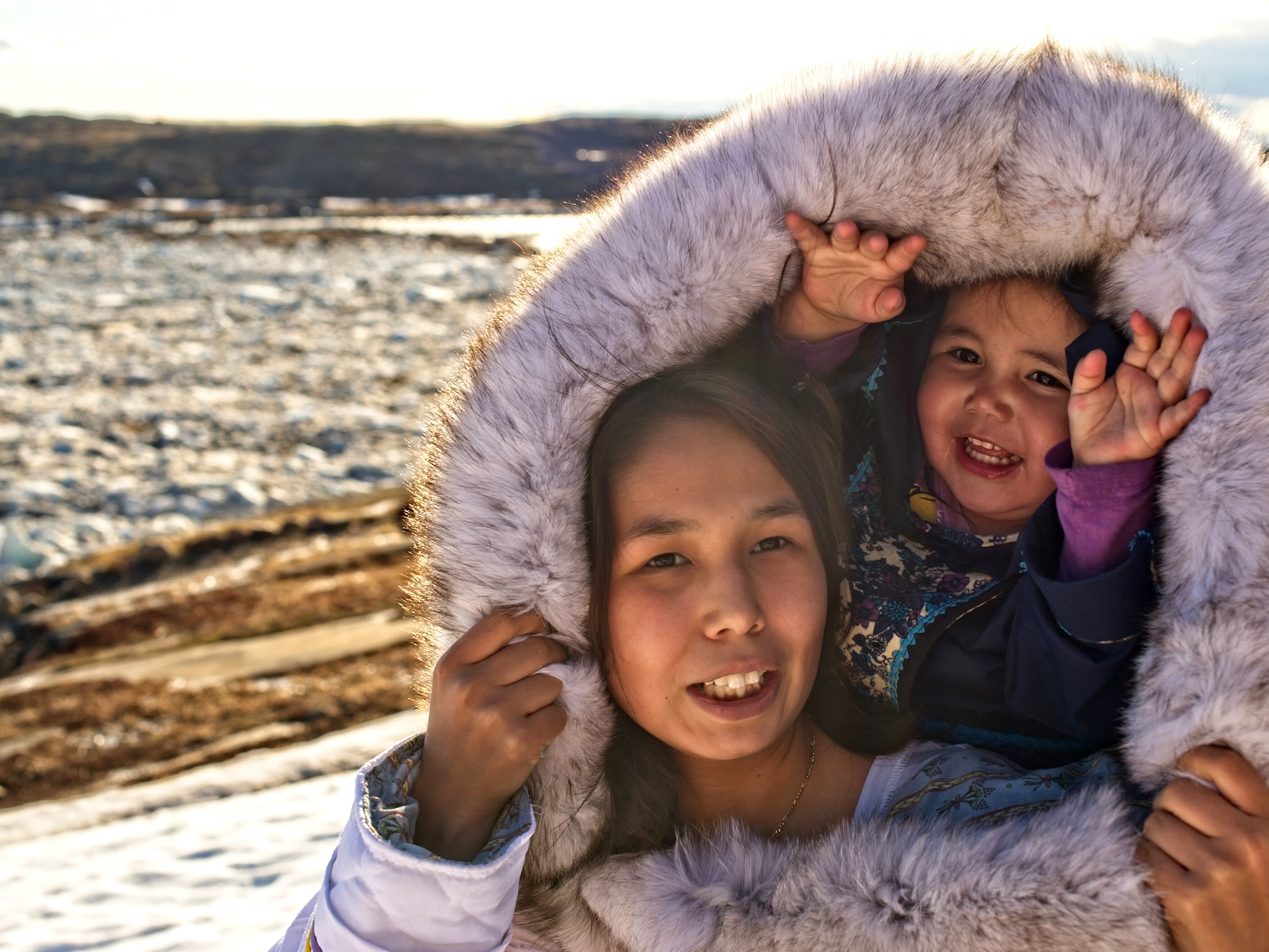
The land above is the home of the Snuneymuxw First Nation of the Coast Salish who live here, on the Gulf Islands, and along the Fraser River. In Hul'q'umin'um' — the lingua franca of the Snuneymuxw First Nation, a living language that expresses their worldview and way of life — the word for octopus is sqi'mukw'. In the Kwak̓wala language of the Kwakiutl or Kwakwaka'wakw, speakers of Kwak'wala, further north on Vancouver Island, octopus or devil fish are known as ta̱k̕wa.

I have gone scuba diving at Madrona Point many times and visited the octopus who squeeze into the eroded sections of a sandstone ledge about 18 metres or 60 feet below the surface. 

On one of those trips, my friend Suzanne Groulx ran into one of the larger males swimming just offshore. I was surfacing as I heard her shriek clear as a bell. Sound moves through water about four times faster than it does through the air — faster than a jet plane. 

On that day, I suspect Suzanne was neck and neck both in sound and motion. Seconds later, she popped up a good three feet above the surf, still screaming. I have never seen anyone surface quite so quickly — dangerous and impressive in equal measure. It was on another of those trips that I met Philip Torrens, with whom I would later co-author, In Search of Ancient BC.     

While the entire coastline is beautiful to explore, it was visiting the octopus that drew me back time and time again. I have seen wee octopus the size of the palm of your hand, large males swimming and feeding and the lovely females tucked into their nursery homes.

After forty days of mating, the female Giant Pacific Octopus attach strings of small fertilized eggs to the rocks within these crevices and call it home for a time — generally five months or 160 days. When I visit, I sometimes bring crab or sea urchin for her to snack on as the mothers guarding these eggs do not leave to hunt, staying ever vigilante protecting their brood from predators. All the while she is here, she gently blows fresh water over the eggs.

And sadly, this will be her only brood. Octopus breed once in their too-short lives. Males die directly after mating and females die once their young have hatched. They live in all the world's oceans and no matter the species, their lifespans are a brief one to five years. I rather hope they evolve to live longer and one day outcompete the humans who like to snack on them.

Octopus are soft-bodied, eight-limbed molluscs of the order Octopoda. They have one hard part, their beaks, which they use to crack open clams, crab and crustaceans. They are ninja-level skilled at squeezing through very tight holes, particularly if it means accessing a tasty snack. The size of their beaks determines exactly how small a hole they can fit through. Looking, you would likely guess it could not be done, but they are amazing — and mesmerizing!

At the Vancouver Aquarium, they have been known to unscrew lids, sneak out of one tank to feed in another then slip back so you do not notice, open simple hooks and latches — burglars of the sea. They can also change the colour and texture of their skin to blend perfectly into their surroundings. You can look for them around reefs and rocky shores. There are 300 species of octopus grouped within the class Cephalopoda, along with squid, cuttlefish, and nautiloids. 

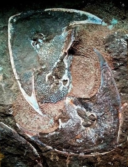
The oldest fossil octopus at 300 million years old is Pohlsepia mazonensis from Carboniferous Mazon Creek fossil beds in Illinois. The only known specimen resembles modern octopuses with the exception of possessing eight arms and two tentacles (Kluessendorf and Doyle 2000).

My favourite fossil octopus is the darling Keuppia levante (Fuchs, Bracchi & Weis, 2009), an extinct genus of octopus that swam our ancient seas back in the Cretaceous.

Monday 21 March 2022

YING YANG: ZYCHASPISES

Zenaspis pololica
A Devonian bony fish mortality plate showing a lower shield of Zenaspis podolica (Lankester, 1869) from Lower Devonian deposits of Podolia, Ukraine.

While war rages on in the Ukraine, our hearts go out to those who live and work here contributing much to our understanding of Podolia, a historic region in Eastern Europe, located in the west-central and south-western parts of Ukraine, in northeastern Moldova. 

As I write this, thousands of Ukrainians are arriving at the Palanca border crossing in Moldova on Ukraine's western border to escape the fighting and pincher advance of the Russian military in the north, south and east. 

Looking at a map of the Ukraine, I imagine a torch touching the edges that mental map alighting it with flame — the edges slowly burning and curling in as the world watches and good people on both sides feel that burn.

We look to the Ukraine with our modern lens as we are want to do. Ukraine emerged as the concept of a nation and the Ukrainians as a nationality with the Ukrainian National Revival in the mid-18th century, in the wake of the peasant revolt of 1768-1769 and the eventual partition of the Polish–Lithuanian Commonwealth. They have known a tense love/hate relationship with their neighboring nations for a long while, sharing culture and language but desiring freedom and independence. 

It became an independent state in 1991 with the collapse of the Soviet Union. This fertile part of the world has an archaeology record of human habitation that goes back to the first millennium BC — the oldest known main inhabitants of Ukraine were Cimmerians. They were replaced in Fifth Century BC by Scythians who ruled till 2nd Century BC. The Sarmatian tribes replaced them. Wars, battles and skirmishes ensued until the tribesmen of the dominant horde, the Alanis, could be said to rule in the First Century AD. While our recorded history, our ancestors likely hunted and past through here far earlier. 

Beneath our human habitation and current military action is bedrock that tells the story of the Earth's violent past. The fauna here are from the Silurian and record a time in our Earth's history where the planet suffered a major mass extinction event that wiped out 23 percent of all marine life. It is the only region in Ukraine where 420 million-year-old remains of ichthyofauna can be found near the surface, making them accessible to collection and study. 

Zenaspis is an extinct genus of jawless fish which thrived during the early Devonian. Being jawless, Zenaspis was probably a bottom feeder, dining on debris from the seafloor similar to how flounder, groupers, bass and other bottom-feeding fish make a living.

For the past 150 years, vertebrate fossils have been found in more than 90 localities situated in outcrops along banks of the Dniester River and its northern tributaries, and in sandstone quarries. 

At present, the faunal list of Early Devonian agnathans and fishes from Podolia number seventy-two species, including 8 Thelodonti, 39 Heterostraci, 19 Osteostraci, 4 Placodermi, 1 Acanthodii, and 1 Holocephali (Voichyshyn 2001a).

In Podolia, the Lower Devonian Redbeds strata (the Old Red Formation or Dniester Series) are 1800 metres thick and range from Lochkovian to Eifelian in age (Narbutas 1984; Drygant 2000, 2003).

In their lower part, the Ustechko and Khmeleva members of the Dniester Series are built from lovely multicoloured, mainly red, fine-grained cross-bedded massive quartz sandstones and siltstones with seams of argillites (Drygant 2000).

We see fossils of Zenaspis in the early Devonian of Western Europe. Both Zenaspis pagei and Zenaspis poweri can be found up to 25 centimetres long in Devonian outcrops of Scotland.

Reference: Voichyshyn, V. 2006. New osteostracans from the Lower Devonian terrigenous deposits of Podolia, Ukraine. Acta Palaeontologica Polonica 51 (1): 131–142. Photo care of the awesome Fossilero Fisherman, a fossil hunter devoted to collecting the Lower Devonian Creek exposures of the Ukraine

Saturday 19 March 2022

INUKTITUT OF THE NUNATSIARMIUT

Nunatsiarmiut Mother and Child, Baffin Island, Nunavut
Warm light bathes this lovely Nunatsiarmiut mother and child from Baffin Island, Nunavut. 

They speak Inuktitut, the mother tongue of the majority of the Nunatsiarmiut who call Baffin Island home. 

Baffin is the largest island in the Arctic Archipelago in the territory of Nunavut in Canada's far north. 

As part of the Qikiqtaaluk Region of Nunavut, Baffin Island is home to a constellation of remote Inuit communities each with a deep cultural connection to the land — Iqaluit, Pond Inlet, Pangnirtung, Clyde River, Arctic Bay, Kimmirut and Nanisivik. 

The ratio of Inuit to non-Inuit here is roughly three to one and perhaps the reason why the Inuktitut language has remained intact and serves as the mother tongue for more than 36,000 residents. Inuktitut has several subdialects — these, along with a myriad of other languages — are spoken across the north.  

If you look at the helpful visual below you begin to get a feel for the diversity of these many tongues. The languages vary by region. There is the Iñupiaq of the Inupiatun/Inupiat; Inuvialuktun of the Inuinnaqtun, Natsilingmiutut, Kivallirmiutut, Aivilingmiutut, Qikiqtaaluk Uannanganii and Siglitun. Kalaallisut is spoken by many Greenlandic peoples though, in northwest Greenland, Inuktun is the language of the Inughuit.

We use the word Inuktitut when referring to a specific dialect and inuktut when referring to all the dialects of Inuktitut and Inuinnaqtun.

Northern Language Map (Click to Enlarge)
Should you travel to the serene glacier-capped wilds and rolling tundra of our far north, you will want to dress for the weather and learn a few of the basics to put your best mukluk shod feet forward. 

The word for hello or welcome in Inuktitut is Atelihai — pronounced ahh-tee-lee-hi. And thank you is nakurmiik, pronounced na-kur-MIIK.  

Perhaps my favourite Inuktitut expression is Naglingniq qaikautigijunnaqtuq maannakautigi, pronounced NAG-ling-niq QAI-kau-ti-gi-jun-naqtuq MAAN-na-KAU-ti-gi. This tongue-twister is well worth the linguistic challenge as it translates to love can travel anywhere in an instant. Indeed it can.

You have likely seen or heard the word Eskimo used in older books to refer to the Inuit, Iñupiat, Kalaallit or Yupik. This misnomer is a colonial term derived from the Montagnais or Innu word ayas̆kimewnetter of snowshoes. It is a bit like meeting a whole new group of people who happen to wear shoes and referring to them all as cobblers — not as a nickname, but as a legal term to describe populations from diverse communities disregarding the way each self-refer. 

Inukshuk / Inuksuk Marker Cairn
For those who identify as Inupiaq or Yupik, the preferred term is Inuit meaning people — though some lingering use of the term Eskimo lives on. The Inuit as a group are made up of many smaller groups. 

The Inuit of Greenland self-refer as Kalaallit or Greenlanders when speaking Kalaallisut. The Inupiat of Alaska, or real people, use Yupik as the singular for real person and yuk to simply mean person.

When taken all together, Inuit is used to mean all the peoples in reference to the Inuit, Iñupiat, Kalaallit and Yupik. Inuit is the plural of inuk or person

You likely recognize this word from inuksuk or inukshuk, pronounced ih-nook-suuk — the human-shaped stone cairns built by the Inuit, Iñupiat, Kalaallit, Yupik, and other peoples of the Arctic regions of northern Canada, Greenland, and Alaska — helpful reference markers for hunters and navigation. The word inuksuk means that which acts in the capacity of a human, combining inuk or person and suk, to substitute

A World of Confusion

You may be disappointed to learn that our northern friends do not live in igloos. I remember answering the phone as a child and the fellow calling was hoping to speak to my parents about some wonderful new invention perfect for use in an igloo. He was disappointed to hear that I was standing in a wooden house with the standard four walls to a room and a handy roof topping it off. "Well, what about your neighbours? Surely some of them live in igloos..." It seems that some of the atlases in circulation at the time, and certainly the one he was looking at, simply blanketed everything north of the 49th parallel in a snowy white. His clearly showed an igloo sitting proudly in the centre of the province.

My cousin Shawn brought one such simplified book back from his elementary school in California. British Columbia had a nice image of a grizzly bear and a wee bit further up, a polar bear grinned smugly. British Columbia's beaver population would be sad to know that they did not inhabit the province though there were two chipper beavers with big bright smiles — one in Ontario and another gracing the province of Quebec. Further north, where folk do build igloos, they were curiously lacking. 

Igloos are used for winter hunting trips much the same way we use tents for camping. The Inuit do not have fifty words for snow — you can thank the ethnographer Franz Boas for that wee fabrication — but within the collective languages of the frozen north there are more than fifty words to describe it. And kisses are not nose-to-nose. To give a tender kiss or kunik to a loved one, you press your nose and upper lip to their forehead or cheek and rub gently. 

Fancy to try a wee bit of Inuktitut yourself? This link will bring you to a great place to start: https://inhabitmedia.com/inuitnipingit/

Inuit Language Map:  By Noahedits - Own work, CC BY-SA 4.0. If you want to the image full size, head to this link: https://commons.wikimedia.org/w/index.php?curid=85587388

Friday 18 March 2022

WASHINGTON'S PILLOW BASALT RHINOCERAS

The Miocene pillow basalts from the Lake Roosevelt National Recreation Area of central Washington hold an unlikely fossil. 

What looks to be a rather unremarkable ballooning at the top of a cave is actually the mould of a small rhinoceros, preserved by sheer chance as its bloated carcass sunk to the bottom of a shallow lake just prior to a volcanic explosion.

We have known about this gem for a long while now. The fossil was discovered by hikers back in 1935 and later cast by the University of California palaeontologists in 1948. 

The Dirty Thirties & The Great Depression

These were the Dirty Thirties and those living in Washington state were experiencing the Great Depression along with the rest of the country and the world. Franklin D. Roosevelt was President of the United States, navigating the States away from laissez-faire economics. 

Charmingly, Roosevelt would have his good name honoured by this same park in April of 1946, a few years before researchers at Berkeley would rekindle interest in the site.

Both hiking and fossil collecting was a fine answer to these hard economic times and came with all the delights of discovery with no cost for natural entertainment. And so it was that two fossil enthusiast couples were out looking for petrified wood just south of Dry Falls on Blue Lake in Washington State. While searching the pillow basalt, the Frieles and Peabodys came across a large hole high up in a cave that had the distinctive shape of an upside-down rhinoceros.

This fossil is interesting in all sorts of ways. First, we so rarely see fossils in igneous rocks. As you might suspect, both magma and lava are very hot. Magma, or molten rock, glows a bright red/orange as it simmers at a toasty 700 °C to 1300 °C (or 1300 °F to 2400 °F) beneath the Earth's surface.

A Rhinoceros Frozen in Lava

During the late Miocene and early Pliocene, repeated basaltic lava floods engulfed about 63,000 square miles of the Pacific Northwest over a period of ten to fifteen million years. After these repeated bathings the residual lava accumulated to more than 6,000 feet.

As magma pushes up to the surface becoming lava, it cools to a nice deep black. In the case of our rhino friend, this is how this unlikely fellow became a fossil. Instead of vaporizing his remains, the lava cooled relatively quickly preserving his outline as a trace fossil and remarkably, a few of his teeth, jaw and bones. The lava was eventually buried then waters from the Spokane Floods eroded enough of the overburden to reveal the remains once more.

Diceratherium tridactylum (Marsh, 1875)
Diceratherium (Marsh, 1875) is known from over a hundred paleontological occurrences from eighty-seven collections.

While there are likely many more, we have found fossil remains of Diceratherium, an extinct genus of rhinoceros, in the Miocene of Canada in Saskatchewan, China, France, Portugal, Switzerland, and multiple sites in the United States.

He has also been found in the Oligocene of Canada in Saskatchewan, and twenty-five localities in the United States — in Arizona, Colorado, Florida, Nebraska, North Dakota, Oregon, South Dakota, Washington and Wyoming.  

Diceratherium was a scansorial insectivore with two horns and a fair bit of girth. He was a chunky fellow, weighing in at about one tonne (or 2,200 lbs). That is about the size of a baby Humpback Whale or a walrus.

Back in the Day: Washington State 15 Million-Years Ago

He roamed a much cooler Washington state some 15 million years ago. Ice dams blocked large waterways in the northern half of the state, creating reservoirs. Floodwaters scoured the eastern side of the state, leaving scablands we still see today. In what would become Idaho, volcanic eruptions pushed through the Snake River, the lava cooling instantly as it burst to the surface in a cloud of steam. 

By then, the Cascades had arrived and we had yet to see the volcanic eruptions that would entomb whole forests up near Vantage in the Takama Canyon of Washington state. 

Know Before You Go

You are welcome to go see his final resting site beside the lake but it is difficult to reach and comes with its own risks. Head to the north end of Blue Lake in Washington. Take a boat and search for openings in the cliff face. You will know you are in the right place if you see a white "R" a couple hundred feet up inside the cliff. Inside the cave, look for a cache left by those who've explored here before you. Once you find the cache, look straight up. That hole above you is the outline of the rhino.

If you don't relish the thought of basalt caving, you can visit a cast of the rhino at the Burke Museum in Seattle, Washington. They have a great museum and are pretty sporting as they have built the cast sturdy enough for folk to climb inside. 

The Burke Museum 

The Burke Museum recently underwent a rather massive facelift and has re-opened its doors to the public. You can now explore their collections in the New Burke, a 113,000 sq. ft. building at 4300 15th Ave NE, Seattle, WA 98105, United States. Or visit them virtually, at https://www.burkemuseum.org/

Photo: Robert Bruce Horsfall - https://archive.org/details/ahistorylandmam00scotgoog, Public Domain, https://commons.wikimedia.org/w/index.php?curid=12805514

Reference: Prothero, Donald R. (2005). The Evolution of North American Rhinoceroses. Cambridge University Press. p. 228. ISBN 9780521832403.

Reference: O. C. Marsh. 1875. Notice of new Tertiary mammals, IV. American Journal of Science 9(51):239-250

Thursday 17 March 2022

AMMOLITE TO BECOME ALBERTA'S PROVINCIAL GEMSTONE

Ammolite from the Bearpaw Formation
Ammolite is an opal-like organic gemstone found primarily along the eastern slopes of the Rocky Mountains of North America. 

With the tabling of a new Bill, this glorious Late Cretaceous shell from long extinct ammonites — marine cephalopods who predated their modern Nautilus cousins — will one day be Alberta's official provincial gemstone. 

The shell has been prized by the Blackfoot Confederacy, the Siksikaitsitapi or Niitsitapi, a collective of many First Nations who have used ammolite for millennia in their hunting rituals. 
It has long been used to attract buffalo, a prized meat for all of the Blackfoot people, the collective of linguistically related groups that includes the Siksika, Kainai or Blood, and two sections of the Peigan or Piikani — the Northern Piikani and Southern Piikani.
 
Now, years later, the mining of ammolite is a serious business and the hunting of these shells is highly guarded. I happened upon a locality while cataloguing fossil oyster and other fauna along the St. Mary's River. It was one of the few times that I have ever been shot at. 

They sunk the wee boat I was using as a raft to haul my finds but I will give them credit for firing warning shots and not actually trying to hit me. With that, I can safely say that ammolite inspires strong emotions amongst fossil collectors — love, greed and glory. 

It is made of the fossilized shells of ammonites, which in turn are composed primarily of aragonite, the same mineral contained in shell nacre, with a microstructure inherited from the shell. It is one of few biogenic gemstones along with amber and pearl.

The chemical composition of ammolite is variable. Aside from aragonite, it may include a mix of calcite, silica, pyrite or wee bits and pieces of other minerals. The shell itself may contain a number of trace elements based on the chemical composition of the original sediments where it was fossilized and chemical goodies carried in from groundwater. Most anything can be found in the mix, but primarily we see aluminium, barium, chromium, copper, iron, magnesium, manganese, strontium, titanium, and vanadium. 

Its crystallography is orthorhombic, a seven-sided crystal system. Its hardness is 3.5–4.5, and its specific gravity is 2.60–2.85. The refractive index of Canadian material (as measured via sodium light, 589.3 nm) is as follows: α 1.522; β 1.672–1.673; γ 1.676–1.679; biaxial negative. Under ultraviolet light, ammolite may fluoresce a mustard yellow.

Ammolite comes from the fossil shells of the Upper Cretaceous disk-shaped ammonites Placenticeras meeki and Placenticeras intercalare, and to a lesser degree, the cylindrical baculite, Baculites compressus. The ammonites that form our Alberta ammolite inhabited a prehistoric, inland subtropical sea that bordered the Rocky Mountains — the Cretaceous Western Interior Seaway. 

As the cephalopods died, they sank to the bottom and were buried by layers of bentonitic mud that eventually became shale. Many gem-quality ammonites are found within siderite concretions. These sediments preserved the aragonite of the shells, preventing them from converting to calcite.

Ammolite: Colourful Microstructure of Aragonite
An iridescent opal-like play of colour is shown in fine specimens in shades of yellow, orange, red, green and gold. 

The iridescence is due to the microstructure of the aragonite: unlike most other gems, whose colours come from light absorption, the iridescent colour of ammolite comes from interference with the light that rebounds from stacked layers of thin platelets that make up the aragonite. 

The thicker the layers, the more reds and greens are produced; the thinner the layers, the more blues and violets predominate. Reds and greens are the most commonly seen colours, owing to the greater fragility of the finer layers responsible for the blues. 

When freshly quarried, these colours are not especially dramatic; the material requires polishing and other treatments to reveal the specimen's full-colour potential.

Ammolite itself is quite thin, generally 0.5–0.8 millimetres (0.02–0.03 inches) thick. This thin coating covers a matrix typically made up of grey to brown shale, chalky clay, or limestone. Truly, when you find these ammonites in the field, they do not look like much. They are perhaps a nice shape but often matte grey and unappealing until prepared.  

Frost shattering of these specimens is common. If left exposed to the elements the thin ammolite tends to crack and flake. Prolonged exposure to sunlight can also lead to bleaching of the generally intense colouration. The cracking results in a tessellated appearance, sometimes described as a "dragon skin" or referred to as a stained glass window pattern. 

Ammolite mined from deeper deposits may be entirely smooth or with a rippled surface. Occasionally a complete ammonite shell is recovered with its structure well-preserved: fine, convoluted lines delineate the shell chambers, and the overall shape is suggestive of a nautilus. While these shells may be as large as 90 centimetres (35.5 inches) in diameter, the iridescent ammonites — as opposed to the pyritized variety — are typically much smaller. Most fossilized shells have had their aragonite pseudomorphously replaced by calcite or pyrite, making the presence of ammolite particularly uncommon.

In 1981, ammolite was given official gemstone status by the World Jewellery Confederation (CIBJO), the same year commercial mining of ammolite began. It was designated the official gemstone of the City of Lethbridge, Alberta in 2007.

Ammolite is also known as aapoak — Kainah for "small, crawling stone" — gem ammonite, calcentine, and Korite. The latter is a Trade name given to the gemstone by the Alberta-based mining company Korite. Roughly half of all ammolite deposits are contained within the Kainah (Kainaiwa) reserve, and its inhabitants play a major role in ammolite mining. Marcel Charbonneau and his business partner Mike Berisoff were the first to create commercial doublets of the gem in 1967. They went on to form Ammolite Minerals Ltd.

Wednesday 16 March 2022

QUENSTEDTOCERAS WITH PATHOLOGY

What you are seeing here is a protuberance extruding from the venter of Quenstedtoceras cf. leachi (Sowerby). It is a pathology in the shell from hosting immature bivalves that shared the seas with these Middle Jurassic, Upper Callovian, Lamberti zone fauna from the Volga River basin. The collecting site is the now inactive Dubki commercial clay quarry and brickyard near Saratov, Russia. 

The site has produced thousands of ammonite specimens. A good 1,100 of those ended up at the Black Hills Institute of Geological Research in Hill City, South Dakota. 

Roughly 1,000 of those are Quenstedtoceras (Lamberticeras) lamberti and the other 100 are a mix of other species found in the same zone. These included Eboraciceras, Peltoceras, Kosmoceras, Grossouvria, Proriceras, Cadoceras and Rursiceras

What is especially interesting is the volume of specimens — 167 Quenstedtoceras (Lamberticeras) lamberti and 89 other species in the Black Hills collection — with healed predation injuries. It seems Quenstedtoceras (Lamberticeras) lamberti are the most common specimens found here and so not surprisingly the most common species found injured. Of the 1,000, 655 of the Quenstedtoceras (Lamberticeras) lamberti displayed some sort of deformation or growth on the shell or had grown in a tilted manner. 

Again, some of the Q. lamberti had small depressions in the centre likely due to a healed bite and hosting infestations of the immature bivalve Placunopsis and some Ostrea

The bivalves thrived on their accommodating hosts and the ammonites carried on, growing their shells right up and over their bivalve guests. This relationship led to some weird and deformities of their shells. They grow in, around, up and over nearly every surface of the shell and seem to have lived out their lives there. It must have gotten a bit unworkable for the ammonites, their shells becoming warped and unevenly weighted. Over time, both the flourishing bivalves and the ammonite shells growing up and over them produced some of the most interesting pathology specimens I have ever seen.    

In the photo here from Emil Black, you can see some of the distorted shapes of Quenstedtoceras sp. Look closely and you see a trochospiral or flattened appearance on one side while they are rounded on the other. 

All of these beauties hail from the Dubki Quarry near Saratov, Russia. The ammonites were collected in marl or clay used in brick making. The clay particles suggest a calm, deep marine environment. One of the lovely features of the preservation here is the amount of pyrite filling and replacement. It looks like these ammonites were buried in an oxygen-deficient environment. 

The ammonites were likely living higher in the water column, well above the oxygen-poor bottom. An isotopic study would be interesting to prove this hypothesis. There's certainly enough of these ammonites that have been recovered to make that possible. It's estimated that over a thousand specimens have been recovered from the site but that number is likely much higher. But these are not complete specimens. We mostly find the phragmocones and partial body chambers. Given the numbers, this may be a site documenting a mass spawning death over several years or generations.

If you fancy a read on all things cephie, consider picking up a copy of Cephalopods Present and Past: New Insights and Fresh Perspectives edited by Neil Landman and Richard Davis. Figure 16.2 is from page 348 of that publication and shows the hosting predation quite well. 

Photos: Courtesy of the deeply awesome Emil Black. These are in his personal collection that I hope to see in person one day. 

It was his sharing of the top photo and the strange anomaly that had me explore more about the fossils from Dubki and the weird and wonderful hosting relationship between ammonites and bivalves. Thank you, my friend!

Tuesday 15 March 2022

GARIBALDI: FIRE AND ICE

Garibaldi Lake having a shy moment tucked behind the cover of wispy clouds. 

The alpine meadows here are glorious to hike. Your efforts are rewarded by views of glaciers and picturesque setting within the protected grounds of Garibaldi Provincial Park.

It is well worth the hike. The lake is 37 km north of Squamish and 19 km south of Whistler. You'll want to bring your cameras and pack out any garbage (as I know you always do) within this wildlife protected area.

The landscape you see here was built by powerful volcanic activity 15,000-20,000 years ago. Lava flows flowed across the land, leaving the remnants of cinder cone volcanoes in their midst. 

These landforms record British Columbia's violent volcanic past and the glacial ice that moved through to smooth much of the mountain tops, hillsides and meadows. The most recent volcanic activity occurred while these lands were just being settled at the end of the last Ice Age — 10,000 years ago.

Mount Garibaldi is one of those eroded volcanoes. It sits two and a half kilometers above the town of Squamish, 80 kilometres north of downtown Vancouver. The glory days of its violent past are now peaceful. 

The lava flows have long cooled and the area now boasts wildflowers and wildlife — an outdoor playground for those looking to get off the beaten path. As you walk these lands, you can see the volcanic debris that formed the western flank of the volcano. It spread across the surface of the glacier then collapsed into the Squamish Valley as the glaciers melted.

Reference:  https://www.cgenarchive.org

Sunday 13 March 2022

A MIGHTY MARINE MOSASAUR FROM VANCOUVER ISLAND

Dove Creek Mosasaur (Tylosaur) found by Rick Ross, VIPS
This specimen of the teeth and lower jawbone of a large marine reptile was discovered by Rick Ross, Vancouver Island Palaeontological Society, during the construction of the Inland Highway, near the Dove Creek intersection, Vancouver Island, British Columbia on Canada's west coast.

If you look closely, you can see several smaller disc-shaped objects to the upper right. These are part of this fellow's sclerotic eye-ring.

These bony plates allowed for safe hunting in deeper waters as the structures protected the delicate eye tissue from the intense water pressure. Diving birds have these same bony plates to aid them in the same way.

Mosasaurs had a hinged jaw that allowed them to swallow prey larger than themselves. They evolved special pterygoid teeth projecting back into the roof of their mouths that acted as guards against escaping prey. The jawbones Rick found were exposed just up to the hinge. Given the size, this toothy fellow could have been as much as seven (7) metres long and weighed up to a tonne.

Along with the significant find of the mosasaur, Rick Ross collected many ammonites and other marine invertebrates exposed during the construction of the Inland Island Highway. He donated the majority of them to the Royal BC Museum in Victoria. They now adorn a cabinet bearing his name and are tucked lovingly in with stories he wrote about his collecting adventures.

Glyptoxoceras heteromorph found by Rick Ross, VIPS
Science owes a great debt to the keen eye and fast thinking of Rick Ross for his work in recovering the specimen. Rick was out on a Sunday looking through the blocks that were destined to be crushed to finish up the tail end of the new highway construction. The crews had just dropped a pile of massive blocks near the Dove Creek Road crossing.

Each of the blocks was one to five tonnes in size. Rick was looking through them when he spotted a concretion sticking out. 

It did not look all that different from the hundreds he had been found up and down the highway. Interested to see what it might contain, Rick took his geology hammer and struck a blow. Off popped the end and inside was a large perfect mosasaur tooth.

Looking closer, he could see a bone sticking out in several other places within this massive block. Excited about the find and not quite sure how to approach excavating it from an active construction site, Rick searched the highway and finally located a maintenance working greasing up some heavy machinery. Rick excitedly told the field mechanic about the find and inquired who would need to be called to save the block. His answer was disappointing. The block was destined to be bulldozed in the morning. 

Panicked but still hopeful, Rick asked who his supervisor was and how to reach him on a Sunday. While initially hesitant, the urgency and excitement in Rick's voice swayed him. With a warning that the supervisor would likely not be impressed to get his call, he relented and shared the telephone number. Rick dialled the number and received the predicted reaction. Unrelenting, Rick swayed the supervisor who agreed that if Rick could get a truck up to the site first thing in the AM, the block could be lifted onto the truck. The next hour was filled with phone calls and putting together a plan to get the mighty block.

Rick called Pat Trask from the Courtenay Museum. The two are fossil hunting buddies and Rick was sure that Pat would be up for the challenge. The next call was to Doug Embree, another fossil hunting buddy from the Comox Valley. As luck would have it, Doug's brother Sam had a two-tonne flatbed truck that they would be able to use. The struggle now was would it take the weight? Monday morning arrived and the block was lifted onto the flatbed with the aid of a drill hole and chain through one corner.

The truck groaned and leaned heavily all the way into town. They had to come in via the 17th Street Bridge as a safe route to the Courtenay Museum. the local building store lent the use of a large forklift to lift the block from the heavily tilted truckbed down onto the back deck of the museum. Once in place, it was far too big to move. It sat there for almost seven years before finally being shipped to a preparatory lab down in Washington. There it was prepped and whittled down to the still massive block we see today.

This specimen is now housed in the Courtenay and District Museum on Vancouver Island, British Columbia. The jaw and associated bones are tagged as a mosasaur, but exactly what kind will need more study. We may be looking at a Tylosaurus, a very large mosasaur with an elongated, cylindrical premaxilla (snout) from which it takes its name. These were the big boys of our ancient seas who snacked on plesiosaurs and other smaller marine reptiles.

T. proriger specimen found with a plesiosaur in its stomach
In 1918, Charles H. Sternberg found a Tylosaurus, with the remains of a plesiosaur in its stomach while collecting in the Smoky Hill Chalk of Logan County, Kansas. You can visit the specimen at the Smithsonian.

Like many other mosasaurs, the early history of this taxon is complex and involves the infamous rivalry between two early American palaeontologists, Edward Drinker Cope and Othniel Charles Marsh. Cope wins the day in terms of longevity in his naming of these mighty beasts.

Though many species of Tylosaurus have been named over the years, only a few are now recognized by scientists as taxonomically valid. They are: Tylosaurus proriger (Cope, 1869), from the Santonian and lower to middle Campanian of North America (Kansas, Alabama, Nebraska) and Tylosaurus nepaeolicus (Cope, 1874), from the Santonian of North America (Kansas). Tylosaurus kansasensis, named by Everhart in 2005 from the late Coniacian of Kansas, has been shown to be based on juvenile specimens of T. nepaeolicus.

It is likely that T. proriger evolved as a paedomorphic variety of T. nepaeolicus, retaining juvenile features into adulthood while attaining a much larger adult size.

Along with plesiosaurs, sharks, fish, and other mosasaurs, Tylosaurus was a dominant predator of the Western Interior Seaway during the Late Cretaceous. The genus was among the largest of the mosasaurs — along with Mosasaurus hoffmannii — with the possibly conspecific Hainosaurus bernardi reaching lengths up to 12.2 meters (40 ft), and T. pembinensis reaching comparable sizes. T. proriger, the largest species of Tylosaurus, reached a whopping 14 m (46 ft). While the Dove Creek Mosasaur was half that size, it may be one of T. proriger's smaller cousins.

Photo One: Dove Creek Mosasaur by Heidi Henderson. Courtenay Museum Collection.
Photo Two: Urakawites heteromorph ammonite by Rick Ross. RBCM Collection
Photo Three: T. proriger specimen which was found with a plesiosaur in its stomach. By Ryan Somma - Flickr, CC BY-SA 2.0, https://commons.wikimedia.org/w/index.php?curid=9004614

Saturday 12 March 2022

PARASAUROLOPHUS WALKERI OF ALBERTA

Holotype Specimen of P. walkeri, Royal Ontario Museum
Closer to home, we can find species of Parasaurolophus walkeri in the Dinosaur Park Formation of Alberta, Canada. 

The Dinosaur Park Formation is the uppermost member of the Belly River Group — also known as the Judith River Group, a major geologic unit in southern Alberta. 

It is an area rich in fossils. The formation contains dense concentrations of dinosaur skeletons, both articulated and disarticulated, often found with preserved remains of soft-tissues. Remains of other animals such as fish, turtles, and crocodilians, as well as plant remains, are also abundant. The formation has been named after Dinosaur Provincial Park, a UNESCO World Heritage Site where the formation is well-exposed in the badlands that flank the Red Deer River.

The Dinosaur Park Formation was deposited during the Campanian stage of the Late Cretaceous, between about 76.9 and 75.8 million years ago in what was an alluvial and coastal plain environment. It is bounded by the nonmarine Oldman Formation below and the marine Bearpaw Formation above.

The formation includes diverse and well-documented fauna including dinosaurs such as the horned Centrosaurus, Chasmosaurus, and Styracosaurus, fellow duckbills Gryposaurus and Corythosaurus, the mighty tyrannosaurid Gorgosaurus, and armoured Edmontonia, Euoplocephalus and Dyoplosaurus

Dinosaur Park Formation is interpreted as a low-relief setting of rivers and floodplains that became more swampy and influenced by marine conditions over time as the Western Interior Seaway transgressed westward. The climate was warmer than present-day Alberta, without frost, but with wetter and drier seasons. Conifers were apparently the dominant canopy plants, with an understory of ferns, tree ferns, and angiosperms.

Some of the less common hadrosaurs in the Dinosaur Park Formation of Dinosaur Provincial Park, such as Parasaurolophus, may represent the remains of individuals who died while migrating through the region. They might also have had a more upland habitat where they may have nested or fed. The presence of Parasaurolophus and Kritosaurus in northern latitude fossil sites may represent faunal exchange between otherwise distinct northern and southern biomes in Late Cretaceous North America. Both taxa are uncommon outside of the southern biome, where, along with Pentaceratops, they are predominant members of the fauna.

Photo: Holotype Specimen: The incomplete Parasaurolophus walkeri type specimen in the Royal Ontario Museum. Location: 43° 40′ 5.09″ N, 79° 23′ 40.59″ W. Shared by MissBossy.

Friday 11 March 2022

TALES OF HAIDA GWAII

A wreck with tales to tell at Naikoon, Haida Gwaii. The islands have gone by many names. To the people who call the islands home, Haida Gwaii means “island of the people,” it is a shortened version of an earlier name, Haadala Gwaii-ai, or “taken out of concealment.” 

Back at the time of Nangkilslas, it was called Didakwaa Gwaii, or “shoreward country.” By any name, the islands are a place of rugged beauty and spirit and enjoy a special place in both the natural and supernatural world. The enormous difference between high and low tide in Haida Gwaii – up to twenty three vertical feet – means that twice a day, vast swathes of shellfish are unveiled, free for the taking. 

An ancient Haida saying is still often heard today, “When the tide is out, the table is set.” Archaeological evidence shows that by about five thousand years ago, gathering shellfish replaced hunting and fishing as their primary food source. The shellfish meat was skewered on sticks, smoked and stored for use in winter or for travel.

Steeped in mist and mythology, the islands of Haida Gwaii abound in local lore that surrounds their beginnings. Today, the Hecate Strait is a tempestuous 40-mile wide channel that separates the mist-shrouded archipelago of Haida Gwaii from the BC mainland. Haida oral tradition tells of a time when the strait was mostly dry, dotted here and there with lakes. During the last ice age, glaciers locked up so much water that the sea level was hundreds of feet lower than it is today. Soil samples from the sea floor contain wood, pollen, and other terrestrial plant materials that tell of a tundra-like environment.

The islands of Haida Gwaii are at the western edge of the continental shelf and form part of Wrangellia, an exotic terrane of former island arcs, which also includes Vancouver Island, parts of western mainland British Columbia and southern Alaska. 

Brewericeras hulenense (Anderson, 1938)
While we’ll see that there are two competing schools of thought on Wrangellia’s more recent history, both sides agree that many of the rocks, and the fossils they contain, were laid down somewhere near the equator. 

They had a long, arduous journey, first being pushed by advancing plates, then being uplifted, intruded, folded, and finally thrust up again. It’s reminiscent of how pastry is balled up, kneaded over and over, finally rolled out, then the process is repeated again.

This violent history applies to most of the rock that makes up the Insular Belt, the outermost edge of the Cordillera. Once in their present location, the rocks that make up the mountains and valleys of this island group were glaciated and eroded to their present form. Despite this tumultuous past, the islands have arguably the best-preserved and most fossil-rich rocks in the Canadian Cordillera, dating from very recent to more than 200 million years old. 

The fossils found in the Triassic rock of Wrangellia are equatorial or low latitude life forms quite different from those found today on the Continent at the latitude of Haida Gwaii. This suggests those rocks were in the equatorial region during the Late Triassic, just over 200 million years ago. 

The Lower Jurassic ammonite faunas found at Haida Gwaii are very similar to those found in the Eastern Pacific around South America and in the Mediterranean. The strata exposed at Maple Island, Haida Gwaii are stratigraphically higher than the majority of Albian localities in Skidegate Inlet. The macrofossil fauna belonged to the Upper part of the Sandstone Member of the Haida formation.

The western end of the island contains numerous well-preserved inoceramids such as Birostrina concentrica and a few rare ammonites of Desmoceras bearskinese. The eastern shores are home to unusual ammonite fauna in the finer grained sandstones. Here we find the fossils as extremely hard concretions while others were loose in the shale. Species include Anagaudryceras sacya and Tetragonites subtimotheanus. A large whorl section of the rare Ammonoceratites crenucostatus has also been found here. The ammonites, Desmoceras; Brewericeras hulenense; Cleoniceras perezianum, Douvelliceras spiniferum are all found in Lower Cretaceous, Middle Albian, Haida Formation deposits.

Thursday 10 March 2022

BC'S FOSSIL BOUNTY — COMING TO TELUS OPTIK TV AUTUMN 2022

We live in a diverse province edged by mountains, ocean, forests and streams. While our lens is often on the rugged beauty all around us, beneath our feet is yet another world.

Layers of rock hold fossils, each an interface to our deep past. 

Within each fragment, these ancient beings whisper their secrets, share their life experiences, tell us tales of community, how they made a living, who they rubbed shoulders with (or fins, or seedlings...) and convey the essence of a world long embedded in stone.

Join me as we explore the rich fossil bounty of fossil plants, dinosaurs to mighty marine reptiles and the people who unearth them.

Discover British Columbia's violent past — how plate tectonics, volcanoes and glaciers shaped the land and why we find plant fossils along the Kitsilano foreshore and marine fossils beneath False Creek. Learn about the science of geochemistry from a palaeontologist who uses fossil teeth to reconstruct ancient environments.

Meet those who call Vancouver home and use this beautiful base for their mining explorations — opening up BC and communities through partnerships that honour First Nations wisdom, show a commitment to social responsibility & sound environmental practices.

​Hear from palaeontologists, geologists, geochemists, science organizations, dinosaur docents, palaeoartists and fossil preparators whose work brings our ancient world to life.

Funding is supported by TELUS STORYHIVE & DINO LAB INC. BC'S FOSSIL BOUNTY — SEASON ONE airs on TELUS Optik TV and the TELUS YouTube Channel to millions of viewers beginning Autumn 2022. Plans for SEASON TWO & SEASON THREE are in the works. 

Visit www.fossilhuntress.com to learn more and to hear updates on the project.

Wednesday 9 March 2022

SQUIRRELS: SHADOW TAILS

One of the little animals I see daily in Kitsilano, Vancouver, are the very busy, highly comic rodents we know as squirrels. 

They spend their days busily gathering and caching food and their nights resting from all that hard work. 

My neighbourhood has mostly Eastern Gray squirrels, Sciurus carolinensis (Gmelin, 1788) who come in a colour palette of reddish-brown, grey (British spelling) and black. 

These cuties have bushy tails and a spring in their step — racing around gathering nuts, finding secret hiding spots to cache them, teasing dogs and generally exuding cuteness.

We find the first fossil evidence of tree squirrels in the Pleistocene. At least twenty specimens have been found of Sciurus carolinensis in Pleistocene outcrops in Florida on the eastern coast of the United States. Over time, their body size grew larger then shrunk down to the 400 to 600 g (14 to 21 oz) weight we see them today.  

Eastern Gray squirrels have two breeding seasons in December-January and June-July. This year has been unseasonably warm. On Vancouver Island, the Eastern Grays bred again in early September. One wonders if the heat dome killed off the July litter, and with the return of more favourable weather, the parents have been induced to breed again.

While they are not native to Vancouver, they are plentiful. They were introduced to the region over a hundred years ago and have been happily multiplying year upon year. 

Our native species are the smaller, reddish-brown, rather shy Douglas squirrels, Tamiasciurus douglasii (Bachman, 1839), and the nocturnal Northern Flying Squirrels, Glaucomys sabrinus (Shaw, 1801).  

Sciurus, is derived from two Greek words, skia, meaning shadow, and oura, meaning tail. The name choice is poetic, alluding to squirrels sitting in the shadow of their tails. 

The specific epithet, carolinensis, refers to the Carolinas on the eastern seaboard of the United States, an area that includes both North and South Carolina. It was here that the species was first recorded and still rather common. In the United Kingdom and Canada, Sciurus carolinensis is referred to as the Eastern Gray or grey squirrel — and though adorable is an invasive species. 

In the United States, Eastern is used to differentiate the species from the Western Gray or Silver-Gray squirrel, Sciurus griseus, (Ord, 1818). 

The Ord here, of course, is George Ord, the American zoologist who named the species based on notes recorded by Lewis and Clark in the early 1800s. If you fancy a read, check out his article from 1815, "Zoology of North America." It is charming, anachronistic and the first systemic zoology of America by an American. 

In the Kwak̓wala language of the Kwakiutl or Kwakwaka'wakw, speakers of Kwak'wala, of the Pacific Northwest, use the word ta̱minasux̱, to express: "that is a squirrel." 

The word for shadow in Kwak'wala is gagumas and tail is ha̱t̕sa̱x̱ste' — so I will think of these wee wonders of the Order Rodentia in the family Sciuridae as the Gagumas ha̱t̕sa̱x̱ste' of Khahtsahlano. 

Tuesday 8 March 2022

FOSSILS AND FIRST NATION HISTORY OF NOOTKA ISLAND

The rugged west coast of Vancouver Island offers spectacular views of a wild British Columbia. Here the seas heave along the shores slowly eroding the magnificent deposits that often contain fossils. 

Just off the shores of Vancouver Island, east of Gold River and south of Tahsis is the picturesque and remote Nootka Island.

This is the land of the proud and thriving Nuu-chah-nulth First Nations who have lived here always

Always is a long time, but we know from oral history and archaeological evidence that the Mowachaht and Muchalaht peoples lived here, along with many others, for many thousands of years — a time span much like always

While we know this area as Nootka Sound and the land we explore for fossils as Nootka Island, these names stem from a wee misunderstanding. 

Just four years after the 1774 visit by Spanish explorer Juan Pérez — and only a year before the Spanish established a military and fur trading post on the site of Yuquot — the Nuu-chah-nulth met the Englishman, James Cook.  

Captain Cook sailed to the village of Yuquot just west of Vancouver Island to a very warm welcome. He and his crew stayed on for a month of storytelling, trading and ship repairs. Friendly, but not familiar with the local language, he misunderstood the name for both the people and land to be Nootka. In actual fact, Nootka means, go around, go around

Two hundred years later, in 1978, the Nuu-chah-nulth chose the collective term Nuu-chah-nulth — nuučaan̓uł, meaning all along the mountains and sea or along the outside (of Vancouver Island) — to describe themselves. 

It is a term now used to describe several First Nations people living along western Vancouver Island, British Columbia. 

It is similar in a way to the use of the United Kingdom to refer to the lands of England, Scotland and Wales — though using United Kingdom-ers would be odd. Bless the Nuu-chah-nulth for their grace in choosing this collective name.  

An older term for this group of peoples was Aht, which means people in their language and is a component in all the names of their subgroups, and of some locations — Yuquot, Mowachaht, Kyuquot, Opitsaht. While collectively, they are the Nuu-chah-nulth, be interested in their more regional name should you meet them. 

But why does it matter? If you have ever mistakenly referred to someone from New Zealand as an Aussie or someone from Scotland as English, you have likely been schooled by an immediate — sometimes forceful, sometimes gracious — correction of your ways. The best answer to why it matters is because it matters.

Each of the subgroups of the Nuu-chah-nulth viewed their lands and seasonal migration within them (though not outside of them) from a viewpoint of inside and outside. Kla'a or outside is the term for their coastal environment and hilstis for their inside or inland environment.

It is to their kla'a that I was most keen to explore. Here, the lovely Late Eocene and Early Miocene exposures offer up fossil crab, mostly the species Raninid, along with fossil gastropods, bivalves, pine cones and spectacularly — a singular seed pod. These wonderfully preserved specimens are found in concretion along the foreshore where time and tide erode them out each year.

Five years after Spanish explorer Juan Pérez's first visit, the Spanish built and maintained a military post at Yuquot where they tore down the local houses to build their own structures and set up what would become a significant fur trade port for the Northwest Coast — with the local Chief Maquinna's blessing and his warriors acting as middlemen to other First Nations. 

Following reports of Cook's exploration British traders began to use the harbour of Nootka (Friendly Cove) as a base for a promising trade with China in sea-otter pelts but became embroiled with the Spanish who claimed (albeit erroneously) sovereignty over the Pacific Ocean. 

VIPS & VanPS Nootka Crew. Photo: John Fam, VanPS
The ensuing Nootka Incident of 1790 nearly led to war between Britain and Spain (over lands neither could actually claim) but talk of war settled and the dispute was settled diplomatically. 

George Vancouver on his subsequent exploration in 1792 circumnavigated the island and charted much of the coastline. His meeting with the Spanish captain Bodega y Quadra at Nootka was friendly but did not accomplish the expected formal ceding of land by the Spanish to the British. 

It resulted however in his vain naming the island "Vancouver and Quadra." The Spanish captain's name was later dropped and given to the island on the east side of Discovery Strait. Again, another vain and unearned title that persists to this day.

Early settlement of the island was carried out mainly under the sponsorship of the Hudson's Bay Company whose lease from the Crown amounted to 7 shillings per year — that's roughly equal to £100.00 or $174 CDN today. Victoria, the capital of British Columbia, was founded in 1843 as Fort Victoria on the southern end of Vancouver Island by the Hudson's Bay Company's Chief Factor, Sir James Douglas. 

With Douglas's help, the Hudson's Bay Company established Fort Rupert on the north end of Vancouver Island in 1849. Both became centres of fur trade and trade between First Nations and solidified the Hudson's Bay Company's trading monopoly in the Pacific Northwest.

The settlement of Fort Victoria on the southern tip of Vancouver Island — handily south of the 49th parallel — greatly aided British negotiators to retain all of the islands when a line was finally set to mark the northern boundary of the United States with the signing of the Oregon Boundary Treaty of 1846. Vancouver Island became a separate British colony in 1858. British Columbia, exclusive of the island, was made a colony in 1858 and in 1866 the two colonies were joined into one — becoming a province of Canada in 1871 with Victoria as the capital.

Dan Bowen, Chair of the Vancouver Island Palaeontological Society (VIPS) did a truly splendid talk on the Fossils of Nootka Sound. With his permission, I have uploaded the talk to the ARCHEA YouTube Channel for all to enjoy. Do take a boo, he is a great presenter. Dan also graciously provided the photos you see here. The last of the photos you see here is from the August 2021 Nootka Fossil Field Trip. Photo: John Fam, Vice-Chair, Vancouver Paleontological Society (VanPS).

What to Know Before You Go — Nootka Trail

The Nootka Trail passes through the traditional lands of the Mowachaht/Muchalat First Nations who have lived here since always. They share this area with Gray whales, humpback whales, orcas, seals, sea lions, black bears, wolves, cougars, eagles, ravens, sea birds, river otters, slugs and the many colourful intertidal creatures that you'll want to photograph.

This is a remote West Coast wilderness experience. Getting to Nootka Island requires some planning as you'll need to take a seaplane or water taxi to reach the trailhead. The trail takes 4-8 days to cover the 37 km year-round hike. The peak season is July to September. Permits are not required for the hike. 

Access via: Air Nootka floatplane, water taxi, or MV Uchuck III

  • Dan Bowen, VIPS on the Fossils of Nootka: https://youtu.be/rsewBFztxSY
  • https://www.thecanadianencyclopedia.ca/en/article/sir-james-douglas
  • file:///C:/Users/tosca/Downloads/186162-Article%20Text-199217-1-10-20151106.pdf
  • Nootka Trip Planning: https://mbguiding.ca/nootka-trail-nootka-island/#overview


Monday 7 March 2022

YANASHALLASH: TRACKING THEROPODS

Left, right, one, two... Theropod Tracks
Left, right, one, two... the wonderfully preserved theropod trackway you see here was found by eagle-eyed construction workers blasting out a tunnel for a road near Yanashallash in the Chavin de Huantar region of Peru. 

You would be surprised how many fossils have been found this way!

The footprints are trace fossils from a big fellow who marched through here back in the Cretaceous. The inflated rust coloured prints were found alongside the fossil crocodile, pterosaurs, primitive tortoise and fish.

Antamina Mining and the Asociacion Ancash have provided funding to turn this remarkable find into an educational exhibit with a research team led by palaeontologist Carlos Vildoso. 

Vildoso along with palaeontologist Patricia Sciammaro (the two are married) founded the Instituto Peruano de Estudios en Paleovertebrados (IPEP) is a non-profit, non-government institution. Their centre focuses on vertebrate palaeontology. Over the years they have built an enviable database of significant Peruvian fossil sites and publish Contribuciones Paleontológicas, a quarterly journal devoted to vertebrate palaeontology. Chévere!

Sunday 6 March 2022

FINDING SMILODON AMONGST THE BONES

This fierce predator with the luxurious coat is Smilodon fatalis — a compact but robust killer that weighed in around 160 to 280 kg and was 1.5 - 2.2 metres long.

Smilodon is a genus of the extinct machairodont subfamily of the felids. It is one of the most famous prehistoric mammals and the best known saber-toothed cat. 

Although commonly known as the saber-toothed tiger, it was not closely related to the tiger or other modern cats.

Up until a few years ago, all the great fossil specimens of this apex predator were found south of us in the United States. That was until some interesting bones from Medicine Hat, Alberta got a second look.

A few years ago, a fossil specimen caught the eye of researcher Ashley Reynolds as she was rummaging through the collections at the Royal Ontario Museum in Toronto. 

Back in the 1960s,  University of Toronto palaeontologist C.S. Churcher and his team had collected and donated more than 1,200 specimens from their many field seasons scouring the bluffs of the South Saskatchewan River near Medicine Hat, Alberta.

Churcher is a delightful storyteller and a palaeontologist with a keen eye. I had the very great pleasure of listening to many of his talks out at the University of British Columbia and a few Vancouver Paleontological Society meetings in the mid-2000s. 


He moved out to the West Coast for his retirement, first to Gabriola Island then to Victoria, but his keen love of the science kept him giving talks to enthralled listeners keen to hear about his survey of the Dakhleh Oasis in the Western Desert of Egypt, geomorphology, stratigraphy, recent biology, Pleistocene and Holocene lithic cultures, insights learned from Neolithic Islamic pottery to Roman settlements.

The specimens he had collected had been roughly sorted but never examined in detail. Reynolds, who was researching the growth patterns and life histories of extinct cats saw a familiar-looking bone from an ancient cat's right front paw. That tiny paw bone had reached through time and was positively identified as Canada's first Smilodon.

These Apex Predators used their exceptionally long upper canine teeth to hunt large mammals. 

Isotopes preserved in the bones of S. fatalis in the La Brea Tar Pits in California tell us that they liked to dine on bison (Bison antiquus) and camels (Camelops) along with deer and tapirs. Smilodon is thought to have killed its prey by holding it still with its forelimbs and biting it. And that was quite the bite!

Their razor-sharp incisors were arranged in an arch. Once they bit down, the teeth would hold their prey still and stabilize it while the canine bite was delivered — and what a bite that was. They could open their mouths a full 120 degrees.

Smilodon died out at the same time that most North and South American megafauna disappeared, about 10,000 years ago. Its reliance on large animals has been proposed as the cause of its extinction, along with climate change and competition with other species. 

Friday 4 March 2022

HORNBY ISLAND: A WEALTH OF NEW FOSSIL FINDS

Pachydiscus suchiaensis ID: 18-08-CP-002
Hornby is a glorious place to collect. It is family and dog friendly. You need to dress for beach collecting preferably with rubber boots, eye protection and clothing for both sun and rain. 

I like to bring a 5-gallon bucket or hard plastic bottomed backpack for my finds. Whatever you bring is going to get wet, muddy and laced with sand. 

As well as a rock hammer, I bring a 2-4 pound sledgehammer and rock pick for collecting and cracking open the concretions here. If you are lucky, when you split them you see a fossil hidden within. 

While that is not always the case, the rewards are well-worth. One such beauty from a glorious day of collecting on Hornby is the beautiful ammonite you see here.

It is nestled amongst the seaweed and modern oysters clinging to the grey shales of the Northumberland Formation is the Upper Cretaceous (Campanian) ammonite Pachydiscus suchiaensis. This is one of my favourite species and is treasured both for its beauty and the fossil site it hails from. 

This darling was found in situ in the 72 million-year-old sediments at Collishaw Point on the northwest side of Hornby Island, southwestern British Columbia.

The island is beautiful in its own right and the fossils from here often keep some of their original shell or nacre which makes them quite fetching. This fellow is found amongst gastropods, shark teeth, fossil crabs, baculites and other bivalve fossils. 

Many of the fossils found at this locality are found in concretions rolled smooth by time and tide. The concretions you find on the beach are generally round or oval in shape and are made up of hard, compacted sedimentary rock. 

These past few years, many new and wonderful specimens have been unearthed — particularly by members of the Vancouver Island Palaeontological Society (VIPS). 

Two particular finds are jaw-droppers — a Diploceras (think one-metre long paperclip, except it is a heteromorph ammonite) longer than your arm and Actinosepia gladius — internal hard body part found in many cephalopods — of a Vampyropod, a member of the proposed group Vampyropoda — equivalent to the superorder Octopodiformes — which includes vampire squid and octopus. 

Not all of these beauties come out in one piece and as well as amazing collecting skill, the VIPS boasts some of the best Fossil Preparators in British Columbia. A nod of respect to both Jason Hawley and Rick Ross in this regard. Rick is a skilled collector and found a rather nice and rare pachydiscid ammonite at Hornby this past year that I had never seen before. It has been a good year for collecting at Collishaw Point. Another notable find was the decapod, Archaeopus vancouverensis (Woodward 1896), found by Adam Melzak this past summer. If you are looking to get out and about, fossil collecting on Hornby Island is the perfect day trip or weekend getaway.

Where to View the Fossils:

The Courtenay Museum, Qualicum Museum and Pacific Museum of the Earth have delightful collections of specimens from the Upper Cretaceous of Hornby Island. This lovely heteromorph ammonite, Nostoceras hornbyense (Whiteaves, 1895) is a classic. The photo below is courtesy of John Fam, Vice-Chair of the Vancouver Paleontological Society (VIPS) on a recent visit to poke through the collections at the Pacific Museum of the Earth. 

It is a classic example of the heteromorph specimens found at Hornby. Bob Copeman found the best Nostoceras hornbyense I have ever seen from these outcrops. Lucky for you, a replica of that specimen has been made is available to be purchased from the VIPS. Always a nice addition to the collection — especially if you keep a teaching collection where specimens need to be handled by younger, rougher hands.

Nostoceras hornbyense (Whiteaves, 1895)
The main topographic feature on Hornby Island is an arcuate mountain of the resistant cliff-forming Geoffrey formation. Near Shingle Spit about half a mile from the coast is Mt. Geoffrey 920-foot peak; from there the mountain gradually drops in elevation to the southeast and to the north.  

It is 700-feet of conglomerate in a homocline striking N 20° W and dipping to the northeast at a shallow angle of about 6°. 

The apex of the arcuate mountain belt points to the southwest. The coast of Hornby is probably a rising shoreline, as indicated by the almost perpendicular cliffs along its periphery. A hundred (100) foot cliffs of Lambert shale extends from Shingle Spit to Phipps Point, while from the latter to Boulder Point, the cliffs are not as steep and are covered in many places by vegetation.

Behind the mountain and almost enclosed by it is the fertile, green Strachan Valley. On the large peninsula which extends in a southeast direction from the north of the island towards St. John’s Point, the Hornby Formation outcrops form the cliffs on the east side of Tribune Bay. The highest of these is about 200 feet. The argillaceous Lambert and Spray formations form the subdued lowlands of the island.

Thursday 3 March 2022

HEROES, VILLIANS AND TYRANTS: HORNBY ISLAND

Villains, tyrants and heroes alike are immortalized in the scientific literature as researchers don each new species a unique scientific name — and rename geographic sites with a settlers' mindset. 

If you pick through the literature, it is a whose who of monied European explorers literally making a name for themselves, sometimes at great cost to their rivals. 

This truth plays out on British Columbia's West Coast and gulf islands and on Hornby Island, in particular. 

The beautiful island of Hornby is in the traditional territory of the Pentlatch or K’ómoks First Nation, who call it Ja-dai-aich, which means the outer island — a reference to Hornby being on the outside of Denman Island off the east coast of Vancouver Island. 

The island is a mix of beach and meadow, forest and stream. While I often walk the lower beachfront, this island boasts a lovely and very walkable mixed forest that covers its higher ground. 

If you explore here, off the beaten path, you will see a mix of large conifers — Western Hemlock, Grand Fir and Lodgepole Pine on the island. Of these, the Western Red Cedar, Thuja plicata, is the most prized by First Nations. It is the Tree of Life that provides bountiful raw materials for creating everything from art to homes to totems and canoes. 

If you explore these forests further, you will also see wonderful examples of the smaller Pacific yew, Taxus brevifolia, a wee evergreen that holds a special place in the hearts of First Nations whose carvers use this wood for bows and paddles for canoes.

Many spectacular specimens of arbutus, Arbutus menziesii, grow along the water's edge. These lovely evergreens have a rich orange-red bark that peels away in thin sheets, leaving a greenish, silvery smooth appearance and a satiny sheen. Arbutus, the broadleaf evergreen species is the tree I most strongly associate with Hornby. Hornby has its fair share of broadleaf deciduous trees. Bigleaf maple, red alder, black cottonwood, Pacific flowering dogwood, cascara and several species of willow thrive here.

There are populations of Garry oak, Quercus garryana, with their deeply lobed leaves, on the southern end of the island and at Helliwell Provincial Park on a rocky headland at the northeast end of Hornby. 
Local First Nations fire-managed these stands of Garry oak, burning away shrubs and other woody plants so that the thick-barked oaks and nutritious starch-rich plants like great camas, Camassia leichtlinii, could thrive without any nutrient competitors. 

Only about 260 acres (1.1 km2) of undisturbed stands of older forests have been identified on Hornby. They amount to roughly 3.5% of the island's surface area. There are roughly 1,330 acres (540 ha) of older second-growth stands on the island, roughly 19% of the island.

Most of the trees you see on the island are Douglas fir, Pseudotsuga menziesii, an evergreen conifer species in the pine family. My Uncle Doug recognized this tree species because of how much the bark looks like bacon — a food he loved. The common name is a nod to the Scottish botanist, David Douglas, who collected and first reported on this large evergreen.

Captain George Vancouver's Commission to Lieutenant
Sadly for Douglas, it is Archibald Menzies, a Scottish physician, botanist, naturalist — and David's arch-rival, whose name is commemorated for science. 

He is also credited with the scientific naming of our lovely arbutus trees. 

Menzies was part of the Vancouver Expedition (1791–1795) a four-and-a-half-year voyage of exploration commanded by Captain George Vancouver of the British Royal Navy.

Their voyage was built on the work of James Cook. Cook was arguably the first ship's captain to ensure his crew remained scurvy free by implementing a practice of nutritious meals — those containing ascorbic acid also known as Vitamin C — and meticulous standards for onboard hygiene. 

Though he did much to lower the mortality rate amongst his crew, he made some terrible decisions that led to his early demise. Cook was attacked and killed in 1779 during his third exploratory voyage in the Pacific while attempting to kidnap the Island of Hawaii's monarch, Kalaniʻōpuʻu. 

During the four and a half year Vancouver Expedition voyage, the crew and officers bickered amongst themselves, circumnavigated the globe, touching down on five continents. Little did they know, for many of them it would be the last voyage they would ever take. 

The expedition returned to a Britain more interested in its ongoing war than in Pacific explorations. Vancouver was attacked by the politically well-connected Menzies for various slights, then challenged to a duel by Thomas Pitt, the 2nd Baron of Camelford. 

The fellow for whom the fair city of Vancouver is named never did complete his massive cartographical work. With health failing and nerves eroded, he lost the dual and his life. It was Peter Puget, whose name adorns Puget Sound, who completed Vancouver's — and arguably Cook's work on the mapping of our world.

And while it is now called Vancouver the city has many names as it falls within the traditional territory of three Coast Salish peoples — the Squamish (Sḵwxwú7mesh), Tsleil-waututh and Xwméthkwyiem ("Musqueam"—from masqui "an edible grass that grows in the sea"), and on the southern shores of Vancouver along the Fraser River, the Xwméthkwyiem.

If you would like to explore more of the history of eponymous naming from Linnaeus to Darwin, to Bowie himself, take a boo at a new book from Stephen B. Heard, "Charles Darwin's Barnacle and David Bowie's Spider. It is fresh off the press and chock full of historical and pop-culture icons.

References: The City of Vancouver Archives has three George Vancouver documents of note:
  • The Commission, dated July 10, 1783, appointing him fourth Lieutenant of the HMS Fame (this is the official document confirming a field commission given to him May 7, 1782)
  • A letter to James Sykes (a Navy Agent in London) written from the ship Discovery (not the same Discovery used by Cook) while in Nootka Sound near the end of Vancouver’s exploration of the West Coast, October 2, 1794. Vancouver states that they have determined that the Northwest Passage does not exist, which was one of the main goals of his voyage
  • A letter to James Sykes written from Vancouver’s home in Petersham, England, after his voyage, October 26, 1797