Tuesday 19 April 2022

EXPLORING THE FOSSIL EXPOSURES OF SOOKE, BRITISH COLUMBIA

Stemec suntokum, Sooke Formation
The diving bird you see here is Stemec suntokum, a Fossil Plopterid from Sooke, British Columbia, Canada.

We all dream of finding new species, and new fossil species in particular. This happens more than you think. As impossible as it sounds, it has happened numerous times at many fossils sites in British Columbia including Sooke on Vancouver Island.

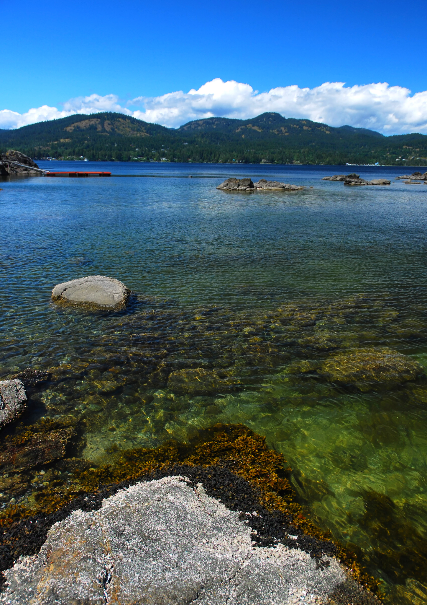
The upper Oligocene Sooke Formation outcrops at Muir Beach on southwestern Vancouver Island, British Columbia where it is flanked by the cool, clear waters of the Strait of Juan de Fuca.

While the site has been known since the 1890s, my first trip here was in the early 1990s as part of a Vancouver Paleontological Society (VanPS) fossil field trip. This easy, beach walk locality is a wonderful place to collect fossils and is especially good for families. If you are solar-powered, you will enjoy the sun playing off the surf from May through September. If you are built of hardier stuff, then the drizzle of Spring or Autumn is a lovely, un-people-y time to walk the beachfront.

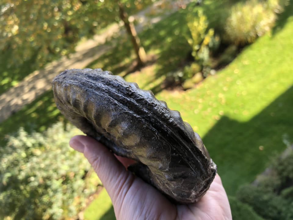
As well as amazing west coast scenery, the beach site outcrop has a lovely soft matrix with well-preserved fossil molluscs, often with the shell material preserved (Clark and Arnold, 1923).

By the Oligocene ocean temperatures had cooled to near modern levels and the taxa preserved here as fossils bear a strong resemblance to those found living beneath the Strait of Juan de Fuca today. Gastropods, bivalves, echinoids, coral, chitin and limpets are common-ish — and on rare occasions, fossil marine mammals, cetacean and bird bones are discovered.

Fossil Bird Bones 

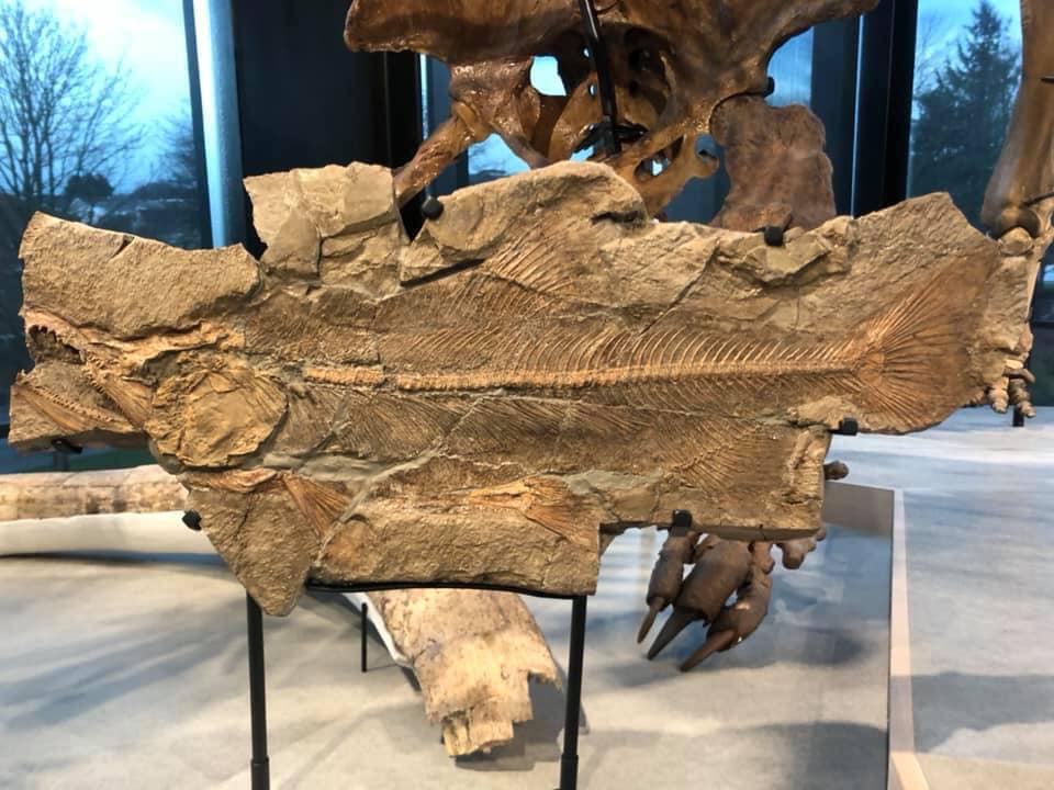
Back in 2013, Steve Suntok and his family found fossilized bones from a 25-million-year-old wing-propelled flightless diving bird while out strolling the shoreline near Sooke. Not knowing what they had found but recognizing it as significant, the bones were brought to the Royal British Columbia Museum to identify.

The bones found their way into the hands of Gary Kaiser. Kaiser worked as a biologist for Environment Canada and the Nature Conservatory of Canada. After retirement, he turned his eye from our extant avian friends to their fossil lineage. The thing about passion is it never retires. Gary is now a research associate with the Royal British Columbia Museum, published author and continues his research on birds and their paleontological past.

Kaiser identified the well-preserved coracoid bones as the first example from Canada of a Plotopteridae, an extinct family that lived in the North Pacific from the late Eocene to the early Miocene. In honour of the First Nations who have lived in the area since time immemorial and Steve Suntok who found the fossil, Kaiser named the new genus and species Stemec suntokum.

Magellanic Penguin Chick, Spheniscus magellanicus
This is a very special find. Avian fossils from the Sooke Formation are rare. We are especially lucky that the bird bone was fossilized at all.  These are delicate bones and tasty. Scavengers often get to them well before they have a chance and the right conditions to fossilize.

Doubly lucky is that the find was of a coracoid, a bone from the shoulder that provides information on how this bird moved and dove through the water similar to a penguin. It's the wee bit that flexes as the bird moves his wing up and down.

Picture a penguin doing a little waddle and flapping their flipper-like wings getting ready to hop near and dive into the water. Now imagine them expertly porpoising —  gracefully jumping out of the sea and zigzagging through the ocean to avoid predators. It is likely that the Sooke find did some if not all of these activities.

When preservation conditions are kind and we are lucky enough to find the forelimbs of our plotopterid friends, their bones tell us that these water birds used wing-propelled propulsion to move through the water similar to penguins (Hasegawa et al., 1979; Olson and Hasegawa, 1979, 1996; Olson, 1980; Kimura et al., 1998; Mayr, 2005; Sakurai et al., 2008; Dyke et al., 2011).

Kaiser published on the find, along with Junya Watanabe, and Marji Johns. Their work: "A new member of the family Plotopteridae (Aves) from the late Oligocene of British Columbia, Canada," can be found in the November 2015 edition of Palaeontologia Electronica. If you fancy a read, I've included the link below.

The paper shares insights into what we have learned from the coracoid bone from the holotype Stemec suntokum specimen. It has an unusually narrow, conical shaft, much more gracile than the broad, flattened coracoids of other avian groups. This observation has led some to question if it is, in fact, a proto-cormorant of some kind. We'll need to find more of their fossilized lineage to make any additional comparisons.

Sooke, British Columbia and Juan de Fuca Strait
Today, fossils from these flightless birds have been found in outcrops in the United States and Japan (Olson and Hasegawa, 1996). They are bigger than the Sooke specimens, often growing up to two metres.

While we'll never know for sure, the wee fellow from the Sooke Formation was likely about 50-65 cm long and weighed in around 1.72-2.2 kg — so roughly the length of a duck and weight of a small Magellanic Penguin, Spheniscus magellanicus, chick. 

To give you a visual, I have included a photo of one of these cuties here showing off his full range of motion and calling common in so many young.

The first fossil described as a Plotopteridae was from a wee piece of the omal end of a coracoid from Oligocene outcrops of the Pyramid Hill Sand Member, Jewett Sand Formation of California (LACM 8927). Hildegarde Howard (1969) an American avian palaeontologist described it as Plotopterum joaquinensis. Hildegarde also did some fine work in the La Brea Tar Pits, particularly her work on the Rancho La Brea eagles.

In 1894, a portion of a pelagornithid tarsometatarsus, a lower leg bone from Cyphornis magnus (Cope, 1894) was found in Carmanah Group on southwestern Vancouver Island (Wetmore, 1928) and is now in the collections of the National Museum of Canada as P-189401/6323. This is the wee bone we find in the lower leg of birds and some dinosaurs. We also see this same bony feature in our Heterodontosauridae, a family of early and adorably tiny ornithischian dinosaurs — a lovely example of parallel evolution.


While rare, more bird bones have been found in the Sooke Formation over the past decade. In 2013, three avian bones were found in a single year. The first two were identified as possibly being from a cormorant and tentatively identified as Phalacrocoracidae tibiotarsi, the large bone between the femur and the tarsometatarsus in the leg of a bird.

They are now in the collections of the Royal BC Museum as (RBCM.EH2013.033.0001.001 and RBCM.EH2013.035.0001.001). These bones do have the look of our extant cormorant friends but the specimens themselves were not very well-preserved so a positive ID is tricky.

The third (and clearly not last) bone, is a well-preserved coracoid bone now in the collection at the RBCM as (RBCM.EH2014.032.0001.001).

The fossil bird find was the first significant find by the Suntok family but not their last. Just last year, they found part of a fish dental plate was studied by Russian researcher Evgeny Popov who named this new genus and species of prehistoric fish Canadodus suntoki, which translates to the "Tooth from Canada." Perhaps not quite as inspired as Kaiser, but a lovely homage to these Citizen Scientists.

Sooke Fossil Fauna

Along with these rare bird bones, the Paleogene sedimentary deposits of the Carmanah Group on southwestern Vancouver Island have a wonderful diversity of delicate fossil molluscs (Clark and Arnold, 1923). Walking along the beach, look for boulders with white shelly material in them. You'll want to collect from the large fossiliferous blocks and avoid the cliffs. The lines of fossils you see in those cliffs tell the story of deposition along a strandline. Collecting from them is both unsafe and poor form as it disturbs nearby neighbours and is discouraged.

Sooke Formation Gastropods, Photo: John Fam
We find nearshore and intertidal genera such as Mytilus (mussels) and barnacles, as well as more typically subtidal predatory globular moon snails (my personal favourite), surf clams (Spisula, Macoma), and thin, flattened Tellin clams.

The preservation here formed masses of shell coquinas that cemented together but are easily worked with a hammer and chisel. Remember your eye protection and I'd choose wellies or rubber boots over runners or hikers.

You may be especially lucky on your day out. Look for the larger fossil bones of marine mammals and whales that lived along the North American Pacific Coast in the Early Oligocene (Chattian).

Concretions and coquinas on the beach have yielded desmostylid, an extinct herbivorous marine mammal, Cornwallius sookensis (Cornwall, 1922) and 40 cm. skull of a cetacean Chonecetus sookensis (Russell, 1968), and a funnel whale, a primitive ancestor of our Baleen whales. 

A partial lower jaw and molar possibly from a large, bear-like beach-dwelling carnivore, Kolponomos, was also found here. A lovely skull from a specimen of Kolponomos clallamensis (Stirton, 1960) was found 60 km southwest across the Strait of Juan de Fuca in the early Miocene Clallam Formation and published by Lawrence Barnes and James Goedert. That specimen now calls the Natural History Museum of Los Angeles County home and is in their collections as #131148.

Directions to Muir Creek Fossil Site at Sooke: 

From the town of Sooke west of Victoria, follow Highway 14 for about 14 kilometres. Just past the spot where the highway crosses Muir Creek, you will see a gravel parking area on your left. Pull in and park here. 

From the barrier, walk out to the beach and turn right (west) and walk until you see the low yellow-brown sandstone cliffs about 400 metres ahead. 

Look at the grey sandstone boulders on the beach with bits of white flecks in them. The fossil material here will most often be a whitish cream colour. Check for low tide before heading out and choose rubber boots for this beach adventure.

References: 

L. S. Russell. 1968. A new cetacean from the Oligocene Sooke Formation of Vancouver Island, British Colombia. Canadian Journal of Earth Science 5:929-933
Barnes, Lawrence & Goedert, James. (1996). Marine vertebrate palaeontology on the Olympic Peninsula. Washington Geology, 24(3):17-25.

Fancy a read? Here's the link to Gary Kaiser's paper: https://palaeo-electronica.org/content/2015/1359-plotopterid-in-canada. If you'd like to head to the beach site, head to: 48.4°N 123.9°W, paleo-coordinates 48.0°N 115.0°W.

Monday 18 April 2022

CANADA'S GREAT BEARS: NA̱N GRIZZLY BEARS

GREAT BEAR NA̱N
Hiking in BC, both grizzly and black bear sightings are common. Nearly half the world's population, some 25,000 Grizzly Bears, roam the Canadian wilderness — of those, 14,000 or more call British Columbia home. 

These highly intelligent omnivores spend their days lumbering along our coastlines, mountains and forests.

Both bear families descend from a common ancestor, Ursavus, a bear-dog the size of a raccoon who lived more than 20 million years ago. Seems an implausible lineage given the size of their very large descendants. 

An average Grizzly weighs in around 800 lbs (363 kg), but a recent find in Alaska tops the charts at 1600 lbs (726 kg). 

This mighty beast stood 12' 6' high at the shoulder, 14' to the top of his head and is one of the largest grizzlies ever recorded — a na̱ndzi.

Adult bears tend to live solo except during mating season. Those looking for love congregate from May to July in the hopes of finding a mate. Through adaptation to shifting seasons, the females' reproductive system delays the implantation of fertilized eggs — blastocysts —until November or December to ensure her healthy pups arrive during hibernation. If food resources were slim that year, the newly formed embryo will not catch or attach itself to her uterine wall and she'll try again next year. 

Females reach mating maturity at 4-5 years of age. They give birth to a single or up to four cubs (though usually just two) in January or February. The newborn cubs are cute little nuggets — tiny, hairless, and helpless — weighing in at 2-3 kilograms or 4-8 pounds. They feast on their mother’s nutrient-dense milk for the first two months of life. The cubs stay with their mamma for 18 months or more. Once fully grown, they can run 56 km an hour, are good at climbing trees and swimming and live 20-25 years in the wild. 

A Grizzly bear encounter inspires a humbling appreciation of just how remarkable these massive beasts are. Knowing their level of intelligence, keen memory and that they have a bite force of over 8,000,000 pascals — enough to crush a bowling ball — inspires awe and caution in equal measure. 

They have an indescribable presence. It is likely because of this that these majestic bears show up often in the superb carvings and work of First Nations artists. I have had close encounters with many bears growing up in the Pacific Northwest, meeting them up close and personal in the South Chilcotins and along our many shorelines. 

First Nation Lore and Language

In the Kwak'wala language of the Kwakiutl First Nations of the Pacific Northwest — or Kwakwaka'wakw, speakers of Kwak'wala — a Grizzly bear is known as na̱n

The ornamental carved Grizzly bear headdress was worn by the comic Dluwalakha Grizzly Bear Dancers, Once more from Heaven, in the Grizzly Bear Dance or Gaga̱lalał, is known as na̱ng̱a̱mł

The Dluwalakha dancers were given supernatural treasures or dloogwi which they passed down from generation to generation. 

In the Hamat'sa Grizzly bear dance, Nanes Bakbakwalanooksiwae, no mask was worn. Instead, the dancers painted their faces red and wore a costume of bearskin or t̓ła̱ntsa̱m and long wooden claws attached to their hands. You can imagine how impressive that sight is lit by the warm flickering flames of firelight during a Winter Dance ceremony.

Smoke of the World / Speaking of the Ancestors — Na̱wiła

Kwaguʼł Winter Dancers — Qagyuhl
Should you encounter a black bear and wish to greet them in Kwak'wala, you would call them t̕ła'yi. Kwakiutl First Nations, Smoke of the World, count Grizzly Bears as an ancestor — along with Seagull, Sun and Thunderbird. 

To tell stories of the ancestors is na̱wiła. Each of these ancestors took off their masks to become human and founded the many groups that are now bound together by language and culture as Kwakwaka’wakw. 

The four First Nations who collectively make up the Kwakiutl are the Kwakiutl (Kwágu7lh), K’umk’utis/Komkiutis, Kwixa/Kweeha (Komoyoi) and Walas Kwakiutl (Lakwilala) First Nations. 

There is likely blood of the Lawit’sis in there, too, as they inhabited the village site at Tsax̱is/T'sakis, Fort Rupert before the Kwakiutl made it a permanent home. 

Not all Kwakwaka'wakw dance the Gaga̱lalał, but their ancestors likely attended feasts where the great bear was celebrated. To speak or tell stories of the ancestors is na̱wiła — and Grizzly bear as an ancestor is na̱n helus.

Visiting British Columbia's Great Bears

If you are interested in viewing British Columbia's Great Bears, do check out Indigenous Tourism BC's wonderfully informative website and the culturally-rich wildlife experiences on offer. You will discover travel ideas and resources to plan your next soul-powered adventure. To learn more about British Columbia's Great Bears and the continuing legacy of First Nation stewardship, visit: 

Indigenous Tourism BC: https://www.indigenousbc.com

Great Bear Lodge has been offering tours to view the majestic animals of the Pacific Northwest. They keep both the guests and the animals' comfort and protection in mind. I highly recommend their hospitality and expertise. To see their offerings, visit: www.greatbeartours.com

Image: Group of Winter Dancers--Qagyuhl; Curtis, Edward S., 1868-1952, https://lccn.loc.gov/2003652753. 

Note: The Qagyuhl in the title of this photograph refers to the First Nation group, not the dancers themselves. I think our dear Edward was trying to spell Kwaguʼł and came as close as he was able. In Kwak'wala, the language of the Kwaguʼł or Kwakwakaʼwakw, speakers of Kwak'wala, the Head Winter Dancer is called t̕seḵa̱me' — and to call someone a really good dancer, you would use ya̱'winux̱w

Charmingly, when Edward S. Curtis was visiting Tsaxis/T'sakis, he was challenged to a wrestling competition with a Giant Pacific Octopus, Enteroctopus dofleini. George Hunt (1854-1933) had issued the challenge and laughed himself senseless when Edward got himself completely wrapped up in tentacles and was unable to move. Edward was soon untangled and went on to take many more photos of the First Nations of the Pacific Northwest. Things did not go as well for the octopus or ta̱ḵ̕wa. It was later served for dinner or dzaḵwax̱stala, as it seemed calamari was destined for that night's menu.  


Sunday 17 April 2022

FOSSIL TURTLES ON THE TRENT: EXPLORING BC

The Trent River near Courtenay, British Columbia is a hotbed of 85-million-year-old fossil fauna immortalized in stone. 

The bedrock of the Trent River has yielded both marine and terrestrial fossils. 

While you might just gloss over that tidbit of information with a casual nod, consider how unlikely this particular fossil site is. We find fossils of species that lived on the land just metres from those who lived in our ancient oceans — remarkable!

We have found a nearly complete terrestrial helochelydrid turtle, the bones of a juvenile elasmosaur marine reptile and the caudal vertebrae of a Hadrosauroid dinosaur who munched on plants, all within spitting distance of one another.

If you stroll along the Trent solo or as part of a guided tour through the Courtenay Museum, you can walk right up to the Hadrosaur site. It was here many years ago that Mike Trask (whose name may ring a bell as he found the first elasmosaur on the Puntledge River) found bones from a duck-bill dinosaur. Now in Alberta, the province just east of British Columbia, there are areas where if you throw a rock, you'll hit a duck-bill bone, but in British Columbia, they were unheard of. This was not just the first duck-billed dinosaur, it was also the first dinosaur found on Vancouver Island — ever.   

Let's park that little bit of goodness for now and hold your awe and applause for the bounty of the Trent and walk just a wee bit down from the hadrosaur site where you come to the greyish bedrock that looks so plain it seems hardly worth noting, but it was once the resting place of a fossil ratfish, one of the ocean's oddest fish.  

If you head a wee bit upriver, you come to the delineation zone marking the contact between the dark grey marine shales and mudstones of the Haslam Formation where they meet the sandstones of the Comox Formation. 

Fossilized material in the Comox sandstones is less abundant but still well worth a look. If you look closely you begin to see fossilized wood and identifiable fossil plant material. So, hadrosaur, terrestrial, ratfish, marine, then terrestrial plant material. This river just keeps on giving.

Further upstream, there is a small tributary, Idle Creek, where you can find more of this terrestrial material in the sandy shales. A little further up the river, you see more identifiable fossil plants beneath your feet and jungle-like, overgrown snarly trees all around you.

Mesopuzosia sp.; Collection of Rick Ross
If you started your journey at the Trent River Falls and walked west, you pass the infamous Ammonite Alley, where you can find Mesopuzosia sp. and Kitchinites sp. of the Upper Cretaceous (Santonian), Haslam Formation. 

I have included one of the yummy, chocolate coloured Mesopuzosia sp. ammonite found, prepped and photographed by the deeply awesome Rick Ross of the Vancouver Island Palaeontological Society for you to enjoy. 

You are now in the Polytychoceras vancouverense zone. Continuing west, we reach the first of two fossil turtle sites on the river — one terrestrial and one marine. I thought I would share a bit about the terrestrial turtle found here as it is one of my favourite discoveries — after the excitement of the elasmosaur excavated last summer.   

Helochelydrids are a group of poorly known turtles from Late Jurassic to Late Cretaceous deposits in North America and Europe. It is the only known North American member of Helochelydridae.

Naomichelys is known from numerous specimens throughout western North America, most notably the holotype partial shell from the Early Cretaceous Cloverly Formation of Montana and a complete skeleton from the Antlers Formation of Texas. The Cloverly Formation includes a number of vertebrate fossils including a diverse assemblage of dinosaur fossils. the site was designated as a National Natural Landmark by the National Park Service in 1973.

Naomichelys is a member of the family Helochelydridae. We find their fossilized remains in Late Jurassic to Late Cretaceous deposits in North America and Europe. Within North America, only the species Naomichelys speciosa is known from relatively complete material which makes comparisons between specimens from other localities challenging. The delightful Phil Currie along with co-authors Matthew J. Vavrek, Derek W. Larson, Donald B. Brinkman and Courtenay's own Joe Morin described the new species of Helochelydrid terrestrial turtle and put the Trent River near Courtenay, British Columbia on the palaeontological map once again.

The new genus and species of helochelydrid turtle were based on the relatively complete shell from the bedrock of the Trent. This area is a section of the marine Haslam Formation (Santonian) of Vancouver Island, British Columbia, Canada.

The new species is characterized by several distinctive shell features, notably a forward curving process on the anterior portion of the hyoplastra, strongly distinguishing it from N. speciosa

The shell is relatively small — and much smaller than one might expect — but does appear to be from a fully grown individual and not a juvenile, suggesting that the species was generally much smaller than other known helochelydrids.

Previously most records of helochelydrids in North America had been assigned to N. speciosa, regardless of actual diagnosable characters. 

The presence of an additional species of helochelydrid from North America tells us that a greater diversity of the taxon was present than was previously recognized. While the interspecific relationships of helochelydrids remain difficult to fully assess, due to the lack of well-preserved specimens, this new species provides additional geographic and phylogenetic data that aids our understanding of this enigmatic group.

As the rock of the Trent River slowly erodes away, it will be interesting to see what it reveals next. We have now found both marine and terrestrial reptiles along with plants, ammonites and other fossil goodies. Tis a story — and river — to keep an eye on!

What to Know Before You Go — Trent River Walk

The full Trent River Walk is 14.8 kilometres of moderate hiking on a well-maintained trail. You may choose to enjoy the wide, flat beginning section of the loop and leave off the narrower sections of the trail where you need to navigate roots and rock. Dogs on leash are welcome. 

You can do this as a family year-round. The trail provides access to the many collecting areas of the river. Be mindful of slippery rocks and keep your eyes peeled for fossils. To enter the trail and find parking, set 375 Hatton Road, Courtenay, British Columbia, into your GPS. Enjoy!   

Saturday 16 April 2022

IN THE FIELD WITH ANDY RANDELL: KITSILANO FOSSIL PLANT SITE

In the Field with Vancouverite Geoscientist Andy Randell — We were super excited to spend a day with the awesome possum that is Andy Randell filming fossils in the field.

We braved the wet and cold on this fine day to head out in search of fossil plants along the Kitsilano foreshore.

And find them we did! 40 million-year-old pretty as you please plant fossils

The Kitsilano fossil plant sites are intriguing as they hold a mystery... why ONLY plants and NO animal fossils? Nary an insect, mammal or reptile to be found. 

We did find some truly lovely plant fossils that speak to a warmer, wetter environment than the Kitsilano we know today. 

Andy shared that the sediments that lay on the foreshore along Kitsilano Beach are thought to be from the Upper Eocene / Early Oligocene in age (38 to 28 million years old), although opinion varies on the exact age with some folk thinking they may be as much as 40 million-years-old. 

The rocks here are layered in stacks of sand, silt and mudstones associated with a lowland estuarine or deltaic environment. If you look closely, you can see signs of the water meandering into channels and ponds of still water. 

The area would have formed a basin, surrounded by mountains that were drained by rivers into this area. It seems that there are no indications of any marine incursions in the sediment pile, and so the area is assumed to have remained stable for some time.

Plant fossils are common in these beds and are often well preserved. The most common are broadleaved deciduous species such as beech, oak, chestnut and hazel, although several coniferous species are known including redwoods (Sequoia), larch, pine and spruce. The deciduous trees like low, moist landscapes which fit with the basin model. The coniferous species likely lived on the surrounding hills where the ground was somewhat drier and their remains transported by rivers into the depositional basin.

There are also regular signs of burning in the fossils – indicating some kind of forest fire events that must have occurred with some frequency.

You will want to catch his wonderfully engaging interviews. Andy is a professional geologist living in Vancouver who is tailoring his career to bring change to the minerals exploration industry. 

Since 2014, he has established his consulting business, SGDS Hive, which takes on graduate geoscientists and mentors them through a variety of exploration projects to help engage and educate the next generation of geologists. 

Andy is the engine behind Below BC, a non-profit society that provides outreach to the public around Earth Science topics, which now serves several thousand people in British Columbia each year. 

His love of geology and palaeontology started early. Andy is a wealth of knowledge on fossil plants. Growing up on the Isle of Wight, he studied plants that are remarkably similar to those we looked at today—and he is a natural behind the lens!

We were joined by my good friend Lauren, the deeply awesome John Fam, Vice-Chair of the Vancouver Paleontological Society & his two boys, Oliver & Liam. 

It was Liam's first fossil field trip & my 7-month old Flat Coat Retriever's first foray into the field. Both Liam and Coco had a grand time! He found fossils that she inspected and on occasion took a wee bite of to see what all the fuss was about.

We were blessed to have David, Andy's partner, teacher & botany buff, along with their two palaeo puppers — Daisy & Dobby — to complete our escort.

With Andy's guidance, everyone found fossil material and learned a lot about how these fossils were originally laid down in a river system.

A huge thank you to Gabriel Mesquita our talented cinematographer! It was a cold, wet day and the entire crew were troopers. If you are planning to visit the Kitsilano foreshore to look for fossils, know that the stairwell access at the base of Dunbar/Alma Street has been washed away. 

You'll want to head to Waterloo Street and make your way to the beach on the rather steep stairwell found there. Surface collecting is fine at this site. Wear rubber boots and know that the rock is very slippery.

Friday 15 April 2022

SHACKLETON'S GREAT ADVENTURE

Stromness Whaling Station
A cautious seal pokes up his head to greet you as you walk the ground of Stromness, an abandoned whaling station on the northern coast of South Georgia Island in the South Atlantic. 

Snuggled at the centre of three harbours on the west side of Stromness Bay, South Georgia, this famous site was the destination of Sir Ernest Shackleton's rescue journey in 1916.

In 1907, a floating factory was built in Stromness Harbour and a land station was added in 1912. 

From 1912 until 1931, Stromness operated as a whaling station — not the proudest moments of our marine overtures. It was later converted into a ship repair yard, machine shop and foundry. From the mid-1930s to 1961, Stromness did minor repairs for a small local customer base then closed down completely, letting nature take back the land and the local animal inhabitants run amock.

The site would gain worldwide recognition with the 1916 landing of Ernest Shackleton and his small crew on the unpopulated southern coast of South Georgia at King Haakon Bay. 

The landing was a Hail Mary moment for the hypothermic men — cold, wet and shivering from an arduous sea voyage in their 22-foot (6.7 m) lifeboat, the James Caird — this was do or die.

Shackleton was on his grandly titled Imperial Trans-Antarctic Expedition, an ambitious and hazardous journey he would embark on in early September 1914, shortly following the outbreak of World War One. This wasn't the ooh-la-la luxurious travel we enjoy today. This was pure rough and tumble — massive ocean swells and bone-shattering storms endured by the hearty. 

Whether or not the aptly named Ernest ever placed his prophetic ad, the words ring true for what the crew endured: "Men Wanted for hazardous journey, small wages, bitter cold, long months of complete darkness, constant danger, safe return doubtful, honor and recognition in case of success." 

Truth in advertising? Generally, we share only the bright blue sky of possibilities, this was the exception to the rule. The adventure was to be a high-risk manoeuvre that could pay off spectacularly — or kill you dead.

He set sail on the Endurance from South Georgia for the Weddell Sea on 5 December, heading for Vahsel Bay. As the ship moved southward navigating through the ice. Deep in the Weddell Sea, conditions gradually grew worse until, on 19 January 1915, Endurance became frozen fast in an ice floe and was abandoned. 

Shackleton refused to pack supplies for more than four weeks, knowing that if they did not reach South Georgia within that time, the boat and its crew would be lost. Shackleton, along with Tom Crean and Frank Worsley, rowed to Elephant Island. Their small craft, the James Caird, was launched on 24 April 1916; during the next fifteen days, it sailed through the waters of the southern ocean, at the mercy of the stormy seas, in constant peril of capsizing. 

On 8 May, thanks to Frank Worsley's navigational skills, the cliffs of South Georgia came into sight. Hope was within sight. Hurricane-force winds prevented the possibility of landing. The party was forced to ride out the storm offshore, in constant danger of being dashed against the rocks.

Finally able to land, the waterlogged men then trekked across South Georgia's mountainous and glaciated interior in an effort to reach help on the populated northern shore of the island.

After 36 hours of crossing the interior, they arrived at the Stromness administration centre, also was the home of the Norwegian whaling station's manager. This building has been dubbed the Villa at Stromness because it represents relative luxury compared to its surroundings. 

Shackleton immediately sent a boat to pick up the three men from the other side of South Georgia while he set to work to organise the rescue of the Elephant Island men. His first three attempts were foiled by sea ice, which blocked the approaches to the island. 

He appealed to the Chilean government, which offered the use of the Yelcho, a small seagoing tug from its navy. Yelcho, commanded by Captain Luis Pardo, and the British whaler Southern Sky reached Elephant Island on 30 August 1916, at which point the men had been isolated there for four and a half months, and Shackleton quickly evacuated all 22 men.

In the decades following its closure, Stromness has been subject to damage from the elements and many of its buildings have been reduced to ruins. 

However, recent efforts have been made to restore the "Villa" and clean up debris from the rest of the site in order to make it safe for visitors. Outside of Stromness is a small whalers' cemetery with 14 grave markers.

Thursday 14 April 2022

SACRED EARTH: HARRISON LAKE

Located three hours east of Vancouver, most folks head to Harrison Lake to enjoy its crisp waters, soak in the hot springs, camp or four-wheel-drive immersed in rugged scenery, or look for the elusive Sasquatch reported to live in the area. 

But there are some who come to Harrison Lake and miss the town entirely. Instead, they favour the upper west side of the lake and the fossiliferous bounty found here.

Indeed, this is the perfect location for local citizen scientists to strut their stuff. Harrison is a perfect family day trip, where you can discover wonderful marine fossil specimens as complete or partially crushed fossilized shells embedded in rock. 

It is truly amazing that we can find them at all. These beauties range in age from Jurassic to Cretaceous, with most being Lower Callovian, meaning the ammonites here swam our ancient oceans more than 160 million years ago. 

The area around Harrison Lake has been home to the Sts’ailes, a sovereign Coast Salish First Nation for thousands of years. Sts’ailes’ means, “the beating heart,” and it sums up this glorious wilderness perfectly. They describe their ancient home as Xa’xa Temexw or Sacred Earth. 

With the settling of Canada, Geologists began exploring the area in the 1880s, calling upon the Sts’ailes to help them look for coal and a route for the Canadian Pacific Railway. Coal was the aim, but happily, they also found fossils. Sacred Earth, indeed.  

Belemnite Fossils
In my favourite outcrops, you can find large, smooth inflated Jurassic ammonites along with their small grey and brown cousins. 

Further up the road, you will see Cretaceous cigar-shaped squid-like cephalopods called Belemnites, and the bivalve (clam) Buchia — gifts deposited by glaciers. Here are the most common.

Ammonites

Almost all of the ammonite specimens found near Harrison Lake are the toonie sized Cadoceras (Paracadoceras) tonniense with well-preserved outer whorls but flattened inner whorls. We find semi-squished elliptical specimens here, too. If you see a large, smooth, inflated grapefruit-sized ammonite, you are holding a rare prize — a Cadoceras comma ammonite, the macroconch or female of the species.  

Ammonites were predatory, squid-like creatures that lived inside coil-shaped shells. Like other cephalopods, ammonites had sharp, beak-like jaws inside a ring of squid-like tentacles that extended from their shells. They used these tentacles to snare prey — plankton, vegetation, fish and crustaceans — similar to the way a squid or octopus hunts today.

Within their shells, ammonites had a number of chambers called septa filled with gas or fluid, and they were interconnected through a wee air tube. By pushing air in or out, they were able to control their buoyancy. 

These small but mighty marine predators lived in the last chamber of their shell and continuously built new shell material as they grew. As they added each new chamber, they would move their squid-like body down to occupy the final outside chamber.

Interestingly, ammonites from Harrison Lake are quite similar to the ones found within the lower part of the Chinitna Formation near Cook Inlet, Alaska, and Jurassic Point, Kyuquot, on the west coast of Vancouver Island — some of the most beautiful places on Earth. 

Buchia (bivalve) Clams

The bivalve or clam Buchia are commonly found at Harrison Lake. You will see them cemented together en masse. . They populated Upper Jurassic–Lower Cretaceous waters like a team sport. When they thrived, they really thrived, building up large coquinas of material. Large boulders of Buchia cemented together en masse hitched a ride with the glaciers and were deposited around Harrison Lake. Some kept going and we find similar erratics or glacier-deposited boulders as far south as Washington state. 

Buchia is used as Index Fossils. Index fossils help us to figure out the age of the rock we are looking at because they are abundant, populate an area en masse, and then die out quickly. In other words, they make it easy to identify a geologic time span.

So what does this mean to you? Now, when you are out and about with friends and discover rocks with Buchia, or made entirely of Buchia, you can say, “Oh, this looks to be Upper Jurassic or Lower Cretaceous. Come take a look! We're likely the first to lay eyes on this little clam since dinosaurs roamed the Earth.” 

Fossil Collecting at Harrison Lake Fossil Field Trip — Getting there

This Harrison Lake site is a great day trip from Vancouver or the Fraser Valley. You will need a vehicle with good tires for travel on gravel roads. Search out the route ahead of time and share your trip plan with someone you trust. If you can pre-load the Google Earth map of the area, you will thank yourself. 

Heading east on from Vancouver, it will take you 1.5-2 hours to reach Harrison Mills. 

Access Forestry Road #17 at the northeast end of the parking lot from the Sasquatch Inn at 46001 Lougheed Hwy, Harrison Mills. From there, it will take about an hour to get to the site. Look for signs for the Chehalis River Fish Hatchery to get you started. 

Drive 30 km up Forestry Road #1, and stop just past Hale Creek at 49.5° N, 121.9° W (paleo-coordinates 42.5° N, 63.4° W) on the west side of Harrison Lake. You will see Long Island to your right. 

The first of the yummy fossil exposures are just north of Hale Creek on the west side of the road. Keep in mind that this is an active logging road, so watch your kids and pets carefully. Everyone should be wearing something bright so they can be easily spotted.

How to Spot the Fossils

The fossils here are easily collected—look in the bedrock and in the loose material that gathers in the ditches. Specimens will show up as either dark grey, grey-brown or black. Look for the large, dark-grey boulders the size of smart cars packed with Buchia. 

And while you are at it, be on the lookout for anything that looks like bone. This site is also ripe for marine reptiles—think plesiosaur, mosasaur and elasmosaur. As a citizen scientist and budding palaeontologist, you might just find something new!

What to Know Before You Go

Fill your gas tank and pack a tasty lunch. As with all trips into British Columbia's wild places, dress for the weather. You will need hiking boots, rain gear, gloves, eye protection, and a good geologic hammer and rock (cold) chisel. 

Wear bright clothing and keep your head covered. Slides are common, and you may start a few if you hike the cliffs. If you are with a group, those collecting below may want to consider hardhats in case of rockfall — chunks of rock the size of your fist up to the size of a grapefruit. They pack a punch. 

Bring a colourful towel or something to put your keepers on. Once you set rock down, it can be hard to find again given the terrain. I take the extra precaution of spraying the ends of my hammers and chisels with yellow fluorescent paint, as I have lost too many in the field. You will also want to bring a camera for the blocks of Buchia that are too big to carry home. 

Identifying Your Treasures

When you have finished for the day, compare your treasures to see which ones you would like to keep. In British Columbia, you are a steward of the fossil, which means they belong to the province, but you can keep them safe. You are not allowed to sell or ship them outside British Columbia without a permit. 

Once you get home, wash and identify your finds. Harrison Lake does not have a large variety of fossil fauna, so this should not be difficult. If your find is coiled and round, it is an ammonite. If it is long and straight, it is a belemnite. And if it looks like a wee fat baby oyster, it is Buchia. This is not always true, but mostly true.

What about collecting fossils in all seasons?. Everyone has a preference. I prefer not to collect in the snow, but I have done it. While sunny days are lovely, it can also be easier to see the specimens when the rock is wet. So, do we do this in the rain? Heck, yeah! 

In torrential rain? 

Yes — once you are hooked, but for your casual friends or the kiddos, the answer is likely no. Choose your battles. They may come with you, but a cold day getting soaked is no fun. 

In time, you will find your inner fossil geek — probably with your first find. And that's just the tip of the iceberg. First, it will be you, then your kids, your friends and then your neighbour. Once you start, it is easy to get hooked. Fossil addiction is real, and the only cure is to get out there and do it some more. You've got this!

References and further information:

A. J. Arthur, P. L. Smith, J. W. H. Monger and H. W. Tipper. 1993. Mesozoic stratigraphy and Jurassic palaeontology west of Harrison Lake, southwestern British Columbia. Geological Survey of Canada Bulletin 441:1-62

R. W. Imlay. 1953. Callovian (Jurassic) ammonites from the United States and Alaska Part 2. The Alaska Peninsula and Cook Inlet regions. United States Geological Survey Professional Paper 249-B:41-108

An overview of the tectonic history of the southern Coast Mountains, British Columbia; Monger, J W H; in, Field trips to Harrison Lake and Vancouver Island, British Columbia; Haggart, J W (ed.); Smith, P L (ed.). Canadian Paleontology Conference, Field Trip Guidebook 16, 2011 p. 1-11 (ESS Cont.# 20110248).


Wednesday 13 April 2022

SQUAMISH: MOTHER OF WIND

View of the Stawamus Chief from the water 
Eagles, bears and breathtakingly beautiful scenery await those who travel north of Vancouver, British Columbia to the town of Squamish.

Nestled at the head of Howe Sound and surrounded by mountains, Squamish is cradled in natural beauty as only a West Coast community can be. 

Growing in fame as the Outdoor Recreation Capital of Canada, visitors enjoy the breathtaking scenery while hiking, climbing, kicking back or participating in the growing number of attractions to explore in this wilderness community.

The area is home to the Squamish First Nation, the Sk̲wx̲wú7mesh Úxumixw and Lil’wat7ul Nations, both descendants of the Coast Salish First Nations. 

Before Europeans came to the Squamish Valley, the area was inhabited by the local First Nations. One of the first contact they had with European outsiders was in 1792, when Captain George Vancouver came to Squamish to trade near the residential area of Brackendale. At the time, the territory of the Sk̲wx̲wú7mesh Úxumixw Nation and Lil’wat7ul Nation extended from present day Greater Vancouver, past Squamish and Brackendale all the way to Gibson's landing, some 6732 square kilometers.

During the 1850s gold miners came in search of gold and an easier gold route to the Interior. Settlers began arriving in the area in 1889, with the majority of them being farmers relocating to the Squamish Valley. The first school was built in 1893 and the first hotel opened in 1902, on the old dock in Squamish.

Squamish means Mother of the Wind in Coast Salish, an homage to the winds that rise from the north before noon and blow steadily until dusk, making Squamish a top wind surfing destination and host to the annual PRO-AM sailboard races. That same wind blows in a fury down the fjord as (outflow) katabatic winds that bring with them trees and other debris that can cripple a watercraft. I have been hit by them on more than one occasion sailing from Vancouver to Bowen Island.  

The impressive cliff you see in the image above is the Stawamus Chief. It began life as a pool of molten magma deep in the Earth's belly. It rose to the surface and began to cool sometime in the early Cretaceous, 100 million years ago, leaving behind the second largest free standing piece of granite in the world at a staggering 2,297 feet — or over 700 metres. 

It has made Squamish one of the top rock climbing destinations in North America and been the source of inspiration for climbing legends like Peter Croft, Hamish Fraser and Greg Foweraker. 

This majestic peak is said to have been one of the last areas of dry ground during a time of tremendous flooding in the Squamish area. Many cultures have a flood myth in their oral history and the Sk̲wx̲wú7mesh Úxumixw are no exception. They tell of a time when all the world save the highest peaks were submerged and only one of their nation survived. Warned in a vision, a fierce and clever warrior escaped to safety atop Mount Chuckigh, now called Mount Garibaldi, as the flood waters rose. 

An Eagle soars near Squamish, BC
Mount Garibaldi Nch’ḵay̓ is an eroded volcano that sits two and a half kilometers above the town of Squamish, 80 kilometres north of downtown Vancouver. It is an impressive site wrapped around Garibaldi Lake with its beautiful blue-green glacier fed waters.

The glory days of its violent past are now peaceful but its history tells the tale of colliding crustal plates, earthquakes and volcanic activity not so long ago.

After the flood, Eagle, a spiritual messenger from the Creator, came to him with a gift of salmon and told him that the world below was again hospitable and ready for his return. He climbed down the mountain to find his village covered by a layer of silt. 

All his people had perished, but his gods gave him another gift, a second survivor of the flood, a beautiful woman who became his wife. 

The couple shared the story of the Eagle's gift. Today, eagle feathers are given as sacred gifts to symbolize courage, wisdom and honour the commitment of relationships as eagles mate for life.  

If you look to the local mountains, you can see another peak that holds the nesting place of another legend. The Sk̲wx̲wú7mesh Úxumixw and Lil’wat7ul Nations share the story of Thunderbird, a supernatural being that causes thunder and lightning, who roosts atop Black Tusk, a volcanic mountain in the local range.

If you are in Squamish in on the first Sunday after New Year's day, you can honour the eagles by participating in the Annual Brackendale Winter Eagle Count.

If you happen down the Sea to Sky Highway anytime between May to October, stop by the BC Museum of Mining or Squamish Adventure Centre. Both offer wonderful educational programs and cultural insights of the area with additional programs being planned..

The Squamish Lil̓wat Cultural Centre and the Whistler Centre for Sustainably support local Indigenous tourism programs with the hope of igniting indigenous-based social enterprises from communities in the Fraser Valley all the way to Lillooet.

Nch’ḵay̓ (Mt. Garibaldi) / Sxeltskwu7 (Ice Cap Peak on the Ashlu/Elaho divide) / Xwsa7k (Mount Baker in Washington State)

Tuesday 12 April 2022

KU'MIS WARRIOR CRAB

Look how epic this little guy is! 

He is a crab — and if you asked him, the fiercest warrior that ever lived. While that may not be strictly true, crabs do have the heart of a warrior and will raise their claws, sometimes only millimetres into the air, to assert dominance over their world. 

Crabs are decapod crustaceans of the Phylum Arthropoda. 

In the Kwak'wala language of the Kwakiutl First Nations of the Pacific Northwest, this brave fellow is ḵ̓u'mis — both a tasty snack and familiar to the supernatural deity Tuxw'id, a female warrior spirit. Given their natural armour and clear bravery, it is a fitting role.

They inhabit all the world's oceans, sandy beaches, many of our freshwater lakes and streams. Some few prefer to live in forests.

Crabs build their shells from highly mineralized chitin — and chitin gets around. It is the main structural component of the exoskeletons of many of our crustacean and insect friends. Shrimp, crab, and lobster all use it to build their exoskeletons.

Chitin is a polysaccharide — a large molecule made of many smaller monosaccharides or simple sugars, like glucose. 

It is handy stuff, forming crystalline nanofibrils or whiskers. Chitin is actually the second most abundant polysaccharide after cellulose. It is interesting as we usually think of these molecules in the context of their sugary context but they build many other very useful things in nature — not the least of these are the hard shells or exoskeletons of our crustacean friends.

Crabs in the Fossil Record

The earliest unambiguous crab fossils date from the Early Jurassic, with the oldest being Eocarcinus from the early Pliensbachian of Britain, which likely represents a stem-group lineage, as it lacks several key morphological features that define modern crabs. 

Most Jurassic crabs are only known from dorsal — or top half of the body — carapaces, making it difficult to determine their relationships. Crabs radiated in the Late Jurassic, corresponding with an increase in reef habitats, though they would decline at the end of the Jurassic as the result of the decline of reef ecosystems. Crabs increased in diversity through the Cretaceous and represented the dominant group of decapods by the end.

We find wonderful fossil crab specimens on Vancouver Island. The first I ever collected was at Shelter Point, then again on Hornby Island, down on the Olympic Peninsula and along Vancouver Island's west coast near Nootka Sound. They are, of course, found globally and are one of the most pleasing fossils to find and aggravating to prep of all the specimens you will ever have in your collection. Bless them.


Monday 11 April 2022

THESCELOSAURUS: THE DAY THE DINOSAURS DIED

Thescelosaurus Leg from Tanis, North Dakota

We live in a remarkable world. For those of us who love palaeontology, we have a huge fondness for animals that lived and died before we ever had a chance to meet them — except through their fossilized bones.

Some of those bones tell the tales of mass extinction events including the one 65 million years ago that took with it our beloved dinosaurs, ammonites and all sorts of wonderful creatures.

Not every animal that has ever lived has left traces of their existence for us to find. We find many, yes, but like the flora and fauna of our extant Earthly creatures, we are finding new ones all the time.

One such beastie is a pterosaur, the first of its kind from North America. A recent find of a perfectly preserved Thescelosaurus leg shows the first evidence of its scaly skin.

These are the latest stunning fossils to emerge from Tanis, a remarkable site in North Dakota, which some scientists think captured the first hours following the crash of the asteroid that killed off the dinosaurs. The fossil finds are remarkable and controversial for many reasons.

Tanis fossils have been boggling — and sometimes aggravating — scientists since 2019, when they were first reported in The New Yorker rather than in a peer-reviewed paper. The latest discoveries are featured in a BBC documentary hosted by iconic naturalist David Attenborough.

https://www.bbc.com/news/science-environment-61013740

Sunday 10 April 2022

Saturday 9 April 2022

OH, CORONICERAS!

Coroniceras sp. from Sayward, British Columbia
This yummy Jurassic ammonite with the creamy dark chocolate colouring is from an all but inaccessible site in Sayward, Bonanza Group, Vancouver Island, British Columbia, Canada. 

I passed through Sayward this past week on the way to northern Vancouver Island. It is much as I remember it — rugged, remote and beautiful. Think trees and valleys for as far as the eye can see. 

This area is home to the We Wai Kai and Wei Wai Kum First Nations and lands of the K'omoks whose culture thrives and reflects the natural rugged beauty of the central island region.

He's a Coroniceras sp. with a truly marvellous keel.

By the time these ammonites were being buried in sediment, Wrangellia, the predominately volcanic terrane that now forms Vancouver Island and Haida Gwaii, had made its way to the northern mid-latitudes.

Within the basal part of the sequence, sedimentary beds are found interbedded with lapilli and crystal tuffs. Here you'll see maroon tuffaceous sandstone, orange-grey sandstone, granule sandstone and conglomerate. Within them we find ammonites nestled in with gastropods and pelecypods. 

While the fossiliferous outcrop is quite small, the Bonanza group is much larger, estimated to be at least 1000 metres thick. The site is quite small and in an active logging area, so the window to collect was limited. The drive up the mountain was thrilling as there had just been heavy rains and the road was washed out and narrowed until it was barely the width of our wheelbase and very, very steep. Closer to the top it narrowed to be just shy of the width of the vehicle — thrilling, to say the least. 

So scary that my passengers all got out as there was a high probability of going head-first over the edge. I was navigating by some handwritten field notes and a wee map on a paper napkin that should have read, "park at the bottom and hike up." 

Did we park at the bottom and hike up? No, we did not. 

The torrential rains of the Pacific Northwest had been working their magic on the hillside and slowly washing out the road until it slowly became more of a trail.

At the base of the hillside all looked well. Giddy for the fossils to come, we ventured off with a truck full of enthusiasm. Within 15 minutes of steep elevation gain, we had a wonderful view of the valley below. We were halfway up the mountain before I realized the error of my ways. The road twisted and turned then slowly narrowed to the width of my tires. Too narrow to turn around, so the only way was up. 

Graham Beard from Qualicum Beach was the fellow who showed me the site and drew the wee map for me. I cannot recall everyone on the trip, but Perry Poon was there — he shot a video of the drive up that he described as thrilling. I have never seen it but would like to one day — and so was Patricia Coutts with her lovely Doberman. 

She and I had just done a trip up to Goldbridge where the cliff we were on had turned into a landslide into a ravine so she was feeling understandably cautious about the power of Mother Nature. Picture the angle, the hood of my jeep riding high and hiding what remained of the road beneath and a lovely stick shift that made you roll backwards a wee bit with every move to put it into gear. So, without being able to see the very narrow path beneath, I had to just keep going. 

Both Perry and Patricia helped with filling in the potholes so my tires would have something to grip. I bent the frame on the jeep heading up and had some explaining to do when I returned it to the car rental place. 

In the end, we found what we were looking for. Memekay yields a mix of ammonites, gastropods and bivalves. 

Many of them are poorly preserved. It was a hell of a ride but well worth the effort as we found some great fossils and with them more information on the palaeontology and geology of Vancouver Island. Just look at the keel on this beauty.

I would share the site information but it is now covered over with debris and inaccessible. One day, this whole region will be developed and the site will be opened up again. Until then, we'll have to enjoy what has been unearthed.

Friday 8 April 2022

SABRE-TOOTHED SALMON: FOSSILS OF WASHINGTON STATE

This toothy specimen is an Oncorhynchus nerka, a Pleistocene Sockeye Salmon from outcrops along the South Fork Skokomish River, Olympic Peninsula, Washington State, USA.

The area is home to the Skokomish — one of nine tribes of the Twana, Coast Salish First Nations in the northern-mid Puget Sound area of western Washington state in the United States. 

Each of the Tribal Nations are known by their locations — Dabop, Quilcene or salt-water people, Dosewallips, Duckabush, Hoodsport, Skokomish or Skoko'bsh, Vance Creek, Tahuya, and Duhlelap or Tule'lalap. The name Skokomish means river people or people of the river in the language of the Twana, sqʷuqʷóbəš or sqWuqWu'b3sH.

Closer to my home farther north in the Pacific Northwest on northern Vancouver Island are the Kwakiutl or Kwakwaka'wakw, speakers of Kwak'wala. Here, sockeye salmon are known as ma̱łik. You would likely recognize these fossils' modern counterparts from their distinctive red bodies and greenish heads. 

Their descendants had been absent from the Skokomish River for more than a decade up to 2014 when construction to augment the negative impact of the Cushman Reservoir was undertaken to restore their natural habitat.

The fossil specimens include individuals with enlarged breeding teeth and worn caudal fins. It is likely that these salmon acted very similar to their modern counterparts with males partaking in competitive and sneaky tactics to gain access to the sexiest (large and red) females who were ready to mate. These ancient salmon had migrated, dug their nests, spawned and defended their eggs prior to their death. For now, we're referring to the species found here as Oncorhynchus nerka, as they have many of the characteristics of sockeye salmon, but also several minor traits of the Pink Salmon, Oncorhynchus gorbuscha.

I had expected to learn that the locality contained a single or just a few partial specimens, but the fossils beds are abundant with large, 45–70 cm, four-year-old adult salmon concentrated in a beautiful sequence of death assemblages.

Oncorhynchus nerka, Pleistocene Sockeye Salmon
Gerald Smith, a retired University of Michigan professor was shown the specimens and recognized them as Pleistocene, a time when the northern part of North America was undergoing a series of glacial advances and retreats that carved their distinctive signature into the Pacific Northwest.

It looks as though this population diverged from the original species about one million years ago, possibly when the salmon were deposited at the head of a proglacial lake impounded by the Salmon Springs advancement of a great glacier known as the Puget lobe of the Cordilleran Ice Sheet. 

Around 17,000 years ago, this 3,000 foot-thick hunk of glacial ice had made its way down from Canada, sculpting a path south and pushing its way between the Cascade and Olympic Mountains. The ice touched down as far south as Olympia, stilled for a few hundred years, then began to melt.

After the ice began melting and retreating north, the landscape slowly changed —  both the land and sea levels rising — and great freshwater lakes forming in the lowlands filled with glacial waters from the melting ice. The sea levels rose quite considerably, about one and a half centimetres per year between 18,000 and 13,000 years ago. The isostatic rebound (rising) of the land rose even higher with an elevation gain of about ten centimetres per year from 16,000 to 12,500 years ago.

Around 14,900 years ago, sea levels had risen to a point where the salty waters of Puget Sound began to slowly fill the lowlands. Both the land and sea continued to rise and by 5,000 years ago, the sea level was about just over 3 meters lower than it is today. The years following were an interesting time in the geologic history of the Pacific Northwest. The geology of the South Fork Skokomish River continued to shift, undergoing a complicated series of glacial damming and river diversions after these salmon remains were deposited.

Today, we find their remains near the head of a former glacial lake at an elevation of 115 metres on land owned by the Green Diamond Company. The first fossil specimens were found back in 2001 by locals fishing for trout along the South Fork Skokomish River.

Upon seeing the fossil specimens, Smith teamed up with David Montgomery of the University of Washington, Seattle, along with N. Phil Peterson and Bruce Crowley, a Late Oligocene Mysticete specialist from the Burke Museum, to complete fieldwork and author a paper.

The fossil specimen you see here is housed in the Burke Museum collection. They opened the doors to their new building and exhibitions in the Fall of 2019. These photos are by the deeply awesome John Fam from a trip to see the newly opened exhibits this year. If you fancy a visit to the Burke Museum, check out their website here: https://www.burkemuseum.org/.

David B. Williams did up a nice piece on historylink.org on the Salmon of the Puget lowland. You can find his work here: https://www.historylink.org/File/20263

If you'd like to read more of the papers on the topic, check out:

  • Smith, G., Montgomery, D., Peterson, N., and Crowley, B. (2007). Spawning sockeye salmon fossils in Pleistocene lake beds of Skokomish Valley, Washington. Quaternary Research, 68(2), 227-238. doi:10.1016/j.yqres.2007.03.007.
  • Easterbrook, D.J., Briggs, N.D., Westgate, J.A., and Gorton, M.P. (1981). Age of the Salmon Springs Glaciation in Washington. Geology 9, 87–93.
  • Hikita, T. (1962). Ecological and morphological studies of the genus Oncorhynchus (Salmonidae) with particular consideration on phylogeny. Scientific Reports of the Hokkaido Salmon Hatchery 17, 1–97.

If you fancy a read of Crowley's work on Late Oligocene Mysticete from Washington State, you can check out:  Crowley, B., & Barnes, L. (1996). A New Late Oligocene Mysticete from Washington State. The Paleontological Society Special Publications, 8, 90-90. doi:10.1017/S2475262200000927

Wednesday 6 April 2022

INSPIRED BY NATURE / AMMONITE BOUNTY

Argonauticeras besairei, José Juárez Ruiz
An exceptional example of the fractal building of an ammonite septum, in this clytoceratid Argonauticeras besairei from the awesome José Juárez Ruiz.

Ammonites were predatory, squidlike creatures that lived inside coil-shaped shells.

Like other cephalopods, ammonites had sharp, beak-like jaws inside a ring of squid-like tentacles that extended from their shells. 

They used these tentacles to snare prey, — plankton, vegetation, fish and crustaceans — similar to the way a squid or octopus hunt today.

Catching a fish with your hands is no easy feat, as I am sure you know. But the Ammonites were skilled and successful hunters. They caught their prey while swimming and floating in the water column. 

Within their shells, they had a number of chambers, called septa, filled with gas or fluid that were interconnected by a wee air tube. By pushing air in or out, they were able to control their buoyancy in the water column. They lived in the last chamber of their shells, continuously building new shell material as they grew. As each new chamber was added, the squid-like body of the ammonite would move down to occupy the final outside chamber.

They were a group of extinct marine mollusc animals in the subclass Ammonoidea of the class Cephalopoda. 

These molluscs commonly referred to as ammonites are more closely related to living coleoids — octopus, squid, and cuttlefish — than they are to shelled nautiloids such as the living nautilus species.

Ammonoidea can be divided into six orders:

  • Agoniatitida: Lower Devonian - Middle Devonian
  • Clymeniida: Upper Devonian
  • Goniatitida: Middle Devonian - Upper Permian
  • Prolecanitida: Upper Devonian - Upper Triassic
  • Ceratitida: Upper Permian - Upper Triassic
  • Ammonitida: Lower Jurassic - Upper Cretaceous

Ammonites have intricate and complex patterns on their shells called sutures. The suture patterns differ across species and tell us what time period the ammonite is from. 

If they are geometric with numerous undivided lobes and saddles and eight lobes around the conch, we refer to their pattern as goniatitic, a characteristic of Paleozoic ammonites.

If they are ceratitic with lobes that have subdivided tips; giving them a saw-toothed appearance and rounded undivided saddles, they are likely Triassic. For some lovely Triassic ammonites, take a look at the specimens that come out of Hallstatt, Austria and from the outcrops in the Humboldt Mountains of Nevada.

Hoplites bennettiana (Sowby, 1826) Christophe Marot
If they have lobes and saddles that are fluted, with rounded subdivisions instead of saw-toothed, they are likely Jurassic or Cretaceous. If you'd like to see a particularly beautiful Lower Jurassic ammonite, take a peek at Apodoceras. Wonderful ridging in that species.

One of my favourite Cretaceous ammonites is the ammonite, Hoplites bennettiana (Sowby, 1826). 

This beauty is from Albian deposits near Carrière de Courcelles, Villemoyenne, near la région de Troyes (Aube) Champagne in northeastern France.

At the time that this fellow was swimming in our oceans, ankylosaurs were strolling about Mongolia and stomping through the foliage in Utah, Kansas and Texas. Bony fish were swimming over what would become the strata making up Canada, the Czech Republic and Australia. Cartilaginous fish were prowling the western interior seaway of North America and a strange extinct herbivorous mammal, Eobaatar, was snuffling through Mongolia, Spain and England.

In some classifications, these are left as suborders, included in only three orders: Goniatitida, Ceratitida, and Ammonitida. Once you get to know them, ammonites in their various shapes and suturing patterns make it much easier to date an ammonite and the rock formation where it is found.

Ammonites first appeared about 240 million years ago, though they descended from straight-shelled cephalopods called bacrites that date back to the Devonian, about 415 million years ago, and the last species vanished in the Cretaceous–Paleogene extinction event.

They were prolific breeders that evolved rapidly. If you could cast a fishing line into our ancient seas, it is likely that you would hook an ammonite, not a fish. They were prolific back in the day, living (and sometimes dying) in schools in oceans around the globe. We find ammonite fossils — and plenty of them — in sedimentary rock from all over the world.

In some cases, we find rock beds where we can see evidence of a new species that evolved, lived and died out in such a short time span that we can walk through time, following the course of evolution using ammonites as a window into the past.

For this reason, they make excellent index fossils. An index fossil is a species that allows us to link a particular rock formation, layered in time with a particular species or genus found there. 

Generally, deeper is older, so we use the sedimentary layers of rock to match up to specific geologic time periods, rather like the way we use tree rings to date trees. A handy way to compare fossils and date strata across the globe.

References: Inoue, S., Kondo, S. Suture pattern formation in ammonites and the unknown rear mantle structure. Sci Rep 6, 33689 (2016). https://doi.org/10.1038/srep33689

https://www.nature.com/articles/srep33689?fbclid=IwAR1BhBrDqhv8LDjqF60EXdfLR7wPE4zDivwGORTUEgCd2GghD5W7KOfg6Co#citeas

Photos: Argonauticeras besairei from the awesome José Juárez Ruiz.

Photo: Hoplites bennettiana from near Troyes, France. Collection de Christophe Marot

Tuesday 5 April 2022

ANKYLOSAURS: THE LAST OF THE NON-AVIAN DINOSAURS

Ankylosaur — Armoured Plant-Eating Dinosaur
Ankylosaurs were armoured dinosaurs. We find their fossil remains in Cretaceous outcrops in western North America. They were amongst the last of the non-avian dinosaurs.

These sturdy fellows ambled along like little tanks all covered in spiky armour. They munched on foliage and were the original lawn mowers — 68 - 66 million years ago.

They reached about 1.7 m in height and weighed in at 4,800 – 8,000 kg. You can see the club at the end of their tail that they used to defend against predators. It would have packed quite the wallop.
The lovely illustration you see here is by the supremely talented Daniel Eskridge, shared with permission. You can see more of his work at www.fineartbydaniel.com