Sunday 16 October 2022

VANCOUVER ISLAND'S HASLAM FORMATION

Steller's Jay, Cyanocitta stelleri
One of the classic Vancouver Island fossil localities is the Santonian-Maastrichtian, Upper Cretaceous Haslam Formation Motocross Pit near Brannen Lake, Nanaimo, British Columbia, Canada.

The quarry is no longer active as such though there is a busy little gravel quarry a little way down the road closer to Ammonite falls near Benson Creek Falls.

Today it is an active motocross site and remains one of the classic localities of the Nanaimo Group. We find well-preserved nautiloids and ammonites — Canadoceras, Pseudoschloenbachia, Epigoniceras — the bivalves — Inoceramus, Sphenoceramus— gastropods, and classic Nanaimo Group decapods — Hoploparia, Linuparus. We also find fossil fruit and seeds which tell the story of the terrestrial history of Vancouver Island.

Upper Cretaceous Haslam Formation Motocross Pit near Brannen Lake
It was John Fam, Vice-Chair, Vancouver Island Paleontological Society (VanPS), who originally told me about the locality. John is one of the most delightful and knowledgeable people you'd be well-blessed to meet.

While he lived on Vancouver Island, he was an active member of the VanPS back when I was Chair. Several of the best joint VIPS/VanPS paleontological expeditions were planned with or instigated by his passion for fossils. I tip my hat to him for his passion and shared love of all things paleo.

John grew up 15 minutes from the motocross locality and used to collect there a few times a week with his father. John has wonderful parents and since marrying his childhood sweetheart, the amazing Grace, those excellent genetics, curiosity and love of fossils are now being passed to a new generation. It's lovely to see John and Grace continuing tradition with two boys of their own.

I met John way back then and did an overnight at his parent's house the Friday before a weekend field trip to Jurassic Point. It was a joy to have him walk me through his collections and tell his stories from earlier years. After learning about the site from John, I headed up to the Motocross Pit with my Uncle Doug. He was a delightful man who grew up on the coast and had explored much of it but not the fossil site just 10-minutes from his home. It was wonderful to walk through time with him so many years ago and then again solo this past year with sadness in my belly that one of the best I've ever known has left this Earth.

Upper Cretaceous Haslam Formation Motocross Pit near Brannen Lake
There were some no trespassing signs up but no people around, so I walked the periphery looking for the bedrock of the Haslam.

The rocks we find here were laid down south of the equator as small, tropical islands. They rode across the Pacific heading north and slightly east over the past 80 million years to where we find them today.

Jim Haggart and Peter Ward have done much to increase our understanding of the molluscan fauna of the Nanaimo Group. Personally, both personify the charming Indiana Jones school of rugged manly palaeontologists you picture in popular film. Professionally, their singular contributions and collaborative efforts have helped shape our understanding of the correlation of Nanaimo Group fauna to those we find in the Gulf Islands of British Columbia and down in the San Juan Islands of Washington State.

Their work builds on the work of Usher (1952), Matsumoto (1959a, 1959b) and Mallory (1977). A healthy nod goes out to the work of Muller and Jeletzky (1970) for untangling the lithostratigraphic and biostratigraphic foundation for our knowledge of the Nanaimo Group.

Candoceras yokoyama, Photo: John Fam, VanPS
As I walked along the bedrock of the Haslam, a Steller's Jay, Cyanocitta stelleri, followed me from tree to tree making his guttural shook, shook, shook call. Instructive, he seemed to be encouraging me, timing his hoots to the beat of my hammer. Vancouver Island truly has glorious flora and fauna.

Fancy some additional reading? Check out a paper published in the Journal of Paleontology back in 1989 by Haggard and Ward on new Nanaimo Group Ammonites from British Columbia and Washington State.

In it, they look at the ammonite species Puzosia (Mesopuzosia) densicostata Matsumoto, Kitchinites (Neopuzosia) japonicus Spath, Anapachydiscus cf. A. nelchinensis Jones, Menuites cf. M. menu (Forbes), Submortoniceras chicoense (Trask), and Baculites cf. B. boulei Collignon are described from Santonian--Campanian strata of western Canada and northwestern United States.

Stratigraphic occurrences and ranges of the species are summarized and those taxa important for correlation with other areas in the north Pacific region and Late Cretaceous ammonite fauna of the Indo-Pacific region. Here's the link: https://www.jstor.org/stable/1305358?seq=1

Peter Ward is a prolific author, both of scientific papers and more popularized works. I highly recommend his book Gorgon: Paleontology, Obsession, and the Greatest Catastrophe in Earth's History. It is an engaging romp through a decade's research in South Africa's Karoo Desert.

Photo: Candoceras yokoyamai from Upper Cretaceous Haslam formation (Lower Campanian) near Nanaimo, British Columbia. One of the earliest fossils collected by John Fam (1993). Prepared using only a cold chisel and hammer. Photo & collection of John Fam, VIPS.

Saturday 15 October 2022

BLUE JAY: KWASK'WAS

If you live in North American, there is a high probability that you have seen or heard the bird song of the Blue jay, Cyanocitta cristata (Linnaeus, 1758).

Blue Jays are in the family Corvidae — along with crows, ravens, rooks, magpies and jackdaws. They belong to a lineage of birds first seen in the Miocene — 25 million years ago. 

These beautifully plumed, blue, black and white birds can be found across southern Canada down to Florida. The distinctive blue you see in their feathers is a trick of the light. Their pigment, melanin, is actually a rather dull brown. The blue you see is caused by scattering light through modified cells on the surface of the feather as wee barbs.

Blue jays like to dine on nuts, seeds, suet, arthropods and some small vertebrates. 

If you are attempting to lure them to your yard with a bird feeder, they prefer those mounted on trays or posts versus hanging feeders. They will eat most anything you have on offer but sunflower seeds and peanuts are their favourites. 

They have a fondness for acorns and have been credited with helping expand the range of oak trees as the ice melted after the last glacial period.  

Their Binomial name, Cyanocitta cristata means, crested, blue chattering bird. I might have amended that to something less flattering, working in a Latin word or two for shrieks and screams — voce et gemitu or ululo et quiritor. While their plumage is a visual feast, their bird chatter leaves something to be desired. 

In the Kwak̓wala language of the Kwakiutl or Kwakwaka'wakw, speakers of Kwak'wala, of the Pacific Northwest and my family, a Blue Jay is known as kwa̱skwa̱s

The Kwak’wala word for blue is dzasa and cry is ḵ̕was'id. For interest, the word for bird song in Kwak'wala is t̕sa̱sḵwana. Both their songs and cries are quite helpful if you are an animal living nearby and concerned about predators. 


Friday 14 October 2022

LYTOCERAS OF THE LIAS

A gorgeous Lytoceras sp. from within the Middle Lias, Lower Jurassic Bridport Sands, Margaritatus Zone, near the secluded town of Eype, Dorset, England. 

Eype is a small village that hugs the English Channel in southwest Dorset near the town of Bridport on the infamous Jurassic Coast. Picture creamy rust-coloured sand, a shelved shingle bank backed by a massive cliff-face and the constant rush of waves.

Aside from the surf, this is a quiet hamlet and a wonderful place to explore along the pebble beach. You'll want to stay well away from the cliffs as rock slides happen quickly and the debris field is much wider than you would think.   

Prepping these lovelies is a tricky business as the flanges are very delicate. You can see that many of the ornamental rings are intact. The specimen itself is amazing but the level of patience and skill that went into the preparation of this lovely cephalopod is world-class. 

Photo: Specimen: 16 cm (just over 6 inches) at its widest point. Craig Chivers, Natural Selection Fossils. If you would like to see more of Craig's work, head on over to his website: naturalselection fossils.com or check out his Instagram account @naturalselectionfossils. You will drool over the incredible ammonites, marine reptile material and some bivalves — plus some paleo art thrown in for good measure. 

Thursday 13 October 2022

NUNATSIRMIUT MOTHER AND CHILD

Nunatsiarmiut Mother and Child, Baffin Island, Nunavut
Warm light bathes this lovely Nunatsiarmiut mother and child from Baffin Island, Nunavut. 

They speak Inuktitut, the mother tongue of the majority of the Nunatsiarmiut who call Baffin Island home. 

Baffin is the largest island in the Arctic Archipelago in the territory of Nunavut in Canada's far north. 

As part of the Qikiqtaaluk Region of Nunavut, Baffin Island is home to a constellation of remote Inuit communities each with a deep cultural connection to the land — Iqaluit, Pond Inlet, Pangnirtung, Clyde River, Arctic Bay, Kimmirut and Nanisivik. 

The ratio of Inuit to non-Inuit here is roughly three to one and perhaps the reason why the Inuktitut language has remained intact and serves as the mother tongue for more than 36,000 residents. Inuktitut has several subdialects — these, along with a myriad of other languages — are spoken across the north.  

If you look at the helpful visual below you begin to get a feel for the diversity of these many tongues. The languages vary by region. There is the Iñupiaq of the Inupiatun/Inupiat; Inuvialuktun of the Inuinnaqtun, Natsilingmiutut, Kivallirmiutut, Aivilingmiutut, Qikiqtaaluk Uannanganii and Siglitun. Kalaallisut is spoken by many Greenlandic peoples though, in northwest Greenland, Inuktun is the language of the Inughuit.

We use the word Inuktitut when referring to a specific dialect and inuktut when referring to all the dialects of Inuktitut and Inuinnaqtun.

Northern Language Map (Click to Enlarge)
Should you travel to the serene glacier-capped wilds and rolling tundra of our far north, you will want to dress for the weather and learn a few of the basics to put your best mukluk shod feet forward. 

The word for hello or welcome in Inuktitut is Atelihai — pronounced ahh-tee-lee-hi. And thank you is nakurmiik, pronounced na-kur-MIIK.  

Perhaps my favourite Inuktitut expression is Naglingniq qaikautigijunnaqtuq maannakautigi, pronounced NAG-ling-niq QAI-kau-ti-gi-jun-naqtuq MAAN-na-KAU-ti-gi. This tongue-twister is well worth the linguistic challenge as it translates to love can travel anywhere in an instant. Indeed it can.

You have likely seen or heard the word Eskimo used in older books to refer to the Inuit, Iñupiat, Kalaallit or Yupik. This misnomer is a colonial term derived from the Montagnais or Innu word ayas̆kimewnetter of snowshoes. It is a bit like meeting a whole new group of people who happen to wear shoes and referring to them all as cobblers — not as a nickname, but as a legal term to describe populations from diverse communities disregarding the way each self-refer. 

Inukshuk / Inuksuk Marker Cairn
For those who identify as Inupiaq or Yupik, the preferred term is Inuit meaning people — though some lingering use of the term Eskimo lives on. The Inuit as a group are made up of many smaller groups. 

The Inuit of Greenland self-refer as Kalaallit or Greenlanders when speaking Kalaallisut. The Inupiat of Alaska, or real people, use Yupik as the singular for real person and yuk to simply mean person.

When taken all together, Inuit is used to mean all the peoples in reference to the Inuit, Iñupiat, Kalaallit and Yupik. Inuit is the plural of inuk or person

You likely recognize this word from inuksuk or inukshuk, pronounced ih-nook-suuk — the human-shaped stone cairns built by the Inuit, Iñupiat, Kalaallit, Yupik, and other peoples of the Arctic regions of northern Canada, Greenland, and Alaska — helpful reference markers for hunters and navigation. The word inuksuk means that which acts in the capacity of a human, combining inuk or person and suk, to substitute

A World of Confusion

You may be disappointed to learn that our northern friends do not live in igloos. I remember answering the phone as a child and the fellow calling was hoping to speak to my parents about some wonderful new invention perfect for use in an igloo. 

He was disappointed to hear that I was standing in a wooden house with the standard four walls to a room and a handy roof topping it off. "Well, what about your neighbours? Surely some of them live in igloos..." 

It seems that some of the atlases in circulation at the time, and certainly the one he was looking at, simply blanketed everything north of the 49th parallel in a snowy white. His clearly showed an igloo sitting proudly in the centre of the province.

My cousin Shawn brought one such simplified book back from his elementary school in California. British Columbia had a nice image of a grizzly bear and a wee bit further up, a polar bear grinned smugly. British Columbia's beaver population would be sad to know that they did not inhabit the province though there were two chipper beavers with big bright smiles — one in Ontario and another gracing the province of Quebec. Further north, where folk do build igloos, they were curiously lacking. 

Igloos are used for winter hunting trips much the same way we use tents for camping. The Inuit do not have fifty words for snow — you can thank the ethnographer Franz Boas for that wee fabrication — but within the collective languages of the frozen north there are more than fifty words to describe it. And kisses are not nose-to-nose. To give a tender kiss or kunik to a loved one, you press your nose and upper lip to their forehead or cheek and rub gently. 

Fancy trying a wee bit of Inuktitut yourself? This link will bring you to a great place to start: https://inhabitmedia.com/inuitnipingit/

Inuit Language Map:  By Noahedits - Own work, CC BY-SA 4.0. If you want to the image full size, head to this link: https://commons.wikimedia.org/w/index.php?curid=85587388

Wednesday 12 October 2022

MANSERICHE BEAUTY: PROLYELLICERAS

This inky beauty is Prolyelliceras ulrichi (Knechtel, 1947) a fast-moving nektonic carnivorous ammonite from Cretaceous lithified, black, carbonaceous limestone outcrops in the Pongo de Manseriche gorge in northwest Peru. 

If you look closely, you can see that this specimen shows a pathology, a slight deviation to the side of the siphonal of the ammonite. We see Prolyelliceras from the Albian to Middle Albian from five localities in Peru.

The canyons of the Amazon River system in the eastern ranges of the Andes of Peru are known by the Indian name pongo

The most famous of these is the Pongo de Manseriche, cut by the Marañon River through the eastern range of the Andes, where it emerges from the cordillera into the flat terrane of the Amazon Basin. The fossil exposures here are best explored by boat. The reality of the collecting is similar to the imagined. I was chatting with Betty Franklin, VIPS, about this. They float along and pick up amazing specimen after amazing specimen. When the water rises, the ammonites are aided in their erosion out of the cliffs.  

The Pongo de Manseriche lies nearly 500 miles upstream from Iquitos, and consequently nearly 3,000 miles above the mouth of the Amazon River. It is situated in the heart of the montaña, in a vast region the ownership of which has long been in dispute between Peru and Ecuador, but over which neither country exercises any police or other governmental control. There is an ancient tradition of the indigenous people of the vicinity that one of their gods descended the Marañón and another ascended the Amazon to communicate with him. Together they opened the pass called the Pongo de Manseriche.

Reference: M. M. Knechtel. 1947. Cephalopoda. In: Mesozoic fossils of the Peruvian Andes, Johns Hopkins University Studies in Geology 15:81-139

W. J. Kennedy and H. C. Klinger. 2008. Cretaceous faunas from Zululand and Natal, South Africa. The ammonite subfamily Lyelliceratinae Spath, 1921. African Natural History 4:57-111. The beauty you see here is in the collection of the deeply awesome José Juárez Ruiz.

Tuesday 11 October 2022

CRANBROOK EAGER FORMATION: TUZOIA

This specimen of the arthropod Tuzoia sp. is from the Lower Cambrian Eager Formation of British Columbia. 

Tuzoia is an extinct genus of large bivalved arthropod known from Early to Middle Cambrian marine environments in what is now the Burgess Shale, Emu Bay Shale, Kaili, the Rockslide Formation, the Spence Shale, Wheeler Formation, and Marjum Formation, and the Kinzers Formation. 

As you can see here, they are also found in the Lower Cambrian Eager Formation near Cranbrook British Columbia. 

This particular specimen is from the Rifle Range outcrop near Cranbrook where you can also find numerous fragments and complete specimens of the olenellid trilobites Ollenellus sp. and the larger, more robust Wanneria dunnae, along with Mesonacis eagerensis (Best, 1952).

The site outcrops at a few locations as you head east out of Cranbrook towards Fort Steele. The first trilobites were discovered with the building of the Kootenay Highway connecting Cranbrook to Fort Steele and beyond. Several other localities, including the outcrops at the Silhouette Rife Range — which is literally on a Rifle Range where folks go to shoot at things — is a shade older than the Middle Cambrian Burgess Shale but the fauna here is much less varied. 

The site has been known and collected since the 1920s. Back in the day, fossil collecting was a family affair with folks heading out in their lightly coloured finery to picnic and surface collect the eroding exposures. Cranbrook local, Clement Hungerford Pollen was an engineer and avocational palaeontologist. He promoted collecting the exposures of the Eager Formation around 1921. As a pedigreed Englishman of considerable means, he had invested in the Kootenay Central Railway, revitalizing the town by opening up railway access within the region.

Monday 10 October 2022

LIGHT THROUGH ANCIENT TIME: ORYGMASPIS

Orygmaspis (Parabolinoides) spinula
This calcified beauty is Orygmaspis (Parabolinoides) spinula (Westrop, 1986) an Upper Cambrian trilobite from the McKay Group near Tanglefoot Mountain in the Kootenay Rockies. 

Orygmaspis is a genus of asaphid trilobite with an inverted egg-shaped outline, a wide headshield, small eyes, long genal spines, 12 spined thorax segments and a small, short tail shield, with four pairs of spines.

The outline of the exoskeleton Orygmaspis is inverted egg-shaped, with a parabolic headshield — or cephalon less than twice as wide as long. 

The glabella, the well-defined central raised area excluding the backward occipital ring, is ¾× as wide as long, moderately convex, truncate-tapering, with 3 pairs of shallow to obsolete lateral furrows. 

The occipital ring is well defined. The distance between the glabella and the border (or preglabellar field) is ±¼× as long as the glabella. This fellow had small to medium-sized eyes, 12-20% of the length of the cephalon. These were positioned between the front and the middle of the glabella and about ⅓ as far out as the glabella is wide. 

The remaining parts of the cephalon, the fixed and free cheeks — or fixigenae and librigenae — are relatively flat. The fracture lines or sutures — that separate the librigenae from the fixigenae in moulting — are divergent just in front of the eyes. These become parallel near the border furrow and strongly convergent at the margin. 

From the back of the eyes, the sutures bend out, then in, diverging outward and backward at approximately 45°, cutting the posterior margin well within the inner bend of the spine — or opisthoparian sutures. 

The thorax or articulating middle part of the body has 12 segments. The anteriormost segment gradually narrows into a sideward directed point, while further to the back the spines are directed outward and the spine is of increasing length up until the ninth spine, while the spine on the tenth segment is abruptly smaller, and 11 and 12 even more so. 

This fellow has a wee pygidium or tail shield that is only about ⅓× as wide as the cephalon. It is narrowly transverse about 2× wider than long. Its axis is slightly wider than the pleural fields to each side, and has up to 4 axial rings and a terminal and almost reaches the margin. Up to 4 pleural segments with obsolete interpleural grooves and shallow pleural furrows. The posterior margin has 3 or 4 pairs of spines, getting smaller further to the back. 

References:

Chatterton, Brian D. E.; Gibb, Stacey (2016). Furongian (Upper Cambrian) Trilobites from the McKay Group, Bull River Valley, Near Cranbrook, Southeastern British Columbia, Canada; Issue 35 of Palaeontographica Canadiana; ISBN: 978-1-897095-79-9

Moore, R.C. (1959). Arthropoda I - Arthropoda General Features, Proarthropoda, Euarthropoda General Features, Trilobitomorpha. Treatise on Invertebrate Paleontology. Part O. Boulder, Colorado/Lawrence, Kansas: Geological Society of America/University of Kansas Press. pp. O272–O273. ISBN 0-8137-3015-5.

Sunday 9 October 2022

TANGLEFOOT MOUNTAIN TRILOBITES

After a phenomenal collecting trip to the Goat Haven Mountain of the East Kootenay region near Cranbrook, we headed out to the classic Tanglefoot site following in the footsteps of Brian Chatterton. 

Brian Chatterton has been visiting the East Kootenay region for many years. In 1998, he and Rolf Ludvigsen published the pivotal work on the "calcified trilobites" we had begun hearing about in the late 1990s. 

There were tales of blue trilobites in calcified layers guarded by a resident Grizzly. This was years before logging roads had reached this pocket of paleontological goodness and hiking in — bear or no bear — was a daunting task. 

In his Cambridge University Press paper, Chatterton describes the well-preserved fauna of largely articulated trilobites from three new localities in the Bull River Valley. 

All the trilobites from these localities are from the lower or middle part of the Wujiajiania lyndasmithae Subzone of the Elvinia Zone, lower Jiangshanian, in the McKay Group. 

Access is via a bumpy ride on logging roads 20 km northeast of Fort Steele that includes fording a river (for those blessed with large tires and a high wheelbase) and culminating in a hot, dusty hike and death-defying 5-story traipse down a 35-degree slope to the localities.

Two new species were proposed with types from these localities: Aciculolenus askewi and Cliffia nicoleae

The trilobite (and agnostid) fauna from these localities includes at least 20 species that read like a who's who of East Kootenay palaeontology: 

Aciculolenus askewi n. sp., Agnostotes orientalis (Kobayashi, 1935), Cernuolimbus ludvigseni Chatterton and Gibb, 2016, Cliffia nicoleae n. sp., Elvinia roemeri (Shumard, 1861), Grandagnostus? species 1 of Chatterton and Gibb, 2016, Eugonocare? phillipi Chatterton and Gibb, 2016, Eugonocare? sp. A, Housia vacuna (Walcott, 1912), Irvingella convexa (Kobayashi, 1935), Irvingella flohri Resser, 1942, Irvingella species B Chatterton and Gibb, 2016, Olenaspella chrisnewi Chatterton and Gibb, 2016, Proceratopyge canadensis (Chatterton and Ludvigsen, 1998), Proceratopyge rectispinata (Troedsson, 1937), Pseudagnostus cf. P. josepha (Hall, 1863), Pseudagnostus securiger (Lake, 1906), Pseudeugonocare bispinatum (Kobayashi, 1962), Pterocephalia sp., and Wujiajiania lyndasmithae Chatterton and Gibb, 2016.

It has been the collaborative efforts of Guy Santucci, Chris New, Chris Jenkins, Don Askew and Stacey Gibb that has helped open up the region — including finding and identifying many new species or firsts including Pseudagnostus securiger, a widespread early Jiangshanian species not been previously recorded from southeastern British Columbia. 

Other interesting invertebrate fossils from these localities include brachiopods, rare trace fossils, a complete silica sponge (Hyalospongea), and a dendroid graptolite. 

The species we find here are more diverse than those from other localities of the same age in the region — and enjoy much better preservation. 

The birth of new species into our scientific nomenclature takes time and the gathering of enough material to justify a new species name. Fortunately for Labiostria gibbae, specimens had been found of this rare species had been documented from the upper part of Wujiajiania lyndasmithae Subzone — slightly younger in age. 

Combined with an earlier discovery, they provided adequate type material to propose the new species — Labiostria gibbae — a species that honours Stacey Gibb and which will likely prove useful for biostratigraphy.

Reference: https://www.cambridge.org/core/journals/journal-of-paleontology/article/abs/midfurongian-trilobites-and-agnostids-from-the-wujiajiania-lyndasmithae-subzone-of-the-elvinia-zone-mckay-group-southeastern-british-columbia-canada/E8DBC8BD635863E840715122C05BB14A#

Saturday 8 October 2022

GUT TRILOBITES AND AWESOME POSSUMS

The East Kootenay region of British Columbia boasts glorious mountains, fossils and some of the best folk on Earth. I was doubly blessed to get to spend time immersed amongst all of them this past weekend.

The awesome possum you see in the photo here is Don Askew, an avid fossil hunter from Cranbrook, British Columbia, Canada, who has discovered several new species in the East Kootenays including Aciculolenus askewi, fittingly named after him. 

Don was the first to brave the treacherous cliffs up the waterfall on the west side of the ravine below Tanglefoot mountain. That climb led to his discovery of one of the most prolific outcrops in the McKay Group with some of the most exciting and best-preserved trilobites from the region. 

The faunal set are similar to those found at site one — the first of the trilobite outcrops discovered by Chris New and Chris Jenkins — an hours hike through grizzly bear country.

The specimens found at the top of the waterfall are not in calcite wafers, as they are elsewhere, instead, these exceptionally preserved specimens are found complete with a thin coating of matrix that must be prepped down to the shell beneath. 

Askew was also the skill preparator called upon to tease out the details from the 'gut trilobite' recently published from the region. In all, this area has produced more than 60 new species — many found by Askew — and not all of which have been published yet.

This past weekend, Don, Chris New, Chris Jenkins, Dan Bowen, Betty Franklin caught up and headed out to some fossil exposures near Goat Haven Mountain. Don graciously shared his knowledge and most recent finds for us to examine — a good man that Askew. 

Not surprising then that Brian Chatterton would do him the honour of naming this new species after him. 

Chatterton, Professor Emeritus at the University of Alberta, is an invertebrate palaeontologist with a great sense of humour and a particular love of trilobites. Even so, his published works span a myriad of groups including conodonts, machaeridians, sponges, brachiopods, corals, cephalopods, bivalves, trace fossils — to fishes, birds and dinosaurs.

We found our own treasures over the weekend and came back filled with great memories and wonderful specimens found with friends on a perfect October day. 

Photo One: Don Askew in his happy place finding trilobites near Goat Haven Mountain
Photo Two: Aciculolenus askewi by Chris Jenkins, Cranbrook, British Columbia

Friday 7 October 2022

DESTINATION BC: EAST KOOTENAY REGION

The East Kootenay region on the south-eastern edge of British Columbia is a land of colossal mountains against a clear blue sky. 

That is not strictly true, of course, as this area does see its fair share of rain and temperature extremes — but visiting in Autumn every view is a postcard of mountainous terrain.

Rocks from deep within the Earth's crust underlie the entire East Kootenay region and are commonly exposed in the areas majestic mountain peaks, craggy rocky cliffs, glaciated river canyons, and rock cuts along the highways. Younger Ice Age sediments blanket much of the underlying rock.

I've been heading to the Cranbrook and Fernie area since the early 1990s. My interest is the local geology and fossil history that these rocks have to tell. I'm also drawn to the warm and welcoming locals who share a love for the land and palaeontological treasures that open a window to our ancient past.  

Cranbrook is the largest community in the region and is steeped in mining history and the opening of the west by the railway. It is also a stone's throw away from Fort Steele and the Lower Cambrian exposures of the Eager Formation. These fossil beds rival the slightly younger Burgess Shale fauna and while less varied, produce wonderful examples of olenellid trilobites and weird and wonderful arthropods half a billion years old. 

Labiostria westriopi, McKay Group
The Lower Cambrian Eager Formation outcrops at a few localities close to Fort Steele, many known since the early 1920s, and up near Mount Grainger near the highway. 

Further east, the Upper Cambrian McKay Group near Tanglefoot Mountain is a palaeontological delight with fifteen known outcrops that have produced some of the best-preserved and varied trilobites in the province — many of them new species. 

The McKay Formation also includes Ordovician outcrops sprinkled in for good measure.

Other cities in the area and the routes to and from them produce other fossil fauna from Kimberley to Fernie and the district municipality of Invermere and Sparwood. This is an arid country with native grasslands and forests of semi-open fir and pine. Throughout there are a host of fossiliferous exposures from Lower Cretaceous plants to brachiopods. 

The area around Whiteswan Lake has wonderful large and showy Ordovician graptolites including Cardiograptus morsus and Pseudoclimacograptus angustifolius elongates — some of our oldest relatives. A drive down to Flathead will bring you to ammonite outcrops and you can even find Eocene fresh-water snails in the region. 

The drive from Cranbrook to Fernie is about an hour and change through the Cambrian into the Devonian which flip-flops and folds over revealing Jurassic exposures. 

Fernie Ichthyosaur Excavation, 1916
The Crowsnest Highway into Fernie follows Mutz Creek. From the highway, you can see the Fernie Group and the site along the Elk River where an ichthyosaur was excavated in 1916. 

The Fernie Formation is Jurassic. It is present in the western part of the Western Canada Sedimentary Basin in western Alberta and northeastern British Columbia. 

It takes its name from the town of Fernie, British Columbia, and was first defined by W.W. Leach in 1914. The town of Fernie is rimmed by rugged mountains tipped with Devonian marine outcrops. In essence, all these mountains are upside down with the oldest layers flipped to the top and a good 180 million years older than those they sit upon. 

Before they were mountains, these sedimentary rocks were formed as sediment collected in a shallow sea or inland basin. About 360 million years ago, the rocks that you see in Fernie today were down near the equator. They road tectonic plates, pushing northeast smashing into the coastline of what would become British Columbia. A little push here, shove there — compression and thrust faulting — and the rock was rolled over on its head — repeatedly. But that is how mountains are often formed, though not usually pushed so hard that they flip over. But still, it is a slow, relentless business. 

Cretaceous Plant Material, Fernie, BC
Within Fernie, there are small exposures of Triassic and Jurassic marine outcrops. East of the town there are Cretaceous plant sites, and of course, the Jurassic 1.4-metre Titanites occidentalis ammonite up on Coal Mountain.

The regional district's dominant landform is the Rocky Mountain Trench, which is flanked by the Purcell Mountains and the Rocky Mountains on the east and west, and includes the Columbia Valley region. The southern half of which is in the regional district — its northern half is in the Columbia-Shuswap Regional District. 

The regional district of Elk Valley in the southern Rockies is the entryway to the Crowsnest Pass and an important coal-mining area. 

Other than the Columbia and Kootenay Rivers, whose valleys shape the bottomlands of the Rocky Mountain Trench, the regional districts form the northernmost parts of the basins of the Flathead, Moyie and Yahk Rivers. 

The Moyie and Yahk are tributaries of the Kootenay, entering it in the United States, and the Flathead is a tributary of the Clark Fork into Montana.

Photo One: Tyaughton Mountain, Mckay Group; Photo Two: Labiostria westriopi, Upper Cambrian McKay Group, Site ML (1998); John Fam Collection; Photo Three: Ichthyosaur Excavation, Fernie, British Columbia, 1916; Photo Four: Cretaceous Plant Fossils, east of Fernie towards Coal Mountain. The deeply awesome Guy Santucci as hand-model for scale. 

Thursday 6 October 2022

WARRIOR CRAB: KU'MIS

Look how epic this little guy is! 

He is a crab — and if you asked him, the fiercest warrior that ever lived. While that may not be strictly true, crabs do have the heart of a warrior and will raise their claws, sometimes only millimetres into the air, to assert dominance over their world. 

Crabs are decapod crustaceans of the Phylum Arthropoda. 

In the Kwak'wala language of the Kwakwa̱ka̱ʼwakw First Nations of the Pacific Northwest, this brave fellow is ḵ̓u'mis — both a tasty snack and familiar to the supernatural deity Tuxw'id, a female warrior spirit. Given their natural armour and clear bravery, it is a fitting role.

They inhabit all the world's oceans, sandy beaches, many of our freshwater lakes and streams. Some few prefer to live in forests.

Crabs build their shells from highly mineralized chitin — and chitin gets around. It is the main structural component of the exoskeletons of many of our crustacean and insect friends. Shrimp, crab, and lobster all use it to build their exoskeletons.

Chitin is a polysaccharide — a large molecule made of many smaller monosaccharides or simple sugars, like glucose. 

It is handy stuff, forming crystalline nanofibrils or whiskers. Chitin is actually the second most abundant polysaccharide after cellulose. It is interesting as we usually think of these molecules in the context of their sugary context but they build many other very useful things in nature — not the least of these are the hard shells or exoskeletons of our crustacean friends.

Crabs in the Fossil Record

The earliest unambiguous crab fossils date from the Early Jurassic, with the oldest being Eocarcinus from the early Pliensbachian of Britain, which likely represents a stem-group lineage, as it lacks several key morphological features that define modern crabs. 

Most Jurassic crabs are only known from dorsal — or top half of the body — carapaces, making it difficult to determine their relationships. Crabs radiated in the Late Jurassic, corresponding with an increase in reef habitats, though they would decline at the end of the Jurassic as the result of the decline of reef ecosystems. Crabs increased in diversity through the Cretaceous and represented the dominant group of decapods by the end.

We find wonderful fossil crab specimens on Vancouver Island. The first I ever collected was at Shelter Point, then again on Hornby Island, down on the Olympic Peninsula and along Vancouver Island's west coast near Nootka Sound. They are, of course, found globally and are one of the most pleasing fossils to find and aggravating to prep of all the specimens you will ever have in your collection. Bless them.


Wednesday 5 October 2022

TIME TRAVELLERS WANTED: EXPLORING HARRISON LAKE

Located three hours east of Vancouver, most folks head to Harrison Lake to enjoy its crisp waters, soak in the hot springs, camp or four-wheel-drive immersed in rugged scenery, or look for the elusive Sasquatch reported to live in the area. 

But there are some who come to Harrison Lake and miss the town entirely. Instead, they favour the upper west side of the lake and the fossiliferous bounty found here.

Indeed, this is the perfect location for local citizen scientists to strut their stuff. Harrison is a perfect family day trip, where you can discover wonderful marine fossil specimens as complete or partially crushed fossilized shells embedded in rock. 

It is truly amazing that we can find them at all. These beauties range in age from Jurassic to Cretaceous, with most being Lower Callovian, meaning the ammonites here swam our ancient oceans more than 160 million years ago. 

The area around Harrison Lake has been home to the Sts’ailes, a sovereign Coast Salish First Nation for thousands of years. Sts’ailes’ means, “the beating heart,” and it sums up this glorious wilderness perfectly. They describe their ancient home as Xa’xa Temexw or Sacred Earth. 

With the settling of Canada, Geologists began exploring the area in the 1880s, calling upon the Sts’ailes to help them look for coal and a route for the Canadian Pacific Railway. Coal was the aim, but happily, they also found fossils. Sacred Earth, indeed.  
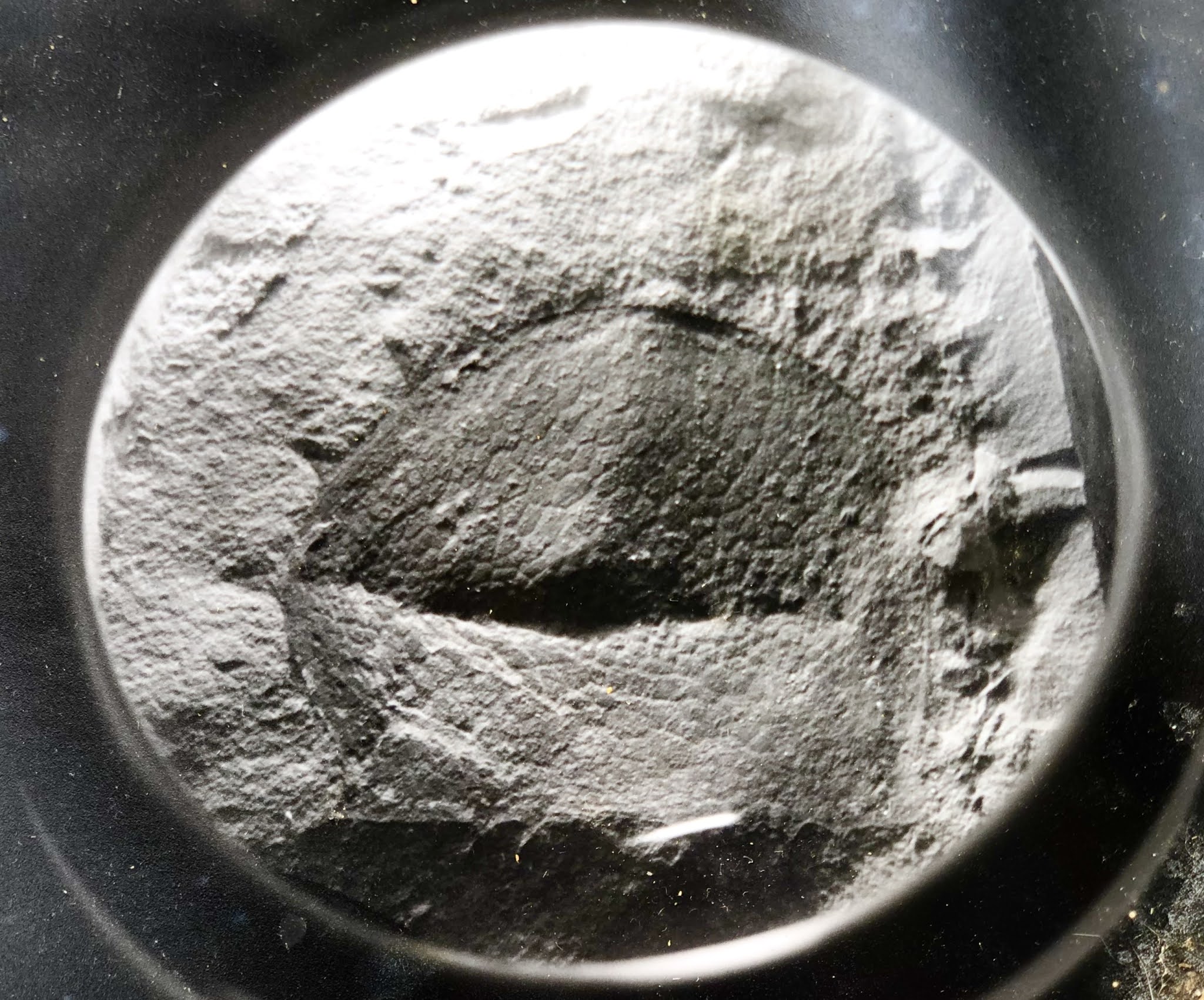
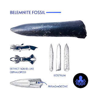
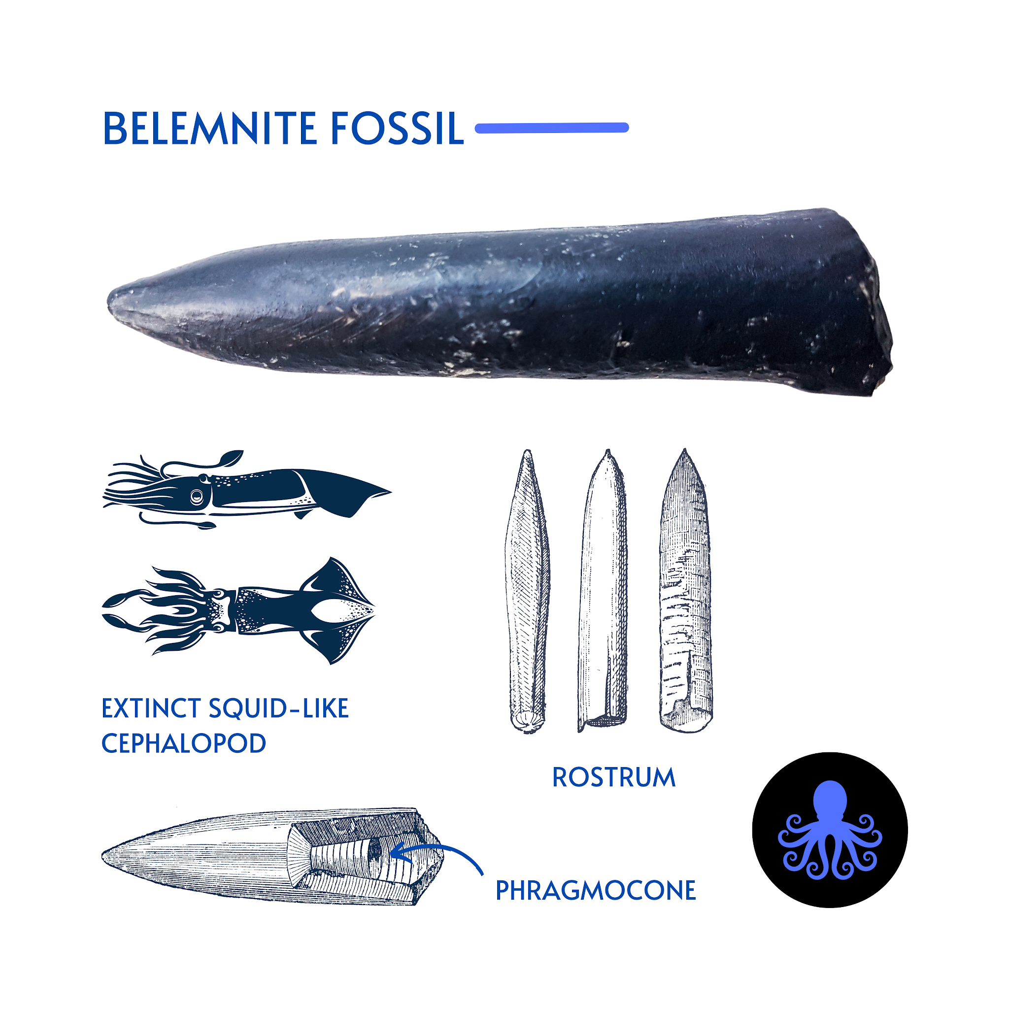
Belemnite Fossils
In my favourite outcrops, you can find large, smooth inflated Jurassic ammonites along with their small grey and brown cousins. 

Further up the road, you will see Cretaceous cigar-shaped squid-like cephalopods called Belemnites, and the bivalve (clam) Buchia — gifts deposited by glaciers. Here are the most common.

Ammonites

Almost all of the ammonite specimens found near Harrison Lake are the toonie sized Cadoceras (Paracadoceras) tonniense with well-preserved outer whorls but flattened inner whorls. We find semi-squished elliptical specimens here, too. If you see a large, smooth, inflated grapefruit-sized ammonite, you are holding a rare prize — a Cadoceras comma ammonite, the macroconch or female of the species.  

Ammonites were predatory, squid-like creatures that lived inside coil-shaped shells. Like other cephalopods, ammonites had sharp, beak-like jaws inside a ring of squid-like tentacles that extended from their shells. They used these tentacles to snare prey — plankton, vegetation, fish and crustaceans — similar to the way a squid or octopus hunts today.

Within their shells, ammonites had a number of chambers called septa filled with gas or fluid, and they were interconnected through a wee air tube. By pushing air in or out, they were able to control their buoyancy. 

These small but mighty marine predators lived in the last chamber of their shell and continuously built new shell material as they grew. As they added each new chamber, they would move their squid-like body down to occupy the final outside chamber.

Interestingly, ammonites from Harrison Lake are quite similar to the ones found within the lower part of the Chinitna Formation near Cook Inlet, Alaska, and Jurassic Point, Kyuquot, on the west coast of Vancouver Island — some of the most beautiful places on Earth. 

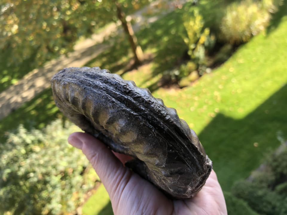
Buchia (bivalve) Clams

The bivalve or clam Buchia are commonly found at Harrison Lake. You will see them cemented together en masse. . They populated Upper Jurassic–Lower Cretaceous waters like a team sport. When they thrived, they really thrived, building up large coquinas of material. Large boulders of Buchia cemented together en masse hitched a ride with the glaciers and were deposited around Harrison Lake. Some kept going and we find similar erratics or glacier-deposited boulders as far south as Washington state. 

Buchia is used as Index Fossils. Index fossils help us to figure out the age of the rock we are looking at because they are abundant, populate an area en masse, and then die out quickly. In other words, they make it easy to identify a geologic time span.

So what does this mean to you? Now, when you are out and about with friends and discover rocks with Buchia, or made entirely of Buchia, you can say, “Oh, this looks to be Upper Jurassic or Lower Cretaceous. Come take a look! We're likely the first to lay eyes on this little clam since dinosaurs roamed the Earth.” 

Fossil Collecting at Harrison Lake Fossil Field Trip — Getting there

This Harrison Lake site is a great day trip from Vancouver or the Fraser Valley. You will need a vehicle with good tires for travel on gravel roads. Search out the route ahead of time and share your trip plan with someone you trust. If you can pre-load the Google Earth map of the area, you will thank yourself. 

Heading east on from Vancouver, it will take you 1.5-2 hours to reach Harrison Mills. 

Access Forestry Road #17 at the northeast end of the parking lot from the Sasquatch Inn at 46001 Lougheed Hwy, Harrison Mills. From there, it will take about an hour to get to the site. Look for signs for the Chehalis River Fish Hatchery to get you started. 

Drive 30 km up Forestry Road #1, and stop just past Hale Creek at 49.5° N, 121.9° W (paleo-coordinates 42.5° N, 63.4° W) on the west side of Harrison Lake. You will see Long Island to your right. 

The first of the yummy fossil exposures are just north of Hale Creek on the west side of the road. Keep in mind that this is an active logging road, so watch your kids and pets carefully. Everyone should be wearing something bright so they can be easily spotted.

How to Spot the Fossils

The fossils here are easily collected—look in the bedrock and in the loose material that gathers in the ditches. Specimens will show up as either dark grey, grey-brown or black. Look for the large, dark-grey boulders the size of smart cars packed with Buchia. 

And while you are at it, be on the lookout for anything that looks like bone. This site is also ripe for marine reptiles—think plesiosaur, mosasaur and elasmosaur. As a citizen scientist and budding palaeontologist, you might just find something new!

What to Know Before You Go

Fill your gas tank and pack a tasty lunch. As with all trips into British Columbia's wild places, dress for the weather. You will need hiking boots, rain gear, gloves, eye protection, and a good geologic hammer and rock (cold) chisel. 

Wear bright clothing and keep your head covered. Slides are common, and you may start a few if you hike the cliffs. If you are with a group, those collecting below may want to consider hardhats in case of rockfall — chunks of rock the size of your fist up to the size of a grapefruit. They pack a punch. 

Bring a colourful towel or something to put your keepers on. Once you set rock down, it can be hard to find again given the terrain. I take the extra precaution of spraying the ends of my hammers and chisels with yellow fluorescent paint, as I have lost too many in the field. You will also want to bring a camera for the blocks of Buchia that are too big to carry home. 

Identifying Your Treasures

When you have finished for the day, compare your treasures to see which ones you would like to keep. In British Columbia, you are a steward of the fossil, which means they belong to the province, but you can keep them safe. You are not allowed to sell or ship them outside British Columbia without a permit. 

Once you get home, wash and identify your finds. Harrison Lake does not have a large variety of fossil fauna, so this should not be difficult. If your find is coiled and round, it is an ammonite. If it is long and straight, it is a belemnite. And if it looks like a wee fat baby oyster, it is Buchia. This is not always true, but mostly true.

What about collecting fossils in all seasons?. Everyone has a preference. I prefer not to collect in the snow, but I have done it. While sunny days are lovely, it can also be easier to see the specimens when the rock is wet. So, do we do this in the rain? Heck, yeah! 

In torrential rain? 

Yes — once you are hooked, but for your casual friends or the kiddos, the answer is likely no. Choose your battles. They may come with you, but a cold day getting soaked is no fun. 

In time, you will find your inner fossil geek — probably with your first find. And that's just the tip of the iceberg. First, it will be you, then your kids, your friends and then your neighbour. Once you start, it is easy to get hooked. Fossil addiction is real, and the only cure is to get out there and do it some more. You've got this!

References and further information:

A. J. Arthur, P. L. Smith, J. W. H. Monger and H. W. Tipper. 1993. Mesozoic stratigraphy and Jurassic palaeontology west of Harrison Lake, southwestern British Columbia. Geological Survey of Canada Bulletin 441:1-62

R. W. Imlay. 1953. Callovian (Jurassic) ammonites from the United States and Alaska Part 2. The Alaska Peninsula and Cook Inlet regions. United States Geological Survey Professional Paper 249-B:41-108

An overview of the tectonic history of the southern Coast Mountains, British Columbia; Monger, J W H; in, Field trips to Harrison Lake and Vancouver Island, British Columbia; Haggart, J W (ed.); Smith, P L (ed.). Canadian Paleontology Conference, Field Trip Guidebook 16, 2011 p. 1-11 (ESS Cont.# 20110248).


Tuesday 4 October 2022

BRITISH COLUMBIA'S GREAT BEARS: NAN

Hiking in BC, both grizzly and black bear sightings are common. 

Nearly half the world's population, some 25,000 Grizzly Bears, roam the Canadian wilderness — of those, 14,000 or more call British Columbia home. 

These highly intelligent omnivores spend their days lumbering along our coastlines, mountains and forests. Or tucking away on logs to enjoy a favourite meal as is the case of the two youngsters here.

Both bear families descend from a common ancestor, Ursavus, a bear-dog the size of a raccoon who lived more than 20 million years ago. Seems an implausible lineage given the size of their very large descendants. 

An average Grizzly weighs in around 800 lbs (363 kg), but a recent find in Alaska tops the charts at 1600 lbs (726 kg). 

This mighty beast stood 12' 6' high at the shoulder, 14' to the top of his head and is one of the largest grizzlies ever recorded — a na̱ndzi.

Adult bears tend to live solo except during mating season. Those looking for love congregate from May to July in the hopes of finding a mate. Through adaptation to shifting seasons, the females' reproductive system delays the implantation of fertilized eggs — blastocysts —until November or December to ensure her healthy pups arrive during hibernation. If food resources were slim that year, the newly formed embryo will not catch or attach itself to her uterine wall and she'll try again next year. 

Females reach mating maturity at 4-5 years of age. They give birth to a single or up to four cubs (though usually just two) in January or February. The newborn cubs are cute little nuggets — tiny, hairless, and helpless — weighing in at 2-3 kilograms or 4-8 pounds. They feast on their mother’s nutrient-dense milk for the first two months of life. The cubs stay with their mamma for 18 months or more. Once fully grown, they can run 56 km an hour, are good at climbing trees and swimming and live 20-25 years in the wild. 

A Grizzly bear encounter inspires a humbling appreciation of just how remarkable these massive beasts are. Knowing their level of intelligence, keen memory and that they have a bite force of over 8,000,000 pascals — enough to crush a bowling ball — inspires awe and caution in equal measure. 

They have an indescribable presence. It is likely because of this that these majestic bears show up often in the superb carvings and work of First Nations artists. I have had close encounters with many bears growing up in the Pacific Northwest, meeting them up close and personal in the South Chilcotins and along our many shorelines. 

First Nation Lore and Language

In the Kwak'wala language of the Kwakiutl First Nations of the Pacific Northwest — or Kwakwaka'wakw, speakers of Kwak'wala — a Grizzly bear is known as na̱n

The ornamental carved Grizzly bear headdress was worn by the comic Dluwalakha Grizzly Bear Dancers, Once more from Heaven, in the Grizzly Bear Dance or Gaga̱lalał, is known as na̱ng̱a̱mł

The Dluwalakha dancers were given supernatural treasures or dloogwi which they passed down from generation to generation. 

In the Hamat'sa Grizzly bear dance, Nanes Bakbakwalanooksiwae, no mask was worn. Instead, the dancers painted their faces red and wore a costume of bearskin or t̓ła̱ntsa̱m and long wooden claws attached to their hands. You can imagine how impressive that sight is lit by the warm flickering flames of firelight during a Winter Dance ceremony.

Smoke of the World / Speaking of the Ancestors — Na̱wiła

Kwaguʼł Winter Dancers — Qagyuhl
Should you encounter a black bear and wish to greet them in Kwak'wala, you would call them t̕ła'yi. Kwakiutl First Nations, Smoke of the World, count Grizzly Bears as an ancestor — along with Seagull, Sun and Thunderbird. 

To tell stories of the ancestors is na̱wiła. Each of these ancestors took off their masks to become human and founded the many groups that are now bound together by language and culture as Kwakwaka’wakw. 

The four First Nations who collectively make up the Kwakiutl are the Kwakiutl (Kwágu7lh), K’umk’utis/Komkiutis, Kwixa/Kweeha (Komoyoi) and Walas Kwakiutl (Lakwilala) First Nations. There is likely blood of the Lawit’sis in there, too, as they inhabited the village site at Tsax̱is/T'sakis, Fort Rupert before the Kwakiutl made it a permanent home. It is where I grew up and I call all who speak Kwak'wala Cousin.

Not all Kwakwaka'wakw dance the Gaga̱lalał, but their ancestors likely attended feasts where the great bear was celebrated. To speak or tell stories of the ancestors is na̱wiła — and Grizzly bear as an ancestor is na̱n helus.

Visiting British Columbia's Great Bears

If you are interested in viewing British Columbia's Great Bears, do check out Indigenous Tourism BC's wonderfully informative website and the culturally-rich wildlife experiences on offer. You will discover travel ideas and resources to plan your next soul-powered adventure. To learn more about British Columbia's Great Bears and the continuing legacy of First Nation stewardship, visit: 

Indigenous Tourism BC: https://www.indigenousbc.com

Great Bear Lodge has been offering tours to view the majestic animals of the Pacific Northwest. They keep both the guests and the animals' comfort and protection in mind. I highly recommend their hospitality and expertise. To see their offerings, visit: www.greatbeartours.com

Image: Group of Winter Dancers--Qagyuhl; Curtis, Edward S., 1868-1952, https://lccn.loc.gov/2003652753. 

Note: The Qagyuhl in the title of this photograph refers to the First Nation group, not the dancers themselves. I think our dear Edward was trying to spell Kwaguʼł and came as close as he was able. In Kwak'wala, the language of the Kwaguʼł or Kwakwakaʼwakw, speakers of Kwak'wala, the Head Winter Dancer is called t̕seḵa̱me' — and to call someone a really good dancer, you would use ya̱'winux̱w

Charmingly, when Edward S. Curtis was visiting Tsaxis/T'sakis, he was challenged to a wrestling competition with a Giant Pacific Octopus, Enteroctopus dofleini. George Hunt (1854-1933) had issued the challenge and laughed himself senseless when Edward got himself completely wrapped up in tentacles and was unable to move. Edward was soon untangled and went on to take many more photos of the First Nations of the Pacific Northwest. Things did not go as well for the octopus or ta̱ḵ̕wa. It was later served for dinner or dzaḵwax̱stala, as it seemed calamari was destined for that night's menu.  


Monday 3 October 2022

FOSSIL HUNTING: NOT FOR THE FAINT OF HEART

Coroniceras sp. from Sayward, British Columbia
This yummy Lower Jurassic ammonite with the creamy dark chocolate colouring is from an all but inaccessible outcrop of the Upper Sinemurian, Bonanza Group,  Harbledownense Zone, Memekay River area, near Sayward, Vancouver Island, British Columbia, Canada. 

This area is home to the We Wai Kai and Wei Wai Kum First Nations and lands of the K'omoks whose culture thrives and reflects the natural rugged beauty of the central island region.

I passed through Sayward earlier this month on the way to northern Vancouver Island. 

It is rugged, remote and beautiful. Think trees and valleys for as far as the eye can see. Some of those hillsides on the horizon contain wonderful fossils, including this Coroniceras sp. with the truly marvellous keel.

By the time these ammonites were being buried in sediment, Wrangellia, the predominately volcanic terrane that now forms Vancouver Island and Haida Gwaii, had made its way to the northern mid-latitudes.

Within the basal part of the sequence, sedimentary beds are found interbedded with lapilli and crystal tuffs. Here you'll see maroon tuffaceous sandstone, orange-grey sandstone, granule sandstone and conglomerate. Within them we find ammonites nestled in with gastropods and pelecypods. 

While the fossiliferous outcrop is quite small, the Bonanza group is much larger, estimated to be at least 1000 metres thick. The site is quite small and in an active logging area, so the window to collect was limited. The drive up the mountain was thrilling as there had just been heavy rains and the road was washed out and narrowed until it was barely the width of our wheelbase and very, very steep. Closer to the top it narrowed to be just shy of the width of the vehicle — thrilling, to say the least. 

So scary that my passengers all got out as there was a high probability of going head-first over the edge. I was navigating by some handwritten field notes and a wee map on a paper napkin that should have read, "park at the bottom and hike up." 

Did we park at the bottom and hike up? No, we did not. 

The torrential rains of the Pacific Northwest had been working their magic on the hillside and slowly washing out the road until it slowly became more of a trail.

At the base of the hillside all looked well. Giddy for the fossils to come, we ventured off with a truck full of enthusiasm. Within 15 minutes of steep elevation gain, we had a wonderful view of the valley below. We were halfway up the mountain before I realized the error of my ways. The road twisted and turned then slowly narrowed to the width of my tires. Too narrow to turn around, so the only way was up. 

Graham Beard from Qualicum Beach was the fellow who showed me the site and drew the wee map for me. I cannot recall everyone on the trip, but Perry Poon was there — he shot a video of the drive up that he described as thrilling. I have never seen it but would like to one day — and so was Patricia Coutts with her lovely Doberman. 

She and I had just done a trip up to Goldbridge where the cliff we were on had turned into a landslide into a ravine so she was feeling understandably cautious about the power of Mother Nature. 

Picture the angle, the hood of my jeep riding high and hiding what remained of the road beneath and a lovely stick shift that made you roll backwards a wee bit with every move to put it into gear. So, without being able to see the very narrow path beneath, I had to just keep going. 

Both Perry and Patricia helped with filling in the potholes so my tires would have something to grip. 

I bent the frame on the jeep heading up and had some explaining to do when I returned it to the car rental place. 

As I recall, I wasn't in my ordinary vehicle but a rental because my car had been stolen the weekend before when I was away with John Fam and Dan Bowen collecting at Jurassic Point, an epic fossil site accessible only by boat on our wild west coast.

Fortuitous timing really, as they stole my car but I had unloaded my precious fossil collecting gear out of the trunk just days before.  

In the end, we found what we were looking for. Memekay yields a mix of ammonites, gastropods and bivalves. 

Many of them are poorly preserved. It was a hell of a ride but well worth the effort as we found some great fossils and with them more information on the palaeontology and geology of Vancouver Island. Just look at the keel on this beauty.

I would share the site information but it is now covered over with debris and inaccessible. One day, this whole region will be developed and the site will be opened up again. Until then, we'll have to enjoy what has been unearthed.

Sunday 2 October 2022

TRUMPET CALLS FROM THE CRETACEOUS

Reconstruction of Prosaurolophus maximus
When this good looking fellow was originally described by Brown, Prosaurolophus maximus was known only from a skull and jaw. Half of the skull was badly weathered at the time of examination, and the level of the parietal was distorted and crushed upwards to the side. 

You can imagine that these deformations in preservation created some grief in the final description.

Prosaurolophus maximus was a large-headed duckbill dinosaur, or hadrosaurid, in the ornithischian family Hadrosauridae.

The most complete Prosaurolophus maximus specimen had a massive skull an impressive 0.9 metres (3.0 ft) long that graced a skeleton about 8.5 metres (28 ft) long. 

He had a small, stout, triangular crest in front of his eyes. The sides of the crest are concave, forming depressions. 

The crest grew isometrically — without changing in proportion — throughout the lifetime of each individual, leading one to wonder if Prosaurolophus had had a soft tissue display structure such as inflatable nasal sacs. We see this feature in hooded seals, Cystophora cristata, who live in the central and western North Atlantic today. Prosaurolophus maximus may have used their inflatable nasal sac for a display to warn a predator or to entice the ladies, attracting the attention of a female.

The different bones of the skull are easily defined with the exception of the parietal and nasal bones. Brown found that the skull of the already described genus Saurolophus was very similar overall, just smaller than the skull of Prosaurolophus maximus. The unique feature of a shortened frontal in lambeosaurines is also found in Prosaurolophus maximus, and the other horned hadrosaurines Brachylophosaurus, Maiasaura, and Saurolophus. Although they lack a shorter frontal, the genera Edmontosaurus and Shantungosaurus share an elongated dentary structure.

Prosaurolophus maximus, Ottawa Museum of Nature
Patches of preserved skin are known from two juvenile specimens, TMP 1998.50.1 and TMP 2016.37.1; these pertain to the ventral extremity of the ninth through fourteenth dorsal ribs, the caudal margin of the scapular blade, and the pelvic region. 

Small basement scales (scales that make up the majority of the skin surface), 3–7 millimetres (0.12–0.28 in) in diameter, are preserved on these patches - this is similar to the condition seen in other saurolophine hadrosaurs.

More uniquely, feature scales (larger, less numerous scales which are interspersed within the basement scales) around 5 millimetres (0.20 in) wide and 29 millimetres (1.1 in) long are found interspersed in the smaller scales in the patches from the ribs and scapula (they are absent from the pelvic patches). 

Similar scales are known from the tail of the related Saurolophus angustirostris (on which they have been speculated to indicate pattern), and it is considered likely adult Prosaurolophus would've retained the feature scales on their flanks like the juveniles.

Image: Three-dimensional reconstruction of Prosaurolophus maximus. Created using the skull reconstructions in the original description as reference. (Fig. 1 and 3 in Brown 1916). According to Lull and Wright (1942), the muzzle was restored too long in its original description. The colours and/or patterns, as with nearly all reconstructions of prehistoric creatures, are speculative. Created & uploaded to Wikipedia by Steveoc 86.

Saturday 1 October 2022

KI'APALANO: STONE BONE AND WATER

Cretaceous Plant Material / Three Brothers Formation
Vancouver has a spectacular mix of mountains, forests, lowlands, inlets and rivers all wrapped lovingly by the deep blue of the Salish Sea. 

When we look to the North Shore, the backdrop is made more spectacular by the Coast Mountains with a wee bit of the Cascades tucked in behind.

If you were standing on the top of the Lion's Gate Bridge looking north you would see the Capilano Reservoir is tucked in between the Lions to the west and Mount Seymour to the east on the North Shore. 

The bounty of that reservoir flows directly into your cup. If you look down from the reservoir you see the Capilano River as it makes its way to the sea and enters Burrard Inlet.

The Capilano River on Vancouver's North Shore flows through the Coast Mountains and our coastal rainforest down to the Capilano watershed enroute to Burrard Inlet. The headwaters are at the top of Capilano up near Furry Creek. They flow down through the valley, adding in rainwater, snowmelt and many tributaries before flowing into Capilano Lake. The lake in turn flows through Capilano Canyon and feeds into the Capilano River.

Today, for many, the Capilano River is the clear, cold water with which we fill our cups. But not so long ago, this Kia’palano, this beautiful river, was the entry point to Homulchesan, traditionally called X̱wemelch'stn, whose name means fast-moving water of fish and the domain of Douglas fir trees and the wild sacred salmon who spawn here.

Capilano Watershed & Reservoir
Sacred First Nations Land

This area was once the exclusive domain of the Coast Salish First Nations —  xʷmə?kʷəyəm (Musqueam), Skwxwú7mesh (Squamish), and səlilwətaɬ (Tsleil-Waututh) Nations until the early 1800s. 

The Musqueam First Nation are traditional hən̓q̓əmin̓əm̓ speaking people who number a strong and thriving 1,300. Many live today on a wee slip of their traditional territory just south of Marine Drive near the mouth of the Fraser River. 

The Secwepemc or Shuswap First Nations are a collective of 17 bands occupying the south-central part of British Columbia. Their ancestors have lived in the interior of BC, the Secwepemc territories, for at least 10,000 years.

The Coast Salish First Nations have lived in this region for thousands of years — from the mouth of the Columbia River in Oregon to north of Bute Inlet. They ancestors of those who live here today braved the cold, following the receding of the ice to forge new roots, build villages and strengthen their connections to this land.   
It is to the Squamish Nation that we owe the name of Capilano which is an anglicized version of Kia'palano. 

In Sḵwx̱wú7mesh snichim or Skwxwú7mesh, their spoken language, Kia'palano/Capilano means beautiful river

Chief Kia'palano (c. 1854-1910) was the Chief of the Squamish Nation from 1895-1910 — and Chief of the territory where this beautiful river flows — Sa7plek.
 
The Cleveland Dam — Capilano River Regional Park

Many things have changed since then, including the Capilano River's path, water levels and sediment deposition. For the salmon who used this path to return home and those who depended on them, life has been forever altered by our hands. The Capilano River still runs with Summer Coho, Spring & Summer Steelhead and Autumn Chinook. The small numbers of Spring/Summer Steelhead are maintained through catch and release and may one day reach their former levels of plenty along Vancouver’s North Shore. Elsewhere, we are beginning to see a rewilding of Vancouver with the return of the salmon to our rivers these past few years. 

It is a hopeful recovery from an amazing creature and their will to not just survive but thrive. Marina Dodis, a local film maker has done a wonderful job of recording that rewilding in her film, The Return. I'll pop a link below for you to watch it. I'm sure you'll enjoy it as much as I did.

We have Ernest Albert Cleveland to thank for the loss of that salmon but can credit him with much of our drinking water as it is caught and stored by the dam that bears his name. It was his vision to capture the bounty from the watershed and ensure it made its way into our cups and not the sea. 

Both the water and a good deal of sediment from the Capilano would flow into Burrard Inlet if not held back by the 91-metre concrete walls of the Cleveland Dam. While it was not Ernest's intention, his vision and dam had a secondary impact. In moving the mouth of the Capilano River he altered the erosion pattern of the North Shore and unveiled a Cretaceous Plant Fossil outcrop that is part of the Three Brothers Formation.

Capilano River Canyon & Regional Park
Know Before You Go

The fossil site is easily accessible from Vancouver and best visited in the summer months when water levels are low. 

The level of preservation of the fossils is quite good. The state in which they were fossilized, however, was not ideal. They look to have been preserved as debris that gathered in eddies in a stream or delta.

There are Cretaceous fossils found only in the sandstone. You will see exposed shale in the area but it does not contain fossil material. 

Interesting, but again not fossiliferous, are the many granitic and limestone boulders that look to have been brought down by glaciers from as far away as Texada Island. Cretaceous plant material (and modern material) found here include Poplar (cottonwood)  Populus sp. Bigleaf Maple, Acer machphyllum, Alder, Alnus rubra, Buttercup  Ranvuculus sp., Epilobrium, Red cedar, Blackberry and Sword fern.

Capilano Fossil Field Trip:

From downtown Vancouver, drive north through Stanley Park and over the Lion’s Gate Bridge. Take the North Vancouver exit toward the ferries. Turn right onto Taylor Way and then right again at Clyde Avenue. Look for the Park Royal Hotel. Park anywhere along Clyde Avenue.

From Clyde Avenue walk down the path to your left towards the Capilano River. Watch the water level and tread cautiously as it can be slippery if there has been any recent rain. Look for beds of sandstone about 200 meters north of the private bridge and just south of the Highway bridge. The fossil beds are just below the Whytecliff Apartment high rises. Be mindful of high water and slippery rocks.

Visiting the Capilano Watershed and Reservoir:

Visitors can see the reservoir from Cleveland Dam at the north end of Capilano River Regional Park. You can also visit the Capilano River Hatchery, operated below Cleveland Dam since 1971.

IN THE HEART OF THE CITY, A WILD MIRACLE AWAITS — THE RETURN, a film by the supremely talented Marina Dodis

There is something astonishing happening in the city of Vancouver. Largely unnoticed amidst vehicle traffic, industrial sites and construction, wild salmon are returning to their ancient spawning grounds.

Once an important salmon bearing area, this watershed became severely degraded as the city grew. The run collapsed and was declared “dead”. As salmon are iconic for people in British Columbia, concerned citizens became engaged. The rewilding has begun to pay off. After disappearing for 80 years, people can now witness the autumn spectacle of these powerful swimmers fighting to reach the streams they hatched in. To have a salmon run taking place within city limits is almost completely unique in a metropolis of this size.

Filmed with a quiet, observing lens over many years, "The Return" takes us into hidden enclaves of wilderness within the city, where tiny salmon smolts shimmer beneath the water's surface. Now that they have come back, their future is in our hands.

Link: https://madodis.wixsite.com/the-return?fbclid=IwAR349gFSZtmb3FN4iZRP6AGLyTH0O7MQnQbY-Prup6Qa0ICUzdhaw3vCkSk