Thursday 10 November 2022

AMMONOIDS, LIMESTONE AND SALT: HALLSTATT

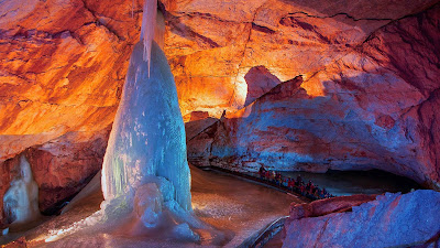
Hallstatt Salt Mines, Austria / Permian Salt Diapir
The Hallstatt Limestone is the world's richest Triassic ammonite unit, yielding specimens of more than 500 ammonite species.

Along with diversified cephalopod fauna  — orthoceratids, nautiloids, ammonoids — we also see gastropods, bivalves, especially the late Triassic pteriid bivalve Halobia (the halobiids), brachiopods, crinoids and a few corals. We also see a lovely selection of microfauna represented. 

For microfauna, we see conodonts, foraminifera, sponge spicules, radiolaria, floating crinoids and holothurian sclerites —  polyp-like, soft-bodied invertebrate echinozoans often referred to as sea cucumbers because of their similarities in size, elongate shape, and tough skin over a soft interior. 

Franz von Hauer’s exhaustive 1846 tome describing Hallstatt ammonites inspired renowned Austrian geologist Eduard Suess’s detailed study of the area’s Mesozoic history. That work was instrumental in Suess being the first person to recognize the former existence of the Tethys Sea, which he named in 1893 after the sister of Oceanus, the Greek god of the ocean. As part of the Northern Limestone Alps, the Dachstein rock mass, or Hoher Dachstein, is one of the large karstic mountains of Austria and the second-highest mountain in the Northern Limestone Alps. It borders Upper Austria and Styria in central Austria and is the highest point in each of those states.

Parts of the massif also lie in the state of Salzburg, leading to the mountain being referred to as the Drei-Länder-Berg or three-state mountain. Seen from the north, the Dachstein massif is dominated by the glaciers with the rocky summits rising beyond them. By contrast, to the south, the mountain drops almost vertically to the valley floor. The karst limestones and dolomites were deposited in our Mesozoic seas. The geology of the Dachstein massif is dominated by the Dachstein-Kalk Formation — the Dachstein limestone — which dates back to the Triassic.

Hallstatt and the Hallstatt Sea, Austria
There were several phases of mountain building in this part of the world pushing the limestone deposits 3,000 metres above current sea level. The rock strata were originally deposited horizontally, then shifted, broken up and reshaped by the erosive forces of ice ages and erosion.

The Hallstatt mine exploits a Permian salt diapir that makes up some of this area’s oldest rock. 

The salt accumulated by evaporation in the newly opened, and hence shallow, Hallstatt-Meliata Ocean. This was one of several small ocean basins that formed in what is now Europe during the late Paleozoic and early Mesozoic when the world’s landmasses were welded together to form the supercontinent Pangea. 

Pangea was shaped like a crescent moon that cradled the famous Tethys Sea. Subduction of Tethyian oceanic crust caused several slivers of continental crust to separate from Pangea, forming new “back-arc basins” (small oceans formed by rifting that is associated with nearby subduction) between the supercontinent and the newly rifted ribbon continents.

The Hallstatt-Meliata Ocean was one such back-arc basin. As it continued to expand and deepen during the Triassic, evaporation ceased and reefs flourished; thick limestone deposits accumulated atop the salt. When the Hallstatt-Meliata Ocean closed in the Late Jurassic, the compression squeezed the low-density salt into a diapir that rose buoyantly, injecting itself into the Triassic limestones above.

The Hallstatt salt diapir and its overlying limestone cap came to rest in their present position in the northern Austrian Alps when they were shoved northward as nappes (thrust sheets) during two separate collision events, one in the Cretaceous and one in the Eocene, that created the modern Alps. It is from the Hallstatt salt diapir that Hallstatt, like so many cities and towns, gets its name.

Deposits of rock salt or halite, the mineral name of sodium chloride with the chemical formula of NaCl, are found and mined around the globe. These deposits mark the dried remains of ancient oceans and seas. Names of rivers, towns and cities in Europe — Salzburg, Halle, Hallstatt, Hallein, La Salle, Moselle — all pay homage to their connection to halite and salt production. The Greek word for salt is hals and the Latin is sal. The Turkish name for salt is Tuz, which we see in the naming of Tuzla, a salt-producing region of northeastern Bosnia-Herzegovina and in the names of towns that dot the coast of Turkey where it meets the Black Sea. Hallstatt with its salt diapir is no exception.

The salt-named town of Hallstatt sits on the shores of the idyllic Hallstätter Sea at the base of the Dachstein massif. Visiting it today, you experience a quaint traditional fishing village built in the typical upper Austrian style. Tourism drives the economy as much as salt as this area of the world is picture-perfect from every angle.

Space is at a minimum in the town. For centuries, every ten years the local cemetery exhumes the bones of those buried there and moves them to an ossuary to make room for new burials. The Hallstatt Ossuary is called Karner, Charnel House, or simply Beinhaus (Bone House). Karners are places of secondary burials. They were once common in the Eastern Alps, but that custom has largely disappeared.

Hallstatt Beinhaus Ossuary, Hallstatt, Austria
A collection of over 700 elaborately decorated skulls rest inside the ossuary. They are lined up on rows of wooden shelves that grace the walls of the chapel. Another 500 undecorated skulls, bare and without any kind of adornment, are stacked in the corners.

Each is inscribed and attached to a record with the deceased's name, profession and date of death. The Bone House is located in a chapel in the basement of the Church of Saint Michael. The church dates from the 12th century CE. 

Decorating the skulls was traditionally the job of the local gravedigger and an honour granted to very few. At the family's request, garlands of flowers were painted on the skulls of deceased as decorative crowns if they were female. The skulls of men and boys were painted wreaths of oak or ivy.

Every building in Hallstatt looks out over the Hallstätter Sea. This beautiful mountain lake considered one of the finest of Austria's Salzkammergut region. It lies at the northern foot of the Dachstein mountain range, sitting eight-and-a-half kilometres long and two kilometres wide. The shoreline is dotted by the villages of  Obertraun, Steeg, and Hallstatt.

The region is habitat to a variety of diverse flora and fauna, including many rare species such as native orchids, in the wetlands and moors in the south and north.

Linked by road to the cities of Salzburg and Graz, Hallstatt and its lake were declared one of the World Heritage sites in Austria in 1997 and included in the Hallstatt-Dachstein Salzkammergut Alpine UNESCO World Heritage Site. The little market village of Hallstatt takes its name from the local salt mine.

Hallstatt, Salzkammergut region, Austria
The town is a popular tourist destination with its quaint shops and terraced cafes. In the centre of town, the 19th-century Evangelical Church of Hallstatt with its tall, slender spire is a lakeside landmark. You can see it here in the photo on the left.

Above the town are the Hallstatt Salt mines located within the 1,030-meter-tall Salzburg Salt Mountain. They are accessible by cable car or a three-minute journey aboard the funicular railway. There is also a wonderful Subterranean Salt Lake.

In 1734, there was a corpse found here preserved in salt. The fellow became known as the Man in Salt. Though no archaeological analysis was performed at the time — the mummy was respectfully reburied in the Hallstatt cemetery — based on descriptions in the mine records, archaeologists suspect the miner lived during the Iron Age. This Old Father, Senos ph₂tḗr, 'ɸatīr 'father' may have been a local farmer, metal-worker, or both and chatted with his friends and family in Celtic or Proto-Celtic.

Salt mining in the area dates back to the Neolithic period, from the 8th to 5th Centuries BC. This is around the time that Roman legions were withdrawing from Britain and the Goths sacked Rome. In Austria, agricultural settlements were dotting the landscape and the alpine regions were being explored and settled for their easy access to valuable salt, chert and other raw materials.

The salt-rich mountains of Salzkammergut and the upland valley above Hallstatt were attractive for this reason. The area was once home to the Hallstatt culture, an archaeological group linked to Proto-Celtic and early Celtic people of the Early Iron Age in Europe, c.800–450 BC.
Bronze Age vessel with cow and calf

In the 19th century, a burial site was discovered with 2,000 individuals, many of them buried with Bronze Age artefacts of amber and ivory.

It was this find that helped lend the name Hallstatt to this epoch of human history. The Late Iron Age, between around 800 and 400 BC, became known as the Hallstatt Period.

For its rich history, natural beauty and breathtaking mountainous geology, Hallstatt is a truly irresistible corner of the world.

Salzbergstraße 1, 4830 Hallstatt.  https://www.salzwelten.at/en/home/

Photo: Bronze vessel with cow and calf, Hallstatt by Alice Schumacher - Naturhistorisches Museum Wien - A. Kern – K. Kowarik – A. W. Rausch – H. Reschreiter, Salz-Reich. 7000 Jahre Hallstatt, VPA 2 (Wien, 2008) Seite 133 Abbildung 6. Hallstatt Village & Ossuary Photos: P. McClure Photography ca. 2015.

Bernoulli D, Jenkyns HC (1974) Alpine, Mediterranean, and Central Atlantic Mesozoic facies in relation to the early evolution of the Tethys. Soc Econ Paleont Mineral Spec Publ 19:129–160

Bernoulli D, Jenkyns H (2009) Ancient oceans and continental margins of the Alpine-Mediterranean Tethys: deciphering clues from Mesozoic pelagic sediments and ophiolites. Sedimentology 56:149–190

Wednesday 9 November 2022

TRACKING THROUGH THE TRIASSIC

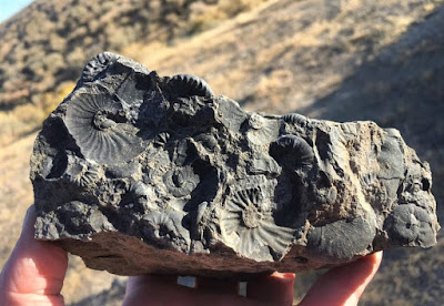
Grambergia sp. Middle Triassic Ammonoid of  BC, Canada
In the early 1980s, Tim Tozer, Geological Survey of Canada was looking at the spread of marine invertebrate fauna in the Triassic of North America. 

In the western terranes of the Cordillera, marine faunas from southern Alaska and Yukon to Mexico are known from the parts that are obviously allochthonous with regard to the North American plates.

Lower and upper Triassic faunas of these areas, as well as some that are today up to 63 ° North, have the characteristics of the lower palaeo latitudes. 

In the western Cordillera, these faunas of the lower paleo latitudes can be found up to 3,000 km north of their counterparts on the American plate. This indicates a tectonic shift of significant magnitude. There are marine triads on the North American plate over 46 latitudes from California to Ellesmere Island. 

For some periods, two to three different faunal provinces can be distinguished. The differences in faunal species are linked, not surprisingly, to their palaeolatitude. They are called LPL, MPL, HPL (lower, middle, higher palaeolatitude).

Nevada provides the diagnostic features of the lower (LPL); northeastern British Columbia that of the middle (MPL) and Sverdrup Basin, the large igneous province on Axel Heiberg Island and Ellesmere Island, Nunavut, Canada near the rifted margin of the Arctic Ocean, that of the higher palaeolatitude (HPL).

A distinction between the provinces of the middle and the higher palaeo-situations can not be made for the lower Triassic and lower Middle Triassic (anise). However, all three provinces can be seen in the deposits of Ladin, Kam and Nor.

In the early 2000s, as part of a series of joint UBC, VIPS and VanPS fossil field trips (and then Chair of the VanPS), I explored much of the lower faunal outcrops of northeastern British Columbia. It was my first time seeing many of British Columbia's Triassic outcrops. Years later, and fueled by seeing paper after paper correlating the faunal assemblages of BC to those of Nevada, I had the very great pleasure of walking through the Nevada strata with John Fam (VanPS, Vice-Chair), Dan Bowen (VIPS, Chair) and Betty Franklin (VIPS, Goddess of Everything and BCPA, Treasurer) — and witnessing first-hand the correlation between the Nevada fauna and those from the Triassic of British Columbia, Canada.

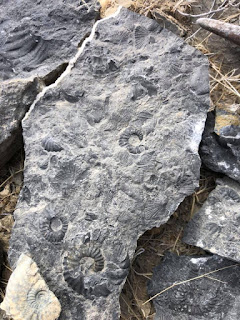
Triassic ammonoids, West Humboldt Mountains, Nevada, USA
The Nevada faunal assemblages are a lovely match. The quality of preservation at localities like Fossil Hill in the Humboldt Mountains of Nevada, perhaps the most famous and important locality for the Middle Triassic (Anisian/Ladinian) of North America, is truly outstanding.

Aside from sheer beauty and spectacular preservation, the ammonoids and belemnites were tucked in cozily with very well preserved ichthyosaur remains.

Tozer's interest in our marine invert friends was their distribution. How and when did certain species migrate, cluster, evolve — and for those that were prolific, how could their occurrence — and therefore significance — aide in an assessment of plate and terrane movements that would help us to determine paleolatitudinal significance. 

I share a similar interest but not exclusive to our cephalopod fauna. The faunal collection of all of the invertebrates holds appeal.

Middle Triassic (Anisian/Ladinian) Fauna
This broader group held an interest for J.P. Smith who published on the marine fauna in the early 1900s based on his collecting in scree and outcrops of the West Humboldt Mountains, Nevada. He published his first monograph on North American Middle Triassic marine invertebrate fauna in 1914.

N. J. Siberling from the US Geological Survey published on these same Nevada outcrops in 1962. His work included nearly a dozen successive ammonite faunas, many of which were variants on previously described species. Both their works would inform what would become a lifelong piecing together of the Triassic puzzle for Tozer.

If one looks at the fauna and the type of sediment, the paleogeography of the Triassic can be interpreted as follows: a tectonically calm west coast of the North American plate that bordered on an open sea; in the area far from the coast, a series of volcanic archipelagos delivered sediment to the adjacent basins. 

Some were lined or temporarily covered with coral wadding and carbonate banks. Deeper pools were in between. The islands were probably within 30 degrees of the triadic equator. They moved away from the coast up to about 5000 km from the forerunner of the East Pacific Ridge. The geographical situation west of the back was probably similar.

Jurassic and later generations of the crust from near the back have brought some of the islands to the North American plate; some likely to South America; others have drifted west, to Asia. There are indications that New Guinea, New Caledonia and New Zealand were at a northern latitude of 30 ° or more during the Triassic period.

The terranes that now form the western Cordillera were probably welded together and reached the North American plate before the end of the Jurassic period.

Marine Triassic occurs on the North American Plate over a latitudinal spread of 46 degrees, from California to Ellesmere Island. At some intervals of time faunas on the Plate permit the discrimination of two or three provinces with distinctively different coeval faunas. 

The faunal differences are evidently related to paleolatitude and the provinces are designated LPL, MPL, HPL (low, mid, high paleolatitude). Nevada provides the diagnostic characters of the LPL province; northeastern British Columbia the MPL; the Sverdrup Basin the HPL. In the Lower Triassic and early Middle Triassic (Anisian), the distinction between the MPL and HPL provinces cannot be made. All three provinces are recognized in the Ladinian, Carnian and Norian deposits.

Juvavites sp. Geological Survey of Canada. Photo: John Fam
In the western tracts of the Cordillera, the part formed of suspect terranes, apparently allochthonous with respect to the North American Plate, marine faunas are known all the way from southern Alaska and Yukon to Mexico.

Lower and Upper Triassic faunas from these terranes, including some which today are at 63 degrees north, have the characters of the LPL province.

Middle Triassic faunas from the terranes, as presently known, do not contribute significant data. In the terranes of the Western Cordillera, LPL faunas were now up to 3,000 km north of their counterparts on the American Plate. Through the fossil fauna assemblages, we can see this level of tectonic displacement.

Taking into account the faunas and the nature of the rocks, the Triassic paleogeography is interpreted as a tectonically quiet west shore for the North American Plate, bordered by an open sea or ocean; then, well off-shore, a series of volcanic archipelagos shedding sediment into adjacent basins. Some were fringed or intermittently covered by coralline shoals and carbonate banks. Deeper basins were in between. The islands probably were within 30 degrees of the Triassic equator and extended offshore for about 5000 km, to the spreading ridge directly ancestral to the East Pacific Rise. The geography west of the spreading ridge was probably comparable.

Jurassic and later generation of crust at the ridge had driven some of the islands into the North American Plate; some probably to South America; others have gone west to Asia. Evidence is given that northern New Guinea, New Caledonia and New Zealand may have been at a north latitude of 30 degrees or more in the Triassic. The terranes now forming the Western Cordillera had probably amalgamated, and reached the North American Plate, before the end of the Jurassic.

At the end of the Rhaetian (part of the Triassic period), most of the ammonites had died out. These are the lovely coiled molluscs you often see in museums and gift shops that sell fossils. They are a particular favourite of mine and they are both beautiful and useful to tell us much about deep time. The Hettangian, a rather poorly understood 3 million year time interval followed the Triassic-Jurassic mass extinction event.

During the Hettangian, the new or  Neoammonites developed quite quickly. Within a million years, a fairly large, diverse selection of genera and species had risen to fill the void. The gap created by the Triassic-Jurassic extinction event was re-filled and our ability to "read the rocks' to understand their continued movement through tectonic plate shifting recommenced.

Alsatites proaries, Hettangian Ammonite
It is during the Hettangian that the smooth shelled ammonite genus Psiloceras first appears. They span the time between 201.3 ± 0.2 Ma and 199.3 ± 0.3 Ma (million years ago). For my European friends, the Hettangian is the time span in which the marine limestone, shales and clay Lias of western Europe were deposited.

This Hettangian ammonite, Alsatites proaries, is a lovely example of the cephalopods cruising our ancient oceans at that time. Alsatites is an extinct genus of cephalopod belonging to the Ammonite subclass. They lived during the Early Jurassic, Hettangian till the Sinemurian and are generally extremely evolute, many whorled with a broad keel. Or, as described by one of my very young friends, he looks like a coiled snake you make in pottery class.

The Hettangian is an interesting little period of our history. It spans the time between 201.3 ± 0.2 Ma and 199.3 ± 0.3 Ma (million years ago). For my European friends, the Hettangian is the time in which the marine limestone, shales and clay Lias of western Europe were deposited. In British Columbia, Canada, we see the most diverse middle and late Hettangian (Early Jurassic) ammonite assemblages in the Queen Charlotte Islands (Haida Gwaii), an archipelago about 50 km off British Columbia's northern Pacific coast. In total, 53 ammonite taxa are described of which Paradasyceras carteri, Franziceras kennecottense, Pleuroacanthites charlottensis, Ectocentrites pacificus and Curviceras haidae are new.

In general, North American Early Jurassic ammonites are of Tethyan affinity or endemic to the eastern Pacific. For this reason, a separate zonation for the Hettangian and Sinemurian of the Western Cordillera of North America was established. Taylor et al. (2001), wrote up and published on much of this early research though, at the time, very little Canadian information was included.

Longridge, L. M., et al. “Three New Species of the Hettangian (Early Jurassic) Ammonite Sunrisites from British Columbia, Canada.” Journal of Paleontology, vol. 82, no. 1, 2008, pp. 128–139. JSTOR, www.jstor.org/stable/20144175. Accessed 27 Jan. 2020.

Tozer, ET (Tim): Marine Triassic faunas of North America: Their significance for assessing plate and terrane movements. Geol Rundsch 71, 1077-1104 (1982). https://doi.org/10.1007/BF01821119

Danner, W. (Ted): Limestone resources of southwestern British Columbia. Montana Bur. Mines & Geol., Special publ. 74: 171-185, 1976.

Davis, G., Monger, JWH & Burchfiel, BC: Mesozoic construction of the Cordilleran “collage”, central British Columbia to central California. Pacific Coast Paleography symposium 2, Soc. Economic Paleontologists and Mineralogists, Los Angeles: 1-32, 1978.

Gibson, DW: Triassic rocks of the Rocky Mountain foothills and front ranges of northeastern British Columbia and west-central Alberta. Geol. Surv. Canada Bull. 247, 1975.

Photo of the large belemnite (Atractites sp?) and ammonites (Sunrisites & Badouxia) from the Lower Jurassic (Late Hettangian), Last Creek Formation (Castle Pass member), Taseko Lakes area, British Columbia, Canada in the collection of the deeply awesome John Fam.

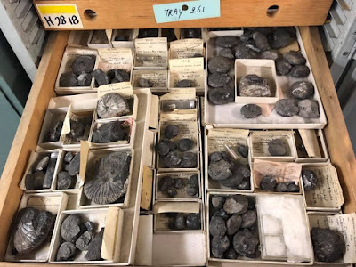
Photo: A drawer of Juvavites sp. in the collections of the Geological Survey of Canada. These rarely seen Upper Triassic (Carnian to Norian) ammonoids were collected over many decades by geologists of the Geological Survey of Canada from Northeastern British Columbia. Photo care of the deeply awesome John Fam.

Photo: Grambergia sp. from the Early Anisian (Middle Triassic) ammonoid biostratigraphy of northeastern British Columbia, Canada. Collection of Fossil Huntress.

Photo: Alsatites proaries, Coll. Reiter, Neoammoniten, 30 July 2011, 19:26:10

Tuesday 8 November 2022

FROM RUSSIA WITH LOVE: CADOCHAMOUSSETIA

From Russia with love. This lovely inflated ammonite is the female macroconch, Cadochamoussetia tschernyschewi (Sokolov, 1912) from the Jurassic, Lower Callovian, Elatmae Zone, Subpatruus Subzone, Stupachenkoi Horizon, Unzha River, Makarev-Manturovo, Kostroma Region, Russia.

This beautiful — fully Бомба — specimen is courtesy of Emil Black and one of the finest in his collection. 

It has a chunkiness that reminds me of the Cadoceras we find in the Pacific Northwest, particularly the macroconch Cadoceras comma from the Callovian Mysterious Creek Formation near Harrison Lake in British Columbia.

In the last decade, the Siberian zonal scale of the Callovian has been considerably revised because of new ammonite collections from the Callovian reference sections in Siberia. Species of Cadoceratinae thought of as exclusively European were recorded for the first time in Siberia. 

Both these newly recovered specimens and recent studies have considerably expanded our knowledge on the taxonomic composition of genera and species of Callovian ammonites and revision of the generic classification and stratigraphic position of genera and species of the family Cardioceratidae. The proposed Lower Callovian ammonite scale largely coincides with the East European scale and correlates with the scales of East Greenland, Arctic Canada, and Alaska (Kniazev et al., 2009, 2010, 2011, 2015; Nikitenko et al., 2013).

Jurassic deposits crop out on the right bank of the
Anabar River between the mouths of the Srednyaya
and Sodiemykha rivers, over a length of about 24 km.

During recent fieldwork at the Middle-Upper Jurassic of the Anabar River basin, a lovely representative ammonite collection was assembled, amongst which was the Early Callovian genus Cadochamoussetia (Mitta, 1996). 

Cadochamoussetia is widespread in East European sections but these beauties were the first recorded specimen of this chunky species from the Anabar.

The genus Cadochamoussetia (Mitta, 1996) was established in European Russian (Gerasimov et al., 1996) and later in England (Navarro et al., 2005).

In the lower Callovian of European Russia, beds with Cadochamoussetia were originally considered part of the Cadochamoussetia subpatruus upper subzone of the Cadoceras elatmae Zone (Mitta, 2000). 

In 2005 and 2009, proposals were made to move these beds from subzone to zone (Gulyaev, 2005, 2009). However, the Unified Regional Stratigraphic Scheme of Jurassic Deposits of the East European Platform (2012), suggested it remained a subzone. The Anabar section contains two species of Сadochamoussetia, which were used as the basis of the Сadochamoussetia tschernyschewi Zone.

In previous papers (Kniazev et al., 2010), considered the composition of the genus Cadoceras as it was interpreted in (Treatise, 1957). 

Several groups of species are now recognized within the genus: Cadoceras elatmae group, including C. frearsi, C. harveyi, C. sublaeve, including species widespread in the Arctic C. tolype, C. emelianzevi, C. septentrionale, C. durum, etc. 

Kniazev et al. proposed assigning a group of Bathonian species Catacadoceras laptievi, C. barnstoni, C. perrarum, C. subcatastoma, and C. nageli.

Photos: Cadochamoussetia tschernyschewi (12 cm) graciously shared by the deeply awesome of Emil Black. He has shared many wonderful specimen photos and stories with me over the years and I am honoured by his generosity in doing so. It is because of him that I am able to share these with all of you! So a collective, Спасибо, мой друг. Spasibo, moy drug. 

I have placed views of this lovely Cadochamoussetia tschernyschewi into a teaching tool that includes the specimen name, length and provenance.

References:
  • The Early Callovian genus Сadochamoussetia (Ammonoidea, Cardioceratidae) in the lower reaches of the Anabar River, Northern Central Siberia; Original Russian Text © V.G. Kniazev, S.V. Meledina, A.S. Alifirov, B.L. Nikitenko, 2017, published in Stratigrafiya, Geologicheskaya Korrelyatsiya, 2017, Vol. 25, No. 4, pp. 26–41.
  • Kniazev, V.G., Meledina, S.V., Alifirirov, A.S., and Kutygin, R.V., The Middle Callovian stage of evlution of Siberian cardioceratids, in Sovremennye problemy izucheniya golovonogikh mollyuskov. Morfologiya, sistematika, evolyutsiya, ekologiya i biostratigrafiya. Vyp. 4 (Current Problems in Study of Cephalopods: Morphology, Systematics, Evolution, Ecology, and Biostratigraphy. Iss. 4), Moscow: Paleontol. Inst. Ross. Akad. Nauk, 2015, pp. 40–45.
  • Meledina, S.V, Correlation of the Bajocian and Bathonian zones in light of new paleontological data, Stratigr. Geol. Correl., 2014, vol. 22, no. 6, pp. 594–605.
  • Kniazev, V.G., Meledina, S.V., Alifirirov, A.S., and Kutygin, R.V., The Middle Callovian stage of evlution of Siberian cardioceratids, in Sovremennye problemy izucheniya golovonogikh mollyuskov. Morfologiya, sistematika, evolyutsiya, ekologiya i biostratigrafiya. Vyp. 
  • If you do not speak Russian that roughly translates to: Current Problems in Study of Cephalopods: Morphology, Systematics, Evolution, Ecology, and Biostratigraphy. Iss. 4, Moscow: Paleontol. Inst. Ross. Akad. Nauk, 2015, pp. 40–45.
  • Meledina, S.V, Correlation of the Bajocian and Bathonian zones in light of new paleontological data, Stratigr. Geol. Correl., 2014, vol. 22, no. 6, pp. 594–605.
  • Treatise on Invertebrate Paleontology. Pt. L. Mollusca 4, Cephalopoda, Ammonoidea, N.Y. Lawrence: Geol. Soc. Amer., Univ. Kansas Press, 1957, vol. 4. TSCreatorProvisualization of Enhanced Geologic Time Scale 2004 database (Vers. 6.2, 2014). http://www.tscreator. org, 2014.
  • Treatise on Invertebrate Paleontology. Pt. L. Mollusca 4, Cephalopoda, Ammonoidea, N.Y. Lawrence: Geol. Soc. Amer., Univ. Kansas Press, 1957, vol. 4. TSCreatorProvisualization of Enhanced Geologic Time Scale 2004 database (Vers. 6.2, 2014). http://www.tscreator. org, 2014.

Monday 7 November 2022

OH, SHINY. FOSSILS PRESERVED IN PYRITE

We sometimes find fossils preserved by pyrite. They are prized as much for their pleasing gold colouring as they are for their scientific value as windows into the past. 

Sometimes folk add a coating of brass to increase the aesthetic appeal — a practice is frowned upon in paleontological communities.

Pyrite, sometimes called Fool's Gold, is a brass-yellow mineral with a bright metallic lustre. I popped a photo of some pyrite below so you can see the characteristic shape of its cubic crystal system.

Fool's Gold has a chemical composition of iron sulfide (FeS2) and is the most common sulfide mineral. It forms at high and low temperatures usually in small quantities, in igneous, metamorphic, and sedimentary rocks. If these sulfide minerals are close at hand when a fossil is forming, they can infuse specimens, replacing their mineral content to beautiful effect.

When we find a fossil preserved with pyrite, it tells us a lot about the conditions on the seabed where the organism died. Pyrite forms when there is a lot of organic carbon and not much oxygen in the vicinity. 

The reason for this is that bacteria in sediment usually respire aerobically (using oxygen), however, when there is no oxygen, they respire without oxygen (anaerobic) typically using sulphate. 

Sulphate is a polyatomic anion with the empirical formula SO2−4. It is generally highly soluble in water. Sulfate-reducing bacteria, some anaerobic microorganisms, such as those living in sediment or near deep-sea thermal vents, use the reduction of sulfates coupled with the oxidation of organic compounds or hydrogen as an energy source for chemosynthesis.

The sulfide mineral Pyrite, FeS2
High quantities of organic carbon in the sediment form a barrier to oxygen in the water. This also works to encourage anaerobic respiration. Anaerobic respiration using sulphate releases hydrogen sulphide, which is one of the major components in pyrite. 

So, when we find a fossil preserved in pyrite, we know that it died and was buried in sediment with low quantities of oxygen and high quantities of organic carbon. 

If you have pyrite specimens and want to stop them from decaying, you can give them a 'quick' soak in water (hour max) then wash them off, dry thoroughly in a warm oven. 

Cool, then soak in pure acetone for a couple of days. Then soak in paraloid, a thermoplastic resin surface coating or acetone for a couple of days. Keep in a sealed container with a desiccant pack afterwards to keep them dry — or leave them out on display to enjoy knowing that the decay will come in time. We do this with cut flowers so why not fossils sometimes.

I have a friend who gives her pyrite fossils on display a quick thumb wipe with vasoline or petroleum jelly. I'm not sure if the hydrocarbons there will play nice over time but it will act as a protective barrier.  

Sunday 6 November 2022

BARNACLES: K'WITA'A

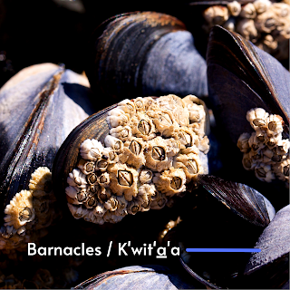
One of the most interesting and enigmatic little critters we find at the seashore are barnacles. They cling to rocks deep in the sea and at the water's edge, closed to our curiosity, their domed mounds like little closed beaks shut to the water and the world.

They choose their permanent homes as larvae, sticking to hard substrates that will become their permanent homes for the rest of their lives. It has taken us a long time to find how they actually stick or what kind of "glue" they were using.

Remarkably, the barnacle glue sticks to rocks in a similar way to how red cells bind together. Red blood cells bind and clot with a little help from some enzymes. 

These work to create long protein fibres that first bind, clot then form a scab. The mechanism barnacles use, right down to the enzyme, is very similar. That's especially interesting as about a billion years separate our evolutionary path from theirs.

So, with the help of their clever enzymes, they can affix to most anything – ship hulls, rocks, and even the skin of whales. If you find them in tidepools, you begin to see their true nature as they open up, their delicate feathery finger-like projections flowing back and forth in the surf.  I confess, having eaten them, that the larger barnacles are also delicious! Both my dad and grandfather were very fond of them. We would head to Balaklava Island where my father was born to choose some of the yummiest of their kin to make a meal of them.

One of my earliest memories is of playing with them in the tidepools on the north end of Vancouver Island. It was here that I learned their many names. In the Kwak'wala language of my family who are Kwakiutl First Nations of the Pacific Northwest, the word for barnacles is k̕wit̕a̱'a — and if it is a very small barnacle it is called t̕sot̕soma — and the Kwak'wala word for glue is ḵ̕wa̱dayu.

Saturday 5 November 2022

RAINBOW AMMONITE: THE UNLIKELY LANDLORD

What you are seeing here is a protuberance extruding from the venter of Quenstedtoceras cf. leachi (Sowerby). It is a pathology in the shell from hosting immature bivalves that shared the seas with these Middle Jurassic, Upper Callovian, Lamberti zone fauna from the Volga River basin. The collecting site is the now inactive Dubki commercial clay quarry and brickyard near Saratov, Russia. 

The site has produced thousands of ammonite specimens. A good 1,100 of those ended up at the Black Hills Institute of Geological Research in Hill City, South Dakota. 

Roughly 1,000 of those are Quenstedtoceras (Lamberticeras) lamberti and the other 100 are a mix of other species found in the same zone. These included Eboraciceras, Peltoceras, Kosmoceras, Grossouvria, Proriceras, Cadoceras and Rursiceras

What is especially interesting is the volume of specimens — 167 Quenstedtoceras (Lamberticeras) lamberti and 89 other species in the Black Hills collection — with healed predation injuries. It seems Quenstedtoceras (Lamberticeras) lamberti are the most common specimens found here and so not surprisingly the most common species found injured. Of the 1,000, 655 of the Quenstedtoceras (Lamberticeras) lamberti displayed some sort of deformation or growth on the shell or had grown in a tilted manner. 

Again, some of the Q. lamberti had small depressions in the centre likely due to a healed bite and hosting infestations of the immature bivalve Placunopsis and some Ostrea

The bivalves thrived on their accommodating hosts and the ammonites carried on, growing their shells right up and over their bivalve guests. This relationship led to some weird and deformities of their shells. They grow in, around, up and over nearly every surface of the shell and seem to have lived out their lives there. It must have gotten a bit unworkable for the ammonites, their shells becoming warped and unevenly weighted. Over time, both the flourishing bivalves and the ammonite shells growing up and over them produced some of the most interesting pathology specimens I have ever seen.    

In the photo here from Emil Black, you can see some of the distorted shapes of Quenstedtoceras sp. Look closely and you see a trochospiral or flattened appearance on one side while they are rounded on the other. 

All of these beauties hail from the Dubki Quarry near Saratov, Russia. The ammonites were collected in marl or clay used in brick making. The clay particles suggest a calm, deep marine environment. One of the lovely features of the preservation here is the amount of pyrite filling and replacement. It looks like these ammonites were buried in an oxygen-deficient environment. 

The ammonites were likely living higher in the water column, well above the oxygen-poor bottom. An isotopic study would be interesting to prove this hypothesis. There's certainly enough of these ammonites that have been recovered to make that possible. It's estimated that over a thousand specimens have been recovered from the site but that number is likely much higher. But these are not complete specimens. We mostly find the phragmocones and partial body chambers. Given the numbers, this may be a site documenting a mass spawning death over several years or generations.

If you fancy a read on all things cephie, consider picking up a copy of Cephalopods Present and Past: New Insights and Fresh Perspectives edited by Neil Landman and Richard Davis. Figure 16.2 is from page 348 of that publication and shows the hosting predation quite well. 

Photos: Courtesy of the deeply awesome Emil Black. These are in his personal collection that I hope to see in person one day. 

It was his sharing of the top photo and the strange anomaly that had me explore more about the fossils from Dubki and the weird and wonderful hosting relationship between ammonites and bivalves. Thank you, my friend!

Friday 4 November 2022

STEMEC SUNTOKUM: FOSSILS OF SOOKE

Stemec suntokum, Sooke Formation
The diving bird you see here is Stemec suntokum, a Fossil Plopterid from Sooke, British Columbia, Canada.

We all dream of finding new species, and new fossil species in particular. This happens more than you think. As impossible as it sounds, it has happened numerous times at many fossils sites in British Columbia including Sooke on Vancouver Island.

The upper Oligocene Sooke Formation outcrops at Muir Beach on southwestern Vancouver Island, British Columbia where it is flanked by the cool, clear waters of the Strait of Juan de Fuca.

While the site has been known since the 1890s, my first trip here was in the early 1990s as part of a Vancouver Paleontological Society (VanPS) fossil field trip. This easy, beach walk locality is a wonderful place to collect fossils and is especially good for families. If you are solar-powered, you will enjoy the sun playing off the surf from May through September. If you are built of hardier stuff, then the drizzle of Spring or Autumn is a lovely, un-people-y time to walk the beachfront.

As well as amazing west coast scenery, the beach site outcrop has a lovely soft matrix with well-preserved fossil molluscs, often with the shell material preserved (Clark and Arnold, 1923).

By the Oligocene ocean temperatures had cooled to near modern levels and the taxa preserved here as fossils bear a strong resemblance to those found living beneath the Strait of Juan de Fuca today. Gastropods, bivalves, echinoids, coral, chitin and limpets are common-ish — and on rare occasions, fossil marine mammals, cetacean and bird bones are discovered.

Fossil Bird Bones 

Back in 2013, Steve Suntok and his family found fossilized bones from a 25-million-year-old wing-propelled flightless diving bird while out strolling the shoreline near Sooke. Not knowing what they had found but recognizing it as significant, the bones were brought to the Royal British Columbia Museum to identify.

The bones found their way into the hands of Gary Kaiser. Kaiser worked as a biologist for Environment Canada and the Nature Conservatory of Canada. After retirement, he turned his eye from our extant avian friends to their fossil lineage. The thing about passion is it never retires. Gary is now a research associate with the Royal British Columbia Museum, published author and continues his research on birds and their paleontological past.

Kaiser identified the well-preserved coracoid bones as the first example from Canada of a Plotopteridae, an extinct family that lived in the North Pacific from the late Eocene to the early Miocene. In honour of the First Nations who have lived in the area since time immemorial and Steve Suntok who found the fossil, Kaiser named the new genus and species Stemec suntokum.

Magellanic Penguin Chick, Spheniscus magellanicus
This is a very special find. Avian fossils from the Sooke Formation are rare. We are especially lucky that the bird bone was fossilized at all.  These are delicate bones and tasty. Scavengers often get to them well before they have a chance and the right conditions to fossilize.

Doubly lucky is that the find was of a coracoid, a bone from the shoulder that provides information on how this bird moved and dove through the water similar to a penguin. It's the wee bit that flexes as the bird moves his wing up and down.

Picture a penguin doing a little waddle and flapping their flipper-like wings getting ready to hop near and dive into the water. Now imagine them expertly porpoising —  gracefully jumping out of the sea and zigzagging through the ocean to avoid predators. It is likely that the Sooke find did some if not all of these activities.

When preservation conditions are kind and we are lucky enough to find the forelimbs of our plotopterid friends, their bones tell us that these water birds used wing-propelled propulsion to move through the water similar to penguins (Hasegawa et al., 1979; Olson and Hasegawa, 1979, 1996; Olson, 1980; Kimura et al., 1998; Mayr, 2005; Sakurai et al., 2008; Dyke et al., 2011).

Kaiser published on the find, along with Junya Watanabe, and Marji Johns. Their work: "A new member of the family Plotopteridae (Aves) from the late Oligocene of British Columbia, Canada," can be found in the November 2015 edition of Palaeontologia Electronica. If you fancy a read, I've included the link below.

The paper shares insights into what we have learned from the coracoid bone from the holotype Stemec suntokum specimen. It has an unusually narrow, conical shaft, much more gracile than the broad, flattened coracoids of other avian groups. This observation has led some to question if it is, in fact, a proto-cormorant of some kind. We'll need to find more of their fossilized lineage to make any additional comparisons.

Sooke, British Columbia and Juan de Fuca Strait
Today, fossils from these flightless birds have been found in outcrops in the United States and Japan (Olson and Hasegawa, 1996). They are bigger than the Sooke specimens, often growing up to two metres.

While we'll never know for sure, the wee fellow from the Sooke Formation was likely about 50-65 cm long and weighed in around 1.72-2.2 kg — so roughly the length of a duck and weight of a small Magellanic Penguin, Spheniscus magellanicus, chick. 

To give you a visual, I have included a photo of one of these cuties here showing off his full range of motion and calling common in so many young.

The first fossil described as a Plotopteridae was from a wee piece of the omal end of a coracoid from Oligocene outcrops of the Pyramid Hill Sand Member, Jewett Sand Formation of California (LACM 8927). Hildegarde Howard (1969) an American avian palaeontologist described it as Plotopterum joaquinensis. Hildegarde also did some fine work in the La Brea Tar Pits, particularly her work on the Rancho La Brea eagles.

In 1894, a portion of a pelagornithid tarsometatarsus, a lower leg bone from Cyphornis magnus (Cope, 1894) was found in Carmanah Group on southwestern Vancouver Island (Wetmore, 1928) and is now in the collections of the National Museum of Canada as P-189401/6323. This is the wee bone we find in the lower leg of birds and some dinosaurs. We also see this same bony feature in our Heterodontosauridae, a family of early and adorably tiny ornithischian dinosaurs — a lovely example of parallel evolution.


While rare, more bird bones have been found in the Sooke Formation over the past decade. In 2013, three avian bones were found in a single year. The first two were identified as possibly being from a cormorant and tentatively identified as Phalacrocoracidae tibiotarsi, the large bone between the femur and the tarsometatarsus in the leg of a bird.

They are now in the collections of the Royal BC Museum as (RBCM.EH2013.033.0001.001 and RBCM.EH2013.035.0001.001). These bones do have the look of our extant cormorant friends but the specimens themselves were not very well-preserved so a positive ID is tricky.

The third (and clearly not last) bone, is a well-preserved coracoid bone now in the collection at the RBCM as (RBCM.EH2014.032.0001.001).

The fossil bird find was the first significant find by the Suntok family but not their last. Just last year, they found part of a fish dental plate was studied by Russian researcher Evgeny Popov who named this new genus and species of prehistoric fish Canadodus suntoki, which translates to the "Tooth from Canada." Perhaps not quite as inspired as Kaiser, but a lovely homage to these Citizen Scientists.

Sooke Fossil Fauna

Along with these rare bird bones, the Paleogene sedimentary deposits of the Carmanah Group on southwestern Vancouver Island have a wonderful diversity of delicate fossil molluscs (Clark and Arnold, 1923). Walking along the beach, look for boulders with white shelly material in them. You'll want to collect from the large fossiliferous blocks and avoid the cliffs. The lines of fossils you see in those cliffs tell the story of deposition along a strandline. Collecting from them is both unsafe and poor form as it disturbs nearby neighbours and is discouraged.

Sooke Formation Gastropods, Photo: John Fam
We find nearshore and intertidal genera such as Mytilus (mussels) and barnacles, as well as more typically subtidal predatory globular moon snails (my personal favourite), surf clams (Spisula, Macoma), and thin, flattened Tellin clams.

The preservation here formed masses of shell coquinas that cemented together but are easily worked with a hammer and chisel. Remember your eye protection and I'd choose wellies or rubber boots over runners or hikers.

You may be especially lucky on your day out. Look for the larger fossil bones of marine mammals and whales that lived along the North American Pacific Coast in the Early Oligocene (Chattian).

Concretions and coquinas on the beach have yielded desmostylid, an extinct herbivorous marine mammal, Cornwallius sookensis (Cornwall, 1922) and 40 cm. skull of a cetacean Chonecetus sookensis (Russell, 1968), and a funnel whale, a primitive ancestor of our Baleen whales. 

A partial lower jaw and molar possibly from a large, bear-like beach-dwelling carnivore, Kolponomos, was also found here. A lovely skull from a specimen of Kolponomos clallamensis (Stirton, 1960) was found 60 km southwest across the Strait of Juan de Fuca in the early Miocene Clallam Formation and published by Lawrence Barnes and James Goedert. That specimen now calls the Natural History Museum of Los Angeles County home and is in their collections as #131148.

Directions to Muir Creek Fossil Site at Sooke: 

From the town of Sooke west of Victoria, follow Highway 14 for about 14 kilometres. Just past the spot where the highway crosses Muir Creek, you will see a gravel parking area on your left. Pull in and park here. 

From the barrier, walk out to the beach and turn right (west) and walk until you see the low yellow-brown sandstone cliffs about 400 metres ahead. 

Look at the grey sandstone boulders on the beach with bits of white flecks in them. The fossil material here will most often be a whitish cream colour. Check for low tide before heading out and choose rubber boots for this beach adventure.

References: 

L. S. Russell. 1968. A new cetacean from the Oligocene Sooke Formation of Vancouver Island, British Colombia. Canadian Journal of Earth Science 5:929-933
Barnes, Lawrence & Goedert, James. (1996). Marine vertebrate palaeontology on the Olympic Peninsula. Washington Geology, 24(3):17-25.

Fancy a read? Here's the link to Gary Kaiser's paper: https://palaeo-electronica.org/content/2015/1359-plotopterid-in-canada. If you'd like to head to the beach site, head to: 48.4°N 123.9°W, paleo-coordinates 48.0°N 115.0°W.

Thursday 3 November 2022

PALAEONTOLOGY OF NEVADA

Time Slows at Berlin-Ichthyosaur State Park
High on the hillside up a long entry road sits the entrance to Berlin-Ichthyosaur State Park in central Nevada.

A worn American flag and sun bleached outbuildings greet you on your way to the outcrops. Away from the hustle and bustle that define the rest of Nevada this place feels remarkably serene. Your eyes squint against the sun as you search for ammonoids and other marine fossil fauna while your nose tends to the assault from the bracing smell of sage brush.

This site holds many stories. The interpretive centre displays wonderful marine reptiles, ichthyosaurs in situ, as you might expect from the name of the park — but it also showcases years of history lovingly tended. This stretch of dry golden low hills dappled with the yellow of creosote and desert grasses is an important locality for our understanding of the Carnian-Norian boundary (CNB) in North America.

The area is known worldwide as one of the most important ichthyosaur Fossil-Lagerstätte because of the sheer volume of remarkably well-preserved, fully articulated (all the sweet bones laid out all in a row...) specimens of Shonisaurus popularis.

Rich ammonoid faunas outcrop in the barren hills of the Upper Triassic (Early Norian, Kerri zone), Luning Formation, West Union Canyon, Nevada. They were studied by N. J. Silberling (1959) and provide support for the definition of the Schucherti and Macrolobatus zones of the latest Carnian — which are here overlain by well-preserved faunas of the earliest Norian Kerri Zone. 

The genus Gonionotites, very common in the Tethys and British Columbia, is for the moment, unknown in Nevada. The Upper Carnian faunas are dominated by Tropitidae, while Juvavitidae are conspicuously lacking. 

Middle Triassic Ammonoids
Despite its importance, no further investigations had been done at this site for a good 50 years. That changed in 2010 when Jim Haggart, Mike Orchard and Paul Smith — all local Vancouverites — collaborated on a project that took them down to Nevada to look at the conodonts and ammonoids. They did a bed-by-bed sampling of ammonoids and conodonts in West Union Canyon during October of that year.

October is an ideal time to do fieldwork in this area. There are a few good weeks between screaming hot and frigid cold. It is also tarantula breeding season so keep your eyes peeled. Those sweet little burrows you see are not from rodents but rather largish arachnids. 

The eastern side of the canyon provides the best record of the Macrolobatus Zone, which is represented by several beds yielding ammonoids of the Tropites group, together with Anatropites div. sp. 

Conodont faunas from both these and higher beds are dominated by ornate metapolygnthids that would formerly have been collectively referred to Metapolygnathus primitius, a species long known to straddle the CNB. Within this lower part of the section, they resemble forms that have been separated as Metapolygnathus mersinensis. Slightly higher, forms close to Epigondolella' orchardi and a single Orchardella n. sp. occur. This association can be correlated with the latest Carnian in British Columbia.

Higher in the section, the ammonoid fauna shows a sudden change and is dominated by Tropithisbites. Few tens of metres above, but slightly below the first occurrence of Norian ammonoids Guembelites jandianus and Stikinoceras, two new species of conodonts (Gen et sp. nov. A and B) appear that also occur close to the favoured Carnian/Norian boundary at Black Bear Ridge, British Columbia. Stratigraphically higher collections continue to be dominated by forms close to M. mersinensis and E. orchardi after BC's own Mike Orchard.

The best exposure of the Kerri Zone is on the western side of the West Union Canyon. Ammonoids, dominated by Guembelites and Stikinoceras div. sp., have been collected from several fossil-bearing levels. Conodont faunas replicate those of the east section. The collected ammonoids fit perfectly well with the faunas described by Silberling in 1959, but they differ somewhat from coeval faunas of the Tethys and Canada. 

The ammonoid fauna paints a compelling picture of Tethyan influence with a series of smoking guns. We see an abundance of Tropitidae in the Carnian, a lack of Pterosirenites in the Norian, copious Guembelites, the Tethyan species G. philostrati, the stratigraphic position of G. clavatus and the rare occurrence of Gonionotites. Their hallelujah moment was likely finding an undescribed species of the thin-shelled bivalve Halobia similar to Halobia beyrichi — the clincher that perhaps seals this deal on Tethyan influence. 

I'll take a boo to see what Christopher McRoberts published on the find. A jolly good idea to have him on this expedition as it would have been easy to overlook if the focus remained solely on the conodonts and ammonoids. McRoberts has published on the much-studied Pardonet Formation up in the Willison Lake Area of Northeastern, British Columbia. He knows a thing or two about Upper Triassic Bivalvia and the correlation to coeval faunas elsewhere in the North American Cordillera, and to the Boreal, Panthalassan and Tethyan faunal realms. 

If you fancy a read, they published a paper: "Towards the definition of the Carnian/Norian Boundary: New data on Ammonoids and Conodonts from central Nevada," which you can find in the proceedings of the 21st Canadian Paleontology Conference; by Haggart, J W (ed.); Smith, P L (ed.); Canadian Paleontology Conference Proceedings no. 9, 2011 p. 9-10.

Fig. 1. Location map of Berlin-Ichthyosaur State Park

Marco Balini, James Jenks, Riccardo Martin, Christopher McRoberts, along with Mike Orchard and Norman Siberling, did a bed by bed sampling in 2013 and published on The Carnian/Norian boundary succession at Berlin-Ichthyosaur State Park (Upper Triassic, central Nevada, USA) and published in January 2014 in Paläontologische Zeitschrift 89:399–433. That work is available for download from ResearchGate. The original is in German, but there is a translation available.

After years of reading about the correlation between British Columbia and Nevada, I had the very great pleasure of walking through these same sections in October 2019 with members of the Vancouver Paleontological Society and Vancouver Island Palaeontological Society. It was with that same crew that I'd originally explored fossil sites in the Canadian Rockies in the early 2000s. Those early trips led to paper after paper and the exciting revelations that inspired our Nevada adventure.

If you plan your own adventure, you'll want to keep an eye out for some of the other modern fauna — mountain lions, snakes, lizards, scorpions, wolves, coyotes, foxes, ground squirrels, rabbits, falcons, hawks, eagles, bobcats, sheep, deer and pronghorns.

Figure One: Location map of Berlin-Ichthyosaur State Park. A detailed road log with access information for this locality is provided in Lucas et al. (2007).

Wednesday 2 November 2022

FOSSIL SALMON OF SKOKOMISH

This toothy specimen is an Oncorhynchus nerka, a Pleistocene Sockeye Salmon from outcrops along the South Fork Skokomish River, Olympic Peninsula, Washington State, USA.

The area is home to the Skokomish — one of nine tribes of the Twana, Coast Salish First Nations in the northern-mid Puget Sound area of western Washington state in the United States. 

Each of the Tribal Nations are known by their locations — Dabop, Quilcene or salt-water people, Dosewallips, Duckabush, Hoodsport, Skokomish or Skoko'bsh, Vance Creek, Tahuya, and Duhlelap or Tule'lalap. The name Skokomish means river people or people of the river in the language of the Twana, sqʷuqʷóbəš or sqWuqWu'b3sH.

Closer to my home farther north in the Pacific Northwest on northern Vancouver Island are the Kwakiutl or Kwakwaka'wakw, speakers of Kwak'wala. Here, sockeye salmon are known as ma̱łik. You would likely recognize these fossils' modern counterparts from their distinctive red bodies and greenish heads. 

Their descendants had been absent from the Skokomish River for more than a decade up to 2014 when construction to augment the negative impact of the Cushman Reservoir was undertaken to restore their natural habitat.

The fossil specimens include individuals with enlarged breeding teeth and worn caudal fins. It is likely that these salmon acted very similar to their modern counterparts with males partaking in competitive and sneaky tactics to gain access to the sexiest (large and red) females who were ready to mate. These ancient salmon had migrated, dug their nests, spawned and defended their eggs prior to their death. For now, we're referring to the species found here as Oncorhynchus nerka, as they have many of the characteristics of sockeye salmon, but also several minor traits of the Pink Salmon, Oncorhynchus gorbuscha.

I had expected to learn that the locality contained a single or just a few partial specimens, but the fossils beds are abundant with large, 45–70 cm, four-year-old adult salmon concentrated in a beautiful sequence of death assemblages.

Oncorhynchus nerka, Pleistocene Sockeye Salmon
Gerald Smith, a retired University of Michigan professor was shown the specimens and recognized them as Pleistocene, a time when the northern part of North America was undergoing a series of glacial advances and retreats that carved their distinctive signature into the Pacific Northwest.

It looks as though this population diverged from the original species about one million years ago, possibly when the salmon were deposited at the head of a proglacial lake impounded by the Salmon Springs advancement of a great glacier known as the Puget lobe of the Cordilleran Ice Sheet. 

Around 17,000 years ago, this 3,000 foot-thick hunk of glacial ice had made its way down from Canada, sculpting a path south and pushing its way between the Cascade and Olympic Mountains. The ice touched down as far south as Olympia, stilled for a few hundred years, then began to melt.

After the ice began melting and retreating north, the landscape slowly changed —  both the land and sea levels rising — and great freshwater lakes forming in the lowlands filled with glacial waters from the melting ice. The sea levels rose quite considerably, about one and a half centimetres per year between 18,000 and 13,000 years ago. The isostatic rebound (rising) of the land rose even higher with an elevation gain of about ten centimetres per year from 16,000 to 12,500 years ago.

Around 14,900 years ago, sea levels had risen to a point where the salty waters of Puget Sound began to slowly fill the lowlands. Both the land and sea continued to rise and by 5,000 years ago, the sea level was about just over 3 meters lower than it is today. The years following were an interesting time in the geologic history of the Pacific Northwest. The geology of the South Fork Skokomish River continued to shift, undergoing a complicated series of glacial damming and river diversions after these salmon remains were deposited.

Today, we find their remains near the head of a former glacial lake at an elevation of 115 metres on land owned by the Green Diamond Company. The first fossil specimens were found back in 2001 by locals fishing for trout along the South Fork Skokomish River.

Upon seeing the fossil specimens, Smith teamed up with David Montgomery of the University of Washington, Seattle, along with N. Phil Peterson and Bruce Crowley, a Late Oligocene Mysticete specialist from the Burke Museum, to complete fieldwork and author a paper.

The fossil specimen you see here is housed in the Burke Museum collection. They opened the doors to their new building and exhibitions in the Fall of 2019. These photos are by the deeply awesome John Fam from a trip to see the newly opened exhibits this year. If you fancy a visit to the Burke Museum, check out their website here: https://www.burkemuseum.org/.

David B. Williams did up a nice piece on historylink.org on the Salmon of the Puget lowland. You can find his work here: https://www.historylink.org/File/20263

If you'd like to read more of the papers on the topic, check out:

  • Smith, G., Montgomery, D., Peterson, N., and Crowley, B. (2007). Spawning sockeye salmon fossils in Pleistocene lake beds of Skokomish Valley, Washington. Quaternary Research, 68(2), 227-238. doi:10.1016/j.yqres.2007.03.007.
  • Easterbrook, D.J., Briggs, N.D., Westgate, J.A., and Gorton, M.P. (1981). Age of the Salmon Springs Glaciation in Washington. Geology 9, 87–93.
  • Hikita, T. (1962). Ecological and morphological studies of the genus Oncorhynchus (Salmonidae) with particular consideration on phylogeny. Scientific Reports of the Hokkaido Salmon Hatchery 17, 1–97.

If you fancy a read of Crowley's work on Late Oligocene Mysticete from Washington State, you can check out:  Crowley, B., & Barnes, L. (1996). A New Late Oligocene Mysticete from Washington State. The Paleontological Society Special Publications, 8, 90-90. doi:10.1017/S2475262200000927

Tuesday 1 November 2022

BUNBLEBEES AND THEIR HAMZAT'SI

This fuzzy yellow and black striped fellow is a bumblebee in the genus Bombus sp., family Apidae. We know him from our gardens where we see them busily lapping up nectar and pollen from flowers with their long hairy tongues.

In the Kwak̓wala language of the Kwakiutl or Kwakwaka'wakw, speakers of Kwak'wala, of the Pacific Northwest, bumblebees are known as ha̱mdzalat̕si — though I wonder if this is actually the word for a honey bee, Apis mellifera, as ha̱mdzat̕si is the word for beehive.

I have a special fondness for all bees and look for them both in the garden and in First Nation art.

Bumblebees habit of rolling around in flowers gives us a sense that these industrious insects are also playful. In First Nation art they provide levity — comic relief along with their cousins the mosquitoes and wasps — as First Nation dancers wear masks made to mimic their round faces, big round eyes and pointy stingers. A bit of artistic license is taken with their forms as each mask may have up to six stingers. The dancers weave amongst the watchful audience and swoop down to playfully give many of the guests a good, albeit gentle, poke. 

Honey bees actually do a little dance when they get back to the nest with news of an exciting new place to forage — truly they do. Bumblebees do not do a wee bee dance when they come home pleased with themselves from a successful foraging mission, but they do rush around excitedly, running to and fro to share their excitement. They are social learners, so this behaviour can also signal those heading out to join them as they head back to the particularly good patch of wildflowers. 

Bumblebees are quite passive and usually sting in defence of their nest or if they feel threatened. Female bumblebees can sting several times and live on afterwards — unlike honeybees who hold back on their single sting as its barbs hook in once used and their exit shears it off, marking their demise.

They are important buzz pollinators both for our food crops and our wildflowers. Their wings beat at 130 times or more per second, literally shaking the pollen off the flowers with their vibration. 

And they truly are busy bees, spending their days fully focussed on their work. Bumblebees collect and carry pollen and nectar back to the nest that may be as much as 25% to 75% of their body weight. 

And they are courteous — as they harvest each flower, they mark them with a particular scent to help others of their group know that the nectar is gone. 

The food they bring back to the nest is eaten to keep the hive healthy but is not used to make honey as each new season's queen bees hibernate over the winter and emerge reinvigorated to seek a new hive each Spring. She will choose a new site, primarily underground depending on the bumblebee species, and then set to work building wax cells for each of her fertilised eggs. 

Bumblebees are quite hardy. The plentiful hairs on their bodies are coated in oils that provide them with natural waterproofing. They can also generate more heat than their smaller, slender honey bee cousins, so they remain productive workers in cooler weather.    

We see the first bumblebees arise in the fossil record 100 million years ago and diversify alongside the earliest flowering plants. Their evolution is an entangled dance with the pollen and varied array of flowers that colour our world. 

We have found many wonderful examples within the fossil record, including a rather famous Eocene fossil bee found by a dear friend and naturalist who has left this Earth, Rene Savenye.

His namesake, H. Savenyei, is a lovely fossil halictine bee from Early Eocene deposits near Quilchena, British Columbia — and the first bee body-fossil known from the Okanagan Highlands — and indeed from Canada. 

It is a fitting homage, as bees symbolize honesty, playfulness and willingness to serve the community in our local First Nation lore and around the world — something Rene did his whole life.

Monday 31 October 2022

VISITING BERLIN-ICHTHYOSAUR STATE PARK

At least 37 incomplete fossil specimens of the marine reptile have been found in hard limestone deposits of the Luning Formation, in far northwestern Nye County of Nevada. 

This formation dates to the late Carnian age of the late Triassic period when present-day Nevada and parts of the west were covered by an ancient ocean.

The first researcher to recognize the Nevada fossil specimens as ichthyosaurs was Siemon W. Muller of Stanford University. 

Muller had the work of Sir Richard Owen to build upon from Owen's 1840 publications. That being said, there are very few contenders for a species that boasts vertebrae over a foot wide and weighing in at almost 10 kg or 21 lbs. 

Muller contacted the University of California Museum of Paleontology at Berkeley. Surface collecting by locals continued at the site but no major excavation was planned.

Almost a quarter of a century after Muller's initial correspondence to the UCMP, Dr. Charles L. Camp received correspondence further detailing the finds from a lovely Mrs. Margaret Wheat of Fallon. She wrote to Camp in September of 1928 to say that she'd been giving the quarry section a bit of a sweep, as you do, and had uncovered a nice aligned section of vertebrae with her broom. The following year, Dr. Charles L. Camp went out to survey the finds and began working on the specimens, his first field season of many, in 1954.

Back in the 1950s, these large marine reptiles were rumoured to be "marine monsters," as the concept of an ichthyosaur was not well understood by the local townsfolk. Excitement soon hit West Union Canyon as the quarry began to reveal the sheer size of these mighty beasts. In the end, the ichthyosaur bones were left in situ to better understand how they were laid down over 200 million years ago.

Camp continued to work with Wheat at the site and brought on Sam Welles to help with excavations. The team understood the need for protection at the site. They canvassed the Nevada Legislature to establish the Ichthyosaur Paleontological State Monument. You can one of the Park Rangers above giving a tour within the lovely building they built on the site to protect the fossils.

In 1957, the site was incorporated into the State Park System and Berlin-Ichthyosaur State Park was born. The park Twenty years later, in 1977, the population of Nevada weighed in and the Legislature designated Shonisaurus popularis as the State Fossil of Nevada.

Know Before You Go — Berlin-Ichthyosaur State Park

This is a wonderful place to explore for a very reasonable sum of $5.00 US. Open year-round (though check regarding accessibility during Covid). They have accessible outcrops just outside the park boundary where you can collect ammonoid fossils. 

Contact information: Tel: 775-964-2440 / Email: bisp@parks.nv.gov. 

Address: State Route 844, Austin, NV 89310, United States. Area: 4.58 km². Elevation: 6,975 ft (2,126 m); Tel: +1 775-964-2440; http://parks.nv.gov/parks/berlin-ichthyosaur

Sunday 30 October 2022

NOOTKA FOSSILS & FIRST NATIONS HISTORY

Nootka Fossil Field Trip. Photo: John Fam
The rugged west coast of Vancouver Island offers spectacular views of a wild British Columbia. Here the seas heave along the shores slowly eroding the magnificent deposits that often contain fossils. 

Just off the shores of Vancouver Island, east of Gold River and south of Tahsis is the picturesque and remote Nootka Island.

This is the land of the proud and thriving Nuu-chah-nulth First Nations who have lived here always

Always is a long time, but we know from oral history and archaeological evidence that the Mowachaht and Muchalaht peoples lived here, along with many others, for many thousands of years — a time span much like always

While we know this area as Nootka Sound and the land we explore for fossils as Nootka Island, these names stem from a wee misunderstanding. 

Just four years after the 1774 visit by Spanish explorer Juan Pérez — and only a year before the Spanish established a military and fur trading post on the site of Yuquot — the Nuu-chah-nulth met the Englishman, James Cook.  

Captain Cook sailed to the village of Yuquot just west of Vancouver Island to a very warm welcome. He and his crew stayed on for a month of storytelling, trading and ship repairs. Friendly, but not familiar with the local language, he misunderstood the name for both the people and land to be Nootka. In actual fact, Nootka means, go around, go around

Two hundred years later, in 1978, the Nuu-chah-nulth chose the collective term Nuu-chah-nulth — nuučaan̓uł, meaning all along the mountains and sea or along the outside (of Vancouver Island) — to describe themselves. 

It is a term now used to describe several First Nations people living along western Vancouver Island, British Columbia. 

It is similar in a way to the use of the United Kingdom to refer to the lands of England, Scotland and Wales — though using United Kingdom-ers would be odd. Bless the Nuu-chah-nulth for their grace in choosing this collective name.  

An older term for this group of peoples was Aht, which means people in their language and is a component in all the names of their subgroups, and of beautiful locations in this region  — Yuquot, Mowachaht, Kyuquot, Opitsaht. While collectively, they are the Nuu-chah-nulth, be interested in their more regional name should you meet them. 

But why does it matter? If you have ever mistakenly referred to someone from New Zealand as an Aussie or someone from Scotland as English, you have likely been schooled by an immediate — sometimes forceful, sometimes gracious — correction of your ways. The best answer to why it matters is because it matters.

Each of the subgroups of the Nuu-chah-nulth viewed their lands and seasonal migration within them (though not outside of them) from a viewpoint of inside and outside. Kla'a or outside is the term for their coastal environment and hilstis for their inside or inland environment.

It is to their kla'a that I was most keen to explore. Here, the lovely Late Eocene and Early Miocene exposures offer up fossil crab, mostly the species Raninid, along with fossil gastropods, bivalves, pine cones and spectacularly — a singular seed pod. These wonderfully preserved specimens are found in concretion along the foreshore where time and tide erode them out each year.

Five years after Spanish explorer Juan Pérez's first visit, the Spanish built and maintained a military post at Yuquot where they tore down the local houses to build their own structures and set up what would become a significant fur trade port for the Northwest Coast — with the local Chief Maquinna's blessing and his warriors acting as middlemen to other First Nations. 

Following reports of Cook's exploration British traders began to use the harbour of Nootka (Friendly Cove) as a base for a promising trade with China in sea-otter pelts but became embroiled with the Spanish who claimed (albeit erroneously) sovereignty over the Pacific Ocean. 

Dan Bowen searching an outcrop. Photo: John Fam
The ensuing Nootka Incident of 1790 nearly led to war between Britain and Spain (over lands neither could actually claim) but talk of war settled and the dispute was settled diplomatically. 

George Vancouver on his subsequent exploration in 1792 circumnavigated the island and charted much of the coastline. His meeting with the Spanish captain Bodega y Quadra at Nootka was friendly but did not accomplish the expected formal ceding of land by the Spanish to the British. 

It resulted however in his vain naming the island "Vancouver and Quadra." The Spanish captain's name was later dropped and given to the island on the east side of Discovery Strait. Again, another vain and unearned title that persists to this day.

Early settlement of the island was carried out mainly under the sponsorship of the Hudson's Bay Company whose lease from the Crown amounted to 7 shillings per year — that's roughly equal to £100.00 or $174 CDN today. Victoria, the capital of British Columbia, was founded in 1843 as Fort Victoria on the southern end of Vancouver Island by the Hudson's Bay Company's Chief Factor, Sir James Douglas. 

With Douglas's help, the Hudson's Bay Company established Fort Rupert on the north end of Vancouver Island in 1849. Both became centres of fur trade and trade between First Nations and solidified the Hudson's Bay Company's trading monopoly in the Pacific Northwest.

The settlement of Fort Victoria on the southern tip of Vancouver Island — handily south of the 49th parallel — greatly aided British negotiators to retain all of the islands when a line was finally set to mark the northern boundary of the United States with the signing of the Oregon Boundary Treaty of 1846. Vancouver Island became a separate British colony in 1858. British Columbia, exclusive of the island, was made a colony in 1858 and in 1866 the two colonies were joined into one — becoming a province of Canada in 1871 with Victoria as the capital.

Dan Bowen, Chair of the Vancouver Island Palaeontological Society (VIPS) did a truly splendid talk on the Fossils of Nootka Sound. With his permission, I have uploaded the talk to the ARCHEA YouTube Channel for all to enjoy. Do take a boo, he is a great presenter. Dan also graciously provided the photos you see here. The last of the photos you see here is from a VIPS Nootka Fossil Field Trip. We head out each year as the people, scenery, wildlife and fossils are amazing. Photo: John Fam, Vice-Chair, Vancouver Paleontological Society (VanPS).

Know Before You Go — Nootka Trail

The Nootka Trail passes through the traditional lands of the Mowachaht/Muchalat First Nations who have lived here since always. They share this area with humpback and Gray whales, orcas, seals, sea lions, black bears, wolves, cougars, eagles, ravens, sea birds, river otters, insects and the many colourful intertidal creatures that you'll want to photograph.

This is a remote West Coast wilderness experience. Getting to Nootka Island requires some planning as you'll need to take a seaplane or water taxi to reach the trailhead. The trail takes 4-8 days to cover the 37 km year-round hike. The peak season is July to September. Permits are not required for the hike. 

Access via: Air Nootka floatplane, water taxi, or MV Uchuck III

  • Dan Bowen, VIPS on the Fossils of Nootka: https://youtu.be/rsewBFztxSY
  • https://www.thecanadianencyclopedia.ca/en/article/sir-james-douglas
  • file:///C:/Users/tosca/Downloads/186162-Article%20Text-199217-1-10-20151106.pdf
  • Nootka Trip Planning: https://mbguiding.ca/nootka-trail-nootka-island/#overview