Sunday 8 October 2023

FOSSILS OF TURTLE ISLAND'S EAST KOOTENAY REGION

Tanglefoot Mountain. Photo: Dan Bowden
The East Kootenay region on the south-eastern edge of British Columbia is a land of colossal mountains against a clear blue sky. 

That is not strictly true, of course, as this area does see its fair share of rain and temperature extremes — but visiting in the summer every view is a postcard of mountainous terrain.

Rocks from deep within the Earth's crust underlie the entire East Kootenay region and are commonly exposed in the area's majestic mountain peaks, craggy rocky cliffs, glaciated river canyons, and rock cuts along the highways. Younger Ice Age sediments blanket much of the underlying rock.

I have been heading to the Cranbrook and Fernie area since the early 1990s. My interest is the local geology and fossil history that these rocks have to tell. I am also drawn to the warm and welcoming locals who share a love for the land and palaeontological treasures that open a window to our ancient past.  

Cranbrook is the largest community in the region and is steeped in mining history and the opening of the west by the railway. It is also a stone's throw away from Fort Steele and the Lower Cambrian exposures of the Eager Formation. These fossil beds rival the slightly younger Burgess Shale fauna and while less varied, produce wonderful examples of olenellid trilobites and weird and wonderful arthropods nearly half a billion years old. 

Labiostria westriopi, McKay Group
The Lower Cambrian Eager Formation outcrops at a few localities close to Fort Steele, many known since the early 1920s, and up near Mount Grainger near the highway. 

Further east, the Upper Cambrian McKay Group near Tanglefoot Mountain is a palaeontological delight with fifteen known outcrops that have produced some of the best-preserved and varied trilobites in the province — many of them new species. 

The McKay Formation also includes Ordovician outcrops sprinkled in for good measure.

Other cities in the area and the routes to and from them produce other fossil fauna from Kimberley to Fernie and the district municipality of Invermere and Sparwood. This is an arid country with native grasslands and forests of semi-open fir and pine. Throughout there are a host of fossiliferous exposures from Lower Cretaceous plants to brachiopods. 

The area around Whiteswan Lake has wonderful large and showy Ordovician graptolites including Cardiograptus morsus and Pseudoclimacograptus angustifolius elongates — some of our oldest relatives. A drive down to Flathead will bring you to ammonite outcrops and you can even find Eocene fresh-water snails in the region. 

The drive from Cranbrook to Fernie is about an hour and change through the Cambrian into the Devonian which flip-flops and folds over revealing Jurassic exposures. On my last visit, I made the trip with local geologist Guy Santucci who swings around the hairpin bends with panache. He is a delight to travel with and interspersed great conversation with tasty bits of information on the local geology.

Fernie Ichthyosaur Excavation, 1916
The Crowsnest Highway into Fernie follows Mutz Creek. From the highway, you can see the Fernie Group and the site along the Elk River where an ichthyosaur was excavated in 1916. 

The Fernie Formation is Jurassic. It is present in the western part of the Western Canada Sedimentary Basin in western Alberta and northeastern British Columbia. 

It takes its name from the town of Fernie, British Columbia, and was first defined by W.W. Leach in 1914. The town of Fernie is rimmed by rugged mountains tipped with Devonian marine outcrops. In essence, all these mountains are upside down with the oldest layers flipped to the top and a good 180 million years older than those they sit upon. 

Before they were mountains, these sedimentary rocks were formed as sediment collected in a shallow sea or inland basin. About 360 million years ago, the rocks that you see in Fernie today were down near the equator. They road tectonic plates, pushing northeast smashing into the coastline of what would become British Columbia. A little push here, shove there — compression and thrust faulting — and the rock was rolled over on its head — repeatedly. But that is how mountains are often formed, though not usually pushed so hard that they flip over. But still, it is a slow, relentless business. 

Cretaceous Plant Material, Fernie, BC
Within Fernie, there are small exposures of Triassic and Jurassic marine outcrops. East of the town there are Cretaceous plant sites, and of course, the Jurassic 1.4-metre Titanites occidentalis ammonite up on Coal Mountain.

Once up at the fossil exposures we begin to look for treasures. Over the next four or five hours, as the heat of the day sets in, we find block after block of dark brown to beige Cretaceous material embedded with coal seams and lithified fossil remains.

The regional district's dominant landform is the Rocky Mountain Trench, which is flanked by the Purcell Mountains and the Rocky Mountains on the east and west, and includes the Columbia Valley region. The southern half of which is in the regional district — its northern half is in the Columbia-Shuswap Regional District. 

The regional district of Elk Valley in the southern Rockies is the entryway to the Crowsnest Pass and an important coal-mining area. 

Other than the Columbia and Kootenay Rivers, whose valleys shape the bottomlands of the Rocky Mountain Trench, the regional districts form the northernmost parts of the basins of the Flathead, Moyie and Yahk Rivers. 

The Moyie and Yahk are tributaries of the Kootenay, entering it in the United States, and the Flathead is a tributary of the Clark Fork into Montana.

Photo One: Tyaughton Mountain, Mckay Group taken by Dan Bowden via drone; Photo Two: Labiostria westriopi, Upper Cambrian McKay Group, Site ML (1998); John Fam Collection; Photo Three: Ichthyosaur Excavation, Fernie, British Columbia, 1916; Photo Four: Cretaceous Plant Fossils, east of Fernie towards Coal Mountain. The deeply awesome Guy Santucci as hand-model for scale. 

Saturday 7 October 2023

QUINTUS SERTORIOUS AND THE MYTH OF THE GIANT OGRE

Tetralophodon
During the Miocene and Pliocene, 12-1.6 million years ago, a diverse group of extinct proboscideans, elephant-like animals walked the Earth.

Most of these large beasts had four tusks and likely a trunk similar to modern elephants. They were creatures of legend, inspiring myths and stories of fanciful creatures to the first humans to encounter them.

Beyond our Neanderthal friends, one such fellow was Quintus Sertorius, a Roman statesman come general, who grew up in Umbria. Born into a world at war just two years before the Romans sacked Corinth to bring Greece under Roman rule, Quintus lived much of his life as a military man far from his native Norcia. Around 81 BC, he travelled to Morocco, the land of opium, massive trilobites and the birthplace of Antaeus, the legendary North African ogre who was killed by the Greek hero Heracles.

The locals tell a tale that Quintus requested proof of Antaeus, hard evidence he could bring back to Rome to support their tales so they took him to a mound near Tingis, the ancient name for Tangier, Morocco. It was here they unearthed the bones of an extinct elephantoid, Tetralophodon.

Tetralophodon bones are large and skeletons singularly impressive. Impressive enough to be taken for something else entirely. By all accounts, these proboscidean remains were that of the mythical giant, Antaeus, son of the gods Poseidon and Gaea and were thus reported back to Rome as such. Antaeus went on to marry the goddess Tinge and it is from her, in part, that Tangier in northwestern Morocco gets its name. Together, Antaeus and Tinge had a son, Sophax. He is credited with having the North Africa city take her name. Rome was satisfied with the find. It would be hundreds of years later before the bones true ancestry was known and in that time, many more wonderful ancient proboscideans remains were unearthed..

There were other early proboscideans, of course. The earliest known proboscidean is Eritherium, followed by Phosphatherium, a small animal about the size of a fox. Both date from late Paleocene deposits of Morocco.

Proboscideans evolved in Africa, where they increased in size and diversity during the Eocene and early Oligocene. Several primitive families from these epochs have been described, including the Numidotheriidae, Moeritheriidae, and Barytheriidae, all found exclusively in Africa. 

The Anthracobunidae from the Indian subcontinent were also believed to be a family of proboscideans, but were excluded from the Proboscidea by Shoshani and Tassy (2005) and have more recently been assigned to the Perissodactyla.

When Africa became connected to Europe and Asia after the shrinking of the Tethys Sea, proboscideans migrated into Eurasia, with some families eventually reaching the Americas. Proboscideans found in Eurasia as well as Africa include the Deinotheriidae, which thrived during the Miocene and into the early Quaternary, Stegolophodon, an early genus of the disputed family Stegodontidae; the highly diverse Gomphotheriidae and Amebelodontidae; and the much loved Mammutidae, or mastodons.

I traveled and hiked through much of Morocco to explore the countryside, ancient Roman ruins and many splendid outcrops when I was eighteen. I wish I had known more of the fossil sites before that trip but many had yet to be discovered. I will share more of those stories — and there are plenty — in future posts.

Photo: Henan Geological Museum, Zhengzhou, China. Complete indexed photo collection at WorldHistoryPics.com.

Thursday 5 October 2023

FOSSILS AND FIRST NATIONS OF EASTERN CANADA

Elpistostege watsoni

In the late 1930s, our understanding of the transition of fish to tetrapods — and the eventual jump to modern vertebrates — took an unexpected leap forward. The evolutionary a'ha came from a single partial fossil skull found on the shores of a riverbank in Eastern Canada. 

Meet the Stegocephalian, Elpistostege watsoni, an extinct genus of finned tetrapodomorphs that lived during the Late Givetian to Early Frasnian of the Late Devonian — 382 million years ago. 

Elpistostege watsoni — perhaps the sister taxon of all other tetrapods — was first described in 1938 by British palaeontologist and elected Fellow of the Royal Society of London, Thomas Stanley Westoll. Westoll's research interests were wide-ranging. He was a vertebrate palaeontologist and geologist best known for his innovative work on Palaeozoic fishes and their relationships with tetrapods. 

As a specialist in early fish, Westoll was asked to interpret that single partial skull roof discovered at the Escuminac Formation in Quebec, Canada. His findings and subsequent publication named Elpistostege watsoni and helped us to better understand the evolution of fishes to tetrapods — four-limbed vertebrates — one of the most important transformations in vertebrate evolution. 

Hypotheses of tetrapod origins rely heavily on the anatomy of but a few tetrapod-like fish fossils from the Middle and Late Devonian, 393–359 million years ago. These taxa — known as elpistostegalians — include Panderichthys, Elpistostege and Tiktaalik — none of which had yet to reveal the complete skeletal anatomy of the pectoral fin. 

Elpistostege watsoni
None until 2010 that is, when a complete 1.57-metre-long articulated specimen was found and described by Richard Cloutier et al. in 2020. 

The specimen helped us to understand the origin of the vertebrate hand. Stripped from its encasing stone, it revealed a set of paired fins of Elpistostege containing bones homologous to the phalanges (finger bones) of modern tetrapods and is the most basal tetrapodomorph known to possess them. 

Once the phalanges were uncovered, prep work began on the fins. The fins were covered in wee scales and lepidotrichia (fin rays). The work was tiresome, taking more than 2,700 hours of preparation but the results were thrilling. 

Origin of the Vertebrate Hand
We could now clearly see that the skeleton of the pectoral fin has four proximodistal rows of radials — two of which include branched carpals — as well as two distal rows organized as digits and putative digits. 

Despite this skeletal pattern — which represents the most tetrapod-like arrangement of bones found in a pectoral fin to date blurring the line between fish and land vertebrates — the fin retained lepidotrichia (those wee fin rays) distal to the radials. 

This arrangement confirmed an age-old question — showing us for the first time that the origin of phalanges preceded the loss of fin rays, not the other way around.

E. watsoni is very closely related to Tiktaalik roseae found in 2004 in the Canadian Arctic — a tetrapodomorpha species also known as a Choanata. These were advanced forms transitional between fish and the early labyrinthodonts playfully referred to as fishapods — half-fish, half-tetrapod in appearance and limb morphology. 

Up to that point, the relationship of limbed vertebrates (tetrapods) to lobe-finned fish (sarcopterygians) was well known, but the origin of major tetrapod features remained obscure for lack of fossils that document the sequence of evolutionary changes — until Tiktaalik. While Tiktaalik is technically a fish, this fellow is as far from fish-like you can be and still be a card-carrying member of the group. 

Tiktaalik roseae
Complete with scales and gills, this proto-fish lacked the conical head we see in modern fish but had a rather flattened triangular head more like that of a crocodile. 

Tiktaalik had scales on its back and fins with fin webbing but like early land-living animals, it had a distinctive flat head and neck. He was a brawny brute. The shape of his skull and shoulder look part fish and part amphibian.

The watershed moment came as Tiktaalik was prepped. Inside Tiktaalik's fins, we find bones that correspond to the upper arm, forearm and even parts of the wrist — all inside a fin with webbing — remarkable! 

Its fins have thin ray bones for paddling like most fish, but with brawny interior bones that gave Tiktaalik the ability to prop itself up, using his limbs for support. I picture him propped up on one paddle saying, "how you doing?" 

Six years after Tiktaalik was discovered by Neil Shubin and team in the ice-covered tundra of the Canadian Arctic on southern Ellesmere Island, a team working the outcrops at Miguasha on the Gaspé Peninsula discovered the only fully specimen of E. watsoni found to date — greatly increasing our knowledge of this finned tantalizingly transitional tetrapodomorph. 

E. watsoni fossils are rare — this was the fourth specimen collected in over 130 years of hunting. Charmingly, the specimen was right on our doorstop — extracted but a few feet away from the main stairs descending onto the beach of Miguasha National Park. 

L'nu Mi’gmaq First Nations of the Gespe’gewa’gi Region

Miguasha is nestled in the Gaspésie or Gespe’gewa’gi region of Canada — home to the Mi’gmaq First Nations who self-refer as L’nu or Lnu. The word Mi’gmaq or Mi’kmaq means the family or my allies/friends in Mi'kmaw, their native tongue (and soon to be Nova Scotia's provincial first language). They are the people of the sea and the original inhabitants of Atlantic Canada having lived here for more than 10,000 years. 

The L'nu were the first First Nation people to establish contact and trade with European explorers in the 16th and 17th centuries — and perhaps the Norse as early as the turn of the Millenium. Sailing vessels filled with French, British, Scottish, Irish and others arrived one by one to lay claim to the region — settling and fighting over the land. As each group rolled out their machinations of discovery, tensions turned to an all-out war with the British and French going head to head. I'll spare you the sordid details but for everyone caught in the crossfire, it went poorly.

North America Map 1775 (Click to Enlarge)
Cut to 1760, the British tipped the balance with their win at the Battle of the Restigouche, the last naval battle between France and England for possession of the North American continent — Turtle Island. 

The bittersweet British victory sparked the American War of Independence. 

For the next twenty years, the L'nu would witness and become embroiled in yet another war for these lands, their lands — first as bystanders, then as American allies, then intimidated into submission by the British Royal Navy with a show of force by way of a thirty-four gun man-of-war, encouraging L'nu compliance — finally culminating in an end to the hostilities with the 1783 Treaty of Paris. 

The peace accord held no provisions for the L'nu, Métis and First Nations impacted. None of these newcomers was Mi'kmaq — neither friends nor allies.

It was to this area some sixty years later that the newly formed Geological Survey of Canada (GSC) began exploring and mapping the newly formed United Province of Canada. Geologists in the New Brunswick Geology Branch traipsed through the rugged countryside that would become a Canadian province in 1867. 

It was on one of these expeditions that the Miguasha fossil outcrops were discovered. They, too, would transform in time to become Miguasha National Park or Parc de Miguasha, but at first, they were simply the promising sedimentary exposures on the hillside across the water —  a treasure trove of  Late Devonian fauna waiting to be discovered.

In the summer of 1842, Abraham Gesner, New Brunswick’s first Provincial Geologist, crossed the northern part of the region exploring for coal. Well, mostly looking for coal. Gesner also had a keen eye for fossils and his trip to the Gaspé Peninsula came fast on the heels of a jaunt along the rocky beaches of Chignecto Bay at the head of the Bay of Fundy and home to the standing fossil trees of the Joggins Fossil Cliffs. 

Passionate about geology and chemistry, he is perhaps most famous for his invention of the process to distil the combustible hydrocarbon kerosene from coal oil — a subject on which his long walks exploring a budding Canada gave him a great deal of time to consider. We have Gesner to thank for the modern petroleum industry. He filed many patents for clever ways to distil the soft tar-like coal or bitumen still in use today.

He was skilled in a broad range of scientific disciplines — being a geologist, palaeontologist, physician, chemist, anatomist and naturalist — a brass tacks geek to his core. Gesner explored the coal exposures and fossil outcrops across the famed area that witnessed the region become part of England and not France — and no longer L'nu.

Following the Restigouche River in New Brunswick through the Dalhousie region, Gesner navigated through the estuary to reach the southern coast of the Gaspé Peninsula into what would become the southeastern coast of Quebec to get a better look at the cliffs across the water. He was the first geologist to lay eyes on the Escuminac Formation and its fossils.

In his 1843 report to the Geologic Survey, he wrote, “...I found the shore lined with a coarse conglomerate. Farther eastward the rocks are light blue sandstones and shales, containing the remains of vegetables. (...) In these sandstone and shales, I found the remains of fish and a small species of tortoise with fossil foot-marks.”

We now know that this little tortoise was the famous Bothriolepis, an antiarch placoderm fish. It was also the first formal mention of the Miguasha fauna in our scientific literature. Despite the circulation of his report, Gesner’s discovery was all but ignored — the cliffs and their fossil bounty abandoned for decades to come. Geologists like Ells, Foord and Weston, and the research of Whiteaves and Dawson, would eventually follow in Gesner's footsteps.

North America Map 1866 (Click to Enlarge)
Over the past 180 years, this Devonian site has yielded a wonderfully diverse aquatic assemblage from the Age of Fishes — five of the six fossil fish groups associated with the Devonian including exceptionally well-preserved fossil specimens of the lobe-finned fishes. 

This is exciting as it is the lobe-finned fishes — the sarcopterygians — that gave rise to the first four-legged, air-breathing terrestrial vertebrates – the tetrapods. 

Fossil specimens from Miguasha include twenty species of lower vertebrates — anaspids, osteostra-cans, placoderms, acanthodians, actinopterygians and sarcopterygians — plus a limited invertebrate assemblage, along with terrestrial plants, scorpions and millipedes.

Originally interpreted as a freshwater lacustrine environment, recent paleontological, taphonomic, sedimentological and geochemical evidence corroborates a brackish estuarine setting — and definitely not the deep waters of the sea. This is important because the species that gave rise to our land-living animals began life in shallow streams and lakes. It tells us a bit about how our dear Elpistostege watsoni liked to live — preferring to lollygag in cool river waters where seawater mixed with fresh. Not fully freshwater, but a wee bit of salinity to add flavour.  

  • Photos: Elpistostege watsoni (Westoll, 1938 ), Upper Devonian (Frasnian), Escuminac formation, Parc de Miguasha, Baie des Chaleurs, Gaspé, Québec, Canada. John Fam, VanPS
  • Origin of the Vertebrate Hand Illustration, https://www.nature.com/articles/s41586-020-2100-8
  • Tiktaalik Illustration: By Obsidian Soul - Own work, CC BY 4.0, https://commons.wikimedia.org/w/index.php?curid=47401797

References & further reading:

  • From Water to Land: https://www.miguasha.ca/mig-en/the_first_discoveries.php
  • UNESCO Miguasha National Park: https://whc.unesco.org/en/list/686/
  • Office of L'nu Affairs: https://novascotia.ca/abor/aboriginal-people/
  • Cloutier, R., Clement, A.M., Lee, M.S.Y. et al. Elpistostege and the origin of the vertebrate hand. Nature 579, 549–554 (2020). https://doi.org/10.1038/s41586-020-2100-8
  • Daeschler, E. B., Shubin, N. H. & Jenkins, F. A. Jr. A Devonian tetrapod-like fish and the evolution of the tetrapod body plan. Nature 440, 757–763 (2006).
  • Shubin, Neil. Your Inner Fish: A Journey into the 3.5 Billion History of the Human Body.
  • Evidence for European presence in the Americas in AD 1021: https://www.nature.com/articles/s41586-021-03972-8

Sunday 1 October 2023

FOSSIL BIRDS OF SOOKE ON VANCOUVER ISLAND'S SOUTHERN SHORES

Stemec suntokum, Sooke Formation
The diving bird you see here is Stemec suntokum, a Fossil Plopterid from Sooke, British Columbia, Canada.

We all dream of finding new species, and new fossil species in particular. This happens more than you think. As impossible as it sounds, it has happened numerous times at many fossils sites in British Columbia including Sooke on Vancouver Island.

The upper Oligocene Sooke Formation outcrops at Muir Beach on southwestern Vancouver Island, British Columbia where it is flanked by the cool, clear waters of the Strait of Juan de Fuca.

While the site has been known since the 1890s, my first trip here was in the early 1990s as part of a Vancouver Paleontological Society (VanPS) fossil field trip. This easy, beach walk locality is a wonderful place to collect fossils and is especially good for families. If you are solar-powered, you will enjoy the sun playing off the surf from May through September. If you are built of hardier stuff, then the drizzle of Spring or Autumn is a lovely, un-people-y time to walk the beachfront.

As well as amazing west coast scenery, the beach site outcrop has a lovely soft matrix with well-preserved fossil molluscs, often with the shell material preserved (Clark and Arnold, 1923).

By the Oligocene ocean temperatures had cooled to near modern levels and the taxa preserved here as fossils bear a strong resemblance to those found living beneath the Strait of Juan de Fuca today. Gastropods, bivalves, echinoids, coral, chitin and limpets are common-ish — and on rare occasions, fossil marine mammals, cetacean and bird bones are discovered.

Fossil Bird Bones 

Back in 2013, Steve Suntok and his family found fossilized bones from a 25-million-year-old wing-propelled flightless diving bird while out strolling the shoreline near Sooke. Not knowing what they had found but recognizing it as significant, the bones were brought to the Royal British Columbia Museum to identify.

The bones found their way into the hands of Gary Kaiser. Kaiser worked as a biologist for Environment Canada and the Nature Conservatory of Canada. After retirement, he turned his eye from our extant avian friends to their fossil lineage. The thing about passion is it never retires. Gary is now a research associate with the Royal British Columbia Museum, published author and continues his research on birds and their paleontological past.

Kaiser identified the well-preserved coracoid bones as the first example from Canada of a Plotopteridae, an extinct family that lived in the North Pacific from the late Eocene to the early Miocene. In honour of the First Nations who have lived in the area since time immemorial and Steve Suntok who found the fossil, Kaiser named the new genus and species Stemec suntokum.

Magellanic Penguin Chick, Spheniscus magellanicus
This is a very special find. Avian fossils from the Sooke Formation are rare. We are especially lucky that the bird bone was fossilized at all.  These are delicate bones and tasty. Scavengers often get to them well before they have a chance and the right conditions to fossilize.

Doubly lucky is that the find was of a coracoid, a bone from the shoulder that provides information on how this bird moved and dove through the water similar to a penguin. It's the wee bit that flexes as the bird moves his wing up and down.

Picture a penguin doing a little waddle and flapping their flipper-like wings getting ready to hop near and dive into the water. Now imagine them expertly porpoising —  gracefully jumping out of the sea and zigzagging through the ocean to avoid predators. It is likely that the Sooke find did some if not all of these activities.

When preservation conditions are kind and we are lucky enough to find the forelimbs of our plotopterid friends, their bones tell us that these water birds used wing-propelled propulsion to move through the water similar to penguins (Hasegawa et al., 1979; Olson and Hasegawa, 1979, 1996; Olson, 1980; Kimura et al., 1998; Mayr, 2005; Sakurai et al., 2008; Dyke et al., 2011).

Kaiser published on the find, along with Junya Watanabe, and Marji Johns. Their work: "A new member of the family Plotopteridae (Aves) from the late Oligocene of British Columbia, Canada," can be found in the November 2015 edition of Palaeontologia Electronica. If you fancy a read, I've included the link below.

The paper shares insights into what we have learned from the coracoid bone from the holotype Stemec suntokum specimen. It has an unusually narrow, conical shaft, much more gracile than the broad, flattened coracoids of other avian groups. This observation has led some to question if it is, in fact, a proto-cormorant of some kind. We'll need to find more of their fossilized lineage to make any additional comparisons.

Sooke, British Columbia and Juan de Fuca Strait
Today, fossils from these flightless birds have been found in outcrops in the United States and Japan (Olson and Hasegawa, 1996). They are bigger than the Sooke specimens, often growing up to two metres.

While we'll never know for sure, the wee fellow from the Sooke Formation was likely about 50-65 cm long and weighed in around 1.72-2.2 kg — so roughly the length of a duck and weight of a small Magellanic Penguin, Spheniscus magellanicus, chick. 

To give you a visual, I have included a photo of one of these cuties here showing off his full range of motion and calling common in so many young.

The first fossil described as a Plotopteridae was from a wee piece of the omal end of a coracoid from Oligocene outcrops of the Pyramid Hill Sand Member, Jewett Sand Formation of California (LACM 8927). Hildegarde Howard (1969) an American avian palaeontologist described it as Plotopterum joaquinensis. Hildegarde also did some fine work in the La Brea Tar Pits, particularly her work on the Rancho La Brea eagles.

In 1894, a portion of a pelagornithid tarsometatarsus, a lower leg bone from Cyphornis magnus (Cope, 1894) was found in Carmanah Group on southwestern Vancouver Island (Wetmore, 1928) and is now in the collections of the National Museum of Canada as P-189401/6323. This is the wee bone we find in the lower leg of birds and some dinosaurs. We also see this same bony feature in our Heterodontosauridae, a family of early and adorably tiny ornithischian dinosaurs — a lovely example of parallel evolution.


While rare, more bird bones have been found in the Sooke Formation over the past decade. In 2013, three avian bones were found in a single year. The first two were identified as possibly being from a cormorant and tentatively identified as Phalacrocoracidae tibiotarsi, the large bone between the femur and the tarsometatarsus in the leg of a bird.

They are now in the collections of the Royal BC Museum as (RBCM.EH2013.033.0001.001 and RBCM.EH2013.035.0001.001). These bones do have the look of our extant cormorant friends but the specimens themselves were not very well-preserved so a positive ID is tricky.

The third (and clearly not last) bone, is a well-preserved coracoid bone now in the collection at the RBCM as (RBCM.EH2014.032.0001.001).

The fossil bird find was the first significant find by the Suntok family but not their last. Just last year, they found part of a fish dental plate was studied by Russian researcher Evgeny Popov who named this new genus and species of prehistoric fish Canadodus suntoki, which translates to the "Tooth from Canada." Perhaps not quite as inspired as Kaiser, but a lovely homage to these Citizen Scientists.

Sooke Fossil Fauna

Along with these rare bird bones, the Paleogene sedimentary deposits of the Carmanah Group on southwestern Vancouver Island have a wonderful diversity of delicate fossil molluscs (Clark and Arnold, 1923). Walking along the beach, look for boulders with white shelly material in them. You'll want to collect from the large fossiliferous blocks and avoid the cliffs. The lines of fossils you see in those cliffs tell the story of deposition along a strandline. Collecting from them is both unsafe and poor form as it disturbs nearby neighbours and is discouraged.

Sooke Formation Gastropods, Photo: John Fam
We find nearshore and intertidal genera such as Mytilus (mussels) and barnacles, as well as more typically subtidal predatory globular moon snails (my personal favourite), surf clams (Spisula, Macoma), and thin, flattened Tellin clams.

The preservation here formed masses of shell coquinas that cemented together but are easily worked with a hammer and chisel. Remember your eye protection and I'd choose wellies or rubber boots over runners or hikers.

You may be especially lucky on your day out. Look for the larger fossil bones of marine mammals and whales that lived along the North American Pacific Coast in the Early Oligocene (Chattian).

Concretions and coquinas on the beach have yielded desmostylid, an extinct herbivorous marine mammal, Cornwallius sookensis (Cornwall, 1922) and 40 cm. skull of a cetacean Chonecetus sookensis (Russell, 1968), and a funnel whale, a primitive ancestor of our Baleen whales. 

A partial lower jaw and molar possibly from a large, bear-like beach-dwelling carnivore, Kolponomos, was also found here. A lovely skull from a specimen of Kolponomos clallamensis (Stirton, 1960) was found 60 km southwest across the Strait of Juan de Fuca in the early Miocene Clallam Formation and published by Lawrence Barnes and James Goedert. That specimen now calls the Natural History Museum of Los Angeles County home and is in their collections as #131148.

Directions to Muir Creek Fossil Site at Sooke: 

From the town of Sooke west of Victoria, follow Highway 14 for about 14 kilometres. Just past the spot where the highway crosses Muir Creek, you will see a gravel parking area on your left. Pull in and park here. 

From the barrier, walk out to the beach and turn right (west) and walk until you see the low yellow-brown sandstone cliffs about 400 metres ahead. 

Look at the grey sandstone boulders on the beach with bits of white flecks in them. The fossil material here will most often be a whitish cream colour. Check for low tide before heading out and choose rubber boots for this beach adventure.

References: 

L. S. Russell. 1968. A new cetacean from the Oligocene Sooke Formation of Vancouver Island, British Colombia. Canadian Journal of Earth Science 5:929-933
Barnes, Lawrence & Goedert, James. (1996). Marine vertebrate palaeontology on the Olympic Peninsula. Washington Geology, 24(3):17-25.

Fancy a read? Here's the link to Gary Kaiser's paper: https://palaeo-electronica.org/content/2015/1359-plotopterid-in-canada. If you'd like to head to the beach site, head to: 48.4°N 123.9°W, paleo-coordinates 48.0°N 115.0°W.

Saturday 30 September 2023

FOSSILS FROM THE GAULT

The chunky ammonite Proeuhoplites subtuberculatus, bed II (iv), Folkstone Gault Clay, county of Kent, southeast England.

This matrix you see here is the Gault Clay, known locally as the Blue Slipper. This fine muddy clay was deposited 105-110 million years ago during the Lower Cretaceous (Upper and Middle Albian) in a calm, fairly deep-water continental shelf that covered what is now southern England and northern France.

Lack of brackish or freshwater fossils indicates that the gault was laid down in open marine environments away from estuaries. The maximum depth of the Gault is estimated 40-60m a figure which has been reached by the presence of Borings made by specialist Algal-grazing gastropods and supported by a study made by Khan in 1950 using Foraminifera. Estimates of the surface water temperatures in the Gault are between 20-22°c and 17-19°c on the seafloor. These estimates have been reached by bulk analysis of sediments which probably register the sea surface temperature for calcareous nanofossils.

It is responsible for many of the major landslides around Ventnor and Blackgang the Gault is famous for its diverse fossils, mainly from mainland sites such as Folkestone in Kent.

Folkestone, Kent is the type locality for the Gault clay yielding an abundance of ammonites, the same cannot be said for the Isle of Wight Gault, however, the south-east coast of the island has proved to be fossiliferous in a variety of ammonites, in particular, the Genus Hoplites, Paranahoplites and Beudanticeras.

While the Gault is less fossiliferous here on the island it can still produce lovely marine fossils, mainly ammonites and fish remains from these muddy mid-Cretaceous seas. The Gault clay marine fossils include the ammonites (such as Hoplites, Hamites, Euhoplites, Anahoplites, and Dimorphoplites), belemnites (such as Neohibolites), bivalves (notably Birostrina and Pectinucula), gastropods (including the lovely Anchura), solitary corals, fish remains (including shark teeth), scattered crinoid remains, and crustaceans (look for the crab Notopocorystes).

Occasional fragments of fossil wood may also be found. The lovely ammonite you see here is from the Gault Clays of Folkstone. Not all who name her would split the genus Euhoplites. There’s a reasonable argument for viewing this beauty as a very thick form of E. loricatus with Proeuhoplites being a synonym of Euhoplites. Collected, photographed and prepped by Thomas Miller. Approx 35mm across.

Jack Wonfor shared a wealth of information on the Gault and has many lovely examples of the ammonites found here in his collections. If you wish to know more about the Gault clay a publication by the Palaeontological Association called 'Fossils of the Gault clay' by Andrew S. Gale is available in Dinosaur Isle's gift shop.

There is a very good website maintained by Fred Clouter you can look at for reference. It also contains many handy links to some of the best fossil books on the Gault Clay and Folkstone Fossil Beds. Check it out here: http://www.gaultammonite.co.uk/

Friday 29 September 2023

FIRST DINOSAUR FROM VANCOUVER ISLAND

This dapper fellow is a pine needle and horsetail connoisseur. He's a hadrosaurus — a duck-billed dinosaur. They were a very successful group of plant-eaters that thrived throughout western Canada during the late Cretaceous, some 70 to 84 million years ago.

Hadrosaurs lived as part of a herd, dining on pine needles, horsetails, twigs and flowering plants.

Hadrosaurs are ornithischians — an extinct clade of mainly herbivorous dinosaurs characterized by a pelvic structure superficially similar to that of birds. They are close relatives and possibly descendants of the earlier iguanodontid dinosaurs. 

They had slightly webbed, camel-like feet with pads on the bottom for cushioning and perhaps a bit of extra propulsion in water. They were primarily terrestrial but did enjoy feeding on plants near and in shallow water. There had a sturdy build with a stiff tail and robust bone structure. 

At their emergence in the fossil record, they were quite small, roughly three meters long. That's slightly smaller than an American bison. They evolved during the Cretaceous with some of their lineage reaching up to 20 meters or 65 feet.

Hadrosaurs are very rare in British Columbia but a common fossil in our provincial neighbour, Alberta, to the east. Here, along with the rest of the world, they were more abundant than sauropods and a relatively common fossil find. They were common in the Upper Cretaceous of Europe, Asia, and North America.

There are two main groups of Hadrosaurs, crested and non-crested. The bony crest on the top of the head of the hadrosaurs was hollow and attached to the nasal passages. It is thought that the hollow crest was used to make different sounds. These sounds may have signalled distress or been the hadrosaur equivalent of a wolf whistle used to attract mates. Given their size it would have made for quite the trumpeting sound.

This beautiful specimen graces the back galleries of the Courtenay and District Museum on Vancouver Island, British Columbia, Canada. I was very fortunate to have a tour this past summer with the deeply awesome Mike Trask joined by the lovely Lori Vesper. The museum houses an extensive collection of palaeontological and archaeological material found on Vancouver Island, many of which have been donated by the Vancouver Island Palaeontological Society.

Dan Bowen, Chair of the Vancouver Island Palaeontological Society, shared the photo you see here of the first partly articulated dinosaur from Vancouver Island ever found. The vertebrate photo and illustration are from a presentation by Dr. David Evans at the 2018 Paleontological Symposium in Courtenay.  The research efforts of the VIPS run deep in British Columbia and this new very significant find is no exception. A Hadrosauroid dinosaur is a rare occurrence and further evidence of the terrestrial influence in the Upper Cretaceous, Nanaimo Group, Vancouver Island — outcrops that we traditionally thought of as marine from years of collecting well-preserved marine fossil fauna.

CDM 002 / Hadrosauroid Caudal Vertebrae
The fossil bone material was found years ago by Mike Trask of the Vancouver Island Palaeontological Society. You may recall that he was the same fellow who found the Courtenay Elasmosaur on the Puntledge River.

Mike was leading a fossil expedition on the Trent River. While searching through the Upper Cretaceous shales, the group found an articulated mass of bones that looked quite promising.

Given the history of the finds in the area, the bones were thought to be from a marine reptile.

Since that time, we've found a wonderful terrestrial helochelydrid turtle, Naomichelys speciosa, but up to this point, the Trent had been known for its fossil marine fauna, not terrestrial. Efforts were made to excavate more of the specimen, and in all more than 25 associated vertebrae were collected with the help of some 40+ volunteers. Identifying fossil bone is a tricky business. Encased in rock, the caudal vertebrae were thought to be marine reptile in origin. Some of these were put on display in the Courtenay Museum and mislabeled for years as an unidentified plesiosaur.

In 2016, after years of collecting dust and praise in equal measure, the bones were reexamined. They didn't quite match what we'd expect from a marine reptile. Shino Sugimoto, Fossil Preparator, Vertebrate Palaeontology Technician at the Royal Ontario Museum was called in to work her magic — painstakingly prepping out each caudal vertebrae from the block.

Once fully prepped, seemingly unlikely, they turned out to be from a terrestrial hadrosauroid. This is the second confirmed dinosaur from the Upper Cretaceous Nanaimo Group. The first being a theropod from Sucia Island consisting of a partial left thigh bone — the first dinosaur fossil ever found in Washington state.

Dr. David Evans, Temerty Chair in Vertebrate Palaeontology, Department of Natural History, Palaeobiology from the Royal Ontario Museum, confirmed the ID and began working on the partial duck-billed dinosaur skeleton to publish on the find.

Drawing of Trent River Hadrosauroid Caudal Vertebrae
Now fully prepped, the details of this articulated Hadrosauriod caudal vertebrae come to light. We can see the prominent chevron facets indicative of caudal vertebrae with a nice hexagonal centrum shape on its anterior view.

There are well-defined long, raked neural spines that expand distally — up and away from the acoelous centrum. 

Between the successive vertebrae, there would likely have been a fibrocartilaginous intervertebral body with a gel-like core —  the nucleus pulposus — which is derived from the embryonic notochord. This is a handy feature in a vertebrate built as sturdily as a hadrosaur. Acoelous vertebrae have evolved to be especially well-suited to receive and distribute compressive forces within the vertebral column.

This fellow has kissing cousins over in the state of New Jersey where this species is the official state fossil. The first of his kind was found by John Estaugh Hopkins in New Jersey back in 1838. Since that time, we've found many hadrosaurs in Alberta, particularly the Edmontosuaurs, another member of the subfamily Hadrosaurine.

In 1978, Princeton University found fifteen juvenile hadrosaurs, Maiasaura ("good mother lizard") on a paleontological expedition to the Upper Cretaceous, Two Medicine Formation of Teton County in western Montana. 

Their initial finds of several small skeletons had them on the hunt for potential nests — and they found them complete with wee baby hatchlings!

Photo One: Fossil Huntress / Heidi Henderson, VIPS

Photo Two / Sketch Three: Danielle Dufault, Palaeo-Scientific Ilustrator, Research Assistant at the Royal Ontario Museum, Host of Animalogic. 

The vertebrate photo and illustration were included in a presentation by Dr. David Evans at the 2018 BCPA Paleontological Symposium in Courtenay, British Columbia, Canada.

Photo Four: Illustration by the talented Greer Stothers, Illustrator & Natural Science-Enthusiast.

Friday 15 September 2023

METASEQUOIA: DAWN REDWOOD

Autumn is a wonderful time to explore Vancouver. It is a riot of yellow, orange and green. The fallen debris you crunch through send up wafts of earthy smells that whisper of decomposition, the journey from leaf to soil.

It is a wonderful time to be out and about. I do love the mountain trails but must confess to loving our cultivated gardens for their colour and variety. 

We have some lovely native plants and trees and more than a few exotics at Vancouver's arboreal trifecta — Van Dusen, Queen E Park and UBC Botanical Gardens. One of those exotics, at least exotic to me, is the lovely conifer you see here is Metasequoia glyptostroboides — the dawn redwood. 

Of this long lineage, this is the sole surviving species in the genus Metasequoia and one of three species of conifers known as redwoods. Metasequoia are the smaller cousins of the mighty Giant Sequoia, the most massive trees on Earth. 

As a group, the redwoods are impressive trees and very long-lived. The President, an ancient Giant Sequoia, Sequoiadendron giganteum, and granddaddy to them all has lived for more than 3,200 years. While this tree is named The President, a worthy name, it doesn't really cover the magnitude of this giant by half.   

This tree was a wee seedling making its way in the soils of the Sierra Nevada mountains of California before we invented writing. It had reached full height before any of the Seven Wonders of the Ancient World, those remarkable constructions of classical antiquity, were even an inkling of our budding human achievements. And it has outlasted them all save the Great Pyramid of Giza, the oldest and last of those seven still standing, though the tree has faired better. Giza still stands but the majority of the limestone façade is long gone.

Aside from their good looks (which can really only get you so far), they are resistant to fire and insects through a combined effort of bark over a foot thick, a high tannin content and minimal resin, a genius of evolutionary design. 

While individual Metasequoia live a long time, as a genus they have lived far longer. 

Like Phoenix from the Ashes, the Cretaceous (K-Pg) extinction event that wiped out the dinosaurs, ammonites and more than seventy-five percent of all species on the planet was their curtain call. The void left by that devastation saw the birth of this genus — and they have not changed all that much in the 65 million years since. Modern Metasequoia glyptostroboides looks pretty much identical to their late Cretaceous brethren.

Dawn Redwood Cones with scales paired in opposite rows
They are remarkably similar to and sometimes mistaken for Sequoia at first glance but are easily distinguishable if you look at their size (an obvious visual in a mature tree) or to their needles and cones in younger specimens. 

Metasequoia has paired needles that attach opposite to each other on the compound stem. Sequoia needles are offset and attached alternately. Think of the pattern as jumping versus walking with your two feet moving forward parallel to one another. 

Metasequoia needles are paired as if you were jumping forward, one print beside the other, while Sequoia needles have the one-in-front-of-the-other pattern of walking.

The seed-bearing cones of Metasequoia have a stalk at their base and the scales are arranged in paired opposite rows which you can see quite well in the visual above. Coast redwood cone scales are arranged in a spiral and lack a stalk at their base.

Although the least tall of the redwoods, it grows to an impressive sixty meters (200 feet) in height. It is sometimes called Shui-sa, or water fir by those who live in the secluded mountainous region of China where it was rediscovered.

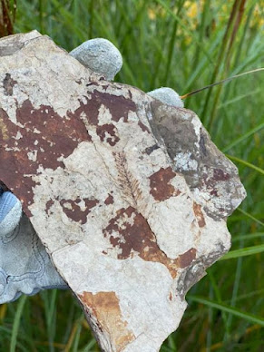
Fossil Metasequoia, McAbee Fossil Beds
Metasequoia fossils are known from many areas in the Northern Hemisphere and were one of my first fossil finds as a teenager. 

And folk love naming them. More than twenty fossil species have been named over time —  some even identified as the genus Sequoia in error — but for all their collective efforts to beef up this genus there are just three species: Metasequoia foxii, Metasequoia milleri, and Metasequoia occidentalis.

During the Paleocene and Eocene, extensive forests of Metasequoia thrived as far north as Strathcona Fiord on Ellesmere Island and sites on Axel Heiberg Island in Canada's far north around 80° N latitude.

We find lovely examples of Metasequoia occidentalis in the Eocene outcrops at McAbee near Cache Creek, British Columbia, Canada. I shared a photo here of one of those specimens. Once this piece dries out a bit, I will take a dental pick to it to reveal some of the teaser fossils peeking out.

The McAbee Fossil Beds are known for their incredible abundance, diversity and quality of fossils including lovely plant, insect and fish species that lived in an old lake bed setting. While the Metasequoia and other fossils found here are 52-53 million years old, the genus is much older. It is quite remarkable that both their fossil and extant lineage were discovered in just a few years of one another. 

Metasequoia was first described as a new genus from a fossil specimen found in 1939 and published by Japanese paleobotanist Shigeru Miki in 1941. Remarkably, the living version of this new genus was discovered later that same year. 

Professor Zhan Wang, an official from the Bureau of Forest Research was recovering from malaria at an old school chum's home in central China. His friend told him of a stand of trees discovered in the winter of 1941 by Chinese botanist Toh Gan (干铎). The trees were not far away from where they were staying and Gan's winter visit meant he did not collect any specimen as the trees had lost their leaves. 

The locals called the trees Shui-sa, or water fir. As trees go, they were reportedly quite impressive with some growing as much as sixty feet tall. Wang was excited by the possibility of finding a new species and asked his friend to describe the trees and their needles in detail. Emboldened by the tale, Wang set off through the remote mountains to search for his mysterious trees and found them deep in the heart of  Modaoxi (磨刀溪; now renamed Moudao (谋道), in Lichuan County, in the central China province of Hubei. He found the trees and was able to collect living specimens but initially thought they were from Glyptostrobus pensilis (水松). 

A few years later, Wang showed the trees to botanist Wan-Chun Cheng and learned that these were not the leaves of s Glyptostrobus pensilis (水松 ) but belonged to a new species. 

While the find was exciting, it was overshadowed by China's ongoing conflict with the Japanese that was continuing to escalate. With war at hand, Wang's research funding and science focus needed to be set aside for another two years as he fled the bombing of Beijing. 

When you live in a world without war on home soil it is easy to forget the realities for those who grew up in it. 

Zhan Wang and his family lived to witness the 1931 invasion of Manchuria, then the 1937 clash between Chinese and Japanese troops at the Marco Polo Bridge, just outside Beijing. 

That clash sparked an all-out war that would grow in ferocity to become World War II. 

Within a year, the Chinese military situation was dire. Most of eastern China lay in Japanese hands: Shanghai, Nanjing, Beijing, Wuhan. As the Japanese advanced, they left a devastated population in their path where atrocity after atrocity was the norm. Many outside observers assumed that China could not hold out, and the most likely scenario was a Japanese victory over China.

Yet the Chinese hung on, and after the horrors of Pearl Harbor, the war became genuinely global. The western Allies and China were now united in their war against Japan, a conflict that would finally end on September 2, 1945, after Allied naval forces blockaded Japan and subjected the island nation to intensive bombing, including the utter devastation that was the Enola Gay's atomic payload over Hiroshima. 

With World War II behind them, the Chinese researchers were able to re-focus their energies on the sciences. Sadly, Wang was not able to join them. Instead, two of his colleagues, Wan Chun Cheng and Hu Hsen Hsu, the director of Fan Memorial Institute of Biology would continue the work. Wan-Chun Cheng sent specimens to Hu Hsen Hsu and upon examination realised they were the living version of the trees Miki had published upon in 1941. 

Hu and Cheng published a paper describing a new living species of Metasequoia in May 1948 in the Bulletin of Fan Memorial Institute of Biology.

That same year, Arnold Arboretum of Harvard University sent an expedition to collect seeds and, soon after, seedling trees were distributed to various universities and arboreta worldwide. 

Today, Metasequoia grow around the globe. When I see them, I think of Wang and all he went through. He survived the conflict and went on to teach other bright, young minds about the bountiful flora in China. I think of Wan Chun Cheng collaborating with Hu Hsen Hsu in a time of war and of Hu keeping up to date on scientific research, even published works from colleagues from countries with whom his country was at war. Deep in my belly, I ache for the huge cost to science, research and all the species impacted on the planet from our human conflicts. Each year in April, I plant more Metasequoia to celebrate Earth Day and all that means for every living thing on this big blue orb.  

References: 

  • https://web.stanford.edu/group/humbioresearch/cgi-bin/wordpress/?p=297
  • https://humboldtredwoods.org/redwoods

Tuesday 12 September 2023

VANCOUVER'S HISTORIC STANLEY PARK

Totem, Welcome & Mortuary Poles at Stanley Park
If you visit Brockton Point in Stanley Park, there are many carved red cedar First Nation poles for you to admire.  

What you are viewing are replicas of First Nation welcome and totem poles that once stood in the park but have been returned to their homes within the province's diverse First Nation communities — or held within museum collections. 

Some of the original totems came from Alert Bay on Cormorant Island, near the Port McNeill on the north coast of Vancouver Island. 

Others came from communities in Haida Gwaii — and still more from the Wuikinuxv First Nations at Rivers Inlet on British Columbia's central west coast — home of the Great Bear Rainforest with her Spirit Bears.

The exception is the most recent addition carved by Robert Yelton in 2009. Robert is a First Nation carver from the Squamish Nation and his original welcome pole graces Brockton Point, the original settlement site of a group of Squamish-Portuguese settlers.  

If you look at the photo above, the lovely chocolate, red and turquoise pole on the right is a replica of the mortuary pole raised to honour the Raven Chief of Skedans or Gida'nsta, the Haida phrase for from his daughter, the title of respect used when addressing a person of high rank. Early fur traders often took the name of the local Chief and used it synonymously as the place names for the sites they visited — hence Skedans from Gida'nsta.

Chief Skedans Mortuary Pole
Chief Skedans, or Qa'gials qe'gawa-i, to his children, lived in Ḵ’uuna Llnagaay, or village at the edge, in Xaayda Kil — a village on the exposed coast of Louise Island — now a Haida Heritage Site.  

There are some paintings you may have seen by Emily Carr of her visits to the site in 1912, She used the phonetic Q'una from Q:o'na to describe both the place name and title of her work. 

Carr's paintings of the totems have always looked to me to be a mash-up — imagine if painter Tamara de Lempicka and photographer Edward Curtis had a baby — not pretty, but interesting.

Some called this area, Huadju-lanas or Xu'adji la'nas, which means Grizzly-Bear-Town, in reference to resident grizzly bear population and their adornment of many totems and artwork by the local artists.

Upon Chief Skedan's death, the mortuary pole was carved both to honour him and provide his final resting place. Dates are a bit fuzzy, but local accounts have this as sometime between 1870-1878 — and at a cost of 290 blankets or roughly $600 in today's currency. 

The great artistry of the pole was much admired by those in the community and those organizing the celebrations for the 1936 Vancouver Golden Jubilee — witnessed by  350,000 newly arrived residents.

Negotiations were pursued and the pole made its way down from Haida Gwaii to Stanley Park in time for the celebrations. The original totem graced Stanley Park for a little over twenty years before eventually making its way back to Haida Gwaii. It was returned to the community with bits of plaster and shoddy paint marring the original. These bits were scraped off and the pole welcomed back with due ceremony. 

In 1964, respected and renowned Northwest Coast master carver, Bill Reid, from the Kaadaas gaah Kiiguwaay, Raven/Wolf Clan of T'anuu, Haida Gwaii and Scottish-German descent, was asked to carve this colourful replica. 

Mountain Goat Detail, Skedans Mortuary Pole
Reid carved the totem onsite in Stanley Park with the help of German carver Werner True. Interestingly, though I looked at length for information on Werner True, all I can find is that he aided Bill Reid on the carving for a payment of $1000.

Don Yeomans, Haida master carver, meticulously recarved the moon crest in 1998. If you have admired the totem pole in the Vancouver Airport, you will have seen some of Yeoman's incredible work. 

The crest is Moon with the face, wings, legs and claws of a mighty and proud Thunderbird with a fairly smallish hooked beak in a split design. We have Moon to thank for the tides and for illuminating our darkest nights. As a crest, Moon is associated with transformation and acts as both guardian and protector.

The original pole had a mortuary box that held the Chief's remains. The crest sits atop a very charming mountain goat. I have included a nice close-up here of the replica for you to enjoy. 

Mountain Goats live in the high peaks of British Columbia and being so close to the sky, they have the supernatural ability to cross over to the sky world. They are also credited as being spirit guardians and guides to First Nation shamans.

I love his horns and tucked-in cloven hooves. There is another pole being carved on Vancouver Island that I hope to see during its creation that also depicts a Mountain Goat. With permission and in time, I hope to share some of those photos with you. 

Mountain Goat is sitting atop Grizzly Bear or Huaji or Xhuwaji’ with little human figures placed in his ears to represent the Chief's daughter and son-in-law, who raised the pole and held a potlatch in his honour. 

Beneath the great bear is Seal or Killer Whale in his grasp. The inscription in the park says it is a Killer Whale but I am not sure about that interpretation — both the look and lore make Seal more likely. Perhaps if Killer Whale were within Thunderbird's grasp — maybe

Though it is always a pleasure to see Killer Whale carved in red cedar, as the first whales came into being when they were carved in wood by a human — or by Raven — then magically infused with the gift of life.

Siwash Rock on the northern end of Third Beach, Stanley Park
The ground these totems sit upon is composed of plutonic, volcanic and sedimentary layers of rock and exhibits the profound influences of glaciation and glacial retreat from the last ice age. 

Glacial deposits sit atop a mix of clay, sand, cobbles and larger boulders of glacial till. 

There are a few areas of exposed volcanics within the park that speak to the scraping of the glaciers as they retreated about 12,500 years ago. 

The iconic moss and lichen-coated Siwash Rock on the northern end of Third Beach is one of the more picturesque of these. It is a basaltic and andesitic volcanic rock — a blend of black phenocrysts of augite cemented together with plagioclase, hornblende and volcanic glass that holds a special place in the oral history of the First Nations of this area. The Squamish First Nation, or Sḵwx̱wú7mesh sníchim, hold the word Slhx̱i7lsh for this rock. 

They tell a story of a man fishing by the shore who was transformed by the spirit-being X̱áays into this iconic rock near the northern end of Third Beach of Stanley Park. At the time, a permanent First Nation settlement was just a short walk away. The man had his fishing gear with him when he was transformed as he had been fishing near the shore. The hole in the rock is not from the erosion of the tides but the cubby hole where Slhx̱i7lsh, now a rocky sentinel, kept his fishing tackle. And as you know, fishing tackle is valuable. One does not simply throw it away simply because you have been turned to stone.

Images not shown: 

Do check out the work of Emily Carr and her paintings of Q:o'na from the 1940s. I'll share a link here but do not have permission to post her works. http://www.emilycarr.org/totems/exhibit/haida/ssintro.htm

Wednesday 6 September 2023

CHUCKANUT TRACKWAYS

Chuckanut Drive is much younger than other parts of Washington. The fossils found there lived and died some 40-55 million years ago, very close to where they are now, but in a much warmer, swampy setting. The exposures of the Chuckanut Formation were once part of a vast river delta. Imagine, if you will, the bayou country of the Lower Mississippi. The siltstones, sandstones, mudstones and conglomerates of the Chuckanut Formation were laid down about 40-54 million years ago during the Eocene epoch, a time of luxuriant plant growth in the subtropical flood plain that covered much of the Pacific Northwest.

This ancient wetland provided ideal conditions to preserve the many trees, shrubs & plants that thrived here. Plants are important in the fossil record because they are more abundant and can give us a lot of information about climate, temperature, the water cycle and humidity of the region. The Chuckanut flora is made up predominantly of plants whose modern relatives live in tropical areas such as Mexico and Central America. If you are interesting in viewing a tropical paradise in your own backyard, look no further than the Chuckanut. Images and tag lines: Glyptostrobus, the Chinese swamp cypress, is perhaps the most common plant found here. Also abundant are fossilized remains of the North American bald cypress, Taxodium; Metasequoia (dawn redwood), Lygodium (climbing fern), large Sabal (palm) and leaves from a variety of broad leaf angiosperm plants such as (witch hazel), Laurus (laurel), Ficus (fig) and Platanus (sycamore), and several other forms.

While less abundant, evidence of the animals that called this ancient swamp home are also found here. Rare bird, reptile, and mammal tracks have been immortalized in the outcrops of the Chuckanut Formation including tracks of Diatryma, a massive flightless bird that reached up to 9 feet in height and made a living in the grasslands and swamps of the Eocene.

Tracks of a type of archaic mammal of the Orders Pantodonta or Dinocerata (blunt foot herbivores), footprints from a small shorebird, and tracks from an early equid or webbed bird track give evidence to the vertebrates that inhabited the swamps, lakes and river ways of the Pacific Northwest 50 million years ago.

Saturday 2 September 2023

UPPER CRETACEOUS HASLAM FORMATION

Steller's Jay, Cyanocitta stelleri
One of the classic Vancouver Island fossil localities is the Santonian-Maastrichtian, Upper Cretaceous Haslam Formation Motocross Pit near Brannen Lake, Nanaimo, British Columbia, Canada.

The quarry is no longer active as such though there is a busy little gravel quarry a little way down the road closer to Ammonite falls near Benson Creek Falls.

Today it is an active motocross site and remains one of the classic localities of the Nanaimo Group. We find well-preserved nautiloids and ammonites — Canadoceras, Pseudoschloenbachia, Epigoniceras — the bivalves — Inoceramus, Sphenoceramus— gastropods, and classic Nanaimo Group decapods — Hoploparia, Linuparus. We also find fossil fruit and seeds which tell the story of the terrestrial history of Vancouver Island.

Upper Cretaceous Haslam Formation Motocross Pit near Brannen Lake
It was John Fam, Vice-Chair, Vancouver Island Paleontological Society (VanPS), who originally told me about the locality. John is one of the most delightful and knowledgeable people you'd be well-blessed to meet.

While he lived on Vancouver Island, he was an active member of the VanPS back when I was Chair. Several of the best joint VIPS/VanPS paleontological expeditions were planned with or instigated by his passion for fossils. I tip my hat to him for his passion and shared love of all things paleo.

John grew up 15 minutes from the motocross locality and used to collect there a few times a week with his father. John has wonderful parents and since marrying his childhood sweetheart, the amazing Grace, those excellent genetics, curiosity and love of fossils are now being passed to a new generation. It's lovely to see John and Grace continuing tradition with two boys of their own.

I met John way back then and did an overnight at his parent's house the Friday before a weekend field trip to Jurassic Point. It was a joy to have him walk me through his collections and tell his stories from earlier years. After learning about the site from John, I headed up to the Motocross Pit with my Uncle Doug. He was a delightful man who grew up on the coast and had explored much of it but not the fossil site just 10-minutes from his home. It was wonderful to walk through time with him so many years ago and then again solo this past year with sadness in my belly that one of the best I've ever known has left this Earth.

Upper Cretaceous Haslam Formation Motocross Pit near Brannen Lake
There were some no trespassing signs up but no people around, so I walked the periphery looking for the bedrock of the Haslam.

The rocks we find here were laid down south of the equator as small, tropical islands. They rode across the Pacific heading north and slightly east over the past 80 million years to where we find them today.

Jim Haggart and Peter Ward have done much to increase our understanding of the molluscan fauna of the Nanaimo Group. Personally, both personify the charming Indiana Jones school of rugged manly palaeontologists you picture in popular film. Professionally, their singular contributions and collaborative efforts have helped shape our understanding of the correlation of Nanaimo Group fauna to those we find in the Gulf Islands of British Columbia and down in the San Juan Islands of Washington State.

Their work builds on the work of Usher (1952), Matsumoto (1959a, 1959b) and Mallory (1977). A healthy nod goes out to the work of Muller and Jeletzky (1970) for untangling the lithostratigraphic and biostratigraphic foundation for our knowledge of the Nanaimo Group.

Candoceras yokoyama, Photo: John Fam, VanPS
As I walked along the bedrock of the Haslam, a Steller's Jay, Cyanocitta stelleri, followed me from tree to tree making his guttural shook, shook, shook call. Instructive, he seemed to be encouraging me, timing his hoots to the beat of my hammer. Vancouver Island truly has glorious flora and fauna.

Fancy some additional reading? Check out a paper published in the Journal of Paleontology back in 1989 by Haggard and Ward on new Nanaimo Group Ammonites from British Columbia and Washington State.

In it, they look at the ammonite species Puzosia (Mesopuzosia) densicostata Matsumoto, Kitchinites (Neopuzosia) japonicus Spath, Anapachydiscus cf. A. nelchinensis Jones, Menuites cf. M. menu (Forbes), Submortoniceras chicoense (Trask), and Baculites cf. B. boulei Collignon are described from Santonian--Campanian strata of western Canada and northwestern United States.

Stratigraphic occurrences and ranges of the species are summarized and those taxa important for correlation with other areas in the north Pacific region and Late Cretaceous ammonite fauna of the Indo-Pacific region. Here's the link: https://www.jstor.org/stable/1305358?seq=1

Peter Ward is a prolific author, both of scientific papers and more popularized works. I highly recommend his book Gorgon: Paleontology, Obsession, and the Greatest Catastrophe in Earth's History. It is an engaging romp through a decade's research in South Africa's Karoo Desert.

Photo: Candoceras yokoyamai from Upper Cretaceous Haslam formation (Lower Campanian) near Nanaimo, British Columbia. One of the earliest fossils collected by John Fam (1993). Prepared using only a cold chisel and hammer. Photo & collection of John Fam, VIPS.

Friday 1 September 2023

ROLLED TRILOBITE: WRENS NEST, UK

A lovely rolled trilobite, Calymene blumenbachii,  from outcrops in the UK. This wee beauty is in the collections of the deeply awesome Theresa Paul Spink Dunn — or perhaps in her daughter Layla's collections as she is quite the budding palaeontologist. This Silurian beauty is from the Homerian, Wenlock Series, Wrens Nest, Dudley, UK.

Calymene blumenbachii, sometimes erroneously spelled blumenbachi, is a species of trilobite found in the limestone quarries of the Wren's Nest in Dudley, England.

Nicknamed the Dudley Bug or Dudley Locust by an 18th-century quarryman, it became a symbol of the town and featured on the Dudley County Borough Council coat-of-arms. Calymene blumenbachii is commonly found in Silurian rocks (422.5-427.5 million years ago) and is thought to have lived in the shallow waters of the Silurian, in low energy reefs.

This particular species of Calymene — a fairly common genus in the Ordovician-Silurian — is unique to the Wenlock series in England and comes from the Wenlock Limestone Formation in Much Wenlock and the Wren's Nest in Dudley. These sites seem to yield trilobites more readily than any other areas on the Wenlock Edge, and the rock here is dark grey as opposed to yellowish or whitish as it appears on other parts of the Edge, just a few miles away, in Church Stretton and elsewhere. This suggests local changes in the environment in which the rock was deposited. The Wenlock Edge quarry is closed now to further collecting but may be open to future research projects. We shall have to see.