Sunday 22 October 2023

LOVE CAN TRAVEL ANYWHERE IN AN INSTANT

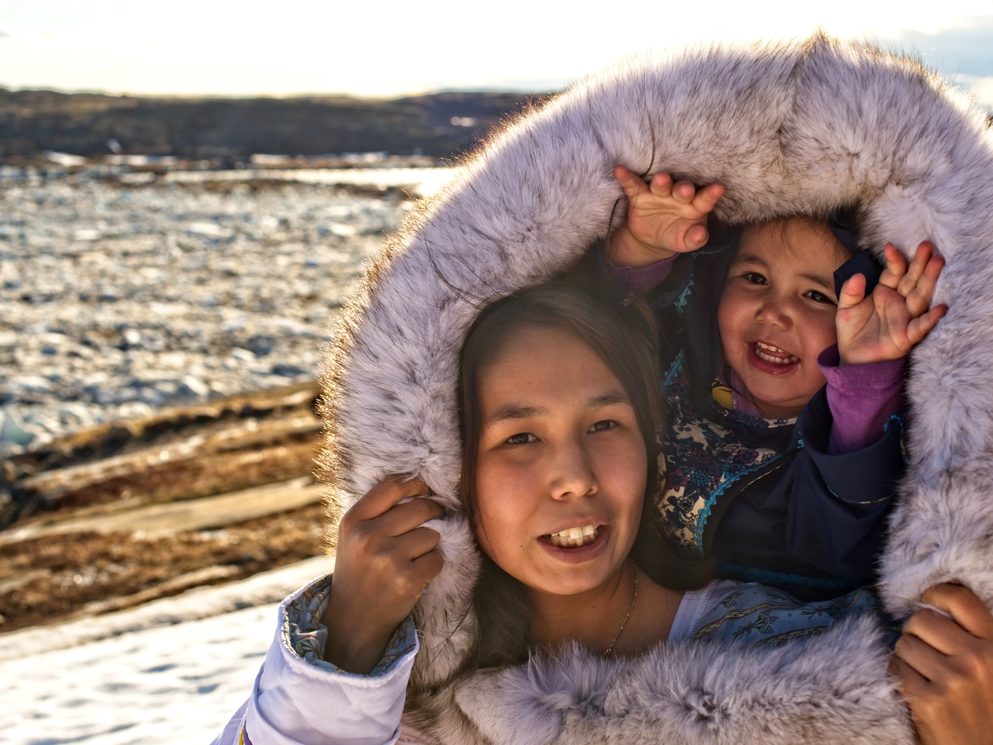
Nunatsiarmiut Mother and Child, Baffin Island, Nunavut
Warm light bathes this lovely Nunatsiarmiut mother and child from Baffin Island, Nunavut. 

They speak Inuktitut, the mother tongue of the majority of the Nunatsiarmiut who call Baffin Island home. 

Baffin is the largest island in the Arctic Archipelago in the territory of Nunavut in Canada's far north—the chilliest region of Turtle Island. 

As part of the Qikiqtaaluk Region of Nunavut, Baffin Island is home to a constellation of remote Inuit communities each with a deep cultural connection to the land—Iqaluit, Pond Inlet, Pangnirtung, Clyde River, Arctic Bay, Kimmirut and Nanisivik. 

The ratio of Inuit to non-Inuit here is roughly three to one and perhaps the reason why the Inuktitut language has remained intact and serves as the mother tongue for more than 36,000 residents. Inuktitut has several subdialects—these, along with a myriad of other languages—are spoken across the north.  

If you look at the helpful visual below you begin to get a feel for the diversity of these many tongues. The languages vary by region. There is the Iñupiaq of the Inupiatun/Inupiat; Inuvialuktun of the Inuinnaqtun, Natsilingmiutut, Kivallirmiutut, Aivilingmiutut, Qikiqtaaluk Uannanganii and Siglitun. Kalaallisut is spoken by many Greenlandic peoples though, in northwest Greenland, Inuktun is the language of the Inughuit.

We use the word Inuktitut when referring to a specific dialect and inuktut when referring to all the dialects of Inuktitut and Inuinnaqtun.

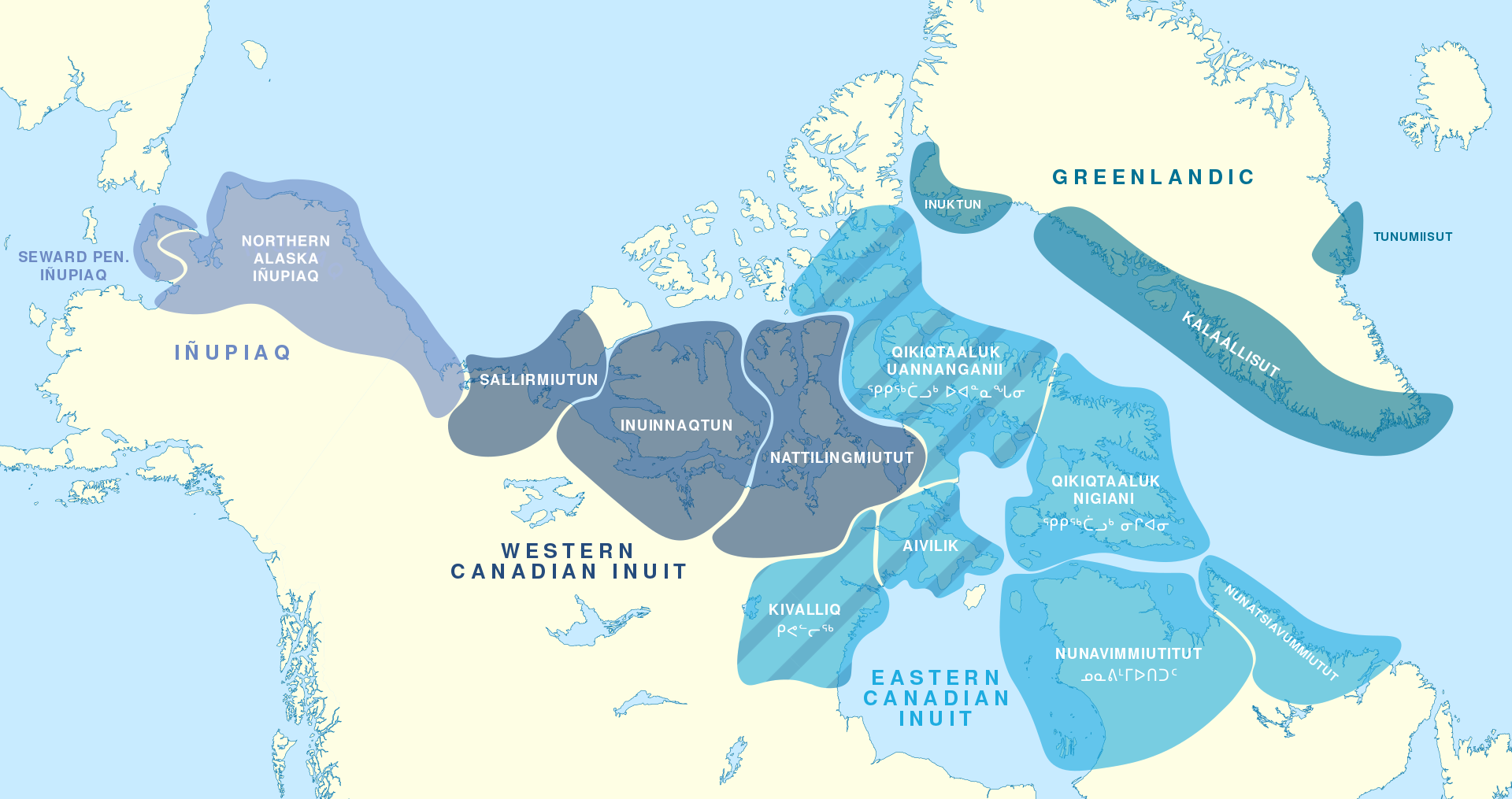
Northern Language Map (Click to Enlarge)
Should you travel to the serene glacier-capped wilds and rolling tundra of our far north, you will want to dress for the weather and learn a few of the basics to put your best mukluk shod feet forward. 

The word for hello or welcome in Inuktitut is Atelihai—pronounced ahh-tee-lee-hi. And thank you is nakurmiik, pronounced na-kur-MIIK.  

Perhaps my favourite Inuktitut expression is Naglingniq qaikautigijunnaqtuq maannakautigi, pronounced NAG-ling-niq QAI-kau-ti-gi-jun-naqtuq MAAN-na-KAU-ti-gi. This tongue-twister is well worth the linguistic challenge as it translates to love can travel anywhere in an instant. Indeed it can. 

So much of our Indigenous culture is passed through stories, so language takes on special meaning in that context. It is true for all societies but especially true for the Inuit. Stories help connect the past to the present and future. They teach how to behave in society, engage with the world and how to survive in the environment. They also help to create a sense of belonging. 

You have likely seen or heard the word Eskimo used in older books to refer to the Inuit, Iñupiat, Kalaallit or Yupik. This misnomer is a colonial term derived from the Montagnais or Innu word ayas̆kimewnetter of snowshoes. It is a bit like meeting a whole new group of people who happen to wear shoes and referring to them all as cobblers—not as a nickname, but as a legal term to describe populations from diverse communities disregarding the way each self-refer. 

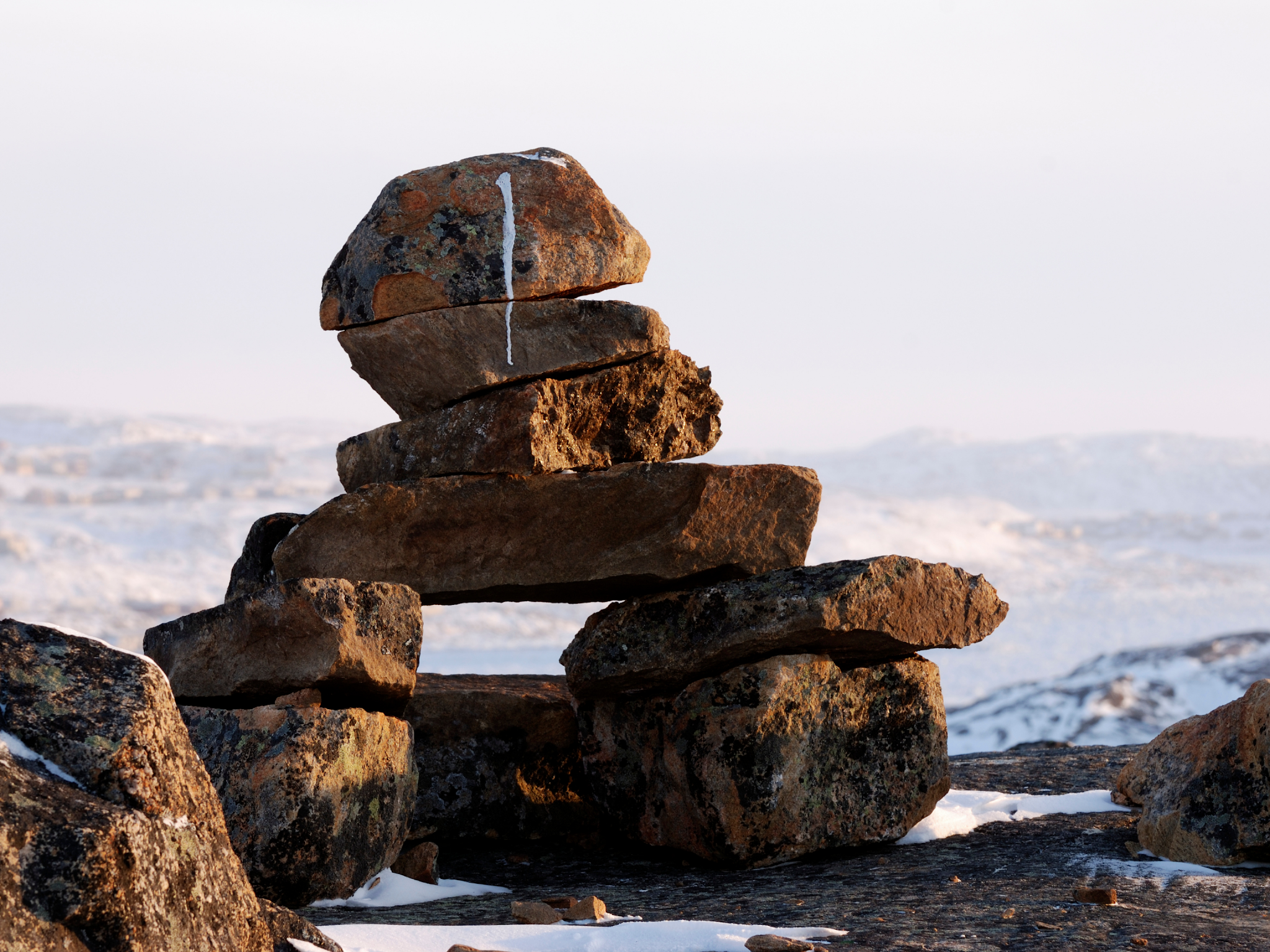
Inukshuk / Inuksuk Marker Cairn
For those who identify as Inupiaq or Yupik, the preferred term is Inuit meaning people—though some lingering use of the term Eskimo lives on. The Inuit as a group are made up of many smaller groups. 

The Inuit of Greenland self-refer as Kalaallit or Greenlanders when speaking Kalaallisut. The Tunumiit of Tunu (east Greenland), speak Tunumiit oraasiat ("East Greenlandic"); and the Inughuit of north Greenland, speak Inuktun "Polar Eskimo."

The Inupiat of Alaska, or real people, use Yupik as the singular for real person and yuk to simply mean person.

When taken all together, Inuit is used to mean all the peoples in reference to the Inuit, Iñupiat, Kalaallit and Yupik. Inuit is the plural of inuk or person

You likely recognize this word from inuksuk or inukshuk, pronounced ih-nook-suuk — the human-shaped stone cairns built by the Inuit, Iñupiat, Kalaallit, Yupik, and other peoples of the Arctic regions of northern Canada, Greenland, and Alaska—as helpful reference markers for hunters and navigation. 

The word inuksuk means that which acts in the capacity of a human, combining inuk or person and suk, as a human substitute

A World of Confusion

You may be disappointed to learn that our northern friends do not live in igloos. I remember answering the phone as a child and the fellow calling was hoping to speak to my parents about some wonderful new invention perfect for use in an igloo. 

The call came while I was in the kitchen of our family home in Port Hardy. He was disappointed to hear that I was standing in a wooden house with the standard four walls to a room and a handy roof topping it off. 

I also had my own room with Scooby-Doo wallpaper, but he was having nothing of it.

"Well, what about your neighbours? Surely, a few of them live in igloos..." 

It seems that some atlases in circulation at the time, and certainly the one he was looking at, simply blanketed everything north of the 49th parallel in a snowy white. His clearly showed an igloo sitting proudly in the centre of the province.

My cousin Shawn brought one such simplified book back from his elementary school in California. British Columbia had a nice image of a grizzly bear and a wee bit further up, a polar bear grinned smugly. 

British Columbia's beaver population would be sad to know that they did not inhabit the province though there were two chipper beavers with big bright smiles—one in Ontario and another gracing the province of Quebec. Further north, where folk do build igloos, their icy domes were curiously lacking. 

Igloos are used for winter hunting trips much the same way we use tents for camping. The Inuit do not have fifty words for snow—you can thank the ethnographer Franz Boas for that wee fabrication—but within the collective languages of the frozen north there are more than fifty words to describe it. And kisses are not nose-to-nose. To give a tender kiss or kunik to a loved one, you press your nose and upper lip to their forehead or cheek and rub gently. 

Fancy trying a wee bit of Inuktitut yourself? This link will bring you to a great place to start: https://inhabitmedia.com/inuitnipingit/

Inuit Language Map:  By Noahedits - Own work, CC BY-SA 4.0. If you want to the image full size, head to this link: https://commons.wikimedia.org/w/index.php?curid=85587388

Friday 20 October 2023

LEMURS OF MADAGASGAR

These lovelies are lemurs. They are very social and like to live in groups of half a dozen to up to 30 individuals. A female leads the group, or troop, and will likely have mated with the stinkiest — think sexiest — male. 

Once they breed, mamma will give birth to one to a half dozen pups after a gestation period of about 100 to 107 days. The wee pups cling to mamma's belly for the first few weeks of life then crawl up to live on her back for the next few months. By three to six months, the wee ones are weaned and a year to three years later, this pup will be mature and ready to mate. If all goes well, some species can live up to 30 years — rather a long life in the wild.

Lemurs are mammals of the order Primates, divided into 8 families and consisting of 15 genera and around 100 highly diverse species — 105 to be exact. They are native only to the island of Madagascar.

Most lemurs are relatively small, have a pointed snout, large eyes, and a long tail. They are arboreal, living primarily in trees and nocturnal, preferring to be active at night, snacking on leaves, shoots, fruit, flowers, tree bark, nectar and sap.

Phylogenetic, genetic, and anatomical evidence all suggest that lemurs split from other primates on Africa around 62 million years ago and that the ancestral lemur lineage had dispersed to Madagascar by around 54 million years ago. They must have come over to the island clinging to floating vegetation.

Once on the island, the lemur lineage diversified. Now there are at least 105 species of lemur, all endemic to Madagascar. They range in size from just an ounce and just 9 to 11 cm in the case of the Madame Berthe's mouse lemurs to up to 15 to 22 lbs or 7 to 10 kilograms, in the case of the Indri.

The evolutionary and biogeographic processes experienced by the lemurs are not unusual. Madagascar is home to many groups of endemic organisms with close within-group relationships. The simplest — or most parsimonious — explanation for this pattern is that, like the lemurs, the groups first arrived on the island by dispersal as a single lineage and then rapidly diversified. This diversification was likely spurred on by other geologic and geographic characteristics of Madagascar.

The east coast of the island is lined with a mountain range — and this causes different parts of the island to get drastically different amounts of rain. Hence, the island is made of many different habitat types — from deserts to rainforests — that have shifted and changed over the past 88 million years. This likely provided many opportunities for subpopulations to become isolated and evolve traits for specializing in different niches. And that likely encouraged lineages to diversify.

Today, Madagascar is one of the most diverse places on Earth. Understanding where that diversity comes from requires understanding, not just the living world, but the geologic, geographic, and climactic histories that have shaped the evolution of lineages on the island. Now, human history in the making threatens to undo tens of millions of years of evolution in just a few years of political turmoil — unless safeguards can be put in place to protect Madagascar's unique biota from the instabilities of human institutions.

Cooper, A., Lalueza-Fox, C., Anderson, S., Rambaut, A., Austin, J., and Ward, R. (2001). Complete mitochondrial genome sequences of two extinct moas clarify ratite evolution. Nature 409:704-707.

Goodman, S. M., and Benstead, J. P. (2005). Updated estimates of biotic diversity and endemism for Madagascar. Oryx 39(1):73-77.

Evolution Berkeley: https://evolution.berkeley.edu/evolibrary/news/091001_madagascar

Vences, M., Wollenberg, K. C., Vieites, D. R., and Lees, D. C. (2009). Madagascar as a model region of species diversification. Trends in Ecology and Evolution 24(8):456-465.

Thursday 19 October 2023

HUNTING NEUTRINOS AND DARK MATTER

Deep inside the largest and deepest gold mine in North America scientists are looking for dark matter particles and neutrinos instead of precious metals. It may not seem exciting on the surface — but it was far below!

The Homestake Gold Mine in Lawrence County, South Dakota was a going concern from about 1876 to 2001.

The mine produced more than forty million troy ounces of gold in its one hundred and twenty-five-year history, dating back to the beginnings of the Black Hills Gold Rush.

To give its humble beginnings a bit of context, Homestake was started in the days of miners hauling loads of ore via horse and mule and the battles of the Great Sioux War. Folk moved about via horse-drawn buggies and Alexander Graham Bell had just made his first successful telephone call.

Wyatt Earp was working in Dodge City, Kansas — he had yet to get the heck outta Dodge — and Mark Twain was in the throes of publishing The Adventures of Tom Sawyer.  — And our dear Thomas Edison had just opened his first industrial research lab in Menlo Park. The mine is part of the Homestake Formation, an Early Proterozoic layer of iron carbonate and iron silicate that produces auriferous greenschist gold. What does all that geeky goodness mean? If you were a gold miner it would be music to your ears. They ground down that schist to get the glorious good stuff and made a tiny wee sum doing so. But then gold prices levelled off — from 1997 ($287.05) to 2001 ($276.50) — and rumblings from the owners started to grow. They bailed in 2001, ironically just before gold prices started up again.

But back to 2001, that levelling saw the owners look to a new source of revenue in an unusual place. One they had explored way back in the 1960s in a purpose-built underground laboratory that sounds more like something out of a science fiction book. The brainchild of chemist and astrophysicists, John Bahcall and Raymond Davis Jr. from the Brookhaven National Laboratory in Upton, New York, the laboratory was used to observe solar neutrinos, electron neutrinos produced by the Sun as a product of nuclear fusion.

Davis had the ingenious idea to use 100,000 gallons of dry-cleaning solvent, tetrachloroethylene, with the notion that neutrinos headed to Earth from the Sun would pass through most matter but on very rare occasions would hit a chlorine-37 atom head-on turning it to argon-37. His experiment was a general success, detecting electron neutrinos,  though his technique failed to sense two-thirds of the number predicted. In particle physics, neutrinos come in three types: electron, muon and tau. Think yellow, green, blue. What Davis had failed to initially predict was the neutrino oscillation en route to Earth that altered one form of neutrino into another. Blue becomes green, yellow becomes blue... He did eventually correct this wee error and was awarded the Nobel Prize in Physics in 2002 for his efforts.

Though Davis’ experiments were working, miners at Homestake continued to dig deep for ore in the belly of the Black Hills of western South Dakota for almost another forty years. As gold prices levelled out and ore quality dropped the idea began to float to re-purpose the mine as a potential site for a new Deep Underground Engineering Laboratory (DUSEL).

A pitch was made and the National Science Foundation awarded the contract to Homestake in 2007.  The mine is now home to the Deep Underground Neutrino Experiment (DUNE) using DUSEL and Large Underground Xenon to look at both neutrinos and dark particle matter. It is a wonderful re-purposing of the site and one that few could ever have predicted. Well done, Homestake. The future of the site is a gracious homage to the now deceased Davis. He would likely be delighted to know that his work continues at Homestake and our exploration of the Universe with it.

Wednesday 18 October 2023

BIOLUMINESCENCE: CHEMICAL POETRY

Light in the oceans? It is chemistry, my friends. 

In the inky blackness of the deep sea, more than 90% of the animals are luminescent. It is quite a startling number but makes good sense when you think of the edge bioluminescence provides. 

The ability to generate light helps umpteen animals find mates, attract prey and avoid predation. Handy stuff, light. 

What you know about light above the surface does not hold true for the light you see as bioluminescence. Its energy and luminosity come from a chemical reaction. 

In a luminescent reaction, two types of chemicals — luciferin and luciferase — combine together. Together, they produce cold light — light that generates less than 20% thermal radiation or heat. 

The light you see is produced by a compound called Luciferin. It is the shiny, showy bit in this chemical show. Luciferase acts as an enzyme, the substance that acts as a catalyst controlling the rate of chemical reactions, allowing the luciferin to release energy as it is oxidized. The colour of the light depends on the chemical structures of the chemicals. There are more than a dozen known chemical luminescent systems, meaning that bioluminescence evolved independently in different groups of organisms.

Coelenterazine is the type of luciferin we find in shrimp, fish and jellyfish. Dinoflagellates and krill share another class of unique luciferins, while ostracods or firefleas and some fish have a completely different luciferin. 

The luciferase found in dinoflagellates is related to the green chemical chlorophyll found in plants. Bioluminescent dinoflagellates are a type of plankton — teensy marine organisms that make the seaways shimmer like the Milky Way as you swim through them. 

Their twinkling lights are brief, each containing about 100 million photons that shine for a tenth of a second. While each individual flicker is here and gone in the wink of an eye, en masse they are awe-inspiring. I have spent many wondrous evenings scuba diving amongst these glittering denizens off our shores. 

Cotylorhiza Tuberculata Jellyfish
In this close up of a Cotylorhiza Tuberculata Jellyfish, you can see the luminosity of her blue and white tentacles. The occurrence of identical luciferins for different types of organisms may suggest a dietary source for some groups strengthening the adage, you are what you eat, or perhaps you glow how you eat

Bacteria and fireflies have unique luminescent chemistries. Fireflies light up when oxygen combines with calcium, adenosine triphosphate (ATP) and luciferin in the presence of luciferase. 

For bacteria, the world stage of luminosity is quite small — and a bit gormless. Just how much light they emit and when is a free-for-all. Not so for the rest of our bioluminescent friends who have very precise control over when they shine and just how bright. 

Bioluminescence comes in a variety of colours, from blue through red. The colour is based on the chemistry, which involves a substrate molecule called luciferin, the source of energy that goes into light, and an enzyme called luciferase or photoprotein. 

Most of this lighting up of our world happens on land or in saltwater. There are almost no bioluminescent organisms native to freshwater.

In terrestrial plants and animals — fireflies, beetles and fungi like this Ghost Fungus, Omphalotus nidiformis, a gilled basidiomycete mushroom — we commonly find green, yellow, and sometimes red. 

In the ocean, bioluminescence is mostly blue-green or green. You would think that blues and green would not show up all that well in our seas but, surprisingly, they do. While sound travels better through saltwater than air, it is the reverse for light. 

Various colours of light do not transmit equally through saltwater. Once we move deeper than the top layer of the ocean warmed by the sun and brimming with nutrients, the epipelagic zone, and move deeper through the mesopelagic, deeper and deeper still to the bathypelagic, frigid abyssalpelagic and finally the deep trenches of the icy pressure and all but inhospitable hadalpelagic, less and less light — until no light — gets through.

It is the twilight of the mesopelagic, 200 - 1000 metres below the surface, that is the sweet spot for most of our bioluminescent friends. Here, only very faint sunlight gets through. The water pressure is higher than at the surface but still lacks the crushing intensity of the lower zones. It is here that bioluminescence becomes a real advantage — good real estate and the showmanship of light pays gold.

We know that the deeper you go in our oceans, less and less sunlight gets through, so if the purpose of bioluminescence is to provide a signal that is noticed by prey, potential mates and predators alike, it is important that the light moves through the seawater, and not be absorbed or scattered — and this plays out in the colours evolved to be seen here. 

If you have spent any time underwater, you will know that blue-green light transmits best through seawater. The deeper you go, the colours fade. Gone are the reds and yellows until everything looks brown or blue-green. Because of this, it is no surprise that blue-green is the most common colouring of bioluminescence in our oceans. 

There are some exceptions to the blue-green/green colour rule — minuscule planktonic polychaete worms, Tomopteris helgolandica, emit yellow light, and deep-sea fish Malacosteus niger in the family Stomiidae, the barbeled dragonfishes, produce both red and blue. 

Malacosteus niger's unique adaptation of producing red bioluminescence is only found in two other deep-sea dwelling creatures, Aristostomias and Pachystomias

This rare form of bioluminescence can reach up to 700 nm in the deep-sea and cannot be perceived by green and blue bioluminescent organisms — granting M. niger a considerable advantage while hunting at depth.

The red light may function as an invisible searchlight of sorts because most animals in the ocean cannot see red light, while the eyes of M. niger are red-sensitive. It is much easier to find and eat something that cannot see you, particularly if it is lit up like a tasty red holiday snack.

Reference: https://latzlab.ucsd.edu/bioluminescence/

Monday 16 October 2023

GINKO: THE MAIDENHAIR TREE

Living and Fossil Ginko biloba
The gorgeous yellow lobed leaf you see here is from a Maidenhair Tree — Ginko. These lovelies grow slowly but are well worth the effort with their delicate and distinctive lobed leaves of green and yellow. 

Ginko are Living Fossils native to China. We find them in the fossil record as far back as the Permian, 270 million years, rising with cycads, seed ferns and early conifers. They were part of the low, open, shrubby canopy covering our world well before the first flowering plants arrived. 

Ginko grew when Weigeltisaurus jaekeli, the oldest gliding vertebrates first soared our ancient skies and the first wee beetles munched on decaying wood on our forest floors. It is the long history of predation by beetles and their friends that have made Ginko what they are today — hardy, stinky and weaponized. 

These trees are truly a wonder. Consider that they have lasted since the Permian, living through multiple extinction events that wiped out millions of species on the planet. They are one of the few living things to survive a recent human-made extinction event — the atomic bomb blast in Hiroshima, Japan on August 6, 1945 — weathering one of the most horrifying moments in human history. 

170 Ginko Survived the Atomic Bombing of Hiroshima
When the bomb dropped on Hiroshima it created a fireball that bloomed 1,200 feet in diameter, vaporizing most everything in its radius. 

Somehow 170 resident Gingko trees withstood the ferocity and heat of that blast — and they are still standing to this day, 76 years later. Seemingly impossible, and yet quite true. It is because of their hardy nature that we began looking closely at their genetic make-up. 

Plants with seeds are either angiosperms, our showy flowering plants, or gymnosperms, the naked seed plants. Ginkgo are gymnosperms but in their own subclass, Ginkgoidae. The ginkgos we see growing today are the last remaining member of that subclass.

We see Ginko's rise and diversify in the Permian. By the Jurassic, they had spread across Laurasia, the lands that would become modern Asia. It is this lucky foothold in a young Asia that would eventually save their species. 

From the Jurassic to the Pleistocene their numbers slowly dwindled. We have some great Eocene fossils from outcrops at Quilchena, Tranquille and the McAbee Fossil Beds that show them doing quite well in the interior of British Columbia some 50 million years ago, but this pocket of lush growth seems the exception and not the norm. 

By the Pleistocene, just 2.5 million years ago, glaciation threatened to kill off the last of the ginkgo lineages. Their last stand and platform for global distribution once again was rooted in the forests of central China. Every Ginko you see today originated from that small foothold in China. 

While beautiful, Ginkgo are stinky. I was out for a late stroll the night before last to try and catch a glimpse of the Aurora Borealis up at Queen Elizabeth Park. As I walked along one of the darkened pathways, my nose caught a whiff of something smelly. Think vomit mixed with decaying leaf matter. I looked up to confirm the culprit, a gorgeous bright yellow Ginko backlit from above. 

Ginko in Dan & Lena Bowen's Garden
The reason for their terrible smell is quite clever. It is the result of the chemicals they produce to ward off insects, fungi and bacteria. 

Ginko boast a massive genome comprising some 10.6 billion DNA letters within each strand. You and I boast only three billion letters in our human genome.

Written within this vast genetic code are 41,840 genes or templates that the tree’s cells use to make complex protein molecules that build and maintain each tree and give these stinky lovelies an enviable anti-insect arsenal. 

The photo at the top shows the yellow lobed leaves of a Ginko biloba against an Eocene partial lobe from the McAbee Fossil Beds up near Cache Creek, British Columbia, Canada. The bright yellow is this tree's Autumn colour palette. The bright green leaves you see in the bottom photo are the summer colour palette of this same species. The photo was taken in the summer in Dan and Lena Bowen's garden during the VIPS Saber-toothed Salmon Barbeque. This year, Dan-the-Man is saving some of those lovely lobed leaves to make up some tea from one of the oldest living species in the world. I am excited to give it a try. 

Saturday 14 October 2023

AN UNLIKELY RHINOCEROS AND THE GREAT DEPRESSION

The Miocene pillow basalts from the Lake Roosevelt National Recreation Area of central Washington hold an unlikely fossil. 

What looks to be a rather unremarkable ballooning at the top of a cave is actually the mould of a small rhinoceros, preserved by sheer chance as its bloated carcass sunk to the bottom of a shallow lake just prior to a volcanic explosion.

We have known about this gem for a long while now. The fossil was discovered by hikers back in 1935 and later cast by the University of California palaeontologists in 1948. 

The Dirty Thirties & The Great Depression

These were the Dirty Thirties and those living in Washington state were experiencing the Great Depression along with the rest of the country and the world. Franklin D. Roosevelt was President of the United States, navigating the States away from laissez-faire economics. 

Charmingly, Roosevelt would have his good name honoured by this same park in April of 1946, a few years before researchers at Berkeley would rekindle interest in the site.

Both hiking and fossil collecting was a fine answer to these hard economic times and came with all the delights of discovery with no cost for natural entertainment. And so it was that two fossil enthusiast couples were out looking for petrified wood just south of Dry Falls on Blue Lake in Washington State. 

While searching the pillow basalt, the Frieles and Peabodys came across a large hole high up in a cave that had the distinctive shape of an upside-down rhinoceros.

This fossil is interesting in all sorts of ways. First, we so rarely see fossils in igneous rocks. As you might suspect, both magma and lava are very hot. Magma, or molten rock, glows a bright red/orange as it simmers at a toasty 700 °C to 1300 °C (or 1300 °F to 2400 °F) beneath the Earth's surface.

A Rhinoceros Frozen in Lava

During the late Miocene and early Pliocene, repeated basaltic lava floods engulfed about 63,000 square miles of the Pacific Northwest over a period of ten to fifteen million years. After these repeated bathings the residual lava accumulated to more than 6,000 feet.

As magma pushes up to the surface becoming lava, it cools to a nice deep black. In the case of our rhino friend, this is how this unlikely fellow became a fossil. Instead of vaporizing his remains, the lava cooled relatively quickly preserving his outline as a trace fossil and remarkably, a few of his teeth, jaw and bones. The lava was eventually buried then waters from the Spokane Floods eroded enough of the overburden to reveal the remains once more.

Diceratherium tridactylum (Marsh, 1875)
Diceratherium (Marsh, 1875) is known from over a hundred paleontological occurrences from eighty-seven collections.

While there are likely many more, we have found fossil remains of Diceratherium, an extinct genus of rhinoceros, in the Miocene of Canada in Saskatchewan, China, France, Portugal, Switzerland, and multiple sites in the United States.

He has also been found in the Oligocene of Canada in Saskatchewan, and twenty-five localities in the United States — in Arizona, Colorado, Florida, Nebraska, North Dakota, Oregon, South Dakota, Washington and Wyoming.  

Diceratherium was a scansorial insectivore with two horns and a fair bit of girth. He was a chunky fellow, weighing in at about one tonne (or 2,200 lbs). That is about the size of a baby Humpback Whale or a walrus.

Back in the Day: Washington State 15 Million-Years Ago

He roamed a much cooler Washington state some 15 million years ago. Ice dams blocked large waterways in the northern half of the state, creating reservoirs. Floodwaters scoured the eastern side of the state, leaving scablands we still see today. In what would become Idaho, volcanic eruptions pushed through the Snake River, the lava cooling instantly as it burst to the surface in a cloud of steam. 

By then, the Cascades had arrived and we had yet to see the volcanic eruptions that would entomb whole forests up near Vantage in the Takama Canyon of Washington state. 

Know Before You Go

You are welcome to go see his final resting site beside the lake but it is difficult to reach and comes with its own risks. Head to the north end of Blue Lake in Washington. Take a boat and search for openings in the cliff face. You will know you are in the right place if you see a white "R" a couple hundred feet up inside the cliff. Inside the cave, look for a cache left by those who've explored here before you. Once you find the cache, look straight up. That hole above you is the outline of the rhino.

If you don't relish the thought of basalt caving, you can visit a cast of the rhino at the Burke Museum in Seattle, Washington. They have a great museum and are pretty sporting as they have built the cast sturdy enough for folk to climb inside. 

The Burke Museum 

The Burke Museum recently underwent a rather massive facelift and has re-opened its doors to the public. You can now explore their collections in the New Burke, a 113,000 sq. ft. building at 4300 15th Ave NE, Seattle, WA 98105, United States. Or visit them virtually, at https://www.burkemuseum.org/

Photo: Robert Bruce Horsfall - https://archive.org/details/ahistorylandmam00scotgoog, Public Domain, https://commons.wikimedia.org/w/index.php?curid=12805514

Reference: Prothero, Donald R. (2005). The Evolution of North American Rhinoceroses. Cambridge University Press. p. 228. ISBN 9780521832403.

Reference: O. C. Marsh. 1875. Notice of new Tertiary mammals, IV. American Journal of Science 9(51):239-250

Lincoln, Roosevelt and Recovery from The Great Depression

Rural Tennessee has electricity for the same reason Southeast Alaska has totem parks. In order to help the nation recover from The Great Depression, President Franklin D. Roosevelt, created a number of federal agencies to put people to work. From 1938-1942 more than 200 Tlingit and Haida men carved totem poles and cleared land for the Civilian Conservation Corps in an effort to create “totem parks” the federal government hoped would draw travelers to Alaska.

This odd intersection of federal relief, Alaska Native art and marketing is the subject of Emily L. Moore’s book “Proud Raven, Panting Wolf: Carving Alaska’s New Deal Totem Parks.”

This effort to bring poles out of abandoned villages includes the Lincoln Pole being moved to Saxman Totem Park by the Civilian Conservation Corps (CCC), who established the Saxman Totem Park in 1938.  

The top carving on the Lincoln Pole bears a great likeness of Abraham Lincoln. According to the teachings of many Tlingit elders, this carving was meant to represent the first white man seen in Tlingit territory in the 18th century.  

A century later, in the 1880s, one of my ancestors from the Gaanax.ádi Raven clan of the Tongass Tlingit commissioned the pole to commemorate our ancestor's pride to have seen this first white man—which has become a Gaanax.ádi crest—using a photograph of Abraham Lincoln as the model. 

It is important not only for these various readings of the crests but also because it claims Gaanax.ádi clan territory before the first Europeans and budding Americans came to these shores—territory that Tlingit carvers who were re-carving the pole in the 1940s were trying to assert to the U.S. government as sovereign land.

Interestingly, another pole in that same park is the Dogfish Pole, carved for Chief Ebbits Andáa, Teikweidi, Valley House. The Chief Ebbits Memorial Pole—the Dogfish Kootéeyaa Pole—was raised in 1892 in Old Tongass Village in honour of a great man, Head Chief of the Tongass and my ancestor. It was then moved, re-carved and re-painted at Saxman Totem Park in 1938 as part of Roosevelt's program—and it due to be re-carved again this year. 

It tells the story of his life and the curious way he became Ebbits as he was born Neokoots. He met and traded with some early American fur traders. One of those traders was a Mister Ebbits. The two became friends and sealed that friendship with the exchanging of names.  

If you would like to read more about that pole and others, I recommend, The Wolf and the Raven, by anthropologist Viola Garfield and architect Linn Forrest (my talented cousin), published in 1961 and still in print as I ordered a copy for a friend just this year.

Thursday 12 October 2023

FOSSIL FISHAPODS OF CANADA'S FAR NORTH

Qikiqtania wakei, a fishapod & relative to tetrapods
You will likely recall the amazing tetrapodomorpha fossil found on Ellesmere Island in the Canadian Arctic in 2004, Tiktaalik roseae

These were advanced forms transitional between fish and the early labyrinthodonts playfully referred to as fishapods — half-fish, half-tetrapod in appearance and limb morphology. 

Up to that point, the relationship of limbed vertebrates (tetrapods) to lobe-finned fish (sarcopterygians) was well known, but the origin of significant tetrapod features remained obscure for the lack of fossils that document the sequence of evolutionary changes — until Tiktaalik

While Tiktaalik is technically a fish, this fellow is as far from fish-like as you can be and still be a card-carrying member of the group. 

Interestingly, while Neil Shubin and crew were combing the icy tundra for Tiktaalik, another group was trying their luck just a few kilometres away. 

A week before the eureka moment of Tiktaalik's discovery, Tom Stewart and Justin Lemberg unearthed material that we now know to be a relative of Tiktaalik's. 

Meet Qikiqtania wakei, a fishapod and close relative to our dear tetrapods — and cousin to Tiktaalik — who shares features in the flattened triangular skull, shoulders and elbows in the fin. 

Qikiqtania (pronounced kick-kick-TAN-ee-ya)
But, and here’s the amazing part, its upper arm bone (humerus) is specialised for open water swimming, not walking. 

The story gets wilder when we look at Qikiqtania’s position on the evolutionary tree— all the features for this type of swimming are newly evolved, not primitive. 

This means that Qikiqtania secondarily reentered open water habitats from ancestors that had already had some aspect of walking behaviour. 

And, this whole story was playing out 365 million years ago — the transition from water to land was going both ways in the Devonian.

Why is this exciting? You and I descend from those early tetrapods. We share the legacy of their water-to-land transition and the wee bony bits in their wrists and paddles that evolved to become our hands. I know, mindblowing!

Thomas Stewart and Justin Lemberg put in thousands of hours bringing Qikiqtania to life. 

The analysis consisted of a long path of wild events— from a haphazard moment when it was first spotted, a random collection of a block that ended up containing an articulated fin, to a serendipitous discovery three days before Covid lockdowns in March 2020.

Both teams acknowledge the profound debt owed to the individuals, organizations and indigenous communities where they had the privilege to work — Grise Fiord and Resolute Bay— Ellesmere Island in Nunavut, the largest and northernmost territory of Canada. 

Part of that debt is honoured in the name chosen for this new miraculous species. 

Aerial View of Ellesmere Island
The generic name, Qikiqtania (pronounced kick-kick-TAN-ee-ya), is derived from the Inuktitut words Qikiqtaaluk and Qikiqtani which are the traditional place name of the region where the fossil was discovered. 

The specific name, wakei, is in memory of the evolutionary biologist David Wake — colleague, mentor and friend. 

He was a professor of integrative biology and Director and curator of herpetology at the Museum of Vertebrate Zoology at the University of California, Berkeley who passed away in April 2021. 

Wake is known for his work on the biology and evolution of salamanders and vertebrate evolutionary biology. 

If you look at the photo on the left you can imagine visiting these fossil localities in Canada's far north.

Qikiqtania was found on Inuit land and belongs to the community. Thomas Stewart and his colleagues were able to conduct this research because of the generosity and support of individuals in the hamlets of Resolute Bay and Grise Fiord, the Iviq Hunters and Trappers of Grise Fiord, and the Department of Heritage and Culture, Nunavut.

To them, on behalf of the larger scientific community — Nakurmiik. Thank you! 

Here is the link to Tom Stewart's article in The Conversation & paper in Nature that dropped yesterday:

  1. Stewart, Thomas A.; Lemberg, Justin B.; Daly, Ailis; Daeschler, Edward B.; Shubin, Neil H. (2022-07-20). "A new elpistostegalian from the Late Devonian of the Canadian Arctic". Naturedoi:10.1038/s41586-022-04990-wISSN 0028-0836.
  2. Stewart, Thomas. "Meet Qikiqtania, a fossil fish with the good sense to stay in the water while others ventured onto land" The Conversation. Retrieved 2022-07-20.

Image One: An artist’s vision of Qikiqtania enjoying its fully aquatic, free-swimming lifestyle. Alex Boersma, CC BY-ND

Image Two: A new elpistostegalian from the Late Devonian of the Canadian Arctic, T. A. Stewart, J. B. Lemberg, A. Daly, E. B. Daeschler, & N. H. Shubin.

A huge shout out to the deeply awesome Neil Shubin who shared that the paper had been published and offered his insights on what played out behind the scenes!

Sunday 8 October 2023

FOSSILS OF TURTLE ISLAND'S EAST KOOTENAY REGION

Tanglefoot Mountain. Photo: Dan Bowden
The East Kootenay region on the south-eastern edge of British Columbia is a land of colossal mountains against a clear blue sky. 

That is not strictly true, of course, as this area does see its fair share of rain and temperature extremes — but visiting in the summer every view is a postcard of mountainous terrain.

Rocks from deep within the Earth's crust underlie the entire East Kootenay region and are commonly exposed in the area's majestic mountain peaks, craggy rocky cliffs, glaciated river canyons, and rock cuts along the highways. Younger Ice Age sediments blanket much of the underlying rock.

I have been heading to the Cranbrook and Fernie area since the early 1990s. My interest is the local geology and fossil history that these rocks have to tell. I am also drawn to the warm and welcoming locals who share a love for the land and palaeontological treasures that open a window to our ancient past.  

Cranbrook is the largest community in the region and is steeped in mining history and the opening of the west by the railway. It is also a stone's throw away from Fort Steele and the Lower Cambrian exposures of the Eager Formation. These fossil beds rival the slightly younger Burgess Shale fauna and while less varied, produce wonderful examples of olenellid trilobites and weird and wonderful arthropods nearly half a billion years old. 

Labiostria westriopi, McKay Group
The Lower Cambrian Eager Formation outcrops at a few localities close to Fort Steele, many known since the early 1920s, and up near Mount Grainger near the highway. 

Further east, the Upper Cambrian McKay Group near Tanglefoot Mountain is a palaeontological delight with fifteen known outcrops that have produced some of the best-preserved and varied trilobites in the province — many of them new species. 

The McKay Formation also includes Ordovician outcrops sprinkled in for good measure.

Other cities in the area and the routes to and from them produce other fossil fauna from Kimberley to Fernie and the district municipality of Invermere and Sparwood. This is an arid country with native grasslands and forests of semi-open fir and pine. Throughout there are a host of fossiliferous exposures from Lower Cretaceous plants to brachiopods. 

The area around Whiteswan Lake has wonderful large and showy Ordovician graptolites including Cardiograptus morsus and Pseudoclimacograptus angustifolius elongates — some of our oldest relatives. A drive down to Flathead will bring you to ammonite outcrops and you can even find Eocene fresh-water snails in the region. 

The drive from Cranbrook to Fernie is about an hour and change through the Cambrian into the Devonian which flip-flops and folds over revealing Jurassic exposures. On my last visit, I made the trip with local geologist Guy Santucci who swings around the hairpin bends with panache. He is a delight to travel with and interspersed great conversation with tasty bits of information on the local geology.

Fernie Ichthyosaur Excavation, 1916
The Crowsnest Highway into Fernie follows Mutz Creek. From the highway, you can see the Fernie Group and the site along the Elk River where an ichthyosaur was excavated in 1916. 

The Fernie Formation is Jurassic. It is present in the western part of the Western Canada Sedimentary Basin in western Alberta and northeastern British Columbia. 

It takes its name from the town of Fernie, British Columbia, and was first defined by W.W. Leach in 1914. The town of Fernie is rimmed by rugged mountains tipped with Devonian marine outcrops. In essence, all these mountains are upside down with the oldest layers flipped to the top and a good 180 million years older than those they sit upon. 

Before they were mountains, these sedimentary rocks were formed as sediment collected in a shallow sea or inland basin. About 360 million years ago, the rocks that you see in Fernie today were down near the equator. They road tectonic plates, pushing northeast smashing into the coastline of what would become British Columbia. A little push here, shove there — compression and thrust faulting — and the rock was rolled over on its head — repeatedly. But that is how mountains are often formed, though not usually pushed so hard that they flip over. But still, it is a slow, relentless business. 

Cretaceous Plant Material, Fernie, BC
Within Fernie, there are small exposures of Triassic and Jurassic marine outcrops. East of the town there are Cretaceous plant sites, and of course, the Jurassic 1.4-metre Titanites occidentalis ammonite up on Coal Mountain.

Once up at the fossil exposures we begin to look for treasures. Over the next four or five hours, as the heat of the day sets in, we find block after block of dark brown to beige Cretaceous material embedded with coal seams and lithified fossil remains.

The regional district's dominant landform is the Rocky Mountain Trench, which is flanked by the Purcell Mountains and the Rocky Mountains on the east and west, and includes the Columbia Valley region. The southern half of which is in the regional district — its northern half is in the Columbia-Shuswap Regional District. 

The regional district of Elk Valley in the southern Rockies is the entryway to the Crowsnest Pass and an important coal-mining area. 

Other than the Columbia and Kootenay Rivers, whose valleys shape the bottomlands of the Rocky Mountain Trench, the regional districts form the northernmost parts of the basins of the Flathead, Moyie and Yahk Rivers. 

The Moyie and Yahk are tributaries of the Kootenay, entering it in the United States, and the Flathead is a tributary of the Clark Fork into Montana.

Photo One: Tyaughton Mountain, Mckay Group taken by Dan Bowden via drone; Photo Two: Labiostria westriopi, Upper Cambrian McKay Group, Site ML (1998); John Fam Collection; Photo Three: Ichthyosaur Excavation, Fernie, British Columbia, 1916; Photo Four: Cretaceous Plant Fossils, east of Fernie towards Coal Mountain. The deeply awesome Guy Santucci as hand-model for scale. 

Saturday 7 October 2023

QUINTUS SERTORIOUS AND THE MYTH OF THE GIANT OGRE

Tetralophodon
During the Miocene and Pliocene, 12-1.6 million years ago, a diverse group of extinct proboscideans, elephant-like animals walked the Earth.

Most of these large beasts had four tusks and likely a trunk similar to modern elephants. They were creatures of legend, inspiring myths and stories of fanciful creatures to the first humans to encounter them.

Beyond our Neanderthal friends, one such fellow was Quintus Sertorius, a Roman statesman come general, who grew up in Umbria. Born into a world at war just two years before the Romans sacked Corinth to bring Greece under Roman rule, Quintus lived much of his life as a military man far from his native Norcia. Around 81 BC, he travelled to Morocco, the land of opium, massive trilobites and the birthplace of Antaeus, the legendary North African ogre who was killed by the Greek hero Heracles.

The locals tell a tale that Quintus requested proof of Antaeus, hard evidence he could bring back to Rome to support their tales so they took him to a mound near Tingis, the ancient name for Tangier, Morocco. It was here they unearthed the bones of an extinct elephantoid, Tetralophodon.

Tetralophodon bones are large and skeletons singularly impressive. Impressive enough to be taken for something else entirely. By all accounts, these proboscidean remains were that of the mythical giant, Antaeus, son of the gods Poseidon and Gaea and were thus reported back to Rome as such. Antaeus went on to marry the goddess Tinge and it is from her, in part, that Tangier in northwestern Morocco gets its name. Together, Antaeus and Tinge had a son, Sophax. He is credited with having the North Africa city take her name. Rome was satisfied with the find. It would be hundreds of years later before the bones true ancestry was known and in that time, many more wonderful ancient proboscideans remains were unearthed..

There were other early proboscideans, of course. The earliest known proboscidean is Eritherium, followed by Phosphatherium, a small animal about the size of a fox. Both date from late Paleocene deposits of Morocco.

Proboscideans evolved in Africa, where they increased in size and diversity during the Eocene and early Oligocene. Several primitive families from these epochs have been described, including the Numidotheriidae, Moeritheriidae, and Barytheriidae, all found exclusively in Africa. 

The Anthracobunidae from the Indian subcontinent were also believed to be a family of proboscideans, but were excluded from the Proboscidea by Shoshani and Tassy (2005) and have more recently been assigned to the Perissodactyla.

When Africa became connected to Europe and Asia after the shrinking of the Tethys Sea, proboscideans migrated into Eurasia, with some families eventually reaching the Americas. Proboscideans found in Eurasia as well as Africa include the Deinotheriidae, which thrived during the Miocene and into the early Quaternary, Stegolophodon, an early genus of the disputed family Stegodontidae; the highly diverse Gomphotheriidae and Amebelodontidae; and the much loved Mammutidae, or mastodons.

I traveled and hiked through much of Morocco to explore the countryside, ancient Roman ruins and many splendid outcrops when I was eighteen. I wish I had known more of the fossil sites before that trip but many had yet to be discovered. I will share more of those stories — and there are plenty — in future posts.

Photo: Henan Geological Museum, Zhengzhou, China. Complete indexed photo collection at WorldHistoryPics.com.

Thursday 5 October 2023

FOSSILS AND FIRST NATIONS OF EASTERN CANADA

Elpistostege watsoni

In the late 1930s, our understanding of the transition of fish to tetrapods — and the eventual jump to modern vertebrates — took an unexpected leap forward. The evolutionary a'ha came from a single partial fossil skull found on the shores of a riverbank in Eastern Canada. 

Meet the Stegocephalian, Elpistostege watsoni, an extinct genus of finned tetrapodomorphs that lived during the Late Givetian to Early Frasnian of the Late Devonian — 382 million years ago. 

Elpistostege watsoni — perhaps the sister taxon of all other tetrapods — was first described in 1938 by British palaeontologist and elected Fellow of the Royal Society of London, Thomas Stanley Westoll. Westoll's research interests were wide-ranging. He was a vertebrate palaeontologist and geologist best known for his innovative work on Palaeozoic fishes and their relationships with tetrapods. 

As a specialist in early fish, Westoll was asked to interpret that single partial skull roof discovered at the Escuminac Formation in Quebec, Canada. His findings and subsequent publication named Elpistostege watsoni and helped us to better understand the evolution of fishes to tetrapods — four-limbed vertebrates — one of the most important transformations in vertebrate evolution. 

Hypotheses of tetrapod origins rely heavily on the anatomy of but a few tetrapod-like fish fossils from the Middle and Late Devonian, 393–359 million years ago. These taxa — known as elpistostegalians — include Panderichthys, Elpistostege and Tiktaalik — none of which had yet to reveal the complete skeletal anatomy of the pectoral fin. 

Elpistostege watsoni
None until 2010 that is, when a complete 1.57-metre-long articulated specimen was found and described by Richard Cloutier et al. in 2020. 

The specimen helped us to understand the origin of the vertebrate hand. Stripped from its encasing stone, it revealed a set of paired fins of Elpistostege containing bones homologous to the phalanges (finger bones) of modern tetrapods and is the most basal tetrapodomorph known to possess them. 

Once the phalanges were uncovered, prep work began on the fins. The fins were covered in wee scales and lepidotrichia (fin rays). The work was tiresome, taking more than 2,700 hours of preparation but the results were thrilling. 

Origin of the Vertebrate Hand
We could now clearly see that the skeleton of the pectoral fin has four proximodistal rows of radials — two of which include branched carpals — as well as two distal rows organized as digits and putative digits. 

Despite this skeletal pattern — which represents the most tetrapod-like arrangement of bones found in a pectoral fin to date blurring the line between fish and land vertebrates — the fin retained lepidotrichia (those wee fin rays) distal to the radials. 

This arrangement confirmed an age-old question — showing us for the first time that the origin of phalanges preceded the loss of fin rays, not the other way around.

E. watsoni is very closely related to Tiktaalik roseae found in 2004 in the Canadian Arctic — a tetrapodomorpha species also known as a Choanata. These were advanced forms transitional between fish and the early labyrinthodonts playfully referred to as fishapods — half-fish, half-tetrapod in appearance and limb morphology. 

Up to that point, the relationship of limbed vertebrates (tetrapods) to lobe-finned fish (sarcopterygians) was well known, but the origin of major tetrapod features remained obscure for lack of fossils that document the sequence of evolutionary changes — until Tiktaalik. While Tiktaalik is technically a fish, this fellow is as far from fish-like you can be and still be a card-carrying member of the group. 

Tiktaalik roseae
Complete with scales and gills, this proto-fish lacked the conical head we see in modern fish but had a rather flattened triangular head more like that of a crocodile. 

Tiktaalik had scales on its back and fins with fin webbing but like early land-living animals, it had a distinctive flat head and neck. He was a brawny brute. The shape of his skull and shoulder look part fish and part amphibian.

The watershed moment came as Tiktaalik was prepped. Inside Tiktaalik's fins, we find bones that correspond to the upper arm, forearm and even parts of the wrist — all inside a fin with webbing — remarkable! 

Its fins have thin ray bones for paddling like most fish, but with brawny interior bones that gave Tiktaalik the ability to prop itself up, using his limbs for support. I picture him propped up on one paddle saying, "how you doing?" 

Six years after Tiktaalik was discovered by Neil Shubin and team in the ice-covered tundra of the Canadian Arctic on southern Ellesmere Island, a team working the outcrops at Miguasha on the Gaspé Peninsula discovered the only fully specimen of E. watsoni found to date — greatly increasing our knowledge of this finned tantalizingly transitional tetrapodomorph. 

E. watsoni fossils are rare — this was the fourth specimen collected in over 130 years of hunting. Charmingly, the specimen was right on our doorstop — extracted but a few feet away from the main stairs descending onto the beach of Miguasha National Park. 

L'nu Mi’gmaq First Nations of the Gespe’gewa’gi Region

Miguasha is nestled in the Gaspésie or Gespe’gewa’gi region of Canada — home to the Mi’gmaq First Nations who self-refer as L’nu or Lnu. The word Mi’gmaq or Mi’kmaq means the family or my allies/friends in Mi'kmaw, their native tongue (and soon to be Nova Scotia's provincial first language). They are the people of the sea and the original inhabitants of Atlantic Canada having lived here for more than 10,000 years. 

The L'nu were the first First Nation people to establish contact and trade with European explorers in the 16th and 17th centuries — and perhaps the Norse as early as the turn of the Millenium. Sailing vessels filled with French, British, Scottish, Irish and others arrived one by one to lay claim to the region — settling and fighting over the land. As each group rolled out their machinations of discovery, tensions turned to an all-out war with the British and French going head to head. I'll spare you the sordid details but for everyone caught in the crossfire, it went poorly.

North America Map 1775 (Click to Enlarge)
Cut to 1760, the British tipped the balance with their win at the Battle of the Restigouche, the last naval battle between France and England for possession of the North American continent — Turtle Island. 

The bittersweet British victory sparked the American War of Independence. 

For the next twenty years, the L'nu would witness and become embroiled in yet another war for these lands, their lands — first as bystanders, then as American allies, then intimidated into submission by the British Royal Navy with a show of force by way of a thirty-four gun man-of-war, encouraging L'nu compliance — finally culminating in an end to the hostilities with the 1783 Treaty of Paris. 

The peace accord held no provisions for the L'nu, Métis and First Nations impacted. None of these newcomers was Mi'kmaq — neither friends nor allies.

It was to this area some sixty years later that the newly formed Geological Survey of Canada (GSC) began exploring and mapping the newly formed United Province of Canada. Geologists in the New Brunswick Geology Branch traipsed through the rugged countryside that would become a Canadian province in 1867. 

It was on one of these expeditions that the Miguasha fossil outcrops were discovered. They, too, would transform in time to become Miguasha National Park or Parc de Miguasha, but at first, they were simply the promising sedimentary exposures on the hillside across the water —  a treasure trove of  Late Devonian fauna waiting to be discovered.

In the summer of 1842, Abraham Gesner, New Brunswick’s first Provincial Geologist, crossed the northern part of the region exploring for coal. Well, mostly looking for coal. Gesner also had a keen eye for fossils and his trip to the Gaspé Peninsula came fast on the heels of a jaunt along the rocky beaches of Chignecto Bay at the head of the Bay of Fundy and home to the standing fossil trees of the Joggins Fossil Cliffs. 

Passionate about geology and chemistry, he is perhaps most famous for his invention of the process to distil the combustible hydrocarbon kerosene from coal oil — a subject on which his long walks exploring a budding Canada gave him a great deal of time to consider. We have Gesner to thank for the modern petroleum industry. He filed many patents for clever ways to distil the soft tar-like coal or bitumen still in use today.

He was skilled in a broad range of scientific disciplines — being a geologist, palaeontologist, physician, chemist, anatomist and naturalist — a brass tacks geek to his core. Gesner explored the coal exposures and fossil outcrops across the famed area that witnessed the region become part of England and not France — and no longer L'nu.

Following the Restigouche River in New Brunswick through the Dalhousie region, Gesner navigated through the estuary to reach the southern coast of the Gaspé Peninsula into what would become the southeastern coast of Quebec to get a better look at the cliffs across the water. He was the first geologist to lay eyes on the Escuminac Formation and its fossils.

In his 1843 report to the Geologic Survey, he wrote, “...I found the shore lined with a coarse conglomerate. Farther eastward the rocks are light blue sandstones and shales, containing the remains of vegetables. (...) In these sandstone and shales, I found the remains of fish and a small species of tortoise with fossil foot-marks.”

We now know that this little tortoise was the famous Bothriolepis, an antiarch placoderm fish. It was also the first formal mention of the Miguasha fauna in our scientific literature. Despite the circulation of his report, Gesner’s discovery was all but ignored — the cliffs and their fossil bounty abandoned for decades to come. Geologists like Ells, Foord and Weston, and the research of Whiteaves and Dawson, would eventually follow in Gesner's footsteps.

North America Map 1866 (Click to Enlarge)
Over the past 180 years, this Devonian site has yielded a wonderfully diverse aquatic assemblage from the Age of Fishes — five of the six fossil fish groups associated with the Devonian including exceptionally well-preserved fossil specimens of the lobe-finned fishes. 

This is exciting as it is the lobe-finned fishes — the sarcopterygians — that gave rise to the first four-legged, air-breathing terrestrial vertebrates – the tetrapods. 

Fossil specimens from Miguasha include twenty species of lower vertebrates — anaspids, osteostra-cans, placoderms, acanthodians, actinopterygians and sarcopterygians — plus a limited invertebrate assemblage, along with terrestrial plants, scorpions and millipedes.

Originally interpreted as a freshwater lacustrine environment, recent paleontological, taphonomic, sedimentological and geochemical evidence corroborates a brackish estuarine setting — and definitely not the deep waters of the sea. This is important because the species that gave rise to our land-living animals began life in shallow streams and lakes. It tells us a bit about how our dear Elpistostege watsoni liked to live — preferring to lollygag in cool river waters where seawater mixed with fresh. Not fully freshwater, but a wee bit of salinity to add flavour.  

  • Photos: Elpistostege watsoni (Westoll, 1938 ), Upper Devonian (Frasnian), Escuminac formation, Parc de Miguasha, Baie des Chaleurs, Gaspé, Québec, Canada. John Fam, VanPS
  • Origin of the Vertebrate Hand Illustration, https://www.nature.com/articles/s41586-020-2100-8
  • Tiktaalik Illustration: By Obsidian Soul - Own work, CC BY 4.0, https://commons.wikimedia.org/w/index.php?curid=47401797

References & further reading:

  • From Water to Land: https://www.miguasha.ca/mig-en/the_first_discoveries.php
  • UNESCO Miguasha National Park: https://whc.unesco.org/en/list/686/
  • Office of L'nu Affairs: https://novascotia.ca/abor/aboriginal-people/
  • Cloutier, R., Clement, A.M., Lee, M.S.Y. et al. Elpistostege and the origin of the vertebrate hand. Nature 579, 549–554 (2020). https://doi.org/10.1038/s41586-020-2100-8
  • Daeschler, E. B., Shubin, N. H. & Jenkins, F. A. Jr. A Devonian tetrapod-like fish and the evolution of the tetrapod body plan. Nature 440, 757–763 (2006).
  • Shubin, Neil. Your Inner Fish: A Journey into the 3.5 Billion History of the Human Body.
  • Evidence for European presence in the Americas in AD 1021: https://www.nature.com/articles/s41586-021-03972-8

Sunday 1 October 2023

FOSSIL BIRDS OF SOOKE ON VANCOUVER ISLAND'S SOUTHERN SHORES

Stemec suntokum, Sooke Formation
The diving bird you see here is Stemec suntokum, a Fossil Plopterid from Sooke, British Columbia, Canada.

We all dream of finding new species, and new fossil species in particular. This happens more than you think. As impossible as it sounds, it has happened numerous times at many fossils sites in British Columbia including Sooke on Vancouver Island.

The upper Oligocene Sooke Formation outcrops at Muir Beach on southwestern Vancouver Island, British Columbia where it is flanked by the cool, clear waters of the Strait of Juan de Fuca.

While the site has been known since the 1890s, my first trip here was in the early 1990s as part of a Vancouver Paleontological Society (VanPS) fossil field trip. This easy, beach walk locality is a wonderful place to collect fossils and is especially good for families. If you are solar-powered, you will enjoy the sun playing off the surf from May through September. If you are built of hardier stuff, then the drizzle of Spring or Autumn is a lovely, un-people-y time to walk the beachfront.

As well as amazing west coast scenery, the beach site outcrop has a lovely soft matrix with well-preserved fossil molluscs, often with the shell material preserved (Clark and Arnold, 1923).

By the Oligocene ocean temperatures had cooled to near modern levels and the taxa preserved here as fossils bear a strong resemblance to those found living beneath the Strait of Juan de Fuca today. Gastropods, bivalves, echinoids, coral, chitin and limpets are common-ish — and on rare occasions, fossil marine mammals, cetacean and bird bones are discovered.

Fossil Bird Bones 

Back in 2013, Steve Suntok and his family found fossilized bones from a 25-million-year-old wing-propelled flightless diving bird while out strolling the shoreline near Sooke. Not knowing what they had found but recognizing it as significant, the bones were brought to the Royal British Columbia Museum to identify.

The bones found their way into the hands of Gary Kaiser. Kaiser worked as a biologist for Environment Canada and the Nature Conservatory of Canada. After retirement, he turned his eye from our extant avian friends to their fossil lineage. The thing about passion is it never retires. Gary is now a research associate with the Royal British Columbia Museum, published author and continues his research on birds and their paleontological past.

Kaiser identified the well-preserved coracoid bones as the first example from Canada of a Plotopteridae, an extinct family that lived in the North Pacific from the late Eocene to the early Miocene. In honour of the First Nations who have lived in the area since time immemorial and Steve Suntok who found the fossil, Kaiser named the new genus and species Stemec suntokum.

Magellanic Penguin Chick, Spheniscus magellanicus
This is a very special find. Avian fossils from the Sooke Formation are rare. We are especially lucky that the bird bone was fossilized at all.  These are delicate bones and tasty. Scavengers often get to them well before they have a chance and the right conditions to fossilize.

Doubly lucky is that the find was of a coracoid, a bone from the shoulder that provides information on how this bird moved and dove through the water similar to a penguin. It's the wee bit that flexes as the bird moves his wing up and down.

Picture a penguin doing a little waddle and flapping their flipper-like wings getting ready to hop near and dive into the water. Now imagine them expertly porpoising —  gracefully jumping out of the sea and zigzagging through the ocean to avoid predators. It is likely that the Sooke find did some if not all of these activities.

When preservation conditions are kind and we are lucky enough to find the forelimbs of our plotopterid friends, their bones tell us that these water birds used wing-propelled propulsion to move through the water similar to penguins (Hasegawa et al., 1979; Olson and Hasegawa, 1979, 1996; Olson, 1980; Kimura et al., 1998; Mayr, 2005; Sakurai et al., 2008; Dyke et al., 2011).

Kaiser published on the find, along with Junya Watanabe, and Marji Johns. Their work: "A new member of the family Plotopteridae (Aves) from the late Oligocene of British Columbia, Canada," can be found in the November 2015 edition of Palaeontologia Electronica. If you fancy a read, I've included the link below.

The paper shares insights into what we have learned from the coracoid bone from the holotype Stemec suntokum specimen. It has an unusually narrow, conical shaft, much more gracile than the broad, flattened coracoids of other avian groups. This observation has led some to question if it is, in fact, a proto-cormorant of some kind. We'll need to find more of their fossilized lineage to make any additional comparisons.

Sooke, British Columbia and Juan de Fuca Strait
Today, fossils from these flightless birds have been found in outcrops in the United States and Japan (Olson and Hasegawa, 1996). They are bigger than the Sooke specimens, often growing up to two metres.

While we'll never know for sure, the wee fellow from the Sooke Formation was likely about 50-65 cm long and weighed in around 1.72-2.2 kg — so roughly the length of a duck and weight of a small Magellanic Penguin, Spheniscus magellanicus, chick. 

To give you a visual, I have included a photo of one of these cuties here showing off his full range of motion and calling common in so many young.

The first fossil described as a Plotopteridae was from a wee piece of the omal end of a coracoid from Oligocene outcrops of the Pyramid Hill Sand Member, Jewett Sand Formation of California (LACM 8927). Hildegarde Howard (1969) an American avian palaeontologist described it as Plotopterum joaquinensis. Hildegarde also did some fine work in the La Brea Tar Pits, particularly her work on the Rancho La Brea eagles.

In 1894, a portion of a pelagornithid tarsometatarsus, a lower leg bone from Cyphornis magnus (Cope, 1894) was found in Carmanah Group on southwestern Vancouver Island (Wetmore, 1928) and is now in the collections of the National Museum of Canada as P-189401/6323. This is the wee bone we find in the lower leg of birds and some dinosaurs. We also see this same bony feature in our Heterodontosauridae, a family of early and adorably tiny ornithischian dinosaurs — a lovely example of parallel evolution.


While rare, more bird bones have been found in the Sooke Formation over the past decade. In 2013, three avian bones were found in a single year. The first two were identified as possibly being from a cormorant and tentatively identified as Phalacrocoracidae tibiotarsi, the large bone between the femur and the tarsometatarsus in the leg of a bird.

They are now in the collections of the Royal BC Museum as (RBCM.EH2013.033.0001.001 and RBCM.EH2013.035.0001.001). These bones do have the look of our extant cormorant friends but the specimens themselves were not very well-preserved so a positive ID is tricky.

The third (and clearly not last) bone, is a well-preserved coracoid bone now in the collection at the RBCM as (RBCM.EH2014.032.0001.001).

The fossil bird find was the first significant find by the Suntok family but not their last. Just last year, they found part of a fish dental plate was studied by Russian researcher Evgeny Popov who named this new genus and species of prehistoric fish Canadodus suntoki, which translates to the "Tooth from Canada." Perhaps not quite as inspired as Kaiser, but a lovely homage to these Citizen Scientists.

Sooke Fossil Fauna

Along with these rare bird bones, the Paleogene sedimentary deposits of the Carmanah Group on southwestern Vancouver Island have a wonderful diversity of delicate fossil molluscs (Clark and Arnold, 1923). Walking along the beach, look for boulders with white shelly material in them. You'll want to collect from the large fossiliferous blocks and avoid the cliffs. The lines of fossils you see in those cliffs tell the story of deposition along a strandline. Collecting from them is both unsafe and poor form as it disturbs nearby neighbours and is discouraged.

Sooke Formation Gastropods, Photo: John Fam
We find nearshore and intertidal genera such as Mytilus (mussels) and barnacles, as well as more typically subtidal predatory globular moon snails (my personal favourite), surf clams (Spisula, Macoma), and thin, flattened Tellin clams.

The preservation here formed masses of shell coquinas that cemented together but are easily worked with a hammer and chisel. Remember your eye protection and I'd choose wellies or rubber boots over runners or hikers.

You may be especially lucky on your day out. Look for the larger fossil bones of marine mammals and whales that lived along the North American Pacific Coast in the Early Oligocene (Chattian).

Concretions and coquinas on the beach have yielded desmostylid, an extinct herbivorous marine mammal, Cornwallius sookensis (Cornwall, 1922) and 40 cm. skull of a cetacean Chonecetus sookensis (Russell, 1968), and a funnel whale, a primitive ancestor of our Baleen whales. 

A partial lower jaw and molar possibly from a large, bear-like beach-dwelling carnivore, Kolponomos, was also found here. A lovely skull from a specimen of Kolponomos clallamensis (Stirton, 1960) was found 60 km southwest across the Strait of Juan de Fuca in the early Miocene Clallam Formation and published by Lawrence Barnes and James Goedert. That specimen now calls the Natural History Museum of Los Angeles County home and is in their collections as #131148.

Directions to Muir Creek Fossil Site at Sooke: 

From the town of Sooke west of Victoria, follow Highway 14 for about 14 kilometres. Just past the spot where the highway crosses Muir Creek, you will see a gravel parking area on your left. Pull in and park here. 

From the barrier, walk out to the beach and turn right (west) and walk until you see the low yellow-brown sandstone cliffs about 400 metres ahead. 

Look at the grey sandstone boulders on the beach with bits of white flecks in them. The fossil material here will most often be a whitish cream colour. Check for low tide before heading out and choose rubber boots for this beach adventure.

References: 

L. S. Russell. 1968. A new cetacean from the Oligocene Sooke Formation of Vancouver Island, British Colombia. Canadian Journal of Earth Science 5:929-933
Barnes, Lawrence & Goedert, James. (1996). Marine vertebrate palaeontology on the Olympic Peninsula. Washington Geology, 24(3):17-25.

Fancy a read? Here's the link to Gary Kaiser's paper: https://palaeo-electronica.org/content/2015/1359-plotopterid-in-canada. If you'd like to head to the beach site, head to: 48.4°N 123.9°W, paleo-coordinates 48.0°N 115.0°W.