Friday 23 February 2024

PISTA DE BAILE JURÁSICA

This busy slate grey dinosaur trackway from the Iberian Peninsula looks more like a dance floor than the thoroughfare it is. 

The numerous theropod dinosaur tracks — with a few enormous sauropod tracks thrown in for good measure — cover the entire surface. 
The local soil has a bit of rusty iron ore in it that highlights each print nicely when the soil is blown into the depressions the tracks left. 

The dinosaurs crossed this muddy area en masse sometime back in the Jurassic.

The Iberian Peninsula is the westernmost of the three major southern European peninsulas — the Iberian, Italian, and Balkan. It is bordered on the southeast and east by the Mediterranean Sea, and on the north, west, and southwest by the Atlantic Ocean. The Pyrenees mountains are situated along the northeast edge of the peninsula, where it adjoins the rest of Europe. Its southern tip is very close to the northwest coast of Africa, separated from it by the Strait of Gibraltar and the Mediterranean Sea.

The Iberian Peninsula contains rocks of every geological period from the Ediacaran to the recent, and almost every kind of rock is represented. To date, there are 127 localities of theropod fossil finds ranging from the Callovian-Oxfordian — Middle-Upper Jurassic — to the Maastrichtian (Upper Cretaceous), with most of the localities concentrated in the Kimmeridgian-Tithonian interval and the Barremian and Campanian stages. The stratigraphic distribution is interesting and suggests the existence of ecological and/or taphonomic biases and palaeogeographical events that warrant additional time and attention.

As well as theropods, we also find their plant-eating brethren. This was the part of the world where the last of the hadrosaurs, the duck-billed dinosaurs, lived then disappeared in the Latest Cretaceous K/T extinction event 65.5 million years ago.

The core of the Iberian Peninsula is made up of a Hercynian cratonic block known as the Iberian Massif. On the northeast, this is bounded by the Pyrenean fold belt, and on the southeast, it is bounded by the Baetic System. These twofold chains are part of the Alpine belt. To the west, the peninsula is delimited by the continental boundary formed by the magma-poor opening of the Atlantic Ocean. The Hercynian Foldbelt is mostly buried by Mesozoic and Tertiary cover rocks to the east but nevertheless outcrops through the Sistema Ibérico and the Catalan Mediterranean System. The photo you see here is care of the awesome Pedro Marrecas from Lisbon, Portugal. Hola, Pista de baile jurásica!

Pereda-Suberbiola, Xabier; Canudo, José Ignacio; Company, Julio; Cruzado-Caballero, Penélope; Ruiz-Omenaca, José Ignacio. "Hadrosauroid dinosaurs from the latest Cretaceous of the Iberian Peninsula" Journal of Vertebrate Paleontology 29(3): 946-951, 12 de septiembre de 2009.

Pereda-Suberbiola, Xabier; Canudo, José Ignacio; Cruzado-Caballero, Penélope; Barco, José Luis; López-Martínez, Nieves; Oms, Oriol; Ruíz-Omenaca, José Ignacio. Comptes Rendus Palevol 8(6): 559-572 septiembre de 2009.

Thursday 22 February 2024

KEPPLERITES FROM THE KURSK REGION

This glorious chocolate block contains the creamy grey ammonite Kepplerites gowerianus (Sowerby 1827) with a few invertebrate friends, including two brachiopods: Ivanoviella sp., Zeilleria sp. and the deep brown gastropod Bathrotomaria sp. There is also a wee bit of petrified wood on the backside.

These beauties hail from Jurassic, Lower Callovian outcrops in the Quarry of Kursk Magnetic Anomaly (51.25361,37.66944), Kursk region, Russia. Diameter ammonite 70мм. 

Back in the USSR — in the mid-1980s — during the expansion and development of one of the quarries, an unusual geological formation was found. This area had been part of the seafloor around an ancient island surrounded by Jurassic Seas. 

The outcrops of this geological formation turned out to be very rich in marine fossils. This ammonite block was found there years ago by the deeply awesome Emil Black. Sadly, he has not been able to collect there for some time. In more recent years, the site has been closed to fossil collecting and is in use solely for the processing and extraction of iron ore deposits.

Saturday 17 February 2024

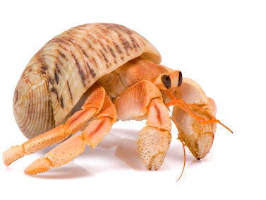
HERMIT CRABS: FLIPPING HOUSES SINCE THE JURASSIC

This little cutie is a hermit crab and he is wearing a temporary home borrowed from one of our mollusc friends. 

His body is a soft, squishy spiral that he eases into the perfect size shell time and time again as he grows. 

His first choice is always the empty shell of a marine snail but will get inventive in a pinch — nuts, wood, serpulid worm tubes, aluminium cans or wee plastic caps. 

They are inventive, polite and patient. 

You see, a hermit crabs' desire for the perfect bit of real estate will have them queueing beside larger shells — shells too large for them — to wait upon a big hermit crab to come along, discard the perfect home and slip into their new curved abode. This is all done in an orderly fashion with the hermit crabs all lined up, biggest to smallest to see who best fits the newly available shell. 

There are over 800 species of hermit crab — decapod crustaceans of the superfamily Paguroidea. Their lineage dates back to the Jurassic, 200 million years ago. Their soft squishy, weakly calcified bodies do not fossilize all that often but when they do the specimens are spectacular. Think of all the species of molluscs these lovelies have had a chance to try on — including ammonites — and all the shells that were never buried in sediment to become fossils because they were harvested as homes.  

On the shores of British Columbia, Canada, the hermit crab I come across most often is the Grainyhand hermit crab, Pagurus granosimanus

These wee fellows have tell-tale orange-brown antennae and olive green legs speckled with blue or white dots. 

In the Kwak̓wala language of the Kwakiutl or Kwakwaka'wakw, speakers of Kwak'wala, of the Pacific Northwest, a shell is known as x̱ala̱'is and gugwis means house on the beach. 

I do not know the Kwak’wala word for a hermit crab, so I will think of these cuties as x̱ala̱'is gugwis — envisioning them finding the perfect sized shell on the surf worn shores of Tsax̱is, Fort Rupert, Vancouver Island. 

Friday 16 February 2024

UPTHRUSTING PLATES: WASHINGTON GEOLOGY

Two hundred million years ago, Washington was two large islands, bits of the continent on the move westward, eventually bumping up against the North American continent and calling it home. The shifting continues, subtly changing the landscape like a breath. We only notice when pockets of resistance manifest as earthquakes, some newsworthy, some all but unnoticed. For now, the more extreme movement has subsided laterally and continues vertically, pushing California towards the North Pole. Hello Baja-BC.

The upthrusting of plates move our mountain ranges skyward – the path of least resistance. And it is this dynamic movement that's created the landscape we see today.

The 3,000 meters of the stratigraphic section of the Chuckanut Formation along Chuckanut Drive span an age range of just a few million years. The lower part is late Paleocene with a radiometric age of around 56 million years. The upper part of the section is early Eocene. The fossils found here lived and died very close to where they are now but in a much warmer, wetter, swampy setting. The exposures of the Chuckanut Formation were once part of a vast river delta; imagine, if you will, the bayou country of the Lower Mississippi. The siltstones, sandstones, mudstones and conglomerates of this formation were laid down during a time of luxuriant plant growth in the subtropical flood plain that covered much of the Pacific Northwest.

This ancient wetland provided ideal conditions to preserve the many trees, shrubs and plants that thrived here giving us a lot of information about climate, temperature, the water cycle and humidity of the region. The Chuckanut flora is made up predominantly of plants whose modern relatives live in tropical areas such as Mexico and Central America. While less abundant, evidence of the animals that called this ancient swamp home are also found here. Rare bird, reptile, and mammal tracks have been immortalized in the outcrops of the Chuckanut Formation.

Sumas Eocene Shorebird Trackway
Tracks of a type of archaic mammal of the Orders Pantodonta or Dinocerata (blunt foot herbivores), footprints from a small shorebird, and tracks from an early equid or webbed bird track give evidence to the vertebrates that inhabited the swamps, lakes and riverways of the Pacific Northwest 50 million years ago.

Fossil mammals and bird trackways from Washington State have caused great excitement over the past few years. Many new trackways have been discovered since the 2009 slides near Sumas. George Mustoe and team collected these important finds, bringing them to the Burke Museum in Washington State to study and make available for display.

The movement of these vertebrates was captured in the soft mud on the banks of an ancient river, one of the only depositional environments favourable for track preservation. The terrestrial paleontological record of Washington State at sites like Chuckanut and Racehorse Creek (U-Pb 53 Ma.) is primarily made up of plant material with some wonderfully enticing mammal, shorebird (seen here) and large Diatryma bird tracks on rare occasions.

Thursday 15 February 2024

DARWIN'S TOXODON

Toxodon is an extinct large grazing mammal. The first Toxodon fossils were discovered by Charles Darwin on his visit to South America as part of his voyage on the HMS Beagle. 

Darwin wondered at the fossil's strange appearance as it seemed to share features with both rodents and rhinos. 

“Toxodon is perhaps one of the strangest animals ever discovered,” wrote Darwin. He first encountered the creature in Uruguay on November 26th, 1834. 

“Having heard of some giant’s bones at a neighbouring farm-house…, I rode there accompanied by my host, and purchased for the value of eighteen pence the head of the Toxodon.”

The beast’s skeleton, once fully assembled, was a baffling mish-mash of traits. It was huge like a rhino, but it had the chiselling incisors of a rodent—its name means “arched tooth”—and the high-placed eyes and nostrils of a manatee or some other aquatic mammal. “How wonderfully are the different orders, at present time so well separated, blended together in different points of the structure of the toxodon!”

Although Toxodon is not related to rodents, in 2015, it was discovered to be distantly related to rhinoceros. 

Wednesday 14 February 2024

NORTH VANCOUVER'S CRETACEOUS CAPILANO RIVER

Cretaceous Plant Material / Three Brothers Formation
Vancouver has a spectacular mix of mountains, forests, lowlands, inlets and rivers all wrapped lovingly by the deep blue of the Salish Sea. 

When we look to the North Shore, the backdrop is made more spectacular by the Coast Mountains with a wee bit of the Cascades tucked in behind.

If you were standing on the top of the Lion's Gate Bridge looking north you would see the Capilano Reservoir is tucked in between the Lions to the west and Mount Seymour to the east on the North Shore. 

The bounty of that reservoir flows directly into your cup. If you look down from the reservoir you see the Capilano River as it makes its way to the sea and enters Burrard Inlet.

The Capilano River on Vancouver's North Shore flows through the Coast Mountains and our coastal rainforest down to the Capilano watershed en route to Burrard Inlet. The headwaters are at the top of Capilano up near Furry Creek. They flow down through the valley, adding in rainwater, snowmelt and many tributaries before flowing into Capilano Lake. The lake in turn flows through Capilano Canyon and feeds into the Capilano River.

Capilano Watershed & Reservoir
Sacred First Nations Land

This area was once the exclusive domain of the Coast Salish First Nations —  xʷmə?kʷəyəm (Musqueam), Skwxwú7mesh (Squamish), and səlilwətaɬ (Tsleil-Waututh) Nations until the early 1800s. 

The Musqueam First Nation are traditional hən̓q̓əmin̓əm̓ speaking people who number a strong and thriving 1,300. Many live today on a wee slip of their traditional territory just south of Marine Drive near the mouth of the Fraser River. 

The Secwepemc or Shuswap First Nations are a collective of 17 bands occupying the south-central part of British Columbia. Their ancestors have lived in the interior of BC, the Secwepemc territories, for at least 10,000 years.

The Coast Salish First Nations have lived in this region for thousands of years — from the mouth of the Columbia River in Oregon to north of Bute Inlet.  

It is to the Squamish Nation that we owe the name of Capilano. In Sḵwx̱wú7mesh snichim or Skwxwú7mesh, their spoken language, Kia'palano/Capilano means beautiful river. Chief Kia'palano (c. 1854-1910) was the Chief of the Squamish Nation from 1895-1910 — known as the Chief of this beautiful river area — Sa7plek.
 
The Cleveland Dam — Capilano River Regional Park

Many things have changed since then, including the Capilano River's path, water levels and sediment deposition. For the salmon who used this path to return home and those who depended on them, life has been forever altered by our hands.

We have Ernest Albert Cleveland to thank for the loss of that salmon but can credit him with much of our drinking water as it is caught and stored by the dam that bears his name. It was his vision to capture the bounty from the watershed and ensure it made its way into our cups and not the sea. 

Both the water and a good deal of sediment from the Capilano would flow into Burrard Inlet if not held back by the 91-metre concrete walls of the Cleveland Dam. While it was not Ernest's intention, his vision and dam had a secondary impact. In moving the mouth of the Capilano River he altered the erosion pattern of the North Shore and unveiled a Cretaceous Plant Fossil outcrop that is part of the Three Brothers Formation.

Capilano River Canyon & Regional Park
Know Before You Go

The fossil site is easily accessible from Vancouver and best visited in the summer months when water levels are low. 

The level of preservation of the fossils is quite good. The state in which they were fossilized, however, was not ideal. They look to have been preserved as debris that gathered in eddies in a stream or delta.

There are Cretaceous fossils found only in the sandstone. You will see exposed shale in the area but it does not contain fossil material. 

Interesting, but again not fossiliferous, are the many granitic and limestone boulders that look to have been brought down by glaciers from as far away as Texada Island. Cretaceous plant material (and modern material) found here include Poplar (cottonwood)  Populus sp. Bigleaf Maple, Acer machphyllum, Alder, Alnus rubra, Buttercup  Ranvuculus sp., Epilobrium, Red cedar, Blackberry and Sword fern.

Capilano Fossil Field Trip:

From downtown Vancouver, drive north through Stanley Park and over the Lion’s Gate Bridge. Take the North Vancouver exit toward the ferries. Turn right onto Taylor Way and then right again at Clyde Avenue. Look for the Park Royal Hotel. Park anywhere along Clyde Avenue.

From Clyde Avenue walk down the path to your left towards the Capilano River. Watch the water level and tread cautiously as it can be slippery if there has been any recent rain. Look for beds of sandstone about 200 meters north of the private bridge and just south of the Highway bridge. The fossil beds are just below the Whytecliff Apartment high rises. Be mindful of high water and slippery rocks.

Visiting the Capilano Watershed and Reservoir:

Visitors can see the reservoir from Cleveland Dam at the north end of Capilano River Regional Park. You can also visit the Capilano River Hatchery, operated below Cleveland Dam since 1971.


Tuesday 13 February 2024

JUVENILE HAMITES SUBROTUNDUS

A tremendously delicate juvenile Hamites subrotundus (J. Sowerby 1814) from Upper Albian outcrops in Mallorca, the largest of the three Balearic Islands in the Mediterranean at more than 3,600 square kilometers. 

Mallorca has been home to various inhabitants for thousands of years. Sitting some 200 kilometers off Spain’s southeastern, it is a idyllic setting for exploring the rich human and geologic history of this part of the world.

The island is made up of dolomite and limestone from a huge expanse of time, the Mesozoic and Cenozoic—170 million to 10 million years ago— and bookended by two parallel mountain chains top and bottom on its southern and northern coasts. 

As you walk the mountain passes northwest to northeast, you stroll across Miocene deposits 20 million to 13 million years ago that speak of the time in our Earth's recent past when part of the African continent collided with Europe. 

It is famous for its limestone mountains and Roman and Moorish remains. As you can see here, it is also home to some rather nice fossils including this specimen of Hamites subrotundus.

While H. subrotundus is generally a Middle Albian species, this specimen was found in the lower part of Upper Albian in the Cristatum zone by José Juárez Ruiz. José had to piece this lovely together from seven fragments. His labour of love was worth the effort. The final piece is sheer perfection and a beautiful specimen approximately 2.5 cm long.

Mallorca and the other Balearic Islands are geologically an extension of the Baetic Cordillera mountain chain of western Andalusia that extends to Murcia and Valencia. 

They are made up of sediments deposited in the Tethys Sea during the Mesozoic.

Exploring the islands, you can collect from deposits from the Triassic, Cretaceous, Jurassic, and Neogene periods. 

The limestone outcrops contain lovely examples of foraminifers—mainly the species Globigerina.

We also see lovely examples of Hamites (Hamites) subrotundus in the Euhoplites loricatus zone; Euhoplites meandrinus subzone from the Middle Albian (Lower Gault) of Folkestone, Kent, UK. 

Photo, preparation and in the collection of the deeply awesome José Juárez Ruiz. Wright C. W. 1996. Treatise on Invertebrate Paleontology (Part L Mollusca 4 Revised) Volume 4: Cretaceous Ammonoidea

Monday 12 February 2024

FOSSILS, LIMESTONE & SALT: HALLSTATT

Hallstatt Salt Mines, Austria / Permian Salt Diapir
The Hallstatt Limestone is the world's richest Triassic ammonite unit, yielding specimens of more than 500 ammonite species.

Along with diversified cephalopod fauna  — orthoceratids, nautiloids, ammonoids — we also see gastropods, bivalves, especially the late Triassic pteriid bivalve Halobia (the halobiids), brachiopods, crinoids and a few corals. We also see a lovely selection of microfauna represented. 

For microfauna, we see conodonts, foraminifera, sponge spicules, radiolaria, floating crinoids and holothurian sclerites —  polyp-like, soft-bodied invertebrate echinozoans often referred to as sea cucumbers because of their similarities in size, elongate shape, and tough skin over a soft interior. 

Franz von Hauer’s exhaustive 1846 tome describing Hallstatt ammonites inspired renowned Austrian geologist Eduard Suess’s detailed study of the area’s Mesozoic history. That work was instrumental in Suess being the first person to recognize the former existence of the Tethys Sea, which he named in 1893 after the sister of Oceanus, the Greek god of the ocean. As part of the Northern Limestone Alps, the Dachstein rock mass, or Hoher Dachstein, is one of the large karstic mountains of Austria and the second-highest mountain in the Northern Limestone Alps. It borders Upper Austria and Styria in central Austria and is the highest point in each of those states.

Parts of the massif also lie in the state of Salzburg, leading to the mountain being referred to as the Drei-Länder-Berg or three-state mountain. Seen from the north, the Dachstein massif is dominated by the glaciers with the rocky summits rising beyond them. By contrast, to the south, the mountain drops almost vertically to the valley floor. The karst limestones and dolomites were deposited in our Mesozoic seas. The geology of the Dachstein massif is dominated by the Dachstein-Kalk Formation — the Dachstein limestone — which dates back to the Triassic.

Hallstatt and the Hallstatt Sea, Austria
There were several phases of mountain building in this part of the world pushing the limestone deposits 3,000 metres above current sea level. The rock strata were originally deposited horizontally, then shifted, broken up and reshaped by the erosive forces of ice ages and erosion.

The Hallstatt mine exploits a Permian salt diapir that makes up some of this area’s oldest rock. 

The salt accumulated by evaporation in the newly opened, and hence shallow, Hallstatt-Meliata Ocean. This was one of several small ocean basins that formed in what is now Europe during the late Paleozoic and early Mesozoic when the world’s landmasses were welded together to form the supercontinent Pangea. 

Pangea was shaped like a crescent moon that cradled the famous Tethys Sea. Subduction of Tethyian oceanic crust caused several slivers of continental crust to separate from Pangea, forming new “back-arc basins” (small oceans formed by rifting that is associated with nearby subduction) between the supercontinent and the newly rifted ribbon continents.

The Hallstatt-Meliata Ocean was one such back-arc basin. As it continued to expand and deepen during the Triassic, evaporation ceased and reefs flourished; thick limestone deposits accumulated atop the salt. When the Hallstatt-Meliata Ocean closed in the Late Jurassic, the compression squeezed the low-density salt into a diapir that rose buoyantly, injecting itself into the Triassic limestones above.

The Hallstatt salt diapir and its overlying limestone cap came to rest in their present position in the northern Austrian Alps when they were shoved northward as nappes (thrust sheets) during two separate collision events, one in the Cretaceous and one in the Eocene, that created the modern Alps. It is from the Hallstatt salt diapir that Hallstatt, like so many cities and towns, gets its name.

Deposits of rock salt or halite, the mineral name of sodium chloride with the chemical formula of NaCl, are found and mined around the globe. These deposits mark the dried remains of ancient oceans and seas. Names of rivers, towns and cities in Europe — Salzburg, Halle, Hallstatt, Hallein, La Salle, Moselle — all pay homage to their connection to halite and salt production. The Greek word for salt is hals and the Latin is sal. The Turkish name for salt is Tuz, which we see in the naming of Tuzla, a salt-producing region of northeastern Bosnia-Herzegovina and in the names of towns that dot the coast of Turkey where it meets the Black Sea. Hallstatt with its salt diapir is no exception.

The salt-named town of Hallstatt sits on the shores of the idyllic Hallstätter Sea at the base of the Dachstein massif. Visiting it today, you experience a quaint traditional fishing village built in the typical upper Austrian style. Tourism drives the economy as much as salt as this area of the world is picture-perfect from every angle.

Space is at a minimum in the town. For centuries, every ten years the local cemetery exhumes the bones of those buried there and moves them to an ossuary to make room for new burials. The Hallstatt Ossuary is called Karner, Charnel House, or simply Beinhaus (Bone House). Karners are places of secondary burials. They were once common in the Eastern Alps, but that custom has largely disappeared.

Hallstatt Beinhaus Ossuary, Hallstatt, Austria
A collection of over 700 elaborately decorated skulls rest inside the ossuary. They are lined up on rows of wooden shelves that grace the walls of the chapel. Another 500 undecorated skulls, bare and without any kind of adornment, are stacked in the corners.

Each is inscribed and attached to a record with the deceased's name, profession and date of death. The Bone House is located in a chapel in the basement of the Church of Saint Michael. The church dates from the 12th century CE. 

Decorating the skulls was traditionally the job of the local gravedigger and an honour granted to very few. At the family's request, garlands of flowers were painted on the skulls of deceased as decorative crowns if they were female. The skulls of men and boys were painted wreaths of oak or ivy.

Every building in Hallstatt looks out over the Hallstätter Sea. This beautiful mountain lake considered one of the finest of Austria's Salzkammergut region. It lies at the northern foot of the Dachstein mountain range, sitting eight-and-a-half kilometres long and two kilometres wide. The shoreline is dotted by the villages of  Obertraun, Steeg, and Hallstatt.

The region is habitat to a variety of diverse flora and fauna, including many rare species such as native orchids, in the wetlands and moors in the south and north.

Linked by road to the cities of Salzburg and Graz, Hallstatt and its lake were declared one of the World Heritage sites in Austria in 1997 and included in the Hallstatt-Dachstein Salzkammergut Alpine UNESCO World Heritage Site. The little market village of Hallstatt takes its name from the local salt mine.

Hallstatt, Salzkammergut region, Austria
The town is a popular tourist destination with its quaint shops and terraced cafes. In the centre of town, the 19th-century Evangelical Church of Hallstatt with its tall, slender spire is a lakeside landmark. You can see it here in the photo on the left.

Above the town are the Hallstatt Salt mines located within the 1,030-meter-tall Salzburg Salt Mountain. They are accessible by cable car or a three-minute journey aboard the funicular railway. There is also a wonderful Subterranean Salt Lake.

In 1734, there was a corpse found here preserved in salt. The fellow became known as the Man in Salt. Though no archaeological analysis was performed at the time — the mummy was respectfully reburied in the Hallstatt cemetery — based on descriptions in the mine records, archaeologists suspect the miner lived during the Iron Age. This Old Father, Senos ph₂tḗr, 'ɸatīr 'father' may have been a local farmer, metal-worker, or both and chatted with his friends and family in Celtic or Proto-Celtic.

Salt mining in the area dates back to the Neolithic period, from the 8th to 5th Centuries BC. This is around the time that Roman legions were withdrawing from Britain and the Goths sacked Rome. In Austria, agricultural settlements were dotting the landscape and the alpine regions were being explored and settled for their easy access to valuable salt, chert and other raw materials.

The salt-rich mountains of Salzkammergut and the upland valley above Hallstatt were attractive for this reason. The area was once home to the Hallstatt culture, an archaeological group linked to Proto-Celtic and early Celtic people of the Early Iron Age in Europe, c.800–450 BC.
Bronze Age vessel with cow and calf

In the 19th century, a burial site was discovered with 2,000 individuals, many of them buried with Bronze Age artefacts of amber and ivory.

It was this find that helped lend the name Hallstatt to this epoch of human history. The Late Iron Age, between around 800 and 400 BC, became known as the Hallstatt Period.

For its rich history, natural beauty and breathtaking mountainous geology, Hallstatt is a truly irresistible corner of the world.

Salzbergstraße 1, 4830 Hallstatt.  https://www.salzwelten.at/en/home/

Photo: Bronze vessel with cow and calf, Hallstatt by Alice Schumacher - Naturhistorisches Museum Wien - A. Kern – K. Kowarik – A. W. Rausch – H. Reschreiter, Salz-Reich. 7000 Jahre Hallstatt, VPA 2 (Wien, 2008) Seite 133 Abbildung 6. Hallstatt Village & Ossuary Photos: P. McClure Photography ca. 2015.

Bernoulli D, Jenkyns HC (1974) Alpine, Mediterranean, and Central Atlantic Mesozoic facies in relation to the early evolution of the Tethys. Soc Econ Paleont Mineral Spec Publ 19:129–160

Bernoulli D, Jenkyns H (2009) Ancient oceans and continental margins of the Alpine-Mediterranean Tethys: deciphering clues from Mesozoic pelagic sediments and ophiolites. Sedimentology 56:149–190

Sunday 11 February 2024

NATURAL DYES: INDIGO

Natural dyes are dyes or colourants derived from plants, invertebrates, or minerals. The majority of natural dyes are vegetable dyes from plant sources — roots, berries, bark, leaves, and wood — and other biological sources such as fungi and lichens.

Archaeologists have found evidence of textile dyeing dating back to the Neolithic period. In China, dyeing with plants, barks and insects has been traced back more than 5,000 years and looks to be our first attempt at the practice of chemistry.

The essential process of dyeing changed little over time. Typically, the dye material is put in a pot of water and then the textiles to be dyed are added to the pot, which is heated and stirred until the colour is transferred. Sometimes, we use workers with stout marching legs to mix this up.

Traditional dye works still operate in many parts of the world. There is a revival of using natural indigo in modern Egypt — although their indigo dye is mostly imported. The same is true further south in Sudan. They've been importing cloth from Upper Egypt as far back as we have written records and continue the practice of the cloth and dye imports today. Clean white cotton is more the style of western Sudan and Chad, but they still like to throw in a bit of colour.

Traditional Dye Vats
So do the folk living in North Africa. Years ago, I was travelling in Marrakesh and saw many men with noticeably orange, blueish or purplish legs. It wasn't one or two but dozens of men and I'd wondered why this was.

My guide took me to the top of a building so I could look down on rows and rows of coloured vats. In every other one was a man marching in place to work the dye into the wool. Their legs took on the colour from their daily march in place in huge tubs of liquid dye and sheared wool. 

This wool would be considered textile fibre dyed before spinning — dyed in the wool — but most textiles are yarn-dyed or piece-dyed after weaving. In either case, the finished product is quite fetching even if the dyer's legs are less so. 

Many natural dyes require the use of chemicals called mordants to bind the dye to the textile fibres; tannin from oak galls, salt, natural alum, vinegar, and ammonia from stale urine were staples of the early dyers.

Many mordants and some dyes themselves produce strong odours. Urine is a bit stinky. Not surprisingly, large-scale dyeworks were often isolated in their own districts.

Woad, Isatis tinctoria
Plant-based dyes such as Woad, Isatis tinctoria, indigo, saffron, and madder were raised commercially and were important trade goods in the economies of Asia and Europe. 

Across Asia and Africa, patterned fabrics were produced using resist dyeing techniques to control the absorption of colour in piece-dyed cloth.

Dyes such as cochineal and logwood, Haematoxylum campechianum, were brought to Europe by the Spanish treasure fleets, and the dyestuffs of Europe were carried by colonists to America.

Throughout history, people have dyed their textiles using common, locally available materials, but scarce dyestuffs that produced brilliant and permanent colours such as the natural invertebrate dyes. Crimson kermes became highly prized luxury items in the ancient and medieval world. Red, yellow and orange shades were fairly easy to procure as they exist as common colourants of plants. It was blue that people sought most of all and purple even more so.

Indigofera tinctoria, a member of the legume or bean family proved just the trick. This lovely plant —  named by the famous Swedish botanist Carl Linneaus, the father of formalized binomial nomenclature — grows in tropical to temperate Asia and subtropical regions, including parts of Africa.

The plants contain the glycoside indican, a molecule that contains a nitrogenous indoxyl molecule with some glucose playing piggyback. 

Indigo dye is a product of the reaction of indoxyl by a mild oxidizing agent, usually just good old oxygen.

To make the lovely blue and purple dyes, we harvest the plants and ferment them in vats with urine and ash. The fermentation splits off the glucose, a wee bit of oxygen mixes in with the air (with those sturdy legs helping) and we get indigotin — the happy luxury dye of royalty, emperors and kings.

While much of our early dye came from plants — now it is mostly synthesized — other critters played a role. Members of the large and varied taxonomic family of predatory sea snails, marine gastropod mollusks, commonly known as murex snails were harvested by the Phoenicians for the vivid dye known as Tyrian purple.

While the extant specimens maintained their royal lineage for quite some time; at least until we were able to manufacture synthetic dyes, it was their fossil brethren that first captured my attention. There are about 1,200 fossil species in the family Muricidae. 

They first appear in the fossil record during the Aptian of the Cretaceous. Their ornate shells fossilize beautifully. I first read about them in Addicott's Miocene Gastropods and Biostratigraphy of the Kern River Area, California. It is a wonderful survey of 182 early and middle Miocene gastropod taxa.

References:

George E. Radwin and Anthony D'Attilio: The Murex shells of the World, Stanford University press, 1976, ISBN 0-8047-0897-5

Pappalardo P., Rodríguez-Serrano E. & Fernández M. (2014). "Correlated Evolution between Mode of Larval Development and Habitat in Muricid Gastropods". PLoS ONE 9(4): e94104. doi:10.1371/journal.pone.0094104

Miocene Gastropods and Biostratigraphy of the Kern River Area, California; United States Geological Survey Professional Paper 642  

Saturday 10 February 2024

YORKSHIRE HISTORY: FOSSILS TEXTILES AND URINE

Yorkshire Coast
You may recall the eight-metre Type Specimen of the ichthyosaur, Temnodontosaurus crassimanus, found in an alum quarry in Yorkshire, northern England.

The Yorkshire Museum was given this important ichthyosaur fossil back in 1857 when alum production was still a necessary staple of the textile industry. Without that industry, many wonderful specimens would likely never have been unearthed.

These quarries are an interesting bit of British history as they helped shape the Yorkshire Coast, created an entirely new industry and gave us more than a fixative for dyes. With them came the discovery of many remarkable fossil specimens and, oddly, local employment in the collection of urine.

In the 16th century, alum was essential in the textile industry as a fixative for dyes. 

By the first half of the 16th century, the clothing of the Low Countries, German states, and Scandinavia had developed in a different direction than that of England, France, and Italy, although all absorbed the sobering and formal influence of Spanish dress after the mid-1520s. Those fashions held true until the Inquisition when religious persecution, politics and fashion underwent a much-needed overhaul to something lighter.

Fashion in Medieval Livonia (1521): Albrecht Dürer
Elaborate slashing was popular, especially in Germany. In the depiction you see here, an artist pokes a bit of fun at Germanic fashion from the time. Bobbin lace arose from passementerie in the mid-16th century in Flanders, the Flemish Dutch-speaking northern portion of Belgium. Black was increasingly worn for the most formal occasions.

This century saw the rise of the ruff, which grew from a mere ruffle at the neckline to immense, slightly silly, cartwheel shapes. They adorned the necklines of the ultra-wealthy and uber-stylish men and women of the age.

At their most extravagant, ruffs required wire supports and were made of fine Italian reticella, a cutwork linen lace. You can imagine the many hours of skill and patience that would have gone into each piece to create the artful framework of these showy lace collars.

16th Century Fashion / Ruff Collars and Finery
In contrast to all that ruff, lace and cutwork linen, folk needed dyed fabrics. And to fix those dyes, they needed Alum. For a time, Italy was the source of that alum.

The Pope held a tidy monopoly on the industry, supplying both alum and the best dyes. He also did a nice trade in colourful and rare pigments for painting. And for a time, all was well with dandy's strutting their finery to the local fops in Britain.

All that changed during the Reformation. Great Britain, heathens as they were, were cut off from their Papal source and needed to fend for themselves.

The good Thomas Challoner took up the charge and set up Britain's first Alum works in Guisborough. Challoner looked to palaeontology for inspiration. Noticing that the fossils found on the Yorkshire coast were very similar to those found in the Alum quarries in Europe, he hatched a plan to set-up an alum industry on home soil. 

As the industry grew, sites along the coast were favoured as access to the shales and subsequent transportation was much easier.

Alum House, Photo: Joyce Dobson and Keith Bowers
Alum was extracted from quarried shales through a large scale and complicated process which took months to complete. 

The process involved extracting then burning huge piles of shale for 9 months, before transferring it to leaching pits to extract an aluminium sulphate liquor. This was sent along channels to the alum works where human urine was added.

At the peak of alum production, the industry required 200 tonnes of urine every year. That's the equivalent of all the potty visits of more than 1,000 people. Yes, strange but true.

The steady demand was hard to keep up with and urine became an imported resource from markets as far away as London and Newcastle upon Tyne in the northeast of England. Wooden buckets were left on street corners for folk to do their business then carted back to the south to complete the alum extraction process. The urine and alum would be mixed into a thick liquid. Once mixed, the aromatic slosh was left to settle and then the alum crystals were removed.

I'm not sure if this is a folktale or plain truth, but as the story goes, one knows when the optimum amount of alum had been extracted as you can pop an egg in the bucket and it floats on its own.

Alum House. Photo: Ann Wedgewood and Keith Bowers
The last Alum works on the Yorkshire Coast closed in 1871. This was due to the invention of manufacturing synthetic alum in 1855, then subsequently the creation of aniline dyes that contained their own fixative.

Many sites along the Yorkshire Coast bear evidence of the alum industry. These include Loftus Alum Quarries where the cliff profile is drastically changed by extraction and huge shale tips remain.

Further South are the Ravenscar Alum Works, which are well-preserved and enable visitors to visualize the processes which took place. The photos you see here are of Alum House at Hummersea. The first shows the ruin of Alum House printed on a postcard from 1906. The second (bottom) image shows the same ruin from on high with Cattersty Point in the background.

The good folk at the National Trust in Swindon are to thank for much of the background shared here. If you'd like to learn more about the Yorkshire area or donate to a very worthy charity, follow their link below.

Reference: https://www.nationaltrust.org.uk/yorkshire-coast/features/how-alum-shaped-the-yorkshire-coast

Friday 9 February 2024

ANAHOPLITES PLANUS OF FRANCE

A beautiful specimen of the ammonite, Anahoplites planus (Mantell, 1822) from Albian deposits in Villemoyenne Quarry, Courcelles, Aube, north-central France.

Anahoplites (Hyatt, 1900) is a genus of compressed hoplitid ammonites with flat sides, narrow, flat or grooved venters, and flexious ribs or striae arising from weak umbilical tubercles that end in fine dense ventrolateral nodes.

This lovely has attracted some roommates — an oyster, some bryozoans and worm tubes are attached to her shell.

Anahoplites is now included in the subfamily Anahoplitinae and separated from the Hoplitinae where it was placed in the older in the 1957 edition of the Treatise on Invertebrate Paleontology, Part L (Ammonoidea). Genera of the Hoplitinae tend to be more robust, with broader whorls and stronger ribs.

Anahoplites is found in Cretaceous (Middle to the Late Albian) deposits from England, through Europe, all the way to the Transcaspian Oblast region in Russia to the east of the Caspian Sea. The Aube department, named after the local river, is the type locality of the Albian stage (d'ORBIGNY, 1842). 

A. planus from the French Coast
Two formations are recognized in the clay facies (the "Gault" auct.) of the stratotype, the Argiles tégulines de Courcelles (82 m), overlain by the Marnes de Brienne (43 m). The boundary between the two formations is well-defined at the top of an indurated bed and readily identifiable in the field.

This involute (113 mm) specimen shows evidence of cohabitation by some of his marine peers. 

We see two different bryozoa, an oyster and some serpulids making a living and leaving trace fossils on her flat sides. The top specimen was prepared with potase by José Juárez Ruiz of Spain. 

The lovely Anahoplites planus you see here to the lower right was found by Bertus op den Dries on the French coast in Albian deposits near Wissant, P5 and measures in at 8 cm. This on edge view gives you a very good sense of the keel.

Thursday 8 February 2024

K'ULUT'A: PLAYFUL PORPOISE OF THE PACIFIC NORTHWEST

Dall's Porpoise
These delightfully friendly and super smart fellows are Dall's porpoise. 

In the Kwak̓wala language of the Kwakiutl or Kwakwaka'wakw, speakers of Kwak'wala, of the Pacific Northwest, a blowhole is known as a ka̱'was, whether on a dolphin (porpoise) or whale and a porpoise is known as a k̓ulut̕a

In the Pacific Northwest, we see many of their kind — the shy, blunt-nosed harbour porpoise, the social and herd-minded Pacific white-sided dolphin and the showy and social Dall's porpoise.  

Of these, the Dall's porpoise is a particular favourite. These speedy muscular black and white showboats like to ride the bow waves of passing boats — something they clearly enjoy and a thrill for everyone on board the vessel. If you slow down, they will often whisk away, but give them a chance to race you and they may stay with you all afternoon. 

Harbour porpoises are the complete opposite. You are much more likely to see their solid black bodies and wee fin skimming through the waves across the bay as they try to avoid you entirely. Harbour porpoise prefer quiet sheltered shorelines, often exploring solo or in small groups of two or three. 

We sometimes see these lovely marine mammals represented in the art of the First Nations in the Pacific Northwest, particularly along the coast of British Columbia. You will know them from their rather rectangular artistic depiction with a pronounced snout and lacking teeth (though they have them) used to portray killer whales or orca. 

As a group, even considering the shy Harbour porpoise, these marine mammals are social and playful. Humpback whales are fond of them and you will sometimes see them hanging out altogether in the bays and inlets or near the shore. 

They are quite vocal, making lots of distinctive and interesting noises in the water. They squeak, squawk and use body language — leaping from the water while snapping their jaws and slapping their tails on the surface. They love to blow bubbles, will swim right up to you for a kiss and cuddle. 

Each individual has a signature sound, a whistle that is uniquely their own. They use these whistles to tell one of their friends and family members from another.

Porpoise are marine mammals that live in our world's oceans. If it is salty and cold, you can be pretty sure they are there. They breathe air at the surface, similar to humans, using their lungs and inhaling and exhaling through a blowhole at the top of their heads instead of through their snouts. 


Wednesday 7 February 2024

VANCOUVER ISLAND'S TRENT RIVER PALAEONTOLOGY

Dan Bowen, Chair, VIPS, Trent River
The rocks that make up the Trent River on Vancouver Island are on the move. They were laid down near of the equator as small, tropical islands. They rode across the Pacific heading north and slightly east over the past 85 million years to where we find them today.

The Pacific Plate is an oceanic tectonic plate that lies beneath the Pacific Ocean. And it is massive. At 103 million km2 (40 million sq mi), it is the largest tectonic plate and continues to grow fed by volcanic eruptions that piggyback onto its trailing edge.

This relentless expansion pushes the Pacific Plate into the North American Plate. The pressure subducts it beneath our continent where it then melts back into the earth. Plate tectonics are slow but powerful forces. 

The island chains that rode the plates across the Pacific smashed into our coastline and slowly built the province of British Columbia. And because each of those islands had a different origin, they create pockets of interesting and diverse geology.

It is these islands that make up the Insular Belt — a physio-geological region on the northwestern North American coast. It consists of three major island groups — and many smaller islands — that stretches from southern British Columbia up into Alaska and the Yukon. These bits of islands on the move arrived from the Late Cretaceous through the Eocene — and continues to this day.

The rocks that form the Insular Superterrane are allochthonous, meaning they are not related to the rest of the North American continent. The rocks we walk over along the Trent River are distinct from those we find throughout the rest of Vancouver Island, Haida Gwaii, the rest of the province of British Columbia and completely foreign to those we find next door in Alberta.

To discover what we do find on the Trent takes only a wee stroll, a bit of digging and time to put all the pieces of the puzzle together. The first geological forays to Vancouver Island were to look for coal deposits, the profitable remains of ancient forests that could be burned to the power industry.

Jim Monger and Charlie Ross of the Geological Survey of Canada both worked to further our knowledge of the complex geology of the Comox Basin. They were at the cutting edge of west coast geology in the 1970s. It was their work that helped tease out how and where the rocks we see along the Trent today were formed and made their way north.

We know from their work that by 85 million years ago, the Insular Superterrane had made its way to what is now British Columbia. 

The lands were forested much as they are now but by extinct genera and families. The fossil remains of trees similar to oak, poplar, maple and ash can be found along the Trent and Vancouver Island. We also see the lovely remains of flowering plants such as Cupanities crenularis, figs and breadfruit.

Heading up the river, you come to a delineation zone that clearly marks the contact between the dark grey marine shales and mudstones of the Haslam Formation where they meet the sandstones of the Comox Formation. Fossilized material is less abundant in the Comox sandstones but still contains some interesting specimens. Here you begin to see fossilized wood and identifiable fossil plant material.

Further upstream, there is a small tributary, Idle Creek, where you can find more of this terrestrial material in the sandy shales. As you walk up, you see identifiable fossil plants beneath your feet and jungle-like, overgrown moss-covered, snarly trees all around you.

Walking west from the Trent River Falls at the bottom, you pass the infamous Ammonite Alley, where you can find Mesopuzosia sp. and Kitchinites sp. of the Upper Cretaceous (Santonian), Haslam Formation. Minding the slippery green algae covering some of the river rocks, you can see the first of the Polytychoceras vancouverense zone.

Continuing west, you reach the first of two fossil turtle sites on the river — amazingly, one terrestrial and one marine. If you continue, you come to the Inland Island Highway.

The Trent River has yielded some very interesting marine specimens, and significant terrestrial finds. We have found a wonderful terrestrial helochelydrid turtle, Naomichelys speciosa, and the caudal vertebrae of a Hadrosauroid dinosaur. Walking down from the Hadrosaur site you come to the site of the fossil ratfish find — one of the ocean's oddest fish.

Ratfish, Hydrolagus Collie, are chimaera found in the north-eastern Pacific Ocean today. The fossil specimen from the Trent would be considered large by modern standards as it is a bruiser in comparison to his modern counterparts. 

This robust fellow had exceptionally large eyes and sex organs that dangled enticingly between them. You mock, but there are many ratfish who would differ. While inherently sexy by ratfish standards, this fellow was not particularly tasty to their ancient marine brethren (or humans today) — so not hugely sought after as a food source or prey.

A little further again from the ratfish site we reach the contact of the two Formations. The rocks here have travelled a long way to their current location. With them, we peel away the layers of the geologic history of both the Comox Valley and the province of British Columbia.

The Trent River is not far from the Puntledge, a river whose banks have also revealed many wonderful fossil specimens. The Puntledge is also the name used by the K'ómoks First Nation to describe themselves. They have lived here since time immemorial. Along with Puntledge, they refer to themselves as Sahtloot, Sasitla and Ieeksun.

References: Note on the occurrence of the marine turtle Desmatochelys (Reptilia: Chelonioidea) from the Upper Cretaceous of Vancouver Island Elizabeth L. Nicholls Canadian Journal of Earth Sciences (1992) 29 (2): 377–380. https://doi.org/10.1139/e92-033; References: Chimaeras - The Neglected Chondrichthyans". Elasmo-research.org. Retrieved 2017-07-01.

Directions: If you're keen to explore the area, park on the side of Highway 19 about three kilometres south of Courtenay and hike up to the Trent River. Begin to look for parking about three kilometres south of the Cumberland Interchange. There is a trail that leads from the highway down beneath the bridge which will bring you to the Trent River's north side.

Monday 5 February 2024

CARNOTAURUS SASTREI: FLESH EATING BULL

Carnotaurus sastrei, a genus of large theropod dinosaurs that roamed the southern tip of Argentina, South America during the Late Cretaceous, 72 to 69.9 million years ago. His name means "flesh-eating bull,' and he lives up to it.

This fellow — or at least his robust skull with the short, knobby eyebrow horns and fierce-looking teeth — is on display at the Natural History Museum in Madrid, Spain. For now, he is the only known genus of this species of bipedal predator.

The first specimen of Carnotaurus sastrei was found in Chubut on vast plains between the Andes Mountains and the Atlantic Ocean. A physician, Dr. A'ngel Tailor noticed a large concretion showing some bone fragments. A team led by José F. Bonaparte excavated the find in 1984 as part of a paleontological expedition funded by the Argentine Museum of Natural Sciences.

Sadly, Bonaparte — the Maestro del Mesozoico — passed away the 18th February 20220 at the age of 91. He spent the majority of his career as head of the Vertebrate Palaeontology Division of the Museo Argentino de Ciencias Naturales “Bernardino Rivadavia,” in Buenos Aires. Bonaparte opened up the vertebrate finds of Argentina to the world. He was instrumental in the finding, excavating and naming many iconic dinosaurs — Carnotaurus, Amargasaurus, Abelisaurus, Argentinosaurus, Noasaurus along with the finding of the first fossilised remains of Mesozoic South American mammals. He mentored many palaeontologists who will miss his keen eye and tremendous work ethic — Luis Chiappe, Rodolfo Coria, Agustín Martinelli, Fernando Novas, Jaime Powell, Guillermo Rougier, Leonardo Salgado, Sebastián Apesteguía and many others.

His excavation of Carnotaurus was the first of its kind and he recognized that the skull is quite unusual. Initially, it has a very marine reptile feel — but make no mistake this guy is clearly a terrestrial theropod. He had smallish, underdeveloped arms — teeny by theropod standards. Once you look closer you see his bull-like horns from whence he gets his name — horns that imply battle between rivals for the best meal, sexual partner and to be the one who leads the herd. 

He was covered in leathery skin lined with rows of cone-shaped nodules or bumps. These get larger as they move towards his spine. He had forward-facing eyes, similar to tyrannosaurs like T-rex and smaller theropods like Velociraptor and Troodon — who had better vision even that T-rex — which would have given him the advantage of binocular vision and depth perception. Forward-facing eyes are also quite helpful with nocturnal hunting — think owls and cats — as they take in more light and help with nighttime predation. So perhaps this flesh-eating bull fancied a late-night snack on his menu from time to time.

Species like squirrels, pigeons and crocodiles have eyes on the sides of their heads. They lack the important competitive feature of well-developed depth perception — being able to easily and estimate distance — but perhaps make up for it with a panorama that offers a wider field of view.   

Sunday 4 February 2024

SQUIRRELS: SHADOW TAILS

One of the little animals I see daily in Kitsilano, Vancouver, are the very busy, highly comic rodents we know as squirrels. 

They spend their days busily gathering and caching food and their nights resting from all that hard work. 

My neighbourhood has mostly Eastern Gray squirrels, Sciurus carolinensis (Gmelin, 1788) who come in a colour palette of reddish-brown, grey (British spelling) and black. 

These cuties have bushy tails and a spring in their step — racing around gathering nuts, finding secret hiding spots to cache them, teasing dogs and generally exuding cuteness.

We find the first fossil evidence of tree squirrels in the Pleistocene. At least twenty specimens have been found of Sciurus carolinensis in Pleistocene outcrops in Florida on the eastern coast of the United States. Over time, their body size grew larger then shrunk down to the 400 to 600 g (14 to 21 oz) weight we see them today.  

Eastern Gray squirrels have two breeding seasons in December-January and June-July. This past year was warm. On Vancouver Island, the Eastern Grays bred again in early September. One wonders if the heat dome killed off the July litter, and with the return of more favourable weather, the parents have been induced to breed again.

While they are not native to Vancouver, they are plentiful. They were introduced to the region over a hundred years ago and have been happily multiplying year upon year. 

Our native species are the smaller, reddish-brown, rather shy Douglas squirrels, Tamiasciurus douglasii (Bachman, 1839), and the nocturnal Northern Flying Squirrels, Glaucomys sabrinus (Shaw, 1801).  

Sciurus, is derived from two Greek words, skia, meaning shadow, and oura, meaning tail. The name choice is poetic, alluding to squirrels sitting in the shadow of their tails. 

The specific epithet, carolinensis, refers to the Carolinas on the eastern seaboard of the United States, an area that includes both North and South Carolina. It was here that the species was first recorded and still rather common. In the United Kingdom and Canada, Sciurus carolinensis is referred to as the Eastern Gray or grey squirrel — and though adorable is an invasive species. 

In the United States, Eastern is used to differentiate the species from the Western Gray or Silver-Gray squirrel, Sciurus griseus, (Ord, 1818). 

The Ord here, of course, is George Ord, the American zoologist who named the species based on notes recorded by Lewis and Clark in the early 1800s. If you fancy a read, check out his article from 1815, "Zoology of North America." It is charming, anachronistic and the first systemic zoology of America by an American. 

In the Kwak̓wala language of the Kwakwaka'wakw First Nation, speakers of Kwak'wala, of the Pacific Northwest, we use the word ta̱minasux̱, to say: "that is a squirrel." 

The word for shadow in Kwak'wala is gagumas and tail is ha̱t̕sa̱x̱ste' — so I will think of these wee wonders of the Order Rodentia in the family Sciuridae as the Gagumas ha̱t̕sa̱x̱ste' of Khahtsahlano. 

Saturday 3 February 2024

OPHTHALMOPLAX BRASILIANA

Ophthalmoplax brasiliana  / Photo: José F. Ventura‎
Ventral view of the carnivorous portunoid crab Ophthalmoplax brasiliana (Maury, 1930) from the latest Maastrichtian (~66.2 Ma.) deposits near Coahuila, northern Mexico.

This marine species was originally thought to have been found only in the upper Member (Owl Creek Formation) Late/Upper Maastrichtian deposits of Tippah County in Mississippi, USA. 

Sohl and Koch published on the Mississippian finds in the USGS in 1983. Fedorov and Nyborg published on this same species again in 2017. Paleocoordinates: (34.8° N, 88.9° W: 38.3° N, 66.2° W)

Friday 2 February 2024

CHAMPAGNE-ARDENNE HOPLITES

An excellent example of the ammonite, Hoplites bennettiana (Sowby, 1826) with a pathology. This beauty is from Albian deposits near Carrière de Courcelles, Villemoyenne, laid down in the Cretaceous near la région de Troyes (Aube) Champagne in northeastern France.

L'Albien or Albian is both an age of the geologic timescale and a stage in the stratigraphic column. It was named after Alba, the Latin name for the River Aube, a tributary of the Seine that flows through the Champagne-Ardenne region of northwestern France.

The Albian is the youngest or uppermost subdivision of the Lower Cretaceous, approximately 113.0 ± 1.0 Ma to 100.5 ± 0.9 Ma (million years ago).

At the time that this fellow was swimming in our oceans, ankylosaurs were strolling about Mongolia and stomping through the foliage in Utah, Kansas and Texas. Bony fish were swimming over what would become the strata making up Canada, the Czech Republic and Australia. Cartilaginous fish were prowling the western interior seaway of North America and a strange extinct herbivorous mammal, Eobaatar, was snuffling through Mongolia, Spain and England. Interesting times.

Hoplites maritimus / Hoplites rudis
Hoplites are amongst my favourite ammonites. I still have a difficult time telling them apart. To the right, you can see a slightly greyish, Hoplites maritimus, from Sussex England. Below him is a brownish Hoplites rudis from outcrops between Courcelles and Troyes, France. There are many Hoplites species. Each has a nicely raised tire-track ribbing. My preference is for Hoplities bennetianus (or bennettiana). I'm still sorting out the naming of that species. The difference between Hoplites bennettiana and Hoplites dentatus is seen on the venter.

Hoplites shells have compressed, rectangular and trapezoidal whorl sections. They have pronounced umbilical bullae from which their prominent ribs branch out. The ends of the ribs can be both alternate or opposite. Some species have zigzagging ribs and these usually end thickened or raised into ventrolateral tubercules.

Ammonites were predatory, squid-like creatures that lived inside coil-shaped shells. Like other cephalopods, ammonites had sharp, beaklike jaws inside a ring of tentacles that extended from their shells to snare prey such as small fish and crustaceans. Some ammonites grew more than three feet (one meter) across — possible snack food for the giant mosasaur Tylosaurus.

Ammonites constantly built new shell as they grew, but only lived in the outer chamber. They scooted through the warm, shallow seas by squirting jets of water from their bodies. A thin, tubelike structure called a siphuncle reached into the interior chambers to pump and siphon air and helped them move through the water.

Ammonites first appeared about 240 million years ago, though they descended from straight-shelled cephalopods called bacrites that date back to the Devonian, about 415 million years ago. They were prolific breeders, lived in schools, and are among the most abundant fossils found today. They went extinct with the dinosaurs 65 million years ago. Scientists use the various shapes and sizes of ammonite shells that appeared and disappeared through the ages to date other fossils.

Hoplites sp. from the Early Cretaceous of Dorset, UK
During their evolution, three catastrophic events occurred. The first during the Permian period (250million years ago), only 10% survived.  They went on to flourish throughout the Triassic period, but at the end of this period (206 million years ago), all but one species died. Then they began to thrive from the Jurassic period until the end of the Cretaceous period when all species of ammonites became extinct.

Ammonites began life very tiny, less than 1mm in diameter, and were vulnerable to attack from predators. They fed on plankton and quickly assumed a strong protective outer shell. They also grew quickly with the females growing up to 400% larger than the males; because they needed the larger shell for egg production. Most ammonites only lived for two years.  Some lived longer becoming very large. The largest ever found was in Germany (6.5 feet in diameter).

Ammonites lived in shallow waters of 100 meters or less. They moved through the water by jet propulsion expelling water through a funnel-like opening to propel themselves in the opposite direction. They were predators (cephalopods) feeding on most living marine life including mollusks, fish even other cephalopods. Ammonites would silently stalk their prey then quickly extend their tentacles to grab it.  When caught the prey would be devoured by the Ammonites' jaws located at the base of the tentacles between the eyes.

Hoplites dentalus, from Albian deposits near Troyes, France
Most ammonites have coiled shells. The chambered part of the shell is called a phragmocone.  It contains a series of progressively layered chambers called camerae, which were divided by thin walls called septae. The last chamber is the body chamber.

As the ammonite grew, it added new and larger chambers to the opened end of the shell. A thin living tube called a siphuncle passed through the septa, extending from the body to the empty shell chambers.

This allowed the ammonite to empty water out of the shell chambers by hyperosmotic active transport process. This process controlled the buoyancy of the ammonite's shell.

First Photo: Hoplites Bennettiana from near Troyes, France. Collection de Christophe Marot

Second Photo: Top: Hoplites maritimus from Sussex, UK. Bottom: Hoplites rudis from near Troyes, France. Collection of Mark O'Dell

Third Photo: Hoplites sp. from the Early Cretaceous of Dorset, UK. Natural Selection Fossils

Fourth Photo: Hoplites dentalus from Albian deposits near Troyes, France. Collection of Stéphane Rolland.

Wright, C. W. (1996). Treatise on Invertebrate Paleontology, Part L, Mollusca 4: Cretaceous Ammonoidea (with contributions by JH Calloman (sic) and MK Howarth). Geological Survey of America and University of Kansas, Boulder, Colorado, and Lawrence, Kansas, 362.

Amédro, F., Matrion, B., Magniez-Jannin, F., & Touch, R. (2014). La limite Albien inférieur-Albien moyen dans l’Albien type de l’Aube (France): ammonites, foraminifères, séquences. Revue de Paléobiologie, 33(1), 159-279.

Thursday 1 February 2024

AMMONITE OF THE RHÔNE

An exquisite specimen of the delicately ridged ammonite, Porpoceras verticosum, from Middle Toarcian outcrops adjacent the Rhône in southeastern France.

Porpoceras (Buchman, 1911) is a genus of ammonite that lived during the early and middle Toarcian stage of the Early Jurassic. We see members of this genus from the uppermost part of Serpentinum Zone to Variabilis Subzone. These beauties are found in Europe, Asia, North America and South America.

Ammonites belonging to this genus have evolute shells, with compressed to depressed whorl section. Flanks were slightly convex and venter has been low. The whorl section is sub-rectangular. 

The rib is pronounced and somewhat fibulate on the inner whorls — just wee nodes here — and tuberculate to spined on the ventrolateral shoulder. It differs from Peronoceras by not having a compressed whorl section and regular nodes or fibulation. Catacoeloceras is also similar, but it has regular ventrolateral tubercules and is missing the classic nodes or fibulation of his cousins.

This specimen hails from southern France near the Rhône, one of the major rivers of Europe. It has twice the average water level of the Loire and is fed by the Rhône Glacier in the Swiss Alps at the far eastern end of the Swiss canton of Valais then passes through Lake Geneva before running through southeastern France. This 10 cm specimen was prepared by the supremely talented José Juárez Ruiz

Wednesday 31 January 2024

H. SAVENYEI: RENE'S BEE

This is a tale of friendship, tragic loss and fossil bees and an introduction to one of the most delightful paleo enthusiasts I have ever had the pleasure to know and collect with — Rene Savenye. He and I enjoyed many years of waxing poetic about our shared love of palaeontology and natural history. 

Rene was a mountain goat in the field, stalking the hills in his signature red t-shirt. He was tremendously knowledgeable about the natural world and delighted in it. For many years, he was Chair of the White Rock and Surrey Naturalists, while I was Chair of the Vancouver Paleontological Society. Together, we would plan and often co-lead field trips to many of the wonderful fossil outcrops in British Columbia and Washington state. 

In 2002, we were planning a very exciting round of field trips. I was offered a fully paid trip to India with Karen Lund to hike to the headwaters of the Ganges, a trip which I was to forgo in favour of a hike up to the outcrops of the Cathedral Escarpment and Burgess Shale and then to yummy Lower Jurassic and Lower Cretaceous, Albian, outcrops accessed only by boat in Haida Gwaii. 

Rene and I had talked about "walking in the shoes" of Joseph Whiteaves, the GSC's chief palaeontologist in Ottawa. He published a paper in 1876 describing the Jurassic and Cretaceous faunas of Skidegate Inlet and spent a significant portion of his career working out the fossil fauna of the Burgess Shale. Combining these two sites within the same field season was a fitting homage. 

John Fam, Vancouver Paleontological Society (VanPS) and Dan Bowen, Vancouver Island Palaeontological Society (VIPS), did much of the planning for that Haida Gwaii trip, they too being inspired by Whiteaves papers and the work of James Richardson and George Dawson — as a whole, we were giddy with the prospect of the year ahead.

Rene and I had planned to do both, but in the end, I had to give up the hike to Burgess that year and Rene never made it back to join me in Haida Gwaii. 

Rene Savenye
In the days before the official trip to Burgess, Rene did some solo hiking in the mountains and hills near Field, British Columbia. He was excited to test his stamina against the steep passes that protect the majestic ridges of Wapta Mountain, Mount Field and Mount Stephen — ever mindful of collecting only with his camera. 

He walked through the hallowed footsteps of Joseph Whiteaves and Charles Doolittle Walcott over ground that should have been named La Entrada de Dios, The Gateway of God, for each footfall brought him closer to meeting the big man. While a naturalist, Rene held to the belief that once his days were done on this Earth, he would be breaking bread in heaven above. 

Rene started with clear skies and a pack full of geology hammers, maps and chisels — the hillside a sea of white and pink flecked wildflowers in the sunlight. As the day went on, the skies filled with rolling clouds, then thunder. Grey sheets of rain covered the landscape. Seeing the danger of being solo in darkening weather, he started down the slope back to his car — his shadow long and thin striking out before him in the fading light — but he never made it. On the afternoon of July 28th, he was struck and killed by lightning — a tragic loss. 

I take heart that he lived and died doing what he loved most. I got the news a few days later and cried for the loss of a great friend. I am sharing my memory of him with you so that you can remember him, too, and share in the delight and loss of one of the loveliest men to ever walk our planet. His years of teaching, mentoring, encouragement and generosity have helped shape natural science and those who have gone on to make it their passion or career — or happily, both.   

Rene's name will not be forgotten to science. His namesake, H. Savenyei, is a lovely fossil halictine bee from Early Eocene deposits near Quilchena, British Columbia — and the first bee body-fossil known from the Okanagan Highlands — and indeed from Canada. 

As a school teacher, Rene once taught the, then student, now SFU biology instructor, Rolf Mathewes. Rene passed his scientifically valuable specimen to Mathews, knowing it was important to science. Mathewes brought it to the attention of Bruce Archibald and Michael Engel, who described Rene's bee in the Canadian Journal of Zoology. Their work is a lovely legacy to a wonderful man and a specimen from one of his favourite collecting sites — Quilchena — a small road-cut exposure of the Coldwater beds of the Princeton Group, one of several depositional basins in the Merritt region of south-central British Columbia.

Rene is also remembered in spirit by the British Columbia Paleontological Alliance (BCPA) Rene Savenye Award. It was established in 2003 to honour those who have demonstrated outstanding service to the science of palaeontology or to palaeontological education in British Columbia. 

Notable past recipients are a veritable who's who from the Pacific Northwest — Graham Beard of Qualicum in 2005, Charles Helm of Tumbler Ridge in 2011, Pat Trask of Courtenay in 2014, Rod Bartlett in 2016, and Joseph "Joe" Haegert in 2018. I'll share a link to the award below so you can read more at your leisure about Rene and those who bear the award with his name.

About H. Savenyei, (Engel & Archibald, 2003): The type specimen is a fairly well preserved complete adult female preserved with portions of the fore-wings and hind-wings. The specimen is 7.04 millimetres (0.277 in) long with the possibility of alteration in length during fossilization. The sections of the forewing which are preserved are approximately 4.8 millimetres (0.19 in) long and show dark brown to black colouration. The presence of a pygidial plate bordered by setae on the fifth metasomal tergum supports the placement into the Halictidae subfamily Halictinae. Placement into the tribe Halictini is based on the lack of a medial cleft in the fifth tergum.

References:

Archibald, B. & R. W. Mathewes. 2000. “Early Eocene Insects from Quilchena, BC, and their Paleoclimatic Implications.” Canadian Journal of Zoology, Volume 78, Number 6: pp 1441-1462.

Grimaldi, D. 1999. “The Co-radiations of Pollinating Insects and Angiosperms in the Cretaceous.” Annals of the Missouri Botanical Garden. 86: 373-406.

Photo: Halictidae sp.; Archibald and Mathewes 2000: 1453.

Rene Savenye Award: https://bcfossils.ca/rene-savenye-award