Thursday 21 March 2024

FRACTAL BUILDING: AMMONITES

Argonauticeras besairei, Collection of José Juárez Ruiz.
An exceptional example of fractal building of an ammonite septum, in this clytoceratid Argonauticeras besairei from the awesome José Juárez Ruiz.

Ammonites were predatory, squid-like creatures that lived inside coil-shaped shells.

Like other cephalopods, ammonites had sharp, beak-like jaws inside a ring of squid-like tentacles that extended from their shells. They used these tentacles to snare prey, — plankton, vegetation, fish and crustaceans — similar to the way a squid or octopus hunt today.

Catching a fish with your hands is no easy feat, as I'm sure you know. But the Ammonites were skilled and successful hunters. They caught their prey while swimming and floating in the water column. Within their shells, they had a number of chambers, called septa, filled with gas or fluid that were interconnected by a wee air tube. By pushing air in or out, they were able to control their buoyancy in the water column.

They lived in the last chamber of their shells, continuously building new shell material as they grew. As each new chamber was added, the squid-like body of the ammonite would move down to occupy the final outside chamber.

They were a group of extinct marine mollusc animals in the subclass Ammonoidea of the class Cephalopoda. These molluscs, commonly referred to as ammonites, are more closely related to living coleoids — octopuses, squid, and cuttlefish) than they are to shelled nautiloids such as the living Nautilus species.

The Ammonoidea can be divided into six orders:
  • Agoniatitida, Lower Devonian - Middle Devonian
  • Clymeniida, Upper Devonian
  • Goniatitida, Middle Devonian - Upper Permian
  • Prolecanitida, Upper Devonian - Upper Triassic
  • Ceratitida, Upper Permian - Upper Triassic
  • Ammonitida, Lower Jurassic - Upper Cretaceous
Ammonites have intricate and complex patterns on their shells called sutures. The suture patterns differ across species and tell us what time period the ammonite is from. If they are geometric with numerous undivided lobes and saddles and eight lobes around the conch, we refer to their pattern as goniatitic, a characteristic of Paleozoic ammonites.

If they are ceratitic with lobes that have subdivided tips; giving them a saw-toothed appearance and rounded undivided saddles, they are likely Triassic. For some lovely Triassic ammonites, take a look at the specimens that come out of Hallstatt, Austria and from the outcrops in the Humboldt Mountains of Nevada.

Hoplites bennettiana (Sowby, 1826).
If they have lobes and saddles that are fluted, with rounded subdivisions instead of saw-toothed, they are likely Jurassic or Cretaceous. If you'd like to see a particularly beautiful Lower Jurassic ammonite, take a peek at Apodoceras. Wonderful ridging in that species.

One of my favourite Cretaceous ammonites is the ammonite, Hoplites bennettiana (Sowby, 1826). This beauty is from Albian deposits near Carrière de Courcelles, Villemoyenne, near la région de Troyes (Aube) Champagne in northeastern France.

At the time that this fellow was swimming in our oceans, ankylosaurs were strolling about Mongolia and stomping through the foliage in Utah, Kansas and Texas. Bony fish were swimming over what would become the strata making up Canada, the Czech Republic and Australia. Cartilaginous fish were prowling the western interior seaway of North America and a strange extinct herbivorous mammal, Eobaatar, was snuffling through Mongolia, Spain and England.

In some classifications, these are left as suborders, included in only three orders: Goniatitida, Ceratitida, and Ammonitida. Once you get to know them, ammonites in their various shapes and suturing patterns make it much easier to date an ammonite and the rock formation where is was found at a glance.

Ammonites first appeared about 240 million years ago, though they descended from straight-shelled cephalopods called bacrites that date back to the Devonian, about 415 million years ago, and the last species vanished in the Cretaceous–Paleogene extinction event.

They were prolific breeders that evolved rapidly. If you could cast a fishing line into our ancient seas, it is likely that you would hook an ammonite, not a fish. They were prolific back in the day, living (and sometimes dying) in schools in oceans around the globe. We find ammonite fossils (and plenty of them) in sedimentary rock from all over the world.

In some cases, we find rock beds where we can see evidence of a new species that evolved, lived and died out in such a short time span that we can walk through time, following the course of evolution using ammonites as a window into the past.

For this reason, they make excellent index fossils. An index fossil is a species that allows us to link a particular rock formation, layered in time with a particular species or genus found there. Generally, deeper is older, so we use the sedimentary layers rock to match up to specific geologic time periods, rather the way we use tree-rings to date trees. A handy way to compare fossils and date strata across the globe.

References: Inoue, S., Kondo, S. Suture pattern formation in ammonites and the unknown rear mantle structure. Sci Rep 6, 33689 (2016). https://doi.org/10.1038/srep33689
https://www.nature.com/articles/srep33689?fbclid=IwAR1BhBrDqhv8LDjqF60EXdfLR7wPE4zDivwGORTUEgCd2GghD5W7KOfg6Co#citeas

Photo: Hoplites Bennettiana from near Troyes, France. Collection de Christophe Marot

Wednesday 20 March 2024

SHELL MIDDENS: CaCO3 + CO2 + H2O → Ca (HCO3)2

This past weekend, I was exploring the western edge of central Vancouver Island, home to the Pacheedaht First Nation. Their traditional unceded territory is wonderous.  

The beaches are covered with bits of fir, cedar and arbutus worn smooth by the awesome west coast waves! I can see why they have made a home here for millennia. 

Those of you who live near the sea understand the compulsion to collect driftwood, unusual stones, fossils—and shells. They add a little something to our homes and gardens. 

With a strong love of natural objects, my own home boasts several stunning abalone shells conscripted into service as both spice dish, soap dish and the place I both store and display beautiful bits from nature.

As well as beautiful debris, shells also played an embalming role as they collect in shell middens from coastal communities. Having food “packaging” accumulate in vast heaps around towns and villages is hardly a modern phenomenon.

Many First Nations sites were inhabited continually for centuries. The discarded shells and scraps of bone from their food formed enormous mounds, called middens. Left over time, these unwanted dinner scraps transform through a quiet process of preservation.

Time and pressure leach the calcium carbonate, CaCO3, from the surrounding marine shells and help “embalm” bone and antler artifacts that would otherwise decay. Useful this, as antler makes for a fine sewing tool when worked into a needle. Much of what we know around the modification of natural objects into tools comes from this preservation.

Comox Beach, Kʼómoks First Nation / Photo: Kat Frank 
Calcium carbonate is a chemical compound that shares the typical properties of other carbonates. CaCO3 is common in rocks and shells and is a useful antacid for those of you with touchy stomachs. 

In prepping fossil specimens embedded in limestone, it is useful to know that it reacts with stronger acids, releasing carbon dioxide: CaCO3(s) + 2HCl(aq) → CaCl2(aq) + CO2(g) + H2O(l)

For those of you wildly interested in the properties of CaCO3, may also find it interesting to note that calcium carbonate also releases carbon dioxide on when heated to greater than 840°C, to form calcium oxide or quicklime, reaction enthalpy 178 kJ / mole: CaCO3 → CaO + CO2.

Calcium carbonate reacts with water saturated with carbon dioxide to form the soluble calcium bicarbonate. Bone already contains calcium carbonate, as well as calcium phosphate, Ca2, but it is also made of protein, cells and living tissue.

Decaying bone acts as a sort of natural sponge that wicks in the calcium carbonate displaced from the shells. As protein decays inside the bone, it is replaced by the incoming calcium carbonate, making makes the bone harder and more durable.

The shells, beautiful in their own right, make the surrounding soil more alkaline, helping to preserve the bone and turning the dinner scraps into exquisite scientific specimens for future generations.

The lovely photo from Comox showing the many shells on the beach is by my beautiful cousin Kat Frank of the Kʼómoks First Nation—an amazing human being and, as you can see, a great photographer!

Tuesday 19 March 2024

NOOTKA: FOSSILS AND FIRST NATION HISTORY

Nootka Fossil Field Trip. Photo: John Fam
The rugged west coast of Vancouver Island offers spectacular views of a wild British Columbia. Here the seas heave along the shores slowly eroding the magnificent deposits that often contain fossils. 

Just off the shores of Vancouver Island, east of Gold River and south of Tahsis is the picturesque and remote Nootka Island.

This is the land of the proud and thriving Nuu-chah-nulth First Nations who have lived here always

Always is a long time, but we know from oral history and archaeological evidence that the Mowachaht and Muchalaht peoples lived here, along with many others, for many thousands of years — a time span much like always

While we know this area as Nootka Sound and the land we explore for fossils as Nootka Island, these names stem from a wee misunderstanding. 

Just four years after the 1774 visit by Spanish explorer Juan Pérez — and only a year before the Spanish established a military and fur trading post on the site of Yuquot — the Nuu-chah-nulth met the Englishman, James Cook.  

Captain Cook sailed to the village of Yuquot just west of Vancouver Island to a very warm welcome. He and his crew stayed on for a month of storytelling, trading and ship repairs. Friendly, but not familiar with the local language, he misunderstood the name for both the people and land to be Nootka. In actual fact, Nootka means, go around, go around

Two hundred years later, in 1978, the Nuu-chah-nulth chose the collective term Nuu-chah-nulth — nuučaan̓uł, meaning all along the mountains and sea or along the outside (of Vancouver Island) — to describe themselves. 

It is a term now used to describe several First Nations people living along western Vancouver Island, British Columbia. 

It is similar in a way to the use of the United Kingdom to refer to the lands of England, Scotland and Wales — though using United Kingdom-ers would be odd. Bless the Nuu-chah-nulth for their grace in choosing this collective name.  

An older term for this group of peoples was Aht, which means people in their language and is a component in all the names of their subgroups, and of some locations — Yuquot, Mowachaht, Kyuquot, Opitsaht. While collectively, they are the Nuu-chah-nulth, be interested in their more regional name should you meet them. 

But why does it matter? If you have ever mistakenly referred to someone from New Zealand as an Aussie or someone from Scotland as English, you have likely been schooled by an immediate — sometimes forceful, sometimes gracious — correction of your ways. The best answer to why it matters is because it matters.

Each of the subgroups of the Nuu-chah-nulth viewed their lands and seasonal migration within them (though not outside of them) from a viewpoint of inside and outside. Kla'a or outside is the term for their coastal environment and hilstis for their inside or inland environment.

It is to their kla'a that I was most keen to explore. Here, the lovely Late Eocene and Early Miocene exposures offer up fossil crab, mostly the species Raninid, along with fossil gastropods, bivalves, pine cones and spectacularly — a singular seed pod. These wonderfully preserved specimens are found in concretion along the foreshore where time and tide erode them out each year.

Five years after Spanish explorer Juan Pérez's first visit, the Spanish built and maintained a military post at Yuquot where they tore down the local houses to build their own structures and set up what would become a significant fur trade port for the Northwest Coast — with the local Chief Maquinna's blessing and his warriors acting as middlemen to other First Nations. 

Following reports of Cook's exploration British traders began to use the harbour of Nootka (Friendly Cove) as a base for a promising trade with China in sea-otter pelts but became embroiled with the Spanish who claimed (albeit erroneously) sovereignty over the Pacific Ocean. 

Dan Bowen searching an outcrop. Photo: John Fam
The ensuing Nootka Incident of 1790 nearly led to war between Britain and Spain (over lands neither could actually claim) but talk of war settled and the dispute was settled diplomatically. 

George Vancouver on his subsequent exploration in 1792 circumnavigated the island and charted much of the coastline. His meeting with the Spanish captain Bodega y Quadra at Nootka was friendly but did not accomplish the expected formal ceding of land by the Spanish to the British. 

It resulted however in his vain naming the island "Vancouver and Quadra." The Spanish captain's name was later dropped and given to the island on the east side of Discovery Strait. Again, another vain and unearned title that persists to this day.

Early settlement of the island was carried out mainly under the sponsorship of the Hudson's Bay Company whose lease from the Crown amounted to 7 shillings per year — that's roughly equal to £100.00 or $174 CDN today. Victoria, the capital of British Columbia, was founded in 1843 as Fort Victoria on the southern end of Vancouver Island by the Hudson's Bay Company's Chief Factor, Sir James Douglas. 

With Douglas's help, the Hudson's Bay Company established Fort Rupert on the north end of Vancouver Island in 1849. Both became centres of fur trade and trade between First Nations and solidified the Hudson's Bay Company's trading monopoly in the Pacific Northwest.

The settlement of Fort Victoria on the southern tip of Vancouver Island — handily south of the 49th parallel — greatly aided British negotiators to retain all of the islands when a line was finally set to mark the northern boundary of the United States with the signing of the Oregon Boundary Treaty of 1846. Vancouver Island became a separate British colony in 1858. British Columbia, exclusive of the island, was made a colony in 1858 and in 1866 the two colonies were joined into one — becoming a province of Canada in 1871 with Victoria as the capital.

Dan Bowen, Chair of the Vancouver Island Palaeontological Society (VIPS) did a truly splendid talk on the Fossils of Nootka Sound. With his permission, I have uploaded the talk to the ARCHEA YouTube Channel for all to enjoy. Do take a boo, he is a great presenter. Dan also graciously provided the photos you see here. The last of the photos you see here is from the August 2021 Nootka Fossil Field Trip. Photo: John Fam, Vice-Chair, Vancouver Paleontological Society (VanPS).

Know Before You Go — Nootka Trail

The Nootka Trail passes through the traditional lands of the Mowachaht/Muchalat First Nations who have lived here since always. They share this area with humpback and Gray whales, orcas, seals, sea lions, black bears, wolves, cougars, eagles, ravens, sea birds, river otters, insects and the many colourful intertidal creatures that you'll want to photograph.

This is a remote West Coast wilderness experience. Getting to Nootka Island requires some planning as you'll need to take a seaplane or water taxi to reach the trailhead. The trail takes 4-8 days to cover the 37 km year-round hike. The peak season is July to September. Permits are not required for the hike. 

Access via: Air Nootka floatplane, water taxi, or MV Uchuck III

  • Dan Bowen, VIPS on the Fossils of Nootka: https://youtu.be/rsewBFztxSY
  • https://www.thecanadianencyclopedia.ca/en/article/sir-james-douglas
  • file:///C:/Users/tosca/Downloads/186162-Article%20Text-199217-1-10-20151106.pdf
  • Nootka Trip Planning: https://mbguiding.ca/nootka-trail-nootka-island/#overview


Monday 18 March 2024

JAPANESE CORKSCREW AMMONITE: HYPHANTOCERAS ORIENTALE

A stunning example of the heteromorph ammonite, Hyphantoceras orientale macroconch. This beauty corresponds to 'Morphotype C' from Aiba (2017). 

The specimen is a handful at 136 mm and was lovingly prepared by the hand holding it, that of the talented José Juárez Ruiz.

This an adult specimen (not the juvenile stage) from Upper Santonian outcrops near Ashibetsu, Hokkaido, Japan.

Aiba published on a possible phylogenetic relationship of two species of Hyphantoceras (Ammonoidea, Nostoceratidae) earlier this year, proposing that a phylogenetic relationship may exist based on newly found specimens with precise stratigraphic occurrences in the Kotanbetsu and Obira areas, northwestern Hokkaido.

Two closely related species, Hyphantoceras transitorium and H. orientale, were recognized in the examined specimens from the Kotanbetsu and Obira areas. Specimens of H. transitorium show wide intraspecific variation in the whorl shape. The stratigraphic occurrences of the two species indicate that they occur successively in the Santonian–lowermost Campanian, without stratigraphic overlapping. 

The similarity of their shell surface ornamentations and the stratigraphic relationships possibly suggest that H.orientale was derived from H. transitorium. The presumed lineage is likely indigenous to the northwestern Pacific realm in the Santonian–earliest Campanian. Hyphantoceras venustum and H. heteromorphum might stand outside a H. transitorium–H. orientale lineage, judging from differences of their shell surface ornamentation.

Aiba, Daisuke. (2019). A Possible Phylogenetic Relationship of Two Species of Hyphantoceras (Ammonoidea, Nostoceratidae) in the Cretaceous Yezo Group, Northern Japan. Paleontological Research. 23. 65-80. 10.2517/2018PR010.

Saturday 16 March 2024

DRIFTWOOD CANYON FOSSIL BEDS / KUNGAX

Puffbird similar to Fossil Birds found at Driftwood Canyon 
Driftwood Canyon Provincial Park 

Driftwood Canyon Provincial Park covers 23 hectares of the Bulkley River Valley, on the east side of Driftwood Creek, a tributary of the Bulkley River, 10 km northeast of the town of Smithers in northern British Columbia. 

Wet'suwet'en First Nation

The parklands are part of the asserted traditional territory of the Wet'suwet'en First Nation which includes lands around the Bulkley River, Burns Lake, Broman Lake, and François Lake in the northwestern Central Interior of British Columbia. 

The Wetʼsuwetʼen are part of the Dakelh or Carrier First Nation, and in combination with the Babine First Nation are referred to as the Western Carrier. They speak Witsuwitʼen, a dialect of the Babine-Witsuwitʼen language which, like its sister language Carrier, is a member of the Athabaskan family.

Their oral history or kungax recounts a time when their ancestral village, Dizkle or Dzilke, once stood upstream from the Bulkley Canyon. This cluster of cedar houses on both sides of the river was said to be abandoned because of an omen of impending disaster. The exact location of the village has been lost but their stories live on. 

The neighbouring Gitxsan, collectively the People of Smooth Waters—the Gilseyhu Big Frog Clan, the Laksilyu Small Frog Clan, the Tsayu Beaver Clan, the Gitdumden Wolf and Bear Clan and the Laksamshu Fireweed and Owl Clan—each phratry or kinship group calling the Lax Yip home—33,000 km2 of land and water in northwestern ​British Columbia along the waters of the Skeena River and its tributaries—have a similar tale—though the village in their versions is referred to as Dimlahamid or Temlahan depending on which house group or wilp is sharing the tale—as well as where they are located as dialects differ. 

Gitksan speak Sim'algaxthe real or true language. Within the Gitxsan communities there are two slightly different dialects. The Gyeets (Downriver) dialect spoken in Gijigyukwhla (Gitsegukla), Gitwangax, and Gitanyow—and the Gigeenix (Upriver) dialect is spoken in Ansbayaxw (Kispiox), Sik-E-Dakh and Gitanmaax.

Driftwood Canyon Fossil Beds

Driftwood Canyon's Fossil Beds record life in the earlier portion of the Eocene when British Columbia — and indeed our world — was much warmer than it is today. This site was discovered in the beginning of the 20th century and is now recognized as containing significant fossil material. 

The fossils found here—and their superb preservation—provide a fascinating opportunity to understand the area’s evolutionary processes of both geology and biology over the past fifty million years or so. The fossils themselves are 51.7 million years old and look remarkably like many of the species we recognize today. 

The park that contains these beautiful fossils is fifty-seven years old. It was created in 1967 by the generosity of the late Gordon Harvey (1913–1976). He donated the land to protect fossil resources that he truly loved and wanted to see preserved. The fossil beds are on the east side of Driftwood Creek. 

Metasequoia, the Dawn Redwood
Exploring the region today, we see a landscape dominated by conifers blanketing the area. 

Forests teem with the aromatic Western Red Cedar, Pacific Silver Fir with its many medicinal properties, the tall and lanky Subalpine Fir with its soft, brittle and quickly decaying wood, the slender scaly Lodgepole Pine, the graceful and slightly forlorn looking Western Hemlock. Across the landscape you see several species of Spruce, including the impressive Sitka. 

Some of the tallest on view would have been mere seedlings, colonizing the glacial moraines centuries ago when the glaciers retreated. Collectively, these conifers tell the tale of the region's cool climate today. 

The Gitsan territory boasts seven of the 14 biogeoclimatic zones of the province—the Alpine Tundra, Spruce-Willow-Birch, Boreal White and Black Spruce, Sub-Boreal Pine-Spruce, Sub-Boreal Spruce, Engelmann Spruce-Subalpine Fir and Interior Cedar-Hemlock. 

The fossil material we find here speaks to a warmer climate in this region's past. We find fossil plants, fish—including specimens of salmon, suckerfish and bowfin, a type of air breathing fish—and insect fossil here—wasps and water striders—fossil plants including Metasequoia, the Dawn Redwood, alder—and interesting vertebrate material. Bird feathers are infrequently collected from the shales; however, two bird body fossils have been found here.

In 1968, a bird body fossil was collected in the Eocene shales of the Ootsa Lake Group in Driftwood Canyon Provincial Park by Pat Petley of Kamloops. 

Pat donated the specimen in 2000 to the Thompson Rivers University (TRU) palaeontology collections. This fossil bird specimen is tentatively identified as the puffbird, Piciformes bucconidae, of the genus Primobucco.

Primobucco is an extinct genus of bird placed in its own family, Primobucconidae. The type species, Primobucco mcgrewi, lived during the Lower Eocene of North America. It was initially described by American paleo-ornithologist Pierce Brodkorb in 1970, from a fossil right-wing, and thought to be an early puffbird. However, the discovery of a further 12 fossils in 2010 indicate that it is instead an early type of roller.

Related fossils from the European Messel deposits have been assigned to the two species P. perneri and P. frugilegus. Two specimens of P. frugilegus have been found with seeds in the area of their digestive tract, which suggests that these birds were more omnivorous than the exclusively predaceous modern rollers. The Driftwood specimen has never been thoroughly studied. If there is a grad student out there looking for a worthy thesis, head on down to the Thompson Rivers University where you'll find the specimen on display.

Another fossil bird, complete with feathers, was collected at Driftwood Canyon in 1970, This one was found by Margret and Albrecht Klöckner who were travelling from Germany. Theirs is a well-travelled specimen, having visited many sites in BC as they toured around, then to Germany and finally back to British Columbia when it was repatriated and donated to the Royal British Columbia Museum in Victoria. 

I am not sure if it is still on display or back in collections, but it was lovingly displayed back in 2008. There is a new grad student, Alexis, looking at Eocene bird feathers down at the RBCM, so perhaps it is once again doing the rounds. 

This second bird fossil is of a long-legged water bird and has been tentatively identified by Dr. Gareth Dyke of the University of Southampton as possibly from the order Charadriiformes, a diverse order of small to medium-ish water birds that include 350 species of gulls, plovers, sandpipers, terns, snipes, and waders. Hopefully, we'll hear more on this find in the future.

A Tapir showing off his prehensile nose trunk
Tapirs and Tiny Hedgehogs

The outcrops at Driftwood Canyon are also special because they record a record of some of the first fossil mammals ever to be found in British Columbia at this pivotal point in time. 

Wee proto-hedgehogs smaller than your thumb lived in the undergrowth of that fossil flora. They shared the forest floor with an extinct tapir-like herbivore in the genus Heptodon that looked remarkably similar to his modern, extant cousins (there is a rather cheeky fellow shown here so you get the idea) but lacked their pronounced snout (proboscis). I am guessing that omission made him the more fetching of his lineage.

In both cases, it was a fossilized jaw bone that was recovered from the mud, silt and volcanic ash outcrops in this ancient lakebed site. And these two cuties are significant— they are the very first fossil mammals we've ever found from the early Eocene south of the Arctic.

How can we be sure of the timing? The fossil outcrops here are found within an ancient lakebed. Volcanic eruptions 51 million years ago put loads of fine dust into the air that settled then sank to the bottom of the lake, preserving the specimens that found their way here — leaves, insects, birds, mammals.

 As well as turning the lake into a fossil making machine—water, ash, loads of steady sediment to cover specimens and stave off predation—the volcanic ash contains the very chemically inert—resistant to mechanical weathering—mineral zircon which we can date with uranium/lead (U/Pb). 

The U/Pb isotopic dating technique is wonderfully accurate and mighty helpful in dating geologic events from volcanic eruptions, continental movements to mass extinctions. This means we know exactly when these lovelies were fossilized and, in turn, their significance.

Know Before You Go

If you fancy a visit to Driftwood Canyon Park, the park is accessible from Driftwood Road from Provincial Highway 16. You are welcome to view and photograph the fossils found here but collecting is strictly forbidden. 

Driftwood Canyon is recognized as one of the world’s most significant fossil beds. It provides park users with a fascinating opportunity to understand the area’s evolutionary processes of both geology and biology. The day-use area is open from May 15 to September 2. There is a short, wheelchair-accessible interpretative trail that leads from the parking are to the fossil beds. Pets are welcome on leash. Signs along the trail provide information on fossils and local history. 

Below a cliff face at the end of the trail is a viewing area that has interpretive information and viewing area overlooking Driftwood Creek.

This park proudly operated by Mark and Anais Drydyk
Email: kermodeparks@gmail.com / Tel: 1 250 877-1482 or 1 250 877-1782

Palaeo Coordinates: Latitude: 50° 51' 59" N / Longitude: 116° 27' 37" W
Lat/Long (dec): 50.86665,-116.46042 / GUID: d3a6bd3e-68d6-42cf-9b2c-d20a30576988

Driftwood Canyon Provincial Park Brochure: 
https://bcparks.ca/explore/parkpgs/driftwood_cyn/driftwood-canyon-brochure.pdf?v=1638723136455


Tuesday 5 March 2024

MEET FERGUSONITES HENDERSONAE: HETTANGIAN AMMONITE

Fergusonites hendersonae (Longridge, 2008)
Meet Fergusonites hendersonae, a Late Hettangian (Early Jurassic) ammonite from the Taseko Lakes area of British Columbia, Canadian Rockies.

I had the very great honour of having this fellow, a new species of nektonic carnivorous ammonite, named after me by paleontologist Louse Longridge from the University of British Columbia. I'd met Louise as an undergrad and was pleased as punch to hear that she would be continuing the research by Dr. Howard Tipper.

We did several trips over the years up to the Taseko Lake area of the Rockies joined by many wonderful researchers from Vancouver Island Palaeontological Society and Vancouver Paleontological Society, as well as the University of British Columbia. Both Dan Bowen and John Fam were instrumental in planning those expeditions. We endured elevation sickness, rain, snow, grizzly bears and very chilly nights (we were sleeping right next to a glacier at one point) but were rewarded by the enthusiastic crew, helicopter rides (which really cut down the hiking time) excellent specimens and stunningly beautiful country. We were also blessed with excellent access as the area is closed to collecting except with a permit.

Reference: PaleoDB 157367 M. Clapham GSC C-208992, Section A 09, Castle Pass Angulata - Jurassic 1 - Canada, Longridge et al. (2008)

Full reference: L. M. Longridge, P. L. Smith, and H. W. Tipper. 2008. Late Hettangian (Early Jurassic) ammonites from Taseko Lakes, British Columbia, Canada. Palaeontology 51:367-404

PaleoDB taxon number: 297415; Cephalopoda - Ammonoidea - Juraphyllitidae; Fergusonites hendersonae Longridge et al. 2008 (ammonite); Average measurements (in mm): shell width 9.88, shell diameter 28.2; Age range: 201.6 to 196.5 Ma. Locality info: British Columbia, Canada (51.1° N, 123.0° W: paleo coordinates 22.1° N, 66.1° W)

LOTUS FLOWER FRUIT

Lotus Flower Fruit, Nelumbo
This beauty is the fruit of the lotus, Nelumbo. This specimen was found by Green River Stone (GRS) in early Eocene outcrops of the Fossil Lake Member of the Green River Formation. 

The awesome possums from GRS are based out of North Logan, Utah, USA and have unearthed some world-class specimens. They've found Nelumbo leaves over the years but this is their first fossil specimen of the fruit.

And what a specimen it is! The spectacularly preserved fruit measures 6-1/2" round. Here you can see both the part and counterpart in fine detail. Doug Miller of Green River Stone sent copies to me this past summer and a copy to the deeply awesome Kirk Johnson, resident palaeontologist over at the Smithsonian Institute, to confirm the identification.

There is another spectacular specimen from Fossil Butte National Monument. They shared photos of a Nelumbo just yesterday. Nelumbo is a genus of aquatic plants in the order Proteales found living in freshwater ponds. You'll recognize them as the emblem of India, Vietnam and many wellness centres.

Nelumbo Fruit, Green River Formation
There is residual disagreement over which family the genus should be placed in. Traditional classification systems recognized Nelumbo as part of the Nymphaeaceae, but traditional taxonomists were likely misled by convergent evolution associated with an evolutionary shift from a terrestrial to an aquatic lifestyle. 

In the older classification systems, it was recognized under the biological order Nymphaeales or Nelumbonales. Nelumbo is currently recognized as the only living genus in Nelumbonaceae, one of several distinctive families in the eudicot order of the Proteales. Its closest living relatives, the (Proteaceae and Platanaceae), are shrubs or trees.

Interestingly, these lovelies can thermoregulate, producing heat. Nelumbo uses the alternative oxidase pathway (AOX) to exchange electrons. Instead of using the typical cytochrome complex pathway most plants use to power mitochondria, they instead use their cyanide-resistant alternative. 

This is perhaps to generate a wee bit more scent in their blooms and attract more pollinators. The use of this thermogenic feature would have also allowed thermo-sensitive pollinators to seek out the plants at night and possibly use the cover of darkness to linger and mate.

So they functioned a bit little like a romantic evening meeting spot for lovers and a wee bit like the scent diffuser in your home. This lovely has an old lineage with fossil species in Eurasia and North America going back to the Cretaceous and represented in the Paleogene and Neogene. Photo Two: Doug Miller of Green River Stone Company

Sunday 3 March 2024

LATE HETTANGIAN FOSSIL FAUNA FROM THE TASEKO LAKES: BRITISH COLUMBIA

The late Hettangian ammonite fauna from Taseko Lakes is diverse and relatively well‐preserved. Over three field seasons, thirty-five taxa from the Mineralense and Rursicostatum zones were studied and three new species discovered and named: Fergusonites hendersonae, Eolytoceras constrictum and Pseudaetomoceras victoriense

This material is very important as it greatly expands our understanding of the fauna and ranges of ammonites currently included in the North American regional ammonite zonation. 

I had the very great honour of having the fellow below, Fergusonites hendersonae, a new species of nektonic carnivorous ammonite, named after me by palaeontologist Louse Longridge from the University of British Columbia. 

I'd met Louise as an undergrad and was pleased as punch to hear that she would be continuing the research by Dr. Howard Tipper, the authority on this area of the Chilcotins and Haida Gwaii — which he dearly loved. 

"Tip" was a renowned Jurassic ammonite palaeontologist and an excellent regional mapper who mapped large areas of the Cordillera. He made significant contributions to Jurassic paleobiogeography and taxonomy in collaboration with Dr. Paul Smith, Head of Earth and Ocean Science at the University of British Columbia. 

Tip’s regional mapping within BC has withstood the test of time and for many areas became the regions' base maps for future studies. The scope of Tip’s understanding of Cordilleran geology and Jurassic palaeontology will likely never be matched. He passed away on April 21, 2005. His humour, knowledge and leadership will be sorely missed. 

Fergusonites hendersonae
Before he left us, he shared that knowledge with many of whom who would help to secure his legacy for future generations. We did several trips over the years up to the Taseko Lake area of the Rockies joined by many wonderful researchers from Vancouver Island Palaeontological Society and Vancouver Paleontological Society, as well as the University of British Columbia. 

Both Dan Bowen and John Fam were instrumental in planning those expeditions and each of them benefited greatly from the knowledge of Dr. Howard Tipper. 

If not for Tipper's early work in the region, our shared understanding and much of what was accomplished in his last years and after his passing would not have been possible. 

Over the course of three field seasons, we endured elevation sickness, rain, snow, grizzly bears and very chilly nights  — we were sleeping right next to a glacier at one point — but were rewarded by the enthusiastic crew, helicopter rides — which really cut down the hiking time — excellent specimens including three new species of ammonites, along with a high-spired gastropod and lobster claw that have yet to be written up. This area of the world is wonderful to hike and explore — stunningly beautiful country. We were also blessed with access as the area is closed to all fossil collecting except with a permit.

This fauna understanding helps us to understand the correlations between different areas: (1) the Mineralense and Rursicostatum zones are present in Taseko Lakes and can be readily correlated with contemporaneous strata elsewhere in North America; (2) the Mineralense and Rursicostatum zones of North America are broadly equivalent to the Canadensis Zone and probably the Arcuatum horizon of the South American succession; (3) broad correlations are possible with middle–late Hettangian and earliest Sinemurian taxa in New Zealand; (4) the Mineralense and Rursicostatum zones are broadly equivalent to the circum‐Mediterranean Marmoreum Zone; (5) the Mineralense Zone and the lower to middle portion of the Rursicostatum Zone are probably equivalent to the Complanata Subzone whereas the upper portion of the Rursicostatum Zone may equate to the Depressa Subzone of the north‐west European succession.

Taseko Lake Area, BC
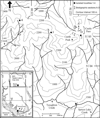
The Taseko Lakes area has yielded the best preserved and most diverse collection of late Hettangian ammonites yet discovered in British Columbia (BC). Early studies of the fauna were undertaken by Frebold (1951, 1967). At that time, eastern Pacific ammonite faunas were poorly understood and species were frequently shoehorned into established north‐west European taxa. 

Since then, knowledge of eastern Pacific Hettangian ammonite faunas has improved considerably. 

Detailed systematic studies have been completed on faunas from localities in other areas of BC, Alberta, Alaska, Oregon, Nevada, Mexico and South America (e.g. Guex 1980, 1995; Imlay 1981; Hillebrandt 1981, 1988, 1990, 1994, 2000a–d; Smith and Tipper 1986; Riccardi et al. 1991; Jakobs and Pálfy 1994; Pálfy et al. 1994, 1999; Taylor 1998; Hall et al. 2000; Taylor and Guex 2002; Hall and Pitaru 2004). 

These studies have demonstrated that Early Jurassic eastern Pacific ammonites had strong Tethyan affinities as well as a high degree of endemism (Guex 1980, 1995; Taylor et al. 1984; Smith et al. 1988; Jakobs et al. 1994; Pálfy et al. 1994). Frebold’s early studies were also hampered because they were based on small collections, which limited understanding of the diversity of the fauna and variation within populations. However, recent mapping has greatly improved our understanding of the geology of Taseko Lakes (Schiarizza et al. 1997; Smith et al. 1998; Umhoefer and Tipper 1998) and encouraged further collecting that has dramatically increased the size of the sample.

A study of the ammonite fauna from Taseko Lakes is of interest for several reasons. The data are important for increasing the precision of the late Hettangian portion of the North American Zonation. 

Owing to the principally Tethyan or endemic nature of Early Jurassic ammonites in the eastern Pacific, a separate zonation for the Hettangian and Sinemurian of the Western Cordillera of North America has been established by Taylor et al. (2001). Except for information available from the early studies by Frebold (1951, 1967), the only Taseko Lakes taxa included in the North American Zonation of Taylor et al. (2001) were species of Angulaticeras studied by Smith and Tipper (2000). 

Since then, Longridge et al. (2006) made significant changes to the zonation of the late Hettangian and early Sinemurian based on a detailed study of the Badouxia fauna from Taseko Lakes (Text‐fig. 2). An additional taxonomic study was recently completed on the late Hettangian ammonite Sunrisites (Longridge et al. 2008) and this information has not yet been included within the zonation. 

Hettangian Zonation
The systematics of the remaining ammonite fauna from Taseko Lakes are presented here. A comprehensive study of this material is important because the exceptional quality and diversity of the fauna provide important data for updating the North American Zonation, making it more comprehensive and more widely applicable, especially in Canada.

The Taseko Lakes fauna can improve Hettangian correlations within North America as well as between North America and the rest of the world. 

North‐west European ammonite successions (e.g. Dean et al. 1961; Mouterde and Corna 1997; Page 2003) are considered the primary standard for Early Jurassic biochronology (Callomon 1984). 

In north‐west Europe, the turnover from schlotheimiid dominated faunas in the late Hettangian to arietitid dominated faunas in the early Sinemurian was sharp (e.g. Dean et al. 1961; Bloos 1994; Bloos and Page 2002). In other areas, by contrast, these faunas were not so mutually exclusive and the transition was much more gradual. 

This makes correlations between north‐west Europe and other areas difficult (e.g. Bloos 1994; Bloos and Page 2000, 2002). Correlations are further impeded by endemism and provincialism. 

The Taseko Lakes fauna addresses these problems because it contains many taxa that are common throughout the eastern Pacific as well as several cosmopolitan taxa that make intercontinental correlation possible. Correlation between North America and other areas is of particular significance in that the interbedded volcanic and fossiliferous marine rocks in North America permit the calibration of geochronological and biochronological time scales (Pálfy et al. 1999, 2000). 

This correlation between the late Hettangian fauna in the Taseko Lakes area and contemporaneous faunas in other areas of North America, South America, New Zealand, western and eastern Tethys, and north‐west Europe is of particular interest to me — especially the correlation of the faunal sequences of Nevada, USA. 

Reference: PaleoDB 157367 M. Clapham GSC C-208992, Section A 09, Castle Pass Angulata - Jurassic 1 - Canada, Longridge et al. (2008)

L. M. Longridge, P. L. Smith, and H. W. Tipper. 2008. Late Hettangian (Early Jurassic) ammonites from Taseko Lakes, British Columbia, Canada. Palaeontology 51:367-404

PaleoDB taxon number: 297415; Cephalopoda - Ammonoidea - Juraphyllitidae; Fergusonites hendersonae Longridge et al. 2008 (ammonite); Average measurements (in mm): shell width 9.88, shell diameter 28.2; Age range: 201.6 to 196.5 Ma. Locality info: British Columbia, Canada (51.1° N, 123.0° W: paleo coordinates 22.1° N, 66.1° W)

Photo One: Hettangian Ammonites and Gastropods, Taseko Lakes. Photo Two: Fergusonites hendersonae, a Late Hettangian (Early Jurassic) ammonite from the Taseko Lakes area of British Columbia, Canadian Rockies, named by Dr. Louise Longridge after Heidi Henderson, Chair, Vancouver Paleontological Society who collected and subsequently donated many Hettangian specimens from Taseko Lakes to the GSC collections. Holotype. GSC 127423 from the Rursicostatum Zone, Castle Pass section A, level 06, Taseko Lakes.

Map: Localities of sections and isolated outcrops bearing late Hettangian ammonites in the Taseko Lakes map area. Figure Two: Zonation for the Hettangian showing correlation of North American zones with South America, north‐west Europe, western Tethys (circum‐Mediterranean), eastern Tethys and New Zealand. Only approximate correlations are implied. 

Saturday 2 March 2024

GIANT GROUND SLOTH: MASSIVE, EXTINCT VEGANS

In 1788, this magnificent specimen of a Megatherium sloth was sent to the Royal Cabinet of Natural History from the Viceroyalty of Rio de la Plata.

The megatheria were large terrestrial sloths belonging to the group, Xenarthra. These herbivores inhabited large areas of land on the American continent. Their powerful skeleton enabled them to stand on their hind legs to reach leaves high in the trees, a huge advantage given the calories needed to be consumed each day to maintain their large size.

Avocados were one of the food preferences of our dear Giant ground sloths. They ate then pooped them out, spreading the pits far and wide. The next time you enjoy avocado toast, thank this large beastie. One of his ancestors may have had a hand (or butt) in your meal.

In 1788, Bru assembled the skeleton as you see it here. It is exhibited at the Museo Nacional De Ciencias Naturales in Madrid, Spain, in its original configuration for historic value. If you look closely, you'll see it is not anatomically correct. But all good paleontology is teamwork. Based upon the drawings of Juan Bautista Bru, George Cuvier used this specimen to describe the species for the very first time.

LOVE CAN TRAVEL ANYWHERE IN AN INSTANT

Nunatsiarmiut Mother and Child, Baffin Island, Nunavut
Warm light bathes this lovely Nunatsiarmiut mother and child from Baffin Island, Nunavut. 

They speak Inuktitut, the mother tongue of the majority of the Nunatsiarmiut who call Baffin Island home. 

Baffin is the largest island in the Arctic Archipelago in the territory of Nunavut in Canada's far north—the chilliest region of Turtle Island. 

As part of the Qikiqtaaluk Region of Nunavut, Baffin Island is home to a constellation of remote Inuit communities each with a deep cultural connection to the land—Iqaluit, Pond Inlet, Pangnirtung, Clyde River, Arctic Bay, Kimmirut and Nanisivik. 

The ratio of Inuit to non-Inuit here is roughly three to one and perhaps the reason why the Inuktitut language has remained intact and serves as the mother tongue for more than 36,000 residents. Inuktitut has several subdialects—these, along with a myriad of other languages—are spoken across the north.  

If you look at the helpful visual below you begin to get a feel for the diversity of these many tongues. The languages vary by region. There is the Iñupiaq of the Inupiatun/Inupiat; Inuvialuktun of the Inuinnaqtun, Natsilingmiutut, Kivallirmiutut, Aivilingmiutut, Qikiqtaaluk Uannanganii and Siglitun. Kalaallisut is spoken by many Greenlandic peoples though, in northwest Greenland, Inuktun is the language of the Inughuit.

We use the word Inuktitut when referring to a specific dialect and inuktut when referring to all the dialects of Inuktitut and Inuinnaqtun.

Northern Language Map (Click to Enlarge)
Should you travel to the serene glacier-capped wilds and rolling tundra of our far north, you will want to dress for the weather and learn a few of the basics to put your best mukluk shod feet forward. 

The word for hello or welcome in Inuktitut is Atelihai—pronounced ahh-tee-lee-hi. And thank you is nakurmiik, pronounced na-kur-MIIK.  

Perhaps my favourite Inuktitut expression is Naglingniq qaikautigijunnaqtuq maannakautigi, pronounced NAG-ling-niq QAI-kau-ti-gi-jun-naqtuq MAAN-na-KAU-ti-gi. This tongue-twister is well worth the linguistic challenge as it translates to love can travel anywhere in an instant. Indeed it can. 

So much of our Indigenous culture is passed through stories, so language takes on special meaning in that context. It is true for all societies but especially true for the Inuit. Stories help connect the past to the present and future. They teach how to behave in society, engage with the world and how to survive in the environment. They also help to create a sense of belonging. 

You have likely seen or heard the word Eskimo used in older books to refer to the Inuit, Iñupiat, Kalaallit or Yupik. This misnomer is a colonial term derived from the Montagnais or Innu word ayas̆kimewnetter of snowshoes

It is a bit like meeting a whole new group of people who happen to wear shoes and referring to them all as cobblers—not as a nickname, but as a legal term to describe populations from diverse communities disregarding the way each self-refer. 

Inukshuk / Inuksuk Marker Cairn
For those who identify as Inupiaq or Yupik, the preferred term is Inuit meaning people—though some lingering use of the term Eskimo lives on. The Inuit as a group are made up of many smaller groups. 

The Inuit of Greenland self-refer as Kalaallit or Greenlanders when speaking Kalaallisut

The Tunumiit of Tunu (east Greenland), speak Tunumiit oraasiat ("East Greenlandic"); and the Inughuit of north Greenland, speak Inuktun "Polar Eskimo."

The Inupiat of Alaska, or real people, use Yupik as the singular for real person and yuk to simply mean person.

When taken all together, Inuit is used to mean all the peoples in reference to the Inuit, Iñupiat, Kalaallit and Yupik. Inuit is the plural of inuk or person

You likely recognize this word from inuksuk or inukshuk, pronounced ih-nook-suuk — the human-shaped stone cairns built by the Inuit, Iñupiat, Kalaallit, Yupik, and other peoples of the Arctic regions of northern Canada, Greenland, and Alaska—as helpful reference markers for hunters and navigation. 

The word inuksuk means that which acts in the capacity of a human, combining inuk or person and suk, as a human substitute

A World of Confusion

You may be disappointed to learn that our northern friends do not live in igloos. I remember answering the phone as a child and the fellow calling was hoping to speak to my parents about some wonderful new invention perfect for use in an igloo. 

The call came while I was in the kitchen of our family home in Port Hardy. He was disappointed to hear that I was standing in a wooden house with the standard four walls to a room and a handy roof topping it off. 

I also had my own room with Scooby-Doo wallpaper, but he was having nothing of it.

"Well, what about your neighbours? Surely, a few of them live in igloos..." 

It seems that some atlases in circulation at the time, and certainly the one he was looking at, simply blanketed everything north of the 49th parallel in a snowy white. His clearly showed an igloo sitting proudly in the centre of the province.

My cousin Shawn brought one such simplified book back from his elementary school in California. British Columbia had a nice image of a grizzly bear and a wee bit further up, a polar bear grinned smugly. 

British Columbia's beaver population would be sad to know that they did not inhabit the province though there were two chipper beavers with big bright smiles—one in Ontario and another gracing the province of Quebec. Further north, where folk do build igloos, their icy domes were curiously lacking. 

Igloos are used for winter hunting trips much the same way we use tents for camping. The Inuit do not have fifty words for snow—you can thank the ethnographer Franz Boas for that wee fabrication—but within the collective languages of the frozen north there are more than fifty words to describe it. And kisses are not nose-to-nose. To give a tender kiss or kunik to a loved one, you press your nose and upper lip to their forehead or cheek and rub gently. 

Fancy trying a wee bit of Inuktitut yourself? This link will bring you to a great place to start: https://inhabitmedia.com/inuitnipingit/

Inuit Language Map:  By Noahedits - Own work, CC BY-SA 4.0. If you want to the image full size, head to this link: https://commons.wikimedia.org/w/index.php?curid=85587388

THE GREAT BEARS OF CANADA

Look at how this protective mamma bear holds her cub in her arms to give him a bit of a wash. 

Her gentle maternal care is truly touching. This mamma has spent late Autumn to Spring in a cave, having birthed them while still hibernation and staying in the den to feed them on her milk.

Black bear cubs stay with their mamma for the first one to three years of their lives while she protects them and teaches them how to thrive in the wild using their keen sense of smell, hearing, vision and strength. Once they are old enough, they will head off into the forest to live solo until they are ready to mate and start a family of their own. 

Mating is a summer affair with bears socializing shoulder to shoulder with potential mates. Once they have mated, black bears head off on their own again to forage and put on weight for their winter hibernation. If the black bear lives in the northern extent of their range, hibernation lasts longer — they will stay in their dens for seven to eight months longer than their southern counterparts. For those that enjoy the warmer climes in the south, hibernation is shorter. If food is available year-round, the bears do not hibernate at all.

The American black bear, Ursus americanus, is native to North America and found in Canada and the United States. 

They are the most common and widely distributed of the three bear species found in Canada. 

There are roughly 650,000 roaming our forests, swamps and streams — meaning there is a good chance of running into them if you spend any amount of time in the wild. 

Full-grown, these fuzzy monkeys will be able to run 48 kilometres (30 miles)  an hour and smell food up to 32 kilometres (20 miles) away.

With their excellent hearing, black bears usually know you are near well before you realize the same and generally take care to avoid you. Those that come in contact with humans often tend to want to check our garbage and hiking supplies for tasty snacks — hey, a free meal is a free meal.    

In British Columbia, we share our province with nearly half of all black bears and grizzly bears that reside in Canada. The 120,000 - 150,000 black bears who live in the province keep our Conservation Officers busy. They account for 14,000 - 25,000 of the calls the service receives each year. Most of those calls centre around their curiosity for the tasty smells emanating from our garbage. They are omnivores with vegetation making up 80-85% of their diet, but they are flexible around that — berries and seeds, salmon or Doritos — bears eat it all. 

And, as with all wild animals, diet is regional. In Labrador, the local black bear population lives mostly on caribou, rodents and voles. In the Pacific Northwest, salmon and other fish form a large part of the protein in their diet versus the bees, yellow jackets and honey others prefer. The braver of their number have been known to hunt elk, deer and moose calves — and a few showy bears have taken on adults of these large mammals. 

Bears hold a special place within our culture and in First Nation mythology in particular — celebrated in art, dance and song. In the Kwak'wala language of the Kwakiutl First Nations of the Pacific Northwest, the word for black bear is t̕ła'yimother is a̱bas and łaxwa̱lap̓a means to love each other

Kermode or Spirit Bear, Ursus americanus kermodei
From the photos here you can see that black bears are not always black —  ranging in colour from cinnamon to brown, tan, blonde, red — and even white. 

The Kermode or Spirit Bear, Ursus americanus kermodei, a subspecies of black bear found only in British Columbia — and our official provincial mammal — is a distinctive creamy white. 

They are not albinos, their colouring stems from a recessive mutant gene — meaning that if they receive two copies it triggers a single, nonsynonymous nucleotide substitution that halts all melanin production. Well, not all. They have pigmented eyes and skin but no colour in their fur. The white colour is an advantage when you are hunting salmon by day. Salmon will shy away from their black cousins knowing their intention is to enjoy them as a tasty snack. 

Spirit Bears live in the Great Bear Rainforest on British Columbia's north and central coast alongside the Kitasoo/Xai’xais First Nation who call the Kermode moskgm’ol or white bear.

The Kitasoo/Xai’xais have a legend that tells of Goo-wee, Raven making one in every ten black bears white to remind us of the time glaciers blanketed the land then slowly retreated — their thaw giving rise to the bounty we harvest today.  

Black bears of any colour are a wee bit smaller than their brown bear or grizzly bear cousins, with males weighing in at 45 to 400 kilograms (100 to 900 pounds) and females ranging from 38 to 225 kilograms (85 to 500 pounds). 

Small by relative standards but still very large animals. And they are long-lived or at least can be. Bears in captivity can live up to 30 years but those who dwell in our forests tend to live half as long or less from a mixture of local hazards and humans. 

Reference: Wild Safe BC: https://wildsafebc.com/species/black-bear/


Wednesday 28 February 2024

FOLKSTONE GAULT CLAY AMMONITES

This lovely wee 2.6 cm ammonite is Anahoplites planns from the Cretaceous Folkstone Gault Clay, county of Kent, southeast England. Joining him on this bit of matrix is a 3.2 cm section of Hamites sp

This matrix you see here is the Gault Clay, known locally as the Blue Slipper. This fine muddy clay was deposited 105-110 million years ago during the Lower Cretaceous (Upper and Middle Albian) in a calm, fairly deep-water continental shelf that covered what is now southern England and northern France.

Lack of brackish or freshwater fossils indicates that the gault was laid down in open marine environments away from estuaries. The maximum depth of the Gault is estimated 40-60m a figure which has been reached by the presence of Borings made by specialist Algal-grazing gastropods and supported by a study made by Khan in 1950 using Foraminifera. Estimates of the surface water temperatures in the Gault are between 20-22°c and 17-19°c on the seafloor. These estimates have been reached by bulk analysis of sediments which probably register the sea surface temperature for calcareous nanofossils.

It is responsible for many of the major landslides around Ventnor and Blackgang the Gault is famous for its diverse fossils, mainly from mainland sites such as Folkestone in Kent.

Folkestone, Kent is the type locality for the Gault clay yielding an abundance of ammonites, the same cannot be said for the Isle of Wight Gault, however, the south-east coast of the island has proved to be fossiliferous in a variety of ammonites, in particular, the Genus Hoplites, Paranahoplites and Beudanticeras.

While the Gault is less fossiliferous here on the island it can still produce lovely marine fossils, mainly ammonites and fish remains from these muddy mid-Cretaceous seas. The Gault clay marine fossils include the ammonites (such as Hoplites, Hamites, Euhoplites, Anahoplites, and Dimorphoplites), belemnites (such as Neohibolites), bivalves (notably Birostrina and Pectinucula), gastropods (including the lovely Anchura), solitary corals, fish remains (including shark teeth), scattered crinoid remains, and crustaceans (look for the crab Notopocorystes).

Occasional fragments of fossil wood may also be found. The lovely ammonite you see here is from the Gault Clays of Folkstone. Not all who name her would split the genus Euhoplites. There’s a reasonable argument for viewing this beauty as a very thick form of E. loricatus with Proeuhoplites being a synonym of Euhoplites

Jack Wonfor shared a wealth of information on the Gault and has many lovely examples of the ammonites found here in his collections. If you wish to know more about the Gault clay a publication by the Palaeontological Association called 'Fossils of the Gault clay' by Andrew S. Gale is available in Dinosaur Isle's gift shop.

There is a very good website maintained by Fred Clouter you can look at for reference. It also contains many handy links to some of the best fossil books on the Gault Clay and Folkstone Fossil Beds. Check it out here: http://www.gaultammonite.co.uk/

Tuesday 27 February 2024

CIBELELLA CORONATA

Cibelella Coronata / Photo: Alexei Molchanov
A spectacular creamy toned specimen of the trilobite Cibelella Coronata striking a very animated pose. 

The Genal spines give this fellow a bit of a starship look as though taking off in flight. 

This beauty is from upper Ordovician deposits along the Neva River at the head of the Gulf of Finland on the Baltic Coast, Saint Petersburg, Russia.


Monday 26 February 2024

FOSSIL FISHAPODS OF NUNAVUT

Qikiqtania wakei, a fishapod & relative to tetrapods
You will likely recall the amazing tetrapodomorpha fossil found on Ellesmere Island in the Canadian Arctic in 2004, Tiktaalik roseae

These were advanced forms transitional between fish and the early labyrinthodonts playfully referred to as fishapods — half-fish, half-tetrapod in appearance and limb morphology. 

Up to that point, the relationship of limbed vertebrates (tetrapods) to lobe-finned fish (sarcopterygians) was well known, but the origin of significant tetrapod features remained obscure for the lack of fossils that document the sequence of evolutionary changes — until Tiktaalik

While Tiktaalik is technically a fish, this fellow is as far from fish-like as you can be and still be a card-carrying member of the group. 

Interestingly, while Neil Shubin and crew were combing the icy tundra for Tiktaalik, another group was trying their luck just a few kilometres away. 

A week before the eureka moment of Tiktaalik's discovery, Tom Stewart and Justin Lemberg unearthed material that we now know to be a relative of Tiktaalik's. 

Meet Qikiqtania wakei, a fishapod and close relative to our dear tetrapods — and cousin to Tiktaalik — who shares features in the flattened triangular skull, shoulders and elbows in the fin. 

Qikiqtania (pronounced kick-kick-TAN-ee-ya)
But, and here’s the amazing part, its upper arm bone (humerus) is specialised for open water swimming, not walking. 

The story gets wilder when we look at Qikiqtania’s position on the evolutionary tree— all the features for this type of swimming are newly evolved, not primitive. 

This means that Qikiqtania secondarily reentered open water habitats from ancestors that had already had some aspect of walking behaviour. 

And, this whole story was playing out 365 million years ago — the transition from water to land was going both ways in the Devonian.

Why is this exciting? You and I descend from those early tetrapods. We share the legacy of their water-to-land transition and the wee bony bits in their wrists and paddles that evolved to become our hands. I know, mindblowing!

Thomas Stewart and Justin Lemberg put in thousands of hours bringing Qikiqtania to life. 

The analysis consisted of a long path of wild events— from a haphazard moment when it was first spotted, a random collection of a block that ended up containing an articulated fin, to a serendipitous discovery three days before Covid lockdowns in March 2020.

Both teams acknowledge the profound debt owed to the individuals, organizations and indigenous communities where they had the privilege to work — Grise Fiord and Resolute Bay— Ellesmere Island in Nunavut, the largest and northernmost territory of Canada. 

Part of that debt is honoured in the name chosen for this new miraculous species. 

Aerial View of Ellesmere Island
The generic name, Qikiqtania (pronounced kick-kick-TAN-ee-ya), is derived from the Inuktitut words Qikiqtaaluk and Qikiqtani which are the traditional place name of the region where the fossil was discovered. 

The specific name, wakei, is in memory of the evolutionary biologist David Wake — colleague, mentor and friend. 

He was a professor of integrative biology and Director and curator of herpetology at the Museum of Vertebrate Zoology at the University of California, Berkeley who passed away in April 2021. 

Wake is known for his work on the biology and evolution of salamanders and vertebrate evolutionary biology. 

If you look at the photo on the left you can imagine visiting these fossil localities in Canada's far north.

Qikiqtania was found on Inuit land and belongs to the community. Thomas Stewart and his colleagues were able to conduct this research because of the generosity and support of individuals in the hamlets of Resolute Bay and Grise Fiord, the Iviq Hunters and Trappers of Grise Fiord, and the Department of Heritage and Culture, Nunavut.

To them, on behalf of the larger scientific community — Nakurmiik. Thank you! 

Here is the link to Tom Stewart's article in The Conversation & paper in Nature that dropped yesterday:

  1. Stewart, Thomas A.; Lemberg, Justin B.; Daly, Ailis; Daeschler, Edward B.; Shubin, Neil H. (2022-07-20). "A new elpistostegalian from the Late Devonian of the Canadian Arctic". Naturedoi:10.1038/s41586-022-04990-wISSN 0028-0836.
  2. Stewart, Thomas. "Meet Qikiqtania, a fossil fish with the good sense to stay in the water while others ventured onto land" The Conversation. Retrieved 2022-07-20.

Image One: An artist’s vision of Qikiqtania enjoying its fully aquatic, free-swimming lifestyle. Alex Boersma, CC BY-ND

Image Two: A new elpistostegalian from the Late Devonian of the Canadian Arctic, T. A. Stewart, J. B. Lemberg, A. Daly, E. B. Daeschler, & N. H. Shubin.

A huge shout out to the deeply awesome Neil Shubin who shared that the paper had been published and offered his insights on what played out behind the scenes!