Showing posts with label HISTORY. Show all posts

Monday, 23 October 2023

KWAGUL INTO THE MIST: ANISALAGA

Kwagu'ł  into the Mist
Kwagu'ł  into the Mist. This painting shows the  Cadwallader Chilkat woven by Anisalaga (Mary Ebbets Hunt) for her daughter Jane Charity Hunt (Born 1873). She is the little sister to William Hunt through whose line I descend.

Jane married Harry Tennyson Cadwallader (1874-1932). Together, they had three daughters, Francis, Edna Leonora, and Annie Beatrice; and four sons, Clarence Chester (Nick), Walter, Calvin, Robert Stephen Eugene and William Isaac. 

Their son William Isaac married Bernice Crystal Spencer. It was their son George Allan (Dusty) Cadwallader who inherited the blanket and eventually donated it to the Museum of Anthropology at the University of British Columbia, Vancouver, British Columbia, Canada. 

The Chilkat has taken a new name as MOA ID Number: A17007. It was last danced at the Isaac Family Potlach in Alert Bay, 'Ya̱lis, in May 2018 & will be danced again. I got to spend some time with the Chilkat to do studies this past year. This piece is the result.

​The mist is the unknown, the veils that lift as we take our steps forward. The figure you see is at once my Grandma Betty and also Jane Charity.

It is an invitation to walk with our ancestors, hi'helus, into a future of possibility.

Anisalaga, The All-Mother
Anisalaga / Anis'laga / Ansnaq / Anain / Anéin / A'naeesla'ga / Mary (Ebbets) Hunt held many names. Her given Kwak'wala name was Musgemxàala. 

She belonged to the Raven/Yéil phratry of the Gigalgam Kyinanuk Tlingit of Tongass. Anisalaga is the blood that binds all the Hunts, Hendersons and more than 1,200 cousins on the West Coast of British Columbia. 

Anisalaga was a descendant of the Head-Chief of Wrangell (Anisalaga's father's father) and Chief Shaawatshook'u Eesh Keishíshk' Shakes IV (her mother's father), whose wife was S’eitlin II, a Deisheetaan of the Raven moiety whose principal crest is the Beaver/S'igeidí, Gaanax.ádi Drifted Ashore House, Xutsnoowú (a.k.a. Xudzidaa) Ḵwáan, Brown Bear Fort (Burnt Wood Tribe) of the Hootchenoo from Aangóon which roughly translates in Łingít to "isthmus town" of Admiralty Island, Lingit Anni, Alaska.

Anisalaga's mother was Aanseet, Chief-of-All-Women, Drifted Ashore House and Chief Ebbets Andáa Neakoot/Nenkoot, Teikweidi Shaanax Hit, Valley House, Taanta Kwaan, was her father.

The Chief Ebbets Pole (the Dogfish Kootéeyaa Pole) was erected in 1892 in Old Tongass Village for her father then moved, re-carved and re-painted at Saxman Totem Park in 1938. An RFP went out in early 2022 to have this pole re-carved. 

​Anisalaga's mother, Aanseet drowned on the Nass River in 1870. Two memorial poles were raised in her honour — one in Old Tongass Village, Alaska, Princess-Shining-Copper (that was stolen and taken to Seattle to stand in Pioneer Square) and one in Tsaxis, Fort Rupert, raised by Anisalaga to overlook Beaver Harbour.

I grew up a few hundred feet away, just up the hill and less than 20 steps from Anisalaga's grave. My father (through whom I get my Tlingit Kwakiutl blood) moved my Norwegian mother here when they left the float camps up the coast. I lived in Fort Rupert and later moved to M&B subdivision in Port Hardy. My strongest memories from childhood are playing on the beach and hillside with my sister—walking in our ancestor's footsteps.

 Anisalaga's childhood would have been much harder. She had five siblings, Yaashút' (her brother who died in 1876), her sister Gaachnéin married Kucheesh III, her sister Abbie (Atk'géigee) married W. H. Bond, her brother Keenanúk married Xanséek and her sister Kéilsháawat married Xaashgáaksh II.

At the time of her birth in 1823, life was very different in Tongass, Lingit Anni, now Alaska. The Russians still controlled much of the coast and had not yet negotiated its sale to the USA.

Anisalaga was a skilled weaver from a long line of Chilkat master weavers — some originally Tsimshian of Wrangel now family through marriage. When she was fourteen, she was put in seclusion according to Lingit tradition. A painter was engaged to create a Naaxein pattern board behind where she worked. A female elder described the figures as Anisalaga wove them into her own Naaxein/naaxiin. 

They might be a Raven/Yéil with a pronounced beak, paired on each side, the Killer Whale/Dakl'aweidi/Kéet underneath and a Grizzly-Bear/Xóots in the centre with faces of other bears to illustrate the Bear Mother story or include other designs — but always with a central family crest figure showcased for when the robe was danced.

​She was taught to prepare all of the materials for weaving — gathering cedar bark, gathering and dyeing of mountain goat wool with bark, lignite, wolf moss Evernia vulpina and copper.

Over the years, she grew famous for her Chilkat weavings — an art the evokes the smell of smoke, the beating of the drum, the shared singsong voices of the Winter dances. She guarded her Chilkat learnings closely but shared with family. She worked in yellow, turquoise, black and white — including an abstract design in the bottom corner that is her kwéiy/signature.

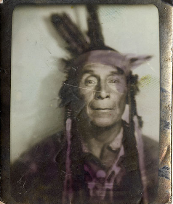
​Her Chilkat weaving, now famous, were photographed by Edward Curtis and Franz Boas, the father of ethnography, who worked with her and her children, particularly her first son George Hunt.

Anisalaga married Robert Hunt at Fort Simpson at Lax-Kw'alaams on the Nass River. They lived in the north then relocated to Fort Rupert where they had eleven children — seven daughters and four sons. Mary wove a Naaxein Chilkat blanket for each of their children. Their second son, William, married Annie Wilson, Kwakiutl, Smoke of the World, and together they had (Robert) Vivian Hunt, my great grandfather. The Chilkat you see my grandmother Betty dancing comes from William to Vivian to her. It's sister blanket woven for Jane Charity is held in collections at the Museum of Anthropology in Vancouver. 

​Anisalaga brought Tlingit songs, stories and the Chilkat weaving tradition from the north to the coast. Through the Ravens of Tongass, her marriage and move to Fort Rupert she brought Kyinanuk totem pole carving traditions to both Tsaxis, Fort Rupert and Namgis First Nation cousins in Alert Bay — influencing the use of the Thunderbird, the Raven, the Sun, Ts'o'noqoa, Sisiutl and Sea Lion.

A replica of Anisalaga's (du tláa/abas) mother's Princess-Shining-Copper Tongass Kootéeyaa 

pole — erected on her mother's grave at Tongass, Lingit Anni, now southern Alaska — was raised in Tsaxis, Fort Rupert as a visual symbol that the Hunt family equally honoured both Tlingit and Kwakwaka'wakw. North and South had found their peace.   

The Hunts you meet on the west coast are her descendants and my family. In 1992, Uncle Hutch Hunt, Auntie Gloria, Uncle Bill Hunt, Irene Hayman, cousins Lily Alfred, Leslie Hunt, Corrine Hunt along with Wayne Alfred Hunt & William Wasden went to Ketchikan to visit Chief Shakes IX, Jonathan DeWitt (Uncle Cookie), younger brother of Charlie DeWitt. They enjoyed a feast at the home of Forestt DeWitt. 

​Many potlatches/ku.éex' have been held to gather the descendants of Anisalaga & Robert Hunt — now more than 1,200 hundred strong. Our beautiful cousins from the north, including Chris Makua and J.K. Samuels and his sister Louise, joined us for those feasts. We held a potlatch and pole raising in 2013 in Tsaxis, Fort Rupert to honour Anisalaga, our All-Mother.  

Tuesday, 12 September 2023

VANCOUVER'S HISTORIC STANLEY PARK

Totem, Welcome & Mortuary Poles at Stanley Park
If you visit Brockton Point in Stanley Park, there are many carved red cedar First Nation poles for you to admire.  

What you are viewing are replicas of First Nation welcome and totem poles that once stood in the park but have been returned to their homes within the province's diverse First Nation communities — or held within museum collections. 

Some of the original totems came from Alert Bay on Cormorant Island, near the Port McNeill on the north coast of Vancouver Island. 

Others came from communities in Haida Gwaii — and still more from the Wuikinuxv First Nations at Rivers Inlet on British Columbia's central west coast — home of the Great Bear Rainforest with her Spirit Bears.

The exception is the most recent addition carved by Robert Yelton in 2009. Robert is a First Nation carver from the Squamish Nation and his original welcome pole graces Brockton Point, the original settlement site of a group of Squamish-Portuguese settlers.  

If you look at the photo above, the lovely chocolate, red and turquoise pole on the right is a replica of the mortuary pole raised to honour the Raven Chief of Skedans or Gida'nsta, the Haida phrase for from his daughter, the title of respect used when addressing a person of high rank. Early fur traders often took the name of the local Chief and used it synonymously as the place names for the sites they visited — hence Skedans from Gida'nsta.

Chief Skedans Mortuary Pole
Chief Skedans, or Qa'gials qe'gawa-i, to his children, lived in Ḵ’uuna Llnagaay, or village at the edge, in Xaayda Kil — a village on the exposed coast of Louise Island — now a Haida Heritage Site.  

There are some paintings you may have seen by Emily Carr of her visits to the site in 1912, She used the phonetic Q'una from Q:o'na to describe both the place name and title of her work. 

Carr's paintings of the totems have always looked to me to be a mash-up — imagine if painter Tamara de Lempicka and photographer Edward Curtis had a baby — not pretty, but interesting.

Some called this area, Huadju-lanas or Xu'adji la'nas, which means Grizzly-Bear-Town, in reference to resident grizzly bear population and their adornment of many totems and artwork by the local artists.

Upon Chief Skedan's death, the mortuary pole was carved both to honour him and provide his final resting place. Dates are a bit fuzzy, but local accounts have this as sometime between 1870-1878 — and at a cost of 290 blankets or roughly $600 in today's currency. 

The great artistry of the pole was much admired by those in the community and those organizing the celebrations for the 1936 Vancouver Golden Jubilee — witnessed by  350,000 newly arrived residents.

Negotiations were pursued and the pole made its way down from Haida Gwaii to Stanley Park in time for the celebrations. The original totem graced Stanley Park for a little over twenty years before eventually making its way back to Haida Gwaii. It was returned to the community with bits of plaster and shoddy paint marring the original. These bits were scraped off and the pole welcomed back with due ceremony. 

In 1964, respected and renowned Northwest Coast master carver, Bill Reid, from the Kaadaas gaah Kiiguwaay, Raven/Wolf Clan of T'anuu, Haida Gwaii and Scottish-German descent, was asked to carve this colourful replica. 

Mountain Goat Detail, Skedans Mortuary Pole
Reid carved the totem onsite in Stanley Park with the help of German carver Werner True. Interestingly, though I looked at length for information on Werner True, all I can find is that he aided Bill Reid on the carving for a payment of $1000.

Don Yeomans, Haida master carver, meticulously recarved the moon crest in 1998. If you have admired the totem pole in the Vancouver Airport, you will have seen some of Yeoman's incredible work. 

The crest is Moon with the face, wings, legs and claws of a mighty and proud Thunderbird with a fairly smallish hooked beak in a split design. We have Moon to thank for the tides and for illuminating our darkest nights. As a crest, Moon is associated with transformation and acts as both guardian and protector.

The original pole had a mortuary box that held the Chief's remains. The crest sits atop a very charming mountain goat. I have included a nice close-up here of the replica for you to enjoy. 

Mountain Goats live in the high peaks of British Columbia and being so close to the sky, they have the supernatural ability to cross over to the sky world. They are also credited as being spirit guardians and guides to First Nation shamans.

I love his horns and tucked-in cloven hooves. There is another pole being carved on Vancouver Island that I hope to see during its creation that also depicts a Mountain Goat. With permission and in time, I hope to share some of those photos with you. 

Mountain Goat is sitting atop Grizzly Bear or Huaji or Xhuwaji’ with little human figures placed in his ears to represent the Chief's daughter and son-in-law, who raised the pole and held a potlatch in his honour. 

Beneath the great bear is Seal or Killer Whale in his grasp. The inscription in the park says it is a Killer Whale but I am not sure about that interpretation — both the look and lore make Seal more likely. Perhaps if Killer Whale were within Thunderbird's grasp — maybe

Though it is always a pleasure to see Killer Whale carved in red cedar, as the first whales came into being when they were carved in wood by a human — or by Raven — then magically infused with the gift of life.

Siwash Rock on the northern end of Third Beach, Stanley Park
The ground these totems sit upon is composed of plutonic, volcanic and sedimentary layers of rock and exhibits the profound influences of glaciation and glacial retreat from the last ice age. 

Glacial deposits sit atop a mix of clay, sand, cobbles and larger boulders of glacial till. 

There are a few areas of exposed volcanics within the park that speak to the scraping of the glaciers as they retreated about 12,500 years ago. 

The iconic moss and lichen-coated Siwash Rock on the northern end of Third Beach is one of the more picturesque of these. It is a basaltic and andesitic volcanic rock — a blend of black phenocrysts of augite cemented together with plagioclase, hornblende and volcanic glass that holds a special place in the oral history of the First Nations of this area. The Squamish First Nation, or Sḵwx̱wú7mesh sníchim, hold the word Slhx̱i7lsh for this rock. 

They tell a story of a man fishing by the shore who was transformed by the spirit-being X̱áays into this iconic rock near the northern end of Third Beach of Stanley Park. At the time, a permanent First Nation settlement was just a short walk away. The man had his fishing gear with him when he was transformed as he had been fishing near the shore. The hole in the rock is not from the erosion of the tides but the cubby hole where Slhx̱i7lsh, now a rocky sentinel, kept his fishing tackle. And as you know, fishing tackle is valuable. One does not simply throw it away simply because you have been turned to stone.

Images not shown: 

Do check out the work of Emily Carr and her paintings of Q:o'na from the 1940s. I'll share a link here but do not have permission to post her works. http://www.emilycarr.org/totems/exhibit/haida/ssintro.htm

Tuesday, 4 July 2023

FOSSILS AND FIRST NATIONS HISTORY IN EASTERN CANADA

Elpistostege watsoni

In the late 1930s, our understanding of the transition of fish to tetrapods — and the eventual jump to modern vertebrates — took an unexpected leap forward. The evolutionary a'ha came from a single partial fossil skull found on the shores of a riverbank in Eastern Canada. 

Meet the Stegocephalian, Elpistostege watsoni, an extinct genus of finned tetrapodomorphs that lived during the Late Givetian to Early Frasnian of the Late Devonian — 382 million years ago. 

Elpistostege watsoni — perhaps the sister taxon of all other tetrapods — was first described in 1938 by British palaeontologist and elected Fellow of the Royal Society of London, Thomas Stanley Westoll. Westoll's research interests were wide-ranging. He was a vertebrate palaeontologist and geologist best known for his innovative work on Palaeozoic fishes and their relationships with tetrapods. 

As a specialist in early fish, Westoll was asked to interpret that single partial skull roof discovered at the Escuminac Formation in Quebec, Canada. His findings and subsequent publication named Elpistostege watsoni and helped us to better understand the evolution of fishes to tetrapods — four-limbed vertebrates — one of the most important transformations in vertebrate evolution. 

Hypotheses of tetrapod origins rely heavily on the anatomy of but a few tetrapod-like fish fossils from the Middle and Late Devonian, 393–359 million years ago. These taxa — known as elpistostegalians — include Panderichthys, Elpistostege and Tiktaalik — none of which had yet to reveal the complete skeletal anatomy of the pectoral fin. 

Elpistostege watsoni
None until 2010 that is, when a complete 1.57-metre-long articulated specimen was found and described by Richard Cloutier et al. in 2020. 

The specimen helped us to understand the origin of the vertebrate hand. Stripped from its encasing stone, it revealed a set of paired fins of Elpistostege containing bones homologous to the phalanges (finger bones) of modern tetrapods and is the most basal tetrapodomorph known to possess them. 

Once the phalanges were uncovered, prep work began on the fins. The fins were covered in wee scales and lepidotrichia (fin rays). The work was tiresome, taking more than 2,700 hours of preparation but the results were thrilling. 

Origin of the Vertebrate Hand
We could now clearly see that the skeleton of the pectoral fin has four proximodistal rows of radials — two of which include branched carpals — as well as two distal rows organized as digits and putative digits. 

Despite this skeletal pattern — which represents the most tetrapod-like arrangement of bones found in a pectoral fin to date blurring the line between fish and land vertebrates — the fin retained lepidotrichia (those wee fin rays) distal to the radials. 

This arrangement confirmed an age-old question — showing us for the first time that the origin of phalanges preceded the loss of fin rays, not the other way around.

E. watsoni is very closely related to Tiktaalik roseae found in 2004 in the Canadian Arctic — a tetrapodomorpha species also known as a Choanata. These were advanced forms transitional between fish and the early labyrinthodonts playfully referred to as fishapods — half-fish, half-tetrapod in appearance and limb morphology. 

Up to that point, the relationship of limbed vertebrates (tetrapods) to lobe-finned fish (sarcopterygians) was well known, but the origin of major tetrapod features remained obscure for lack of fossils that document the sequence of evolutionary changes — until Tiktaalik. While Tiktaalik is technically a fish, this fellow is as far from fish-like you can be and still be a card-carrying member of the group. 

Tiktaalik roseae
Complete with scales and gills, this proto-fish lacked the conical head we see in modern fish but had a rather flattened triangular head more like that of a crocodile. 

Tiktaalik had scales on its back and fins with fin webbing but like early land-living animals, it had a distinctive flat head and neck. He was a brawny brute. The shape of his skull and shoulder look part fish and part amphibian.

The watershed moment came as Tiktaalik was prepped. Inside Tiktaalik's fins, we find bones that correspond to the upper arm, forearm and even parts of the wrist — all inside a fin with webbing — remarkable! 

Its fins have thin ray bones for paddling like most fish, but with brawny interior bones that gave Tiktaalik the ability to prop itself up, using his limbs for support. I picture him propped up on one paddle saying, "how you doing?" 

Six years after Tiktaalik was discovered by Neil Shubin and team in the ice-covered tundra of the Canadian Arctic on southern Ellesmere Island, a team working the outcrops at Miguasha on the Gaspé Peninsula discovered the only fully specimen of E. watsoni found to date — greatly increasing our knowledge of this finned tantalizingly transitional tetrapodomorph. 

E. watsoni fossils are rare — this was the fourth specimen collected in over 130 years of hunting. Charmingly, the specimen was right on our doorstop — extracted but a few feet away from the main stairs descending onto the beach of Miguasha National Park. 

L'nu Mi’gmaq First Nations of the Gespe’gewa’gi Region

Miguasha is nestled in the Gaspésie or Gespe’gewa’gi region of Canada — home to the Mi’gmaq First Nations who self-refer as L’nu or Lnu. The word Mi’gmaq or Mi’kmaq means the family or my allies/friends in Mi'kmaw, their native tongue (and soon to be Nova Scotia's provincial first language). They are the people of the sea and the original inhabitants of Atlantic Canada having lived here for more than 10,000 years. 

The L'nu were the first First Nation people to establish contact and trade with European explorers in the 16th and 17th centuries — and perhaps the Norse as early as the turn of the Millenium. Sailing vessels filled with French, British, Scottish, Irish and others arrived one by one to lay claim to the region — settling and fighting over the land. As each group rolled out their machinations of discovery, tensions turned to an all-out war with the British and French going head to head. I'll spare you the sordid details but for everyone caught in the crossfire, it went poorly.

North America Map 1775 (Click to Enlarge)
Cut to 1760, the British tipped the balance with their win at the Battle of the Restigouche, the last naval battle between France and England for possession of the North American continent — Turtle Island. 

The bittersweet British victory sparked the American War of Independence. 

For the next twenty years, the L'nu would witness and become embroiled in yet another war for these lands, their lands — first as bystanders, then as American allies, then intimidated into submission by the British Royal Navy with a show of force by way of a thirty-four gun man-of-war, encouraging L'nu compliance — finally culminating in an end to the hostilities with the 1783 Treaty of Paris. 

The peace accord held no provisions for the L'nu, Métis and First Nations impacted. None of these newcomers was Mi'kmaq — neither friends nor allies.

It was to this area some sixty years later that the newly formed Geological Survey of Canada (GSC) began exploring and mapping the newly formed United Province of Canada. Geologists in the New Brunswick Geology Branch traipsed through the rugged countryside that would become a Canadian province in 1867. 

It was on one of these expeditions that the Miguasha fossil outcrops were discovered. They, too, would transform in time to become Miguasha National Park or Parc de Miguasha, but at first, they were simply the promising sedimentary exposures on the hillside across the water —  a treasure trove of  Late Devonian fauna waiting to be discovered.

In the summer of 1842, Abraham Gesner, New Brunswick’s first Provincial Geologist, crossed the northern part of the region exploring for coal. Well, mostly looking for coal. Gesner also had a keen eye for fossils and his trip to the Gaspé Peninsula came fast on the heels of a jaunt along the rocky beaches of Chignecto Bay at the head of the Bay of Fundy and home to the standing fossil trees of the Joggins Fossil Cliffs. 

Passionate about geology and chemistry, he is perhaps most famous for his invention of the process to distil the combustible hydrocarbon kerosene from coal oil — a subject on which his long walks exploring a budding Canada gave him a great deal of time to consider. We have Gesner to thank for the modern petroleum industry. He filed many patents for clever ways to distil the soft tar-like coal or bitumen still in use today.

He was skilled in a broad range of scientific disciplines — being a geologist, palaeontologist, physician, chemist, anatomist and naturalist — a brass tacks geek to his core. Gesner explored the coal exposures and fossil outcrops across the famed area that witnessed the region become part of England and not France — and no longer L'nu.

Following the Restigouche River in New Brunswick through the Dalhousie region, Gesner navigated through the estuary to reach the southern coast of the Gaspé Peninsula into what would become the southeastern coast of Quebec to get a better look at the cliffs across the water. He was the first geologist to lay eyes on the Escuminac Formation and its fossils.

In his 1843 report to the Geologic Survey, he wrote, “...I found the shore lined with a coarse conglomerate. Farther eastward the rocks are light blue sandstones and shales, containing the remains of vegetables. (...) In these sandstone and shales, I found the remains of fish and a small species of tortoise with fossil foot-marks.”

We now know that this little tortoise was the famous Bothriolepis, an antiarch placoderm fish. It was also the first formal mention of the Miguasha fauna in our scientific literature. Despite the circulation of his report, Gesner’s discovery was all but ignored — the cliffs and their fossil bounty abandoned for decades to come. Geologists like Ells, Foord and Weston, and the research of Whiteaves and Dawson, would eventually follow in Gesner's footsteps.

North America Map 1866 (Click to Enlarge)
Over the past 180 years, this Devonian site has yielded a wonderfully diverse aquatic assemblage from the Age of Fishes — five of the six fossil fish groups associated with the Devonian including exceptionally well-preserved fossil specimens of the lobe-finned fishes. 

This is exciting as it is the lobe-finned fishes — the sarcopterygians — that gave rise to the first four-legged, air-breathing terrestrial vertebrates – the tetrapods. 

Fossil specimens from Miguasha include twenty species of lower vertebrates — anaspids, osteostra-cans, placoderms, acanthodians, actinopterygians and sarcopterygians — plus a limited invertebrate assemblage, along with terrestrial plants, scorpions and millipedes.

Originally interpreted as a freshwater lacustrine environment, recent paleontological, taphonomic, sedimentological and geochemical evidence corroborates a brackish estuarine setting — and definitely not the deep waters of the sea. This is important because the species that gave rise to our land-living animals began life in shallow streams and lakes. It tells us a bit about how our dear Elpistostege watsoni liked to live — preferring to lollygag in cool river waters where seawater mixed with fresh. Not fully freshwater, but a wee bit of salinity to add flavour.  

  • Photos: Elpistostege watsoni (Westoll, 1938 ), Upper Devonian (Frasnian), Escuminac formation, Parc de Miguasha, Baie des Chaleurs, Gaspé, Québec, Canada. John Fam, VanPS
  • Origin of the Vertebrate Hand Illustration, https://www.nature.com/articles/s41586-020-2100-8
  • Tiktaalik Illustration: By Obsidian Soul - Own work, CC BY 4.0, https://commons.wikimedia.org/w/index.php?curid=47401797

References & further reading:

  • From Water to Land: https://www.miguasha.ca/mig-en/the_first_discoveries.php
  • UNESCO Miguasha National Park: https://whc.unesco.org/en/list/686/
  • Office of L'nu Affairs: https://novascotia.ca/abor/aboriginal-people/
  • Cloutier, R., Clement, A.M., Lee, M.S.Y. et al. Elpistostege and the origin of the vertebrate hand. Nature 579, 549–554 (2020). https://doi.org/10.1038/s41586-020-2100-8
  • Daeschler, E. B., Shubin, N. H. & Jenkins, F. A. Jr. A Devonian tetrapod-like fish and the evolution of the tetrapod body plan. Nature 440, 757–763 (2006).
  • Shubin, Neil. Your Inner Fish: A Journey into the 3.5 Billion History of the Human Body.
  • Evidence for European presence in the Americas in AD 1021: https://www.nature.com/articles/s41586-021-03972-8

Saturday, 1 July 2023

FOSSIL FELINES: MISTER MOZART

Mister Mozart
Cats—those purring enigmas who act like they invented gravity and disdain—have been perfecting their aloof charm for tens of millions of years. 

Long before domestic life on the couch, they prowled prehistoric forests and savannas, already masters of stealth.

The feline family tree begins about 25 million years ago with the Proailurus, whose name literally means “first cat.” 

This Miocene-era predator lived in Europe and Asia and probably looked like your housecat—if your housecat could take down small deer. 

Proailurus gave rise to the Pseudaelurus, the cat that would eventually split into two great evolutionary lineages: the big cats (Pantherinae, including lions, tigers, and leopards) and the small cats (Felinae, which include your couch companion, Felis catus), and snuggle bunnies like Mister Mozart you see here.

By the Pleistocene, cats had diversified spectacularly—from the legendary Smilodon, the sabre-toothed showstopper of Ice Age fame, to the lithe wildcats that would one day move into our granaries, charm our ancestors, and domesticate us. 

Yes, evidence suggests that around 10,000 years ago, humans didn’t so much tame cats as cats decided that humans were helpful enough to tolerate. A trend that continues to this day. 

Their fossils—sleek jaws, retractable claws, and the occasional pawprint—tell a story of evolutionary precision. Cats didn’t just evolve; they optimised. Every leap, pounce, and inscrutable stare has been honed by millions of years of predatory perfection.

So when your cat knocks your favourite mug off the counter and looks smug about it, remember: you’re gazing into the eyes of a finely tuned Miocene hunter. Evolution, it seems, has a sense of humour—and a soft spot for whiskers.

Kane & Mozart divving up the best bed spots
Despite centuries of cartoon propaganda suggesting otherwise, cats and dogs can form some of the most endearing interspecies friendships in the animal kingdom. 

While their social codes differ—dogs being pack-oriented and demonstrative, cats favouring solitary stealth and subtlety—mutual respect (and occasionally a shared sunny spot or prime position on your bed) often bridges the divide. 

Studies in animal behaviour show that early socialisation, body language recognition, and individual temperament play key roles in fostering harmony between felines and canines. 

A confident cat and a calm, well-socialised dog are a recipe for peaceful coexistence—and sometimes, genuine affection. Watching a cat gently groom a dog’s ears or a Ridgeback stoically endure a kitten’s playful ambush brings a smile to us all. Evolution may have set them on different paths, but friendship, it seems, is a universal instinct.

Monday, 5 June 2023

EXPLORING THE GLORIOUS KOOTENAY REGION

The East Kootenay region on the south-eastern edge of British Columbia is a land of colossal mountains against a clear blue sky. 

That is not strictly true, of course, as this area does see its fair share of rain and temperature extremes — but visiting in Autumn every view is a postcard of mountainous terrain.

Rocks from deep within the Earth's crust underlie the entire East Kootenay region and are commonly exposed in the areas majestic mountain peaks, craggy rocky cliffs, glaciated river canyons, and rock cuts along the highways. Younger Ice Age sediments blanket much of the underlying rock.

I've been heading to the Cranbrook and Fernie area since the early 1990s. My interest is the local geology and fossil history that these rocks have to tell. I'm also drawn to the warm and welcoming locals who share a love for the land and palaeontological treasures that open a window to our ancient past.  

Cranbrook is the largest community in the region and is steeped in mining history and the opening of the west by the railway. It is also a stone's throw away from Fort Steele and the Lower Cambrian exposures of the Eager Formation. These fossil beds rival the slightly younger Burgess Shale fauna and while less varied, produce wonderful examples of olenellid trilobites and weird and wonderful arthropods half a billion years old. 

Labiostria westriopi, McKay Group
The Lower Cambrian Eager Formation outcrops at a few localities close to Fort Steele, many known since the early 1920s, and up near Mount Grainger near the highway. 

Further east, the Upper Cambrian McKay Group near Tanglefoot Mountain is a palaeontological delight with fifteen known outcrops that have produced some of the best-preserved and varied trilobites in the province — many of them new species. 

The McKay Formation also includes Ordovician outcrops sprinkled in for good measure.

Other cities in the area and the routes to and from them produce other fossil fauna from Kimberley to Fernie and the district municipality of Invermere and Sparwood. This is an arid country with native grasslands and forests of semi-open fir and pine. Throughout there are a host of fossiliferous exposures from Lower Cretaceous plants to brachiopods. 

The area around Whiteswan Lake has wonderful large and showy Ordovician graptolites including Cardiograptus morsus and Pseudoclimacograptus angustifolius elongates — some of our oldest relatives. A drive down to Flathead will bring you to ammonite outcrops and you can even find Eocene fresh-water snails in the region. 

The drive from Cranbrook to Fernie is about an hour and change through the Cambrian into the Devonian which flip-flops and folds over revealing Jurassic exposures. 

Fernie Ichthyosaur Excavation, 1916
The Crowsnest Highway into Fernie follows Mutz Creek. From the highway, you can see the Fernie Group and the site along the Elk River where an ichthyosaur was excavated in 1916. 

The Fernie Formation is Jurassic. It is present in the western part of the Western Canada Sedimentary Basin in western Alberta and northeastern British Columbia. 

It takes its name from the town of Fernie, British Columbia, and was first defined by W.W. Leach in 1914. The town of Fernie is rimmed by rugged mountains tipped with Devonian marine outcrops. In essence, all these mountains are upside down with the oldest layers flipped to the top and a good 180 million years older than those they sit upon. 

Before they were mountains, these sedimentary rocks were formed as sediment collected in a shallow sea or inland basin. About 360 million years ago, the rocks that you see in Fernie today were down near the equator. 

They road tectonic plates, pushing northeast smashing into the coastline of what would become British Columbia. A little push here, shove there — compression and thrust faulting — and the rock was rolled over on its head — repeatedly. But that is how mountains are often formed, though not usually pushed so hard that they flip over. But still, it is a slow, relentless business. 

Cretaceous Plant Material, Fernie, BC
Within Fernie, there are small exposures of Triassic and Jurassic marine outcrops. East of the town there are Cretaceous plant sites, and of course, the Jurassic 1.4-metre Titanites occidentalis ammonite up on Coal Mountain.

The regional district's dominant landform is the Rocky Mountain Trench, which is flanked by the Purcell Mountains and the Rocky Mountains on the east and west, and includes the Columbia Valley region. 

The southern half of which is in the regional district — its northern half is in the Columbia-Shuswap Regional District. 

The regional district of Elk Valley in the southern Rockies is the entryway to the Crowsnest Pass and an important coal-mining area. 

Other than the Columbia and Kootenay Rivers, whose valleys shape the bottomlands of the Rocky Mountain Trench, the regional districts form the northernmost parts of the basins of the Flathead, Moyie and Yahk Rivers. 

The Moyie and Yahk are tributaries of the Kootenay, entering it in the United States, and the Flathead is a tributary of the Clark Fork into Montana.

Photo One: Tyaughton Mountain, Mckay Group; Photo Two: Labiostria westriopi, Upper Cambrian McKay Group, Site ML (1998); John Fam Collection; Photo Three: Ichthyosaur Excavation, Fernie, British Columbia, 1916; Photo Four: Cretaceous Plant Fossils, east of Fernie towards Coal Mountain. The deeply awesome Guy Santucci as hand-model for scale. 

Sunday, 5 February 2023

KI'APALANO: STONE, BONE AND WATER

Cretaceous Plant Material / Three Brothers Formation
Vancouver has a spectacular mix of mountains, forests, lowlands, inlets and rivers all wrapped lovingly by the deep blue of the Salish Sea. 

When we look to the North Shore, the backdrop is made more spectacular by the Coast Mountains with a wee bit of the Cascades tucked in behind.

If you were standing on the top of the Lion's Gate Bridge looking north you would see the Capilano Reservoir is tucked in between the Lions to the west and Mount Seymour to the east on the North Shore. 

The bounty of that reservoir flows directly into your cup. If you look down from the reservoir you see the Capilano River as it makes its way to the sea and enters Burrard Inlet.

The Capilano River on Vancouver's North Shore flows through the Coast Mountains and our coastal rainforest down to the Capilano watershed enroute to Burrard Inlet. The headwaters are at the top of Capilano up near Furry Creek. They flow down through the valley, adding in rainwater, snowmelt and many tributaries before flowing into Capilano Lake. The lake in turn flows through Capilano Canyon and feeds into the Capilano River.

Today, for many, the Capilano River is the clear, cold water with which we fill our cups. But not so long ago, this Kia’palano, this beautiful river, was the entry point to Homulchesan, traditionally called X̱wemelch'stn, whose name means fast-moving water of fish and the domain of Douglas fir trees and the wild sacred salmon who spawn here.

Capilano Watershed & Reservoir
Sacred First Nations Land

This area was once the exclusive domain of the Coast Salish First Nations —  xʷmə?kʷəyəm (Musqueam), Skwxwú7mesh (Squamish), and səlilwətaɬ (Tsleil-Waututh) Nations until the early 1800s. 

The Musqueam First Nation are traditional hən̓q̓əmin̓əm̓ speaking people who number a strong and thriving 1,300. Many live today on a wee slip of their traditional territory just south of Marine Drive near the mouth of the Fraser River. 

The Secwepemc or Shuswap First Nations are a collective of 17 bands occupying the south-central part of British Columbia. Their ancestors have lived in the interior of BC, the Secwepemc territories, for at least 10,000 years.

The Coast Salish First Nations have lived in this region for thousands of years — from the mouth of the Columbia River in Oregon to north of Bute Inlet. They ancestors of those who live here today braved the cold, following the receding of the ice to forge new roots, build villages and strengthen their connections to this land.   
It is to the Squamish Nation that we owe the name of Capilano which is an anglicized version of Kia'palano. 

In Sḵwx̱wú7mesh snichim or Skwxwú7mesh, their spoken language, Kia'palano/Capilano means beautiful river

Chief Kia'palano (c. 1854-1910) was the Chief of the Squamish Nation from 1895-1910 — and Chief of the territory where this beautiful river flows — Sa7plek.
 
The Cleveland Dam — Capilano River Regional Park

Many things have changed since then, including the Capilano River's path, water levels and sediment deposition. For the salmon who used this path to return home and those who depended on them, life has been forever altered by our hands. The Capilano River still runs with Summer Coho, Spring & Summer Steelhead and Autumn Chinook. The small numbers of Spring/Summer Steelhead are maintained through catch and release and may one day reach their former levels of plenty along Vancouver’s North Shore. Elsewhere, we are beginning to see a rewilding of Vancouver with the return of the salmon to our rivers these past few years. 

It is a hopeful recovery from an amazing creature and their will to not just survive but thrive. Marina Dodis, a local film maker has done a wonderful job of recording that rewilding in her film, The Return. I'll pop a link below for you to watch it. I'm sure you'll enjoy it as much as I did.

We have Ernest Albert Cleveland to thank for the loss of that salmon but can credit him with much of our drinking water as it is caught and stored by the dam that bears his name. It was his vision to capture the bounty from the watershed and ensure it made its way into our cups and not the sea. 

Both the water and a good deal of sediment from the Capilano would flow into Burrard Inlet if not held back by the 91-metre concrete walls of the Cleveland Dam. While it was not Ernest's intention, his vision and dam had a secondary impact. In moving the mouth of the Capilano River he altered the erosion pattern of the North Shore and unveiled a Cretaceous Plant Fossil outcrop that is part of the Three Brothers Formation.

Capilano River Canyon & Regional Park
Know Before You Go

The fossil site is easily accessible from Vancouver and best visited in the summer months when water levels are low. 

The level of preservation of the fossils is quite good. The state in which they were fossilized, however, was not ideal. They look to have been preserved as debris that gathered in eddies in a stream or delta.

There are Cretaceous fossils found only in the sandstone. You will see exposed shale in the area but it does not contain fossil material. 

Interesting, but again not fossiliferous, are the many granitic and limestone boulders that look to have been brought down by glaciers from as far away as Texada Island. Cretaceous plant material (and modern material) found here include Poplar (cottonwood)  Populus sp. Bigleaf Maple, Acer machphyllum, Alder, Alnus rubra, Buttercup  Ranvuculus sp., Epilobrium, Red cedar, Blackberry and Sword fern.

Capilano Fossil Field Trip:

From downtown Vancouver, drive north through Stanley Park and over the Lion’s Gate Bridge. Take the North Vancouver exit toward the ferries. Turn right onto Taylor Way and then right again at Clyde Avenue. Look for the Park Royal Hotel. Park anywhere along Clyde Avenue.

From Clyde Avenue walk down the path to your left towards the Capilano River. Watch the water level and tread cautiously as it can be slippery if there has been any recent rain. Look for beds of sandstone about 200 meters north of the private bridge and just south of the Highway bridge. The fossil beds are just below the Whytecliff Apartment high rises. Be mindful of high water and slippery rocks.

Visiting the Capilano Watershed and Reservoir:

Visitors can see the reservoir from Cleveland Dam at the north end of Capilano River Regional Park. You can also visit the Capilano River Hatchery, operated below Cleveland Dam since 1971.

IN THE HEART OF THE CITY, A WILD MIRACLE AWAITS — THE RETURN, a film by the supremely talented Marina Dodis

There is something astonishing happening in the city of Vancouver. Largely unnoticed amidst vehicle traffic, industrial sites and construction, wild salmon are returning to their ancient spawning grounds.

Once an important salmon bearing area, this watershed became severely degraded as the city grew. The run collapsed and was declared “dead”. As salmon are iconic for people in British Columbia, concerned citizens became engaged. The rewilding has begun to pay off. After disappearing for 80 years, people can now witness the autumn spectacle of these powerful swimmers fighting to reach the streams they hatched in. To have a salmon run taking place within city limits is almost completely unique in a metropolis of this size.

Filmed with a quiet, observing lens over many years, "The Return" takes us into hidden enclaves of wilderness within the city, where tiny salmon smolts shimmer beneath the water's surface. Now that they have come back, their future is in our hands.

Link: https://madodis.wixsite.com/the-return?fbclid=IwAR349gFSZtmb3FN4iZRP6AGLyTH0O7MQnQbY-Prup6Qa0ICUzdhaw3vCkSk

Saturday, 4 February 2023

MIGHTY KWIKW: BALD EAGLE

Bald Eagle / Kwikw / Haliaeetus leucocephalus
A mighty Bald Eagle sitting with wings spread looks to be controlling the weather with his will as much as being subject to it. This fellow has just taken a dip for his evening meal and is drying his feathers in the wind. 

As you can imagine, waterlogged feathers make flight difficult. Their wings are built for graceful soaring and gliding on updrafts of warm air called thermals. 

Their long feathers are slotted, easily separating so air flows smoothly and giving them the added benefit of soaring at slower speeds. 

As well as his wings, this fellow is also drying off his white head feathers. A bald eagle's white head can make it look bald from a distance but that is not where the name comes from. It is from the old English word balde, meaning white.

In the Kwak'wala language of the Kwakiutl First Nations of the Pacific Northwest — or Kwakwaka'wakw, speakers of Kwak'wala — an eagle is known as kwikw (kw-ee-kw) and an eagle's nest is called a kwigwat̕si

Should you encounter an eagle and wish to greet them in Kwak'wala, you would just say yo. Yup, just yo. They would like your yo hello better if you offered them some fresh fish. They dine on all sorts of small mammals, fish and birds but are especially fond of pink salmon or ha̱nu'n (han-oon).

These living dinosaurs are a true homage to their lineage. They soar our skies with effortless grace. Agile, violent and beautiful, these highly specialized predators can catch falling prey mid-flight and dive-bomb into rivers to snag delicious salmon. 

Their beauty and agility are millions of years in the making. From their skeletal structure to their blood cells, today’s birds share a surprising evolutionary foundation with reptiles. 

Between 144 million and 66 million years ago, during the Mesozoic era, we see the first birds evolve. Eventually, tens of millions of years ago, an ancient group of birds called kites developed. Like today’s bald eagle, early kites are thought to have scavenged and hunted fish.

About 36 million years ago, the first eagles descended from kites, their smaller cousins. First to appear were the early sea eagles, which — like kites — continued to prey on fish and whose feet were free of feathers, along with booted eagles, which had feathers below the knee. Fossils of Bald Eagles are very rare and date to the late Pleistocene. Eagles are known from the early Pleistocene of Florida, but they are extinct species not closely related to the bald eagle.

Like the kites, bald eagles have featherless feet, but they also developed a range of other impressive adaptations that help them hunt fish and fowl in a watery environment. Each foot has four powerful toes with sharp talons. Tiny projections on the bottom of their feet called “spicules” help bald eagles grasp their prey. A bald eagle also has serrations on the roof of its mouth that help it hold slippery fish, and incredibly, the black pigment in its wing feathers strengthens them against breakage when they dive head first into water.

Obviously, there is much more than their striking white heads that sets these iconic raptors apart from the crowd. Their incredible physiology, built for life near the water, is literally millions of years in the making. 

Friday, 3 February 2023

FOSSILS IN THE LAND OF THE NUU-CHAH-NULTH FIRST NATIONS

Nootka Fossil Field Trip. Photo: John Fam
The rugged west coast of Vancouver Island offers spectacular views of a wild British Columbia. Here the seas heave along the shores slowly eroding the magnificent deposits that often contain fossils. 

Just off the shores of Vancouver Island, east of Gold River and south of Tahsis is the picturesque and remote Nootka Island.

This is the land of the proud and thriving Nuu-chah-nulth First Nations who have lived here always

Always is a long time, but we know from oral history and archaeological evidence that the Mowachaht and Muchalaht peoples lived here, along with many others, for many thousands of years — a time span much like always

While we know this area as Nootka Sound and the land we explore for fossils as Nootka Island, these names stem from a wee misunderstanding. 

Just four years after the 1774 visit by Spanish explorer Juan Pérez — and only a year before the Spanish established a military and fur trading post on the site of Yuquot — the Nuu-chah-nulth met the Englishman, James Cook.  

Captain Cook sailed to the village of Yuquot just west of Vancouver Island to a very warm welcome. He and his crew stayed on for a month of storytelling, trading and ship repairs. Friendly, but not familiar with the local language, he misunderstood the name for both the people and land to be Nootka. In actual fact, Nootka means, go around, go around

Two hundred years later, in 1978, the Nuu-chah-nulth chose the collective term Nuu-chah-nulth — nuučaan̓uł, meaning all along the mountains and sea or along the outside (of Vancouver Island) — to describe themselves. 

It is a term now used to describe several First Nations people living along western Vancouver Island, British Columbia. 

It is similar in a way to the use of the United Kingdom to refer to the lands of England, Scotland and Wales — though using United Kingdom-ers would be odd. Bless the Nuu-chah-nulth for their grace in choosing this collective name.  

An older term for this group of peoples was Aht, which means people in their language and is a component in all the names of their subgroups, and of some locations — Yuquot, Mowachaht, Kyuquot, Opitsaht. While collectively, they are the Nuu-chah-nulth, be interested in their more regional name should you meet them. 

But why does it matter? If you have ever mistakenly referred to someone from New Zealand as an Aussie or someone from Scotland as English, you have likely been schooled by an immediate — sometimes forceful, sometimes gracious — correction of your ways. The best answer to why it matters is because it matters.

Each of the subgroups of the Nuu-chah-nulth viewed their lands and seasonal migration within them (though not outside of them) from a viewpoint of inside and outside. Kla'a or outside is the term for their coastal environment and hilstis for their inside or inland environment.

It is to their kla'a that I was most keen to explore. Here, the lovely Late Eocene and Early Miocene exposures offer up fossil crab, mostly the species Raninid, along with fossil gastropods, bivalves, pine cones and spectacularly — a singular seed pod. These wonderfully preserved specimens are found in concretion along the foreshore where time and tide erode them out each year.

Five years after Spanish explorer Juan Pérez's first visit, the Spanish built and maintained a military post at Yuquot where they tore down the local houses to build their own structures and set up what would become a significant fur trade port for the Northwest Coast — with the local Chief Maquinna's blessing and his warriors acting as middlemen to other First Nations. 

Following reports of Cook's exploration British traders began to use the harbour of Nootka (Friendly Cove) as a base for a promising trade with China in sea-otter pelts but became embroiled with the Spanish who claimed (albeit erroneously) sovereignty over the Pacific Ocean. 

Dan Bowen searching an outcrop. Photo: John Fam
The ensuing Nootka Incident of 1790 nearly led to war between Britain and Spain (over lands neither could actually claim) but talk of war settled and the dispute was settled diplomatically. 

George Vancouver on his subsequent exploration in 1792 circumnavigated the island and charted much of the coastline. His meeting with the Spanish captain Bodega y Quadra at Nootka was friendly but did not accomplish the expected formal ceding of land by the Spanish to the British. 

It resulted however in his vain naming the island "Vancouver and Quadra." The Spanish captain's name was later dropped and given to the island on the east side of Discovery Strait. Again, another vain and unearned title that persists to this day.

Early settlement of the island was carried out mainly under the sponsorship of the Hudson's Bay Company whose lease from the Crown amounted to 7 shillings per year — that's roughly equal to £100.00 or $174 CDN today. Victoria, the capital of British Columbia, was founded in 1843 as Fort Victoria on the southern end of Vancouver Island by the Hudson's Bay Company's Chief Factor, Sir James Douglas. 

With Douglas's help, the Hudson's Bay Company established Fort Rupert on the north end of Vancouver Island in 1849. Both became centres of fur trade and trade between First Nations and solidified the Hudson's Bay Company's trading monopoly in the Pacific Northwest.

The settlement of Fort Victoria on the southern tip of Vancouver Island — handily south of the 49th parallel — greatly aided British negotiators to retain all of the islands when a line was finally set to mark the northern boundary of the United States with the signing of the Oregon Boundary Treaty of 1846. Vancouver Island became a separate British colony in 1858. British Columbia, exclusive of the island, was made a colony in 1858 and in 1866 the two colonies were joined into one — becoming a province of Canada in 1871 with Victoria as the capital.

Dan Bowen, Chair of the Vancouver Island Palaeontological Society (VIPS) did a truly splendid talk on the Fossils of Nootka Sound. With his permission, I have uploaded the talk to the ARCHEA YouTube Channel for all to enjoy. Do take a boo, he is a great presenter. Dan also graciously provided the photos you see here. The last of the photos you see here is from the August 2021 Nootka Fossil Field Trip. Photo: John Fam, Vice-Chair, Vancouver Paleontological Society (VanPS).

Know Before You Go — Nootka Trail

The Nootka Trail passes through the traditional lands of the Mowachaht/Muchalat First Nations who have lived here since always. They share this area with humpback and Gray whales, orcas, seals, sea lions, black bears, wolves, cougars, eagles, ravens, sea birds, river otters, insects and the many colourful intertidal creatures that you'll want to photograph.

This is a remote West Coast wilderness experience. Getting to Nootka Island requires some planning as you'll need to take a seaplane or water taxi to reach the trailhead. The trail takes 4-8 days to cover the 37 km year-round hike. The peak season is July to September. Permits are not required for the hike. 

Access via: Air Nootka floatplane, water taxi, or MV Uchuck III

  • Dan Bowen, VIPS on the Fossils of Nootka: https://youtu.be/rsewBFztxSY
  • https://www.thecanadianencyclopedia.ca/en/article/sir-james-douglas
  • file:///C:/Users/tosca/Downloads/186162-Article%20Text-199217-1-10-20151106.pdf
  • Nootka Trip Planning: https://mbguiding.ca/nootka-trail-nootka-island/#overview


Saturday, 21 January 2023

INDIGO: NATURAL DYES

Natural dyes are dyes or colourants derived from plants, invertebrates, or minerals. The majority of natural dyes are vegetable dyes from plant sources — roots, berries, bark, leaves, and wood — and other biological sources such as fungi and lichens.

Archaeologists have found evidence of textile dyeing dating back to the Neolithic period. In China, dyeing with plants, barks and insects has been traced back more than 5,000 years and looks to be our first attempt at the practice of chemistry.

The essential process of dyeing changed little over time. Typically, the dye material is put in a pot of water and then the textiles to be dyed are added to the pot, which is heated and stirred until the colour is transferred. Sometimes, we use workers with stout marching legs to mix this up.

Traditional dye works still operate in many parts of the world. There is a revival of using natural indigo in modern Egypt — although their indigo dye is mostly imported. The same is true further south in Sudan. They've been importing cloth from Upper Egypt as far back as we have written records and continue the practice of the cloth and dye imports today. Clean white cotton is more the style of western Sudan and Chad, but they still like to throw in a bit of colour.

Traditional Dye Vats
So do the folk living in North Africa. Years ago, I was travelling in Marrakesh and saw many men with noticeably orange, blueish or purplish legs. It wasn't one or two but dozens of men and I'd wondered why this was.

My guide took me to the top of a building so I could look down on rows and rows of coloured vats. In every other one was a man marching in place to work the dye into the wool. Their legs took on the colour from their daily march in place in huge tubs of liquid dye and sheared wool. 

This wool would be considered textile fibre dyed before spinning — dyed in the wool — but most textiles are yarn-dyed or piece-dyed after weaving. In either case, the finished product is quite fetching even if the dyer's legs are less so. 

Many natural dyes require the use of chemicals called mordants to bind the dye to the textile fibres; tannin from oak galls, salt, natural alum, vinegar, and ammonia from stale urine were staples of the early dyers.

Many mordants and some dyes themselves produce strong odours. Urine is a bit stinky. Not surprisingly, large-scale dyeworks were often isolated in their own districts.

Woad, Isatis tinctoria
Plant-based dyes such as Woad, Isatis tinctoria, indigo, saffron, and madder were raised commercially and were important trade goods in the economies of Asia and Europe. 

Across Asia and Africa, patterned fabrics were produced using resist dyeing techniques to control the absorption of colour in piece-dyed cloth.

Dyes such as cochineal and logwood, Haematoxylum campechianum, were brought to Europe by the Spanish treasure fleets, and the dyestuffs of Europe were carried by colonists to America.

Throughout history, people have dyed their textiles using common, locally available materials, but scarce dyestuffs that produced brilliant and permanent colours such as the natural invertebrate dyes. Crimson kermes became highly prized luxury items in the ancient and medieval world. Red, yellow and orange shades were fairly easy to procure as they exist as common colourants of plants. It was blue that people sought most of all and purple even more so.

Indigofera tinctoria, a member of the legume or bean family proved just the trick. This lovely plant —  named by the famous Swedish botanist Carl Linneaus, the father of formalized binomial nomenclature — grows in tropical to temperate Asia and subtropical regions, including parts of Africa.

The plants contain the glycoside indican, a molecule that contains a nitrogenous indoxyl molecule with some glucose playing piggyback. 

Indigo dye is a product of the reaction of indoxyl by a mild oxidizing agent, usually just good old oxygen.

To make the lovely blue and purple dyes, we harvest the plants and ferment them in vats with urine and ash. The fermentation splits off the glucose, a wee bit of oxygen mixes in with the air (with those sturdy legs helping) and we get indigotin — the happy luxury dye of royalty, emperors and kings.

While much of our early dye came from plants — now it is mostly synthesized — other critters played a role. Members of the large and varied taxonomic family of predatory sea snails, marine gastropod mollusks, commonly known as murex snails were harvested by the Phoenicians for the vivid dye known as Tyrian purple.

While the extant specimens maintained their royal lineage for quite some time; at least until we were able to manufacture synthetic dyes, it was their fossil brethren that first captured my attention. There are about 1,200 fossil species in the family Muricidae. 

They first appear in the fossil record during the Aptian of the Cretaceous. Their ornate shells fossilize beautifully. I first read about them in Addicott's Miocene Gastropods and Biostratigraphy of the Kern River Area, California. It is a wonderful survey of 182 early and middle Miocene gastropod taxa.

References:

George E. Radwin and Anthony D'Attilio: The Murex shells of the World, Stanford University press, 1976, ISBN 0-8047-0897-5

Pappalardo P., Rodríguez-Serrano E. & Fernández M. (2014). "Correlated Evolution between Mode of Larval Development and Habitat in Muricid Gastropods". PLoS ONE 9(4): e94104. doi:10.1371/journal.pone.0094104

Miocene Gastropods and Biostratigraphy of the Kern River Area, California; United States Geological Survey Professional Paper 642  

Saturday, 14 January 2023

FOUR TUSKS AND A TRUNK: TETRALOPHODON

Tetralophodon ("four-ridged tooth") is an extinct proboscidean genus belonging to the superfamily Elephantoidea. 

Their fossils have been found from the late Miocene to the Middle Pliocene of Europe, Asia, and Africa, which means many of our ancestors would have had the opportunity to see and hunt them. Lucky for them, these large elephant-like animals preferred fruits and vegetables. 

Like the gomphotheres, to which it was not closely related, Tetralophodon had an impressive four tusks and a trunk. They were big and on size with our modern elephants. You and I would come up to their hip bone on average. They were about 2.58–3.45 m (8.5–11.3 ft) tall at the shoulder and up to 10 tonnes in weight, larger than the size of the present Asian elephant, with a long trunk and incisors ranging up to 2 m (6.6 ft) long. 

Tuesday, 6 December 2022

OYSTER: T'LOX'TLOX

One of the now rare species of oysters in the Pacific Northwest is the Olympia oyster, Ostrea lurida, (Carpenter, 1864).  

While rare today, these are British Columbia’s only native oyster. 

Had you been dining on their brethren in the 1800s or earlier, it would have been this species you were consuming. Middens from Port Hardy to California are built from Ostrea lurida.

These wonderful invertebrates bare their souls with every bite. Have they lived in cold water, deep beneath the sea, protected from the sun's rays and heat? Are they the rough and tumble beach denizens whose thick shells tell us of a life spent withstanding the relentless pounding of the sea? Is the oyster in your mouth thin and slimy having just done the nasty—spurred by the warming waters of Spring? 

Is this oyster a local or was it shipped to your current local and, if asked, would greet you with "Kon'nichiwa?" Not if the beauty on your plate is indeed Ostrea lurida

Oyster in Kwak'wala is t̕łox̱t̕łox̱
We have been cultivating, indeed maximizing the influx of invasive species to the cold waters of the Salish Sea for many years. 

But in the wild waters off the coast of British Columbia is the last natural abundant habitat of the tasty Ostrea lurida in the pristine waters of  Nootka Sound. 

The area is home to the Nuu-chah-nulth First Nations who have consumed this species boiled or steamed for thousands of years. Here these ancient oysters not only survive but thrive — building reefs and providing habitat for crab, anemones and small marine animals. 

Oysters are in the family Ostreidae — the true oysters. Their lineage evolved in the Early Triassic — 251 - 247 million years ago. 

In the Kwak̓wala language of the Kwakiutl or Kwakwaka'wakw, speakers of Kwak'wala, of the Pacific Northwest and my family, an oyster is known as t̕łox̱t̕łox̱

I am curious to learn if any of the Nuu-chah-nulth have a different word for an oyster. If you happen to know, I would be grateful to learn.