Showing posts with label HISTORY. Show all posts

Saturday, 25 December 2021

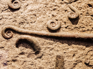
GOD JUL: TRILACINOCERAS NORVEGICUM

Trilacinoceras norvegicum
A lovely example of Trilacinoceras norvegicum (Sweet, 1958), a nektonic carnivorous cephalopod from Ordovician outcrops on Helgö Island, Hovindsholm, Helgøya, Lake Mjosa, Norway.

This has been a site of human habitation for more than 5,000 years. Vikings, kings, traders, farmers —  and geologists have walked these fields.

To give that timeframe a bit of context, that's about the age of Skara Brae, the Neolithic settlement in Orkney, Scotland — and older than Stonehenge which clocks in at 3000 BC to 2000 BC and the Great Pyramids — built around 2560 BC.

For my friend, Gale Bishop, that's about 469 km west or a good 7-hour drive from your ancestral home in Ask, just north of Bergen and just south of Knarvik where many of my relatives live — Hei du!

The fossils found here are part of the Engervik Member, Elnes Formation, Aseri, and date back to the Middle Ordovician, 463.5 - 460.9 million years ago. W. C. Sweet did fossil fieldwork here in the 1950s and published a paper on the Middle Ordovician of the Oslo Region, Norway 10. Nautiloid Cephalopods. Norsk Geologisk Tidsskrift 38:1-178.

Deservedly, Sweetoceras boreale is named for him and is one of the most delightful species names of all time. In the 1960s, Yochelson picked up where Sweet left off, continuing the survey of the Middle Ordovician of the Oslo region. I chose this Trilacinoceras for a holiday post because their curly tops remind me of a wee Norwegian gnome, or Nisse from the Norse niðsi, a dear little relative. My Swedish relatives call them Tomte, a throwback to Saint Birgitta of Sweden in the 1300s.

Helgøya is an island in Mjøsa located in the Ringsaker municipality of Hedmark county, Norway. It was formerly a part of the Nes municipality. 

Long before that, it was the ruling centre for the Kings in Hedmark, where bold men and women held great blót celebrations to Odin and planned raids and expansion into Europe and Russia — roughly A.D. 793 — the beginning of the Viking Age.

Today, it is lush and green and easy to explore — or fish. Mjøsa is Norway's largest lake, as well as one of the deepest lakes in Norway and in Europe. 

Battles have been fought on its waters and its depths hold interesting archaeological and paleontological secrets. They also hold a goodly amount of large and tasty trout, pike, perch, burbot and graylings.

Helgøya is the largest freshwater island in Norway at 18.3 km². The island is delightful to explore and home to 32 farms. One of the most beautiful of these is the Hovinsholm manor. You can visit the farm in both summer and winter — both equally beautiful — and enjoy a café, workshop or their Christmas market. They have lush gardens and some very friendly horses you can pet — or spoil with apples, as you do. The property is massive at 2012 acres, divided into grain, potatoes and forest. It has been home to kings and court. It was a monastery in the Middle Ages from the 5th to the 15th century. Today, Tolle Hoel Slotnæs and his wife, Charlotte Holberg Sveinsen own and run the manor with their three daughters.
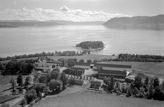
Hovinsholm, Helgøya, Lake Mjosa, Norway
Helgøya means holy island, in Norwegian. There is a lovely double meaning here and such layered history. The manor, in its various iterations, has been on this site since the 1500s. They had their own Christian manor church until 1612.

On the southern tip of the island, there is an old pagan temple to the Norse Gods, Thor, Frigg, Loki, Hod, Heimdall, Tyr, and Baldur.

Here, farmers of the area would gather at four blót sacrifices a year that followed the seasons — one for each of the winter solstice, spring equinox, summer solstice and autumn equinox. Animals would be sacrificed, their blood splattered on altars, walls and folk around them. Toasts were made. The first was in honour of Thor or Odin, “to the king and victory.” 

Odin, although nominally chief of the gods, was more the god of aristocrats. If a king were toasting, particularly a Danish King, it would be for Odin. If you look at place names in Scandinavia, you'll see him conspicuously absent in favour of Thor, the god of the common man.

When the farmers at Helgøya were shouting Skål, it was likely for Thor. The toasting and drinking continued with cups emptied for Njörd and Freyr and Freyja in the hope of securing a prosperous future. 

Finally, personal pledges (and beer-soaked boasts) would be made to undertake great exploits, Valknut — to die well in battle — and finally to kinsmen laid to rest now drinking with the gods in Valhalla. Weapons, jewellery and tools were thrown into the lake as offerings.

If they were gathering for Jol (Old Norse), Jul (Norwegian) or the Yule blót, they'd also make a large sun wheel (picture a circle with a cross in the middle), carve it up with runes, set it on fire and roll it down a hill. 

It was quite a celebration with the festivities going on for three days and nights. With the formalities over, people did as people do  — drink, sing, boast, play games and find someone to bed down with — Gods be good.

Thor and Odin are still going strong nearly 1,000 years after the end of the Viking Age. You'd think that the old Nordic religion — the belief in the Norse gods — disappeared with the introduction of Christianity. That is not the case. There are still folk in Denmark (Odin-lovers) and Norway (Thor's their guy) who follow the old Norse religion and worship its ancient gods — right down to the splatter.

If you visit Norway at Christmas, Jul (Yule), you'll find much more of the pagan than the Christian in the festivities. King Haakon, old Haakon the Good, Hákon Góði or Håkon den Gode,  moved the Winter Solstice or Yule, Jul, Jol blót over to match up with the Christian holiday on December 25th in his attempts to introduce Christianity in the 10th century. Both traditions are still celebrated but without an overtly religious tone.

Old traditions run deep, animals are still sacrificed (but without all the splatter), bread is baked, houses cleaned, beer is abundant and fires warmth the hearth.

After all the drinking, toasting and feasting at the Jul blót, leftover food was not cleaned up but left overnight for the little relatives. Though shy, Nisse like a good feast and failing to offer them their tithe brings ill-fortune.

But we started this journey together admiring a lovely (and oddly festive) Ordovician cephalopod. Go on, picture him in red and white with a little beard. If you fancy a visit to the Ordovician outcrops, you can find them at Nes-Hamar, Norway. 60.0° N, 11.2° E: paleo-coordinates 33.7° S, 10.3° W. Look for gastropods (five known species) and cephalopods (at least 15 species).

If you'd like to visit the burial mound of Haakon the Good, you'll want to head to Seim, Hordaland, about 10 km north of Knarvik. Good 'ol Haakon may have tried to bring Christianity to Norway but he died full Viking — taking an arrow at the Battle of Fitjar. Many of my rellies live in Knarvik. 

We have enjoyed many a sunny afternoon feasting at the Håkonarspelet summer festivals and exploring Haakon's burial mound at Håkonhaugen in Seim.

If you're more of the manor type, you can stop by Hovinsholm gård, Helgøyvegen 850, 2350 Nes på Hedmarken, Norway. 

If you're curious and want to see the farmstead, head on over to: https://www.skafferiet.no/about. 

If you need to square things up with Odin, you're on your own.

E. L. Yochelson. 1963. The Middle Ordovician of the Oslo Region, Norway. 15. Monoplacophora and Gastropoda. Norsk Geologisk Tidsskrift 43 (2):133-213.

Tuesday, 14 December 2021

AMMOLITE: LOVE, GREED AND GLORY

Ammolite from the Bearpaw Formation
Ammolite is an opal-like organic gemstone found primarily along the eastern slopes of the Rocky Mountains of North America. 

The mining of ammolite is a serious business. I happened upon a locality while in search of fossilized oysters along the St. Mary's River in Alberta. It was one of the few times that I have ever been shot at. 

They sunk the wee boat I was using as a raft to haul my finds but I will give them credit for firing warning shots and not actually trying to hit me. With that, I can safely say that ammolite inspires strong emotions amongst fossil collectors — love, greed and glory. 

It is made of the fossilized shells of ammonites, which in turn are composed primarily of aragonite, the same mineral contained in shell nacre, with a microstructure inherited from the shell. It is one of few biogenic gemstones along with amber and pearl.

The chemical composition of ammolite is variable. Aside from aragonite, it may include a mix of calcite, silica, pyrite or wee bits and pieces of other minerals. The shell itself may contain a number of trace elements based on the chemical composition of the original sediments where it was fossilized and chemical goodies carried in from groundwater. Most anything can be found in the mix, but primarily we see aluminium, barium, chromium, copper, iron, magnesium, manganese, strontium, titanium, and vanadium. 

Its crystallography is orthorhombic, a seven-sided crystal system. Its hardness is 3.5–4.5, and its specific gravity is 2.60–2.85. The refractive index of Canadian material (as measured via sodium light, 589.3 nm) is as follows: α 1.522; β 1.672–1.673; γ 1.676–1.679; biaxial negative. Under ultraviolet light, ammolite may fluoresce a mustard yellow.

Ammolite comes from the fossil shells of the Upper Cretaceous disk-shaped ammonites Placenticeras meeki and Placenticeras intercalare, and to a lesser degree, the cylindrical baculite, Baculites compressus. The ammonites that form our Alberta ammolite inhabited a prehistoric, inland subtropical sea that bordered the Rocky Mountains — the Cretaceous Western Interior Seaway. 

As the cephalopods died, they sank to the bottom and were buried by layers of bentonitic mud that eventually became shale. Many gem-quality ammonites are found within siderite concretions. These sediments preserved the aragonite of the shells, preventing them from converting to calcite.

Ammolite: Colourful Microstructure of Aragonite
An iridescent opal-like play of colour is shown in fine specimens in shades of yellow, orange, red, green and gold. 

The iridescence is due to the microstructure of the aragonite: unlike most other gems, whose colours come from light absorption, the iridescent colour of ammolite comes from interference with the light that rebounds from stacked layers of thin platelets that make up the aragonite. 

The thicker the layers, the more reds and greens are produced; the thinner the layers, the more blues and violets predominate. Reds and greens are the most commonly seen colours, owing to the greater fragility of the finer layers responsible for the blues. 

When freshly quarried, these colours are not especially dramatic; the material requires polishing and other treatments to reveal the specimen's full-colour potential.

Ammolite itself is quite thin, generally 0.5–0.8 millimetres (0.02–0.03 inches) thick. This thin coating covers a matrix typically made up of grey to brown shale, chalky clay, or limestone. Truly, when you find these ammonites in the field, they do not look like much. They are perhaps a nice shape but often matte grey and unappealing until prepared.  

Frost shattering of these specimens is common. If left exposed to the elements the thin ammolite tends to crack and flake. Prolonged exposure to sunlight can also lead to bleaching of the generally intense colouration. The cracking results in a tessellated appearance, sometimes described as a "dragon skin" or referred to as a stained glass window pattern. 

Ammolite mined from deeper deposits may be entirely smooth or with a rippled surface. Occasionally a complete ammonite shell is recovered with its structure well-preserved: fine, convoluted lines delineate the shell chambers, and the overall shape is suggestive of a nautilus. While these shells may be as large as 90 centimetres (35.5 inches) in diameter, the iridescent ammonites — as opposed to the pyritized variety — are typically much smaller. Most fossilized shells have had their aragonite pseudomorphously replaced by calcite or pyrite, making the presence of ammolite particularly uncommon.

In 1981, ammolite was given official gemstone status by the World Jewellery Confederation (CIBJO), the same year commercial mining of ammolite began. It was designated the official gemstone of the City of Lethbridge, Alberta in 2007.

Ammolite is also known as aapoak — Kainah for "small, crawling stone" — gem ammonite, calcentine, and Korite. The latter is a Trade name given to the gemstone by the Alberta-based mining company Korite. Roughly half of all ammolite deposits are contained within the Kainah (Kainaiwa) reserve, and its inhabitants play a major role in ammolite mining. Marcel Charbonneau and his business partner Mike Berisoff were the first to create commercial doublets of the gem in 1967. They went on to form Ammolite Minerals Ltd.

Monday, 13 December 2021

BELEMNITES: SQUID-LIKE CEPHALOPODS

Lower Jurassic Belemnites, Photo: Georg Laki
Belemnitida is an extinct order of squid-like cephalopods that swam our ancient seas from the Late Triassic to Late Cretaceous. 

Unlike squid, belemnites had an internal skeleton that made up the cone and it is this hard part that we often find fossilized. 

The parts are, from arms to tip: the tongue-shaped pro-ostracum, the conical phragmocone, and the pointy guard.  

When you find these as fossils, it is not intuitive as to what kind of animal they came from. This is the internal hard part of a rather soft, squishy squid-like fellow. 

Because the softer bits are often scavenged and decay, we rarely see them fossilized. Instead, we get what looks like a pointy selection of cigar-shaped goodies that are all that is left of these marine cephalopods. 

We find this fossil in many places around the world. Some friends shared where they have personally found them which I thought might be of interest to you. Arno Martini has found them in northern California, Anne Glenn finds them in Wyoming, Marco Valentin has an enviable collection from Hannover, Misburg, Germany, Juanjo Ugalde Robledo finds them in La Rioja, Spain, Barbara Hnb finds them in Normandy, Patrick Buster finds them in the Navesink Formation of New Jersey, Kim Pervis shared a monograph on Mississippian Belemnites by Rousseau. 

Georg Laki has collected many of their number in the Early Jurassic (Sinemurian/Pliensbachian) of South Luxembourg at Gasperich. I included a photo of Georg's belemnites (with permission) here for you to enjoy. He has a lovely collection that shows the variety of these fossils. 

Anatomy of a Belemnite Fossil

Other notable finds are from Scott Carpenter and his daughter who collect them on the Jurassic Coast, Gabriel Santos who collects them in Peniche, Portugal and Rossi Franco shared a belemnite he found in the building materials used to construct the Bank of Italy in Genoa. 

There are also some wonderfully preserved plates of multiple Jurassic belemnites from Mistelgau, Germany you may want to take a boo at. Imagine slate grey to honey brown Youngibelus and Paxillosus clusters on a beige matrix. Quite stunning. 

I have found them around British Columbia, as has Lloyd Rempel, including at Harrison Lake, British Columbia, Canada. 

Friday, 29 October 2021

BITS OF HISTORY: CANADA / A GEOLOGIC GEM IN THE MAKING

Canada's early history, like all nations, is written in her rock. The ground we walk upon today on Turtle Island includes some of the oldest rocks on the planet. 

While you and I were not there to witness it, our planet formed a little over 4.5 billion years ago when a massive collection of dust and gas, the leavings of our newly formed Sun, swirled and spun, gathering into a molten liquid sphere.    

Half a billion years later, our planet began to cool, the molten crust hardening into the first of our tectonic plates. 

These giant puzzle pieces moved together and separated over vast expanses of time to form, pull apart and reform into a series of supercontinents divided by ancient oceans. 

As you explore Canada, you can see evidence of our planet's early history. Canadian geology spans four billion years of Earth history. Four. Billion. Years. Yes, that is quite a bit to process for our young minds. The oldest rocks are preserved in the stable Archean crustal blocks of which the largest include the Superior, Slave, Hearne and North Atlantic cratons. These blocks are also the repository for much of Canada’s gold, copper, iron, zinc and diamonds. 

The Archean cratons were stitched together by Paleoproterozoic mountain belts that resulted in supercontinent Nuna and host important deposits of nickel, copper and platinum group elements. The Mesoproterozoic is dominated by the Grenville orogen another old mountain belt that extends from central Ontario to Labrador. Sedimentary basins of these ages are prominently represented on the opposite (northwest) margin of the Canadian Shield in the Northwest Territories.

The modern geometry of Canada has its origins in the breakup of the supercontinent Rodinia. Neoproterozoic rifting led to new ocean basins and to trailing continental margins now prominently represented in the Appalachians, western Cordillera and Arctic Islands. 

Plate tectonics in the lower Paleozoic introduced oceanic crust to the rock record of Newfoundland and southern Quebec and accretion of exotic crustal fragments in Atlantic Canada and the High Arctic. 

Similarly, warm ocean conditions in Cambrian to Devonian time produced widespread carbonate platforms over the St. Lawrence Lowlands, the Western Interior, Mackenzie Corridor, Hudson Bay and the southern Arctic.

Events of the Mesozoic are prominently represented by the accretion of continental fragments to the western margin of North America — the landmass referred to as Turtle Island by many First Nation, . This remained a tectonically active region into Eocene time and during this interval produced important deposits of copper, lead, zinc, molybdenum, gold, silver, tungsten and other commodities. 

The depositional record of these events is partly recorded in the Western Canada Sedimentary Basin which is a prolific producer of oil, gas and coal. Hydrocarbons are also an important part of the sediment accumulation story since the Jurassic off the East Coast. Likewise, the tectonically active Cretaceous to Eocene record in the Arctic Islands relates to the origin of the Arctic Ocean and the independent plate motions of Greenland.

About 80 million years ago, North America separated from Europe, Australia began to rift away from Antarctica, and India broke away from Madagascar. 

Our northern and southern edges abut the United States. Interestingly, at their nearest points, Alaska and Russia are separated by only 4 kilometres (2.5 miles).

Thursday, 21 October 2021

HEROES, VILLAINS AND TYRANTS: HORNBY ISLAND HISTORY

Villains, tyrants and heroes alike are immortalized in the scientific literature as researchers don each new species a unique scientific name — and rename geographic sites with a settlers' mindset. 

If you pick through the literature, it is a whose who of monied European explorers literally making a name for themselves, sometimes at great cost to their rivals. 

This truth plays out on British Columbia's West Coast and gulf islands and on Hornby Island, in particular. 

The beautiful island of Hornby is in the traditional territory of the Pentlatch or K’ómoks First Nation, who call it Ja-dai-aich, which means the outer island — a reference to Hornby being on the outside of Denman Island off the east coast of Vancouver Island. 

The island is a mix of beach and meadow, forest and stream. While I often walk the lower beachfront, this island boasts a lovely and very walkable mixed forest that covers its higher ground. 

If you explore here, off the beaten path, you will see a mix of large conifers — Western Hemlock, Grand Fir and Lodgepole Pine on the island. Of these, the Western Red Cedar, Thuja plicata, is the most prized by First Nations. It is the Tree of Life that provides bountiful raw materials for creating everything from art to homes to totems and canoes. 

If you explore these forests further, you will also see wonderful examples of the smaller Pacific yew, Taxus brevifolia, a wee evergreen that holds a special place in the hearts of First Nations whose carvers use this wood for bows and paddles for canoes.

Many spectacular specimens of arbutus, Arbutus menziesii, grow along the water's edge. These lovely evergreens have a rich orange-red bark that peels away in thin sheets, leaving a greenish, silvery smooth appearance and a satiny sheen. Arbutus, the broadleaf evergreen species is the tree I most strongly associate with Hornby. Hornby has its fair share of broadleaf deciduous trees. Bigleaf maple, red alder, black cottonwood, Pacific flowering dogwood, cascara and several species of willow thrive here.

There are populations of Garry oak, Quercus garryana, with their deeply lobed leaves, on the southern end of the island and at Helliwell Provincial Park on a rocky headland at the northeast end of Hornby. 
Local First Nations fire-managed these stands of Garry oak, burning away shrubs and other woody plants so that the thick-barked oaks and nutritious starch-rich plants like great camas, Camassia leichtlinii, could thrive without any nutrient competitors. 

Only about 260 acres (1.1 km2) of undisturbed stands of older forests have been identified on Hornby. They amount to roughly 3.5% of the island's surface area. There are roughly 1,330 acres (540 ha) of older second-growth stands on the island, roughly 19% of the island.

Most of the trees you see on the island are Douglas fir, Pseudotsuga menziesii, an evergreen conifer species in the pine family. My Uncle Doug recognized this tree species because of how much the bark looks like bacon — a food he loved. The common name is a nod to the Scottish botanist, David Douglas, who collected and first reported on this large evergreen.

Captain George Vancouver's Commission to Lieutenant
Sadly for Douglas, it is Archibald Menzies, a Scottish physician, botanist, naturalist — and David's arch-rival, whose name is commemorated for science. 

He is also credited with the scientific naming of our lovely arbutus trees. 

Menzies was part of the Vancouver Expedition (1791–1795) a four-and-a-half-year voyage of exploration commanded by Captain George Vancouver of the British Royal Navy.

Their voyage was built on the work of James Cook. Cook was arguably the first ship's captain to ensure his crew remained scurvy free by implementing a practice of nutritious meals — those containing ascorbic acid also known as Vitamin C — and meticulous standards for onboard hygiene. 

Though he did much to lower the mortality rate amongst his crew, he made some terrible decisions that led to his early demise. Cook was attacked and killed in 1779 during his third exploratory voyage in the Pacific while attempting to kidnap the Island of Hawaii's monarch, Kalaniʻōpuʻu. 

During the four and a half year Vancouver Expedition voyage, the crew and officers bickered amongst themselves, circumnavigated the globe, touching down on five continents. Little did they know, for many of them it would be the last voyage they would ever take. 

The expedition returned to a Britain more interested in its ongoing war than in Pacific explorations. Vancouver was attacked by the politically well-connected Menzies for various slights, then challenged to a duel by Thomas Pitt, the 2nd Baron of Camelford. 

The fellow for whom the fair city of Vancouver is named never did complete his massive cartographical work. With health failing and nerves eroded, he lost the dual and his life. It was Peter Puget, whose name adorns Puget Sound, who completed Vancouver's — and arguably Cook's work on the mapping of our world.

And while it is now called Vancouver the city has many names as it falls within the traditional territory of three Coast Salish peoples — the Squamish (Sḵwxwú7mesh), Tsleil-waututh and Xwméthkwyiem ("Musqueam"—from masqui "an edible grass that grows in the sea"), and on the southern shores of Vancouver along the Fraser River, the Xwméthkwyiem.

If you would like to explore more of the history of eponymous naming from Linnaeus to Darwin, to Bowie himself, take a boo at a new book from Stephen B. Heard, "Charles Darwin's Barnacle and David Bowie's Spider. It is fresh off the press and chock full of historical and pop-culture icons.

References: The City of Vancouver Archives has three George Vancouver documents of note:
  • The Commission, dated July 10, 1783, appointing him fourth Lieutenant of the HMS Fame (this is the official document confirming a field commission given to him May 7, 1782)
  • A letter to James Sykes (a Navy Agent in London) written from the ship Discovery (not the same Discovery used by Cook) while in Nootka Sound near the end of Vancouver’s exploration of the West Coast, October 2, 1794. Vancouver states that they have determined that the Northwest Passage does not exist, which was one of the main goals of his voyage
  • A letter to James Sykes written from Vancouver’s home in Petersham, England, after his voyage, October 26, 1797 

Monday, 13 September 2021

FOSSIL FAUNA OF HAIDA GWAII

This lovely slate grey and beige ammonite with the fine ribbing is Brewericeras hulenense (Anderson 1938) — a fast-moving, nektonic (no idle floating here!) carnivorous ammonite from the Lower Cretaceous (Albian) of Haida Gwaii, British Columbia, Canada.

This specimen is just over 12cm in length, a little under the average of 13.4cm. There are several localities in the islands of Haida Gwaii where Brewericeras can be found — six that I know of and likely plenty more.

The islands of Haida Gwaii lay at the western edge of the continental shelf due west of the central coast of British Columbia. 

They form Wrangellia, an exotic tectonostratigraphic terrane that includes Vancouver Island, parts of western British Columbia and Alaska.

It is always interesting to see who was making a living and co-existing in our ancient oceans at the time these fossils were laid down. 

We find multiple beautifully preserved specimens of the spiny ammonite, Douvelleiceras spiniferum along with Brewericeras hulenense (shown here), Cleoniceras perezianum and many cycads in concretion.

The Lower Jurassic ammonite faunas found at Haida Gwaii are very similar to those found in the Eastern Pacific around South America and in the Mediterranean. 

The strata exposed at Maple Island, Haida Gwaii are stratigraphically higher than the majority of Albian localities in Skidegate Inlet. The macrofossil fauna belonged to the Upper part of the Sandstone Member of the Haida formation.

The western end of the island contains numerous well-preserved inoceramids such as Birostrina concentrica and a few rare ammonites of Desmoceras bearskinese

The eastern shores are home to unusual ammonite fauna in the finer-grained sandstones. Here we find the fossils as extremely hard concretions while others were loose in the shale. Species include Anagaudryceras sacya and Tetragonites subtimotheanus. A large whorl section of the rare Ammonoceratites crenucostatus has also been found here. 

Saturday, 4 September 2021

STANLEY PARK: HIDDEN HISTORY

Anavitrinella pampinaria / Dan Bowden Photography
A Common grey moth of the family Geometridae. We begin to see them in the fossil record some 200 million years ago. 

These lovelies live in North America from Mexico to Alaska and do a wonderful job at camouflage. 

While not a perfect hiding spot, this fellow has chosen to settle in for the evening on a young yellow cedar tree, Chamaecyparis nootkatensis, in Vancouver's Stanley Park — a 405-hectare urban forest in Vancouver, B.C. that became a provincial park in 1887. 

This area was once the exclusive domain of the Coast Salish First Nations —  xʷmə?kʷəyəm (Musqueam), Skwxwú7mesh (Squamish), and səlilwətaɬ (Tsleil-Waututh) Nations until the early 1800s. 

Blending into that mix in the mid-1800s was a group of mixed Portuguese-Squamish settlers who called the eastern shores of the park at Brockton Point home from the mid-1800s to the 1930s. 

Brockton Point. City of Vancouver Archives, CVA 677-228
On the park's northern shores, there were well established Squamish First Nations villages — Whoi Whoi known today as Lumberman's Arch and Chaythos, which we now call Prospect Point. 

There was also a well-established Hawaiian settlement at Kanaka Ranch closer to the park's entrance near Coal Harbour. 

Many individuals from Vancouver's growing Chinese population lived peacefully alongside squirrels, coyotes, racoons and other wildlife within the natural beauty of the park. Enticed to British Columbia by the lure of gold but finding the riches far less than expected, they took to the forest in Stanley Park to make out of the way homes for themselves. That, of course, did not last. All of the residents in and around the newly minted park were ousted with ill regard for their welfare. 

You may know of one of the families, Khatsahlano, from whence my community of Kitsilano gets its name. August Jack Khatsahlano (July 16, 1877 – June 5, 1971), lived in Whoi Whoi alongside eleven other families. August Jack Khatsahlano or X̱ats'alanexw, was born in the village of Xwayxway on the peninsula that is now Stanley Park, Vancouver/Chaythoos, British Columbia.

He was the son of Supple Jack "Khay- Tulk" of Chaythoos and Sally "Owhaywat" from the Yekwaupsum Reserve north of Squamish, British Columbia. His grandfather was Chief Khahtsahlano of Senakw (Snauq or Sun'ahk) who migrated from his home at Toktakanmic on the Squamish River to Chaythoos, from whence he inherited his name. The suffix lan-ogh means man. In an interview with Vancouver's first archivist, Khatsahlano recounts:

Stanley Park, Vancouver, BC
“When they make [the] Stanley Park road, we were eating [breakfast] in our house. Someone make noise outside; chop our house. We were inside the house when the surveyors came along, and they chop the corner of our house while we were eating inside.”

You can imagine taking just what you can carry and walking into the unknown of where you will sleep that night and make a home in the future. It saddens me that we treat people so poorly, historically and now. 

We also treat our wildlife poorly. There are plans to capture and kill the coyotes in Stanley Park today as they are a nuisance to those visiting the park. We might consider that we are a nuisance to them. 

The only real winners in Stanley Park are the trees, birds and insects, including lovelies like this grey moth. In the Kwak̓wala language of the Kwakiutl or Kwakwaka'wakw, speakers of Kwak'wala, of the Pacific Northwest and part of my heritage, yellow cedar is dixw, and a moth is ma̱stła̱ḵ̕wa or ma̱stła̱ḵ̕wani

The thin, greyish-brown and scaly bark provides a pretty good cover. He was caught unawares and photographed beautifully by the hugely talented, Dan Bowden on a visit to the city.

Friday, 27 August 2021

ICE AGE MANATEES

Manatees do not live year-round in Texas, but these gentle sea cows are known to occasionally visit, swimming in for a summer vacation and returning to warmer waters for the winter. 

Interestingly, we have recently found fossil evidence for manatees along the Texas coast dating back to the most recent ice age. 

The discovery raises questions about whether manatees have been visiting for thousands of years, or if an ancient population of ice age manatees once called Texas home.

The findings were published in Palaeontologia Electronica by lead author Christopher Bell, a professor at the UT Jackson School of Geosciences with co-authors Sam Houston State University Natural History Collections curator William Godwin and SHSU alumna Kelsey Jenkins — now a graduate student at Yale University — and SHSU Professor Patrick Lewis.

The eight fossils described in the paper include manatee jawbones and rib fragments from the Pleistocene, the geological epoch of the last ice age. Most of the bones were collected from McFaddin Beach near Port Arthur and Caplen Beach near Galveston during the past 50 years by amateur fossil collectors who donated their finds to the SHSU collections.

The Jackson Museum of Earth History at UT holds two of the specimens. A lower jawbone fossil, which was donated to the SHSU collections by amateur collector Joe Liggio, jumpstarted the research.

Manatee jawbones have a distinct S-shaped curve that immediately caught Godwin's eye. But Godwin said he was met with scepticism when he sought other manatee fossils for comparison. He recalls reaching out to a local fossil enthusiast who told him point-blank, "there are no Pleistocene manatees in Texas."

But an examination of the fossils by Bell and Lewis proved otherwise. The bones belonged to the same species of manatee that visits the Texas coast today, Trichechus manatus. An upper jawbone donated by U.S. Rep. Brian Babin was found to belong to an extinct form of the manatee, Trichechus manatus bakerorum.

The age of the manatee fossils is based on their association with better-known ice age fossils and paleo-Indian artefacts that have been found on the same beaches.

It is assumed that the cooler ice age climate would have made Texas waters even less hospitable to manatees than they are today. But the fact that manatees were in Texas — whether as visitors or residents — raises questions about the ancient environment and ancient manatees. The Texas coast stretched much farther into the Gulf of Mexico and hosted wider river outlets during the ice age than it does today. Either the coastal climate was warmer than is generally thought, or ice age manatees were more resilient to cooler temperatures than manatees of today.

Subsurface imaging of the now flooded modern continental shelf reveals both a greater number of coastal embayments and the presence of significantly wider channels during ice age times.

If there was a population of ice age manatees in Texas, it is entirely plausible that they would have ridden out winters in these warmer river outlets similar to how they do today in Florida and Mexico.

Reference: Christopher Bell, William Godwin, Kelsey Jenkins, Patrick Lewis. First fossil manatees in Texas: Trichechus manatus bakerorum in the Pleistocene fauna from beach deposits along the Texas Coast of the Gulf of Mexico. Palaeontologia Electronica, 2020; DOI: 10.26879/1006

Sunday, 22 August 2021

CAVE BEAR: URSUS URALENSIS

This glorious and slightly terrifying skull is from a fossil cave bear, Ursus uralensis, from Pleistocene deposits in Russia.

Both the cave bear and the brown bear are thought to be descended from the Plio-Pleistocene Etruscan bear, Ursus etruscus, that lived about 5.3 Mya to 100,000 years ago. 

The last common ancestor of cave bears and brown bears lived between 1.2–1.4 Mya. The immediate precursor of the cave bear was probably Ursus deningeri, the Deninger's bear — a species restricted to Pleistocene Europe about 1.8 Mya to 100,000 years ago. 

The transition between Deninger's bear and the cave bear is given as the last interglacial, although the boundary between these forms is arbitrary, and intermediate or transitional taxa have been proposed, Ursus spelaeus deningeroides, while other authorities consider both taxa to be chronological variants of the same species.

Cave bears found in different regions vary in age, thus facilitating investigations into evolutionary trends. The three anterior premolars were gradually reduced, then disappeared, possibly in response to a largely vegetarian diet. 

In a fourth of the skulls found in the Conturines, the third premolar is still present, while more derived specimens elsewhere lack it. The last remaining premolar became conjugated with the true molars, enlarging the crown and granting it more cusps and cutting borders. This phenomenon, called molarization, improved the mastication capacities of the molars, facilitating the processing of tough vegetation. This allowed the cave bear to gain more energy for hibernation while eating less than its ancestors.

A lone Grizzly Bear / Na̱ndzi
In 2005, scientists recovered and sequenced the nuclear DNA of a cave bear that lived between 42,000 and 44,000 years ago. 

The procedure used genomic DNA extracted from one of the animal's teeth. Sequencing the DNA directly (rather than first replicating it with the polymerase chain reaction), the scientists recovered 21 cave bear genes from remains that did not yield significant amounts of DNA with traditional techniques.

This study confirmed and built on results from a previous study using mitochondrial DNA extracted from cave bear remains ranging from 20,000 to 130,000 years old. 

Both show that the cave bear was more closely related to the brown bear and polar bear than it was to the American black bear, but had split from the brown bear lineage before the distinct eastern and western brown bear lineages diversified and before the split of brown bears and polar bears. The divergence date estimate of cave bears and brown bears is about 1.2–1.4 Mya. However, a recent study showed that both species had some hybridization between them.

We are blessed to have them living amongst us today on the rugged west coast of British Columbia. In the Kwak'wala language of the Kwakiutl First Nations of the Pacific Northwest, this big fellow is na̱ndzi — a lovely, large peaceful bear.

Saturday, 21 August 2021

MUSKOX: CAPRINAE

Look at this soulful fellow. He is a muskox who spends his days slowly meandering through these gorgeous fields eating his fill of nutritious plants on the open tundra. They are social animals, moving together in large herds. 

As a member of the subfamily Caprinae of the family Bovidae, the muskox is more closely related to sheep and goats than to oxen. It has been placed in its own genus, Ovibos — Latin for sheep-ox. It is one of the two largest extant members of Caprinae, along with the similarly sized takin.

While the takin and muskox were once considered possibly closely related, the takin lacks common ovibovine features, such as the muskox's specialized horn morphology, and genetic analysis shows that their lineages actually separated early in caprine evolution. 

Instead, the muskox's closest living relatives appear to be the gorals of the genus Naemorhedus, nowadays common in many countries of central and east Asia. The vague similarity between takin and muskox must therefore be considered an example of convergent evolution.

The modern muskox is the last member of a line of ovibovines that first evolved in temperate regions of Asia and adapted to a cold tundra environment late in its evolutionary history. They lived alongside our lovely Mammoths and would have competed for the same plant resources as those much larger beasts. 

Muskox ancestors with sheep-like high-positioned horns — horn cores being mostly over the plane of the frontal bones, rather than below them as in modern muskoxen — first left the temperate forests for the developing grasslands of Central Asia during the Pliocene, expanding into Siberia and the rest of northern Eurasia. 

Later migration waves of Asian ungulates, including the high-horned muskox, reached Europe and North America during the first half of the Pleistocene. The first well-known muskox, the "shrub-ox" Euceratherium, crossed to North America over an early version of the Bering Land Bridge two million years ago and prospered in the American southwest and Mexico. Euceratherium was larger yet more lightly built than modern muskoxen, resembling a giant sheep with massive horns, and preferred hilly grasslands.

A genus with intermediate horns, Soergelia, inhabited Eurasia in the early Pleistocene, from Spain to Siberia, and crossed to North America during the Irvingtonian (1.8 million years to 240,000 years ago), soon after Euceratherium. Unlike Euceratherium, which survived in America until the Pleistocene-Holocene extinction event, Soergelia was a lowland dweller that disappeared fairly early, displaced by more advanced ungulates, such as the "giant muskox" Praeovibos (literally "before Ovibos"). 

The low-horned Praeovibos was present in Europe and the Mediterranean 1.5 million years ago, colonized Alaska and the Yukon one million years ago and disappeared half a million years ago. Praeovibos was a highly adaptable animal that appears associated with cold tundra (reindeer) and temperate woodland (red deer) faunas alike. 

During the Mindel glaciation 500,000 years ago, Praeovibos was present in the Kolyma river area in eastern Siberia in association with many Ice Age megafauna that would later coexist with Ovibos, in the Kolyma itself and elsewhere, including wild horses, reindeer, woolly mammoth and stag-moose. 

It is debated, however, if Praeovibos was directly ancestral to Ovibos, or both genera descended from a common ancestor since the two occurred together during the middle Pleistocene. Defenders of ancestry from Praeovibos have proposed that Praeovibos evolved into Ovibos in one region during a period of isolation and expanded later, replacing the remaining populations of Praeovibos.

Two more Praeovibos-like genera were named in America in the 19th century, Bootherium and Symbos, which are now identified as the male and female forms of a single, sexually dimorphic species, the "woodland muskox", Bootherium bombifrons. Bootherium inhabited open woodland areas of North America during the Late Pleistocene, from Alaska to Texas and maybe even Mexico, but was most common in the Southern United States, while Ovibos replaced it in the tundra-steppe to the north, immediately south of the Laurentian ice sheet.

Modern Ovibos appeared in Germany almost one million years ago and were common in the region through the Pleistocene. Muskoxen had also reached the British Isles. Both Germany and Britain were just south of the Scandinavian ice sheet and covered in the tundra during cold periods, but Pleistocene muskoxen are also rarely recorded in more benign and wooded areas to the south like France and Green Spain, where they coexisted with temperate ungulates like red deer and aurochs. Likewise, the muskox is known to have survived in Britain during warm interglacial periods.

Today's muskoxen are descended from others believed to have migrated from Siberia to North America between 200,000 and 90,000 years ago, having previously occupied Alaska (at the time united to Siberia and isolated periodically from the rest of North America by the union of the Laurentide and Cordilleran Ice Sheets during colder periods) between 250,000 and 150,000 years ago. 

After migrating south during one of the warmer periods of the Illinoian glaciation, non-Alaskan American muskoxen would be isolated from the rest in the colder periods. The muskox was already present in its current stronghold of Banks Island 34,000 years ago, but the existence of other ice-free areas in the Canadian Arctic Archipelago at the time is disputed.

Along with the bison and the pronghorn, the muskox was one of a few species of Pleistocene megafauna in North America to survive the Pleistocene/Holocene extinction event and live to the present day. The muskox is thought to have been able to survive the last glacial period by finding ice-free areas (refugia) away from prehistoric peoples.

Fossil DNA evidence suggests that muskoxen were not only more geographically widespread during the Pleistocene, but also more genetically diverse. During that time, other populations of muskoxen lived across the Arctic, from the Ural Mountains to Greenland. By contrast, the current genetic makeup of the species is more homogenous. Climate fluctuation may have affected this shift in genetic diversity: research indicates colder periods in Earth's history are correlated with more diversity and warmer periods with more homogeneity.

Friday, 13 August 2021

THE CALL OF THE WILD: ANTARCTIC FUR SEALS

This little cutie is an Antarctic fur seal pup. He and his Mamma belong to the species Arctocephalus gazella — pinnipeds that live in dense colonies alongside King Penguins. 

These two call the South Georgia islands home, as do 95% of the world's fur seal population.  

Though a wee pup, he can already recognize her voice from all the other lovely Mammas in his busy, noisy colony. Little ones left on the rocky shores while their mother is out hunting will raise their heads and listen for their mother's voice. They can distinguish its vocal pitch over the loud calls of all the other busy Mammas and penguins of the colony. If you look closely, you can see his wee little ears. Antarctic fur seals, unlike some other seal species, have visible ears.  

Seal pups stay with their mother, relying on her lactation milk to help them fatten up and grow healthy and strong. For the first four months of their lives, their mother will feed them on her rich milk, then head out to sea to forage for food. 

Once she is back, she will call out to him and then give him a good sniff upon their reunion, the final confirmation for both parties that the right match has been made. The interaction between mother and pup is tender and heartbreakingly sweet to watch. She only gives birth to one pup (two is rare) each October to December. Pups are born with a sheen of fur and grow their waterproof fur during their first months of life. 

When this little fellow grows up, he will dine on fish, birds (including his penguin pals), squid and krill. Krill are small crustaceans of the order Euphausiacea that look like tiny shrimp. They look similar and are both crustaceans but shrimp hail from the suborder Natantia, order Decapoda and their hearts are located in their heads.

Krill live in all the world's oceans and sadly for them, they make a handy and tasty snack. They form an important part of the oceanic food chain. The krill feed on phytoplankton and zooplankton and then larger animals feed on the krill. 

Krill is Norwegian for small fry of fish. And they are small, indeed — but also tasty, nutritious and easy to catch. Once this little pinniped pup is out hunting on his own, krill will make up the majority of his adult diet. He will need our help to make sure he gets a steady supply. Krill are one of the casualties of ocean acidification from climate change. Hopefully, we will do better so they can, too.

Wednesday, 11 August 2021

TRACKING WHALES WITH BARNACLES

We can trace the lineage of barnacles back to the Middle Cambrian. That is half a billion years of data to sift through. 

If you divide that timeline in half yet again, we begin to understand barnacles and their relationship to other sea-dwelling creatures — with a lens that reveals ancient migration patterns.

Barnacles are in the infraclass Cirripedia in the class Maxillopoda. They are marine arthropods related to crabs and lobsters. 

In the Kwak̓wala language of the Kwakiutl or Kwakwaka'wakw, speakers of Kwak'wala, of the Pacific Northwest, barnacles are known as k̕wit̕a̱'a and broken barnacle shells are known as t̕sut̕su'ma. Unless scraped off, barnacles live on one single sturdy object for their entire lives — 8 to 20 years — while chowing down on tasty snacks like plankton and algae they absorb from the surrounding water.

One of the most interesting aha moments in palaeontology came from the study of 270,000 million-year-old k̕wit̕a̱'as. These sticky wee crustaceans have enabled us to trace the course of ancient whale migration. 

University of California Berkeley doctoral student Larry Taylor published some clever findings on how fossil barnacles hitched a ride on the backs of humpback and grey whales millions of years ago and used this data to reconstruct the migrations of ancient whale populations.

The barnacles record details about the whales’ yearly travels in the fossil record. By following this barnacle trail, Taylor et al. were able to reconstruct migration routes of whales from millions of years in the past.

Today, Humpback whales come from both the Southern Hemisphere (July to October with over 2,000 whales) and the Northern Hemisphere (December to March about 450 whales along with Central America) to Panama (and Costa Rica). They undertake annual migrations from polar summer feeding grounds to winter calving and nursery grounds in subtropical and tropical coastal waters.

One surprise find is that the coast of Panama has been a meeting ground for humpback whales going back at least 270,000 years. To see how the barnacles have travelled through the migration routes of ancient whales, the team used oxygen isotope ratios in barnacle shells and measured how they changed over time with ocean conditions. 

Did the whale migrate to warmer breeding grounds or colder feeding grounds? Barnacles retain this information even after they fall off the whale, sink to the ocean bottom, and become fossils. As a result, the travels of fossilized barnacles can serve as a proxy for the journeys of whales in the distant past.

Barnacles can play an important role in estimating paleo-water depths. The degree of disarticulation of fossils suggests the distance they have been transported, and since many species have narrow ranges of water depths, it can be assumed that the animals lived in shallow water and broke up as they were washed down-slope. 

Barnacles have few predators. Their one nemesis is the whelk. It seems that catching a lifetime's ride on a passing whale would have extended their ability to feed on plankton in a variety of settings whelk-free and likely live longer than they might have cemented to something closer to the seafloor.

Monday, 22 March 2021

ICHTHYOSAURS, SHARKS AND BLUBBER

We've learned much about the mighty ichthyosaur since first discovering their bones in Wales back in 1699. That's over three hundred years of knowledge.

We have classified them as an extinct order of marine reptiles from the Mesozoic era. We know that they were visibly dolphin-like in appearance and share some other qualities as well. They were warm-blooded, used their colouration as camouflage and had insulating blubber to keep them warm.

Ichthyosaurs are interesting because they have many traits in common with dolphins, but are not at all closely related to those sea-dwelling mammals. We aren't exactly sure of their biology either. They have many features in common with living marine reptiles like sea turtles, but we know from the fossil record that they gave live birth, which is associated with warm-bloodedness. This study reveals some of those biological mysteries.

We find their fossil remains in outcrops spanning the mid-Cretaceous to the earliest Triassic. As we look through the fossils, we see a slow evolution in body design moving towards that enjoyed by dolphins and tuna by the Upper Triassic, albeit with a narrower, more pointed snout.

Johan Lindgren, Associate Professor at Sweden's Lund University and lead author on the paper,  described the 180 million-year-old specimen, Stenopterygius, from outcrops in the Holzmaden quarry in Germany.

Both the body outline and remnants of internal organs are clearly visible in the specimen. Remarkably, the fossil is so well-preserved that it is possible to observe individual cellular layers within its skin.

Stenopterygius quadriscissus
Researchers identified cell-like microstructures containing pigment organelles on the surface of the fossil.

This ancient skin revealed a feature we recognized from marine dwelling animals, the ability to change colour, providing camouflage from potential predators. They also found traces of what might have been the animal's liver.

When they put some of the tissue through chemical analysis, it was consistent with what we'd look for in adipose tissue or blubber. Not surprising as dolphins today use blubber for buoyancy and to help to thermally insulate for thermal regulation in cold seas. It's a highly useful adaptation and one that led me to wonder what other vertebrates might use blubber or some other adaptation to maintain a warmer body temperature independent of icy cold conditions.

Today, blubber is an important part of the anatomy of seals, walruses and whales. It covers the core of their bodies, storing energy, insulating them from cold seas and providing extra buoyancy. 

A rather fetching Walrus, Odobenus rosmarus
Fat and blubber are not the same. The main differences are their consistency and blood supply —  blubber contains many more blood vessels than fat, and is far denser because it's made up of a mix of collagen fibres and lipids.

Blubber layers can be incredibly thick. Walruses deposit most of their body fat into a thick layer of blubber — a layer of fat reinforced by fibrous connective tissue that lies just below the skin of most marine mammals.

This blubber layer insulates the walrus and streamlines its body. It also functions as an energy reserve. Blubber covers the core of their bodies but does not grace their fins, flippers and flukes.

Not all marine animals need blubber. Our cold-blooded marine friends: sharks, crabs, fish, are able to let their body temperatures dropdown to very chilly levels, some as low as 36 degrees Fahrenheit.

They have a few tricks up their sleeves to make this happen. Sharks have evolved specialized physiology to keep their metabolic rate high and their hearts are able to contract in the icy depths because of a special protein. These adaptations allow sharks to enjoy a wide range of habitats and follow their food from warm tropical seas to the icy waters of the North Pacific.

Gray Shark, Carcharhinus amblyrhynchos
With the advent of genetics, we've now learned that the Great White Shark’s genetic code and many of the proteins they use to control metabolism are more closely related to humans than zebrafish, the quintessential fish model.

In a very cool bit of science, researchers sequenced a shark's heart transcriptome – the messenger molecules produced from the shark’s genome, including those active in making proteins. Then they categorized the proteins based on their functions.

What they found that the proportions of white shark proteins in many categories matched humans more closely than zebrafish. Of particular interest was that white shark had a closer match to humans for proteins involved in metabolism. Great White Sharks have a rare trait in fish called regional endothermy. This allows them to keep the body temperature of some of their organs warmer than the ambient water — a highly useful trait for fast swimming, digestion and hunting in colder waters.

References and additional reading:

Fancy a read? Check out the work by Michael Stanhope, professor of evolutionary genomics at Cornell’s College of Veterinary Medicine, and scientists at the Save Our Seas Shark Research Center at Nova Southeastern University (NSU). He published the shark genetic study in the November 2013 issue of BMC Genomics. It lays the foundation for genomic exploration of sharks and vastly expands genetic tools for their conservation.

Johan Lindgren, Peter Sjövall, Volker Thiel, Wenxia Zheng, Shosuke Ito, Kazumasa Wakamatsu, Rolf Hauff, Benjamin P. Kear, Anders Engdahl, Carl Alwmark, Mats E. Eriksson, Martin Jarenmark, Sven Sachs, Per E. Ahlberg, Federica Marone, Takeo Kuriyama, Ola Gustafsson, Per Malmberg, Aurélien Thomen, Irene Rodríguez-Meizoso, Per Uvdal, Makoto Ojika, Mary H. Schweitzer. Soft-tissue evidence for homeothermy and crypsis in a Jurassic ichthyosaur. Nature, 2018; DOI: 10.1038/s41586-018-0775-x

North Carolina State University. (2018, December 5). Soft tissue shows Jurassic ichthyosaur was warm-blooded, had blubber and camouflage. ScienceDaily. Retrieved September 7, 2019, from www.sciencedaily.com/releases/2018/12/181205134118.htm

Photo: By Haplochromis - Own work, CC BY-SA 3.0, https://commons.wikimedia.org/w/index.php?curid=5825284

Friday, 5 March 2021

SUSAN'S HOLCOPHYLLOCERAS

What is wonderful about natural science is exploring new species. Take a look at this tremendously robust suturing on this lovely ammonite, Holcophylloceras mediterraneum, (Neumayr, 1871) from Late Jurassic (Oxfordian) deposits near Sokoja, Madagasgar. This particular specimen and post goes out to Susan Gerard who has provided lovely cabinetry that will become home for so many of these wonderfully preserved specimens.  

Madagascar is a treasure trove of outstanding fossil species and this Holcophylloceras ammonite is no exception.

The shells had many chambers divided by walls called septa. The chambers were connected by a tube called a siphuncle which allowed for the control of buoyancy with the hollow inner chambers of the shell acting as air tanks to help them float.

We can see the edges of this specimen's shell where it would have continued out to the last chamber, the body chamber, where the ammonite lived. Picture a squid or octopus, now add a shell and a ton of water.

Friday, 27 November 2020

TSAXIS, FORT RUPERT: DEATH OF THE LAST SLAVE ON THE NORTH COAST

In the Pacific Northwest, slavery and slave trading was common practice recorded for hundreds of years and likely practised for thousands.

The British Empire abolished slavery in 1833. While it was illegal, its practice continued in various ways around the world.

In December 1946, the magazine The Beaver, now published as Canada's History Archive, interviewed Elizabeth Hunt Wilson, who grew up amongst slaves, slave traders, settlers and First Nations on the west coast of British Columbia, when slavery was still common practice. 

She recounted a tale of the murder of the last slave in her village — a man still held as a slave more than fifty years after its official abolishment — in the village of Tsax̱is, Fort Rupert on northern Vancouver Island, British Columbia, Canada.

The story holds special importance for me as she is the sister of my great-great-grandfather, William Hunt who married Annie Wilson (Kwagu’ł / Kwakiutl) — and my great-great-aunts and uncles — Sarah Edna Hunt Lyon, Emily Hunt, George Hunt (Ethnographer who worked with Franz Boas), Eli Fredrick Hunt, Mary (who died young), Robert James Jr. Hunt (died as a young man),  Jane Charity Hunt Cadwallader, Mary Hunt (named for the one who died), and Annie Hunt Spencer. 

Elizabeth was also the last surviving daughter of Robert Hunt and Mary Ebbetts — whom you may know as Anislaga or Anisalaga — the All-Mother. 

Robert Hunt had come to British Columbia in 1850 as an ambitious man. He worked first as a labourer, then postman and later worked his way up to run the Hudson's Bay Company's fort at Fort Rupert. 

Elizabeth's mother, Mary Ebbetts was born Asnaq of the Raven/Yéil phratry of the Gigalgam Kyinanuk Tlingit of Tongas and Larhtorh/Larhsail of Cape Fox. She was the daughter of Chief Keishíshk' Shakes IV and his wife, S’eitlin — a Deisheetaan (Gaanax.ádi) from Aan goon (Angoon), and granddaughter to the Head-Chief of Wrangell. She was a high-ranking daughter which made her the perfect bride. 

Anislaga married Robert Hunt of the Hudson's Bay Company at Fort Simpson at Lax-Kw'alaams on the Nass River while staying with the Tsimshian. 

They lived in the north then relocated to Fort Rupert where they had eleven children — seven daughters and four sons, including sweet Elizabeth.

Elizabeth was born into a time when Sir Anthony Musgrave was the governor of the united Colony of British Columbia and Sir. John A. Macdonald was Prime Minister of Canada.   

Macdonald, once been tepid on the question of the westward expansion of the Canadian provinces, became a zealot once in power. 

As Prime Minister, he became a strong supporter of a bi-coastal Canada and the commerce that would bring. Immediately upon Confederation, he sent commissioners to London who eventually negotiated the transfer of Rupert's Land and the North-Western Territory to Canada. 

It was expansion into the west that led to Elizabeth's parents meeting and marrying — a binding of two cultures.  

Macdonald wished to secure the colony of British Columbia and ensure his new nation had a Pacific outlet. Both Fort Victoria (est. 1843) and Fort Rupert (est. 1849-51) — were central to these plans. Once the fort was established, 600-700 First Nations from more than twenty lineages lived near the site. Once smallpox washed through the community, that number was closer to 300-350. 

Robert Hunt, now factor, and Anislaga left Fort Rupert in 1868 to run the Fort Simpson site for the HBC. They returned to Tsax̱is, Fort Rupert in 1872 in time to give birth to their daughter, Jane Charity in 1873.

Anislaga's Chilkat Naaxein woven for William Hunt
A few years earlier, in 1870, while Anislaga, Elizabeth's mother was giving birth to Elizabeth in Fort Simpson and during the first months of her young life, negotiations were being conducted to bring British Columbia into the Confederation. 

This was at a time when cannibalism, as part of slave or child sacrifices, was still common practice.

The politics of the rest of Canada were unknown to her as she worked and played as a young girl. Elizabeth grew up in the remote, windswept village of Tsax̱is, Fort Rupert, a community built above the clam filled tidal flats in Beaver Cove eleven kilometres south of Port Hardy. It was my home as a girl and I think back on my childhood there with great fondness and try to imagine it when Elizabeth was a girl. 

Growing up, the only thing that remained of the old Hudson's Bay Company (HBC) fort was the old chimney and the graveyard a wee bit further south of the main fort site. I grew up beside the graveyard and spent many happy days playing amongst their long lost souls.

The fort site is just up the hill past the main reserve as you head south. Most of the fort was destroyed in the early 1940s. When Elizabeth was a girl, she knew the fort during its heyday — a trading shop, offices,  kitchens, living quarters, blacksmith, hardens and livestock pens filled its high walls. 

The area was established as much for the fur trade as it was for the local coal mining deposits. The fort was built in a military fashion with an eighteen-foot wooden palisade, both inner and outer gates — naively built from green wood — and metal cannons. The fort was the centre of trade and many tales of local conflict — both settler and First Nation.

Local Kwakiutl warriors took shelter within its walls to guard against marauding braves. Robert and Anislaga had run a thriving business, but that slowly declined. A fire took four of the houses and one life in 1868 — foreshadowing its demise as an HBC fort. 

Her father, Robert Hunt, my great-great-great-grandfather, purchased it from the Hudson's Bay Company in 1873. 

Elizabeth also spent time in Alert Bay and twenty years up in Rivers Inlet with her husband Daniel Wilson, a hale Scot who loved the west coast and First Nation traditions. She witnessed and heard stories of Haida raids on the Tsimshian First Nation near Prince Rupert and Alaska's Annette Islands and Coast Salish along the coast of Vancouver Island and British Columbia — capturing slaves and seizing valuable goods to bring home to Haida Gwaii in the hold of their large and skillfully built red cedar war canoes imbued with spirits — each act fomenting retaliation by the First Nation clans targeted. 

Haida canoes were the perfect fishing and raiding crafts. They were hewn from a single carefully chosen red cedar, felled in the fall. The wood would be prepared by burning and carved over the winter into a dugout that paddled true and could hold as many as 40 warriors.

When Elizabeth was eight or nine, a year or two after the Indian Act of 1876 was enacted, some warriors of the Cowichan First Nations captured and killed the sister of a Kwagu’ł Chief at Tsax̱is, Fort Rupert. 

The Chief's wife had brothers who were incensed by the slaughter and planned their own. They paddled down to the Cowichan village, killed four Cowichan First Nation warriors. Vanquished, the brothers returned home, their canoe held the body of their murdered sister and four dismembered heads of the Cowichan First Nation mounted on spears — the only witnesses to their vengeance. A funeral was prepared to honour their lost sibling. A Cowichan woman who had been captured as a slave was dressed in finery and brought to the mortuary tree where the sister's remains were to be interned. Gifts were bestowed upon her for her journey to the burial site and once there, she was shot and killed.  

The banning of the potlatch by Canadian law came into effect in 1884. A few years after the ban, when she was twenty, one of her sisters told her of a potlatch held by a Chief of the Kwagu’ł that her sister had attended. Potlatches take time to prepare for as the lineage Chief would consult with the oldest members of the household group and everyone would be involved. Though the ban had come into effect, preparations would have been well underway and the date already set.

Part of those preparations was the amassing of food and gifts for those invited as guests. Ceremonial pieces would be carved, Coppers polished and plans for what to give — or what to destroy — as the outright destruction of property is the ultimate mark of rank. One of the most valuable items you could destroy as part of your property was slaves.   

The Kwakiutl had Hamastas, members chosen to embody the ancient cannibals of their ancestors and act out ritualized cannibalism, most often at potlatch celebrations. These ritualistic dances are passed down through the lineage and are still practised today.

Although it was long past the time when slavery had been formally outlawed, slavery was still practised along the coast and the last slave held by the Kwakiutl First Nations was serving at the celebrations. His master, the son of a Chief, stabbed him to death in a frenzy at the close of a potlatch. He would later serve jail time for the murder but come home fluent in English and well-thought-of by his peers for the adventures he had been on and for the great wealth he had dispatched, both in blankets and gifts and by the ultimate offering — the killing of a slave.

Elizabeth Hunt Wilson's husband was the accountant at one of the canneries in Rivers Inlet — possibly the Beaver Cannery. Alec Spencer would meet her when she came to Port Hardy on the Union Steamship. She would descend the vessel in her Hudson's Bay Company coat looking grand. Elizabeth Hunt Wilson fondly remembered as Aunt Lizzie died in 1954. The Vancouver Province ran a front line headline, "Fourth Coffin Ready, Aunt Lizzie Dies," to mark her departure. 

Elizabeth Hunt Wilson passed away as a widow with no children. She was an independent spirit. She kept a casket she was buried in was kept in her basement. Before she passed, Aunt Lizzie gave her casket to family members that had passed. This happened three times. Folk like Sally McMahon and Dusty would play funeral, taking turns being the departed while others sang hymns. When Aunt Lizzie passed Dusty inherited her house. 

References: The Beaver Magazine, Issue: December 1946. 

Note: The Beaver magazine was founded and published, during eras shaped by colonialism. Concepts such as racial, cultural, or gender equality were rarely, if ever, considered by the magazine or its contributors. In earlier issues, you find comments and terms now considered to be derogatory. It was originally published by the Hudson's Bay Company and is not partially funded by them and published by Canada’s History Society as Canadas History.

https://canadashistory.partica.online/.../flipbook/32/ / https://www.canadashistory.ca/archive

Photo One: The Beaver, 1946. Elizabeth Hunt Wilson (1870-1854). Her First Nation name at Fort Rupert was Whale-swimming-by or Tlahlemdalaokwaw; at 'Ya̱lis, Alert Bay, Cormorant Island amongst the 'Na̱mg̱is First Nation her name was Thunderbird or Kunkwunkulegye.

Elizabeth is wearing a Chilkat blanket woven for her by her mother, a Master Tlingit Weaver. Anislaga made a blanket for each of her children. The spruce root hat she is holding is of Kwakiutl design. Elizabeth called her mother Anain — and that she was born with the name Ansnaq — though is often called Anislaga or Anisalaga.

Photo Two: Chimney at the Hudson's Bay Fort, Tsax̱is, Fort Rupert, British Columbia. City of Vancouver Archives.

Note: Robert Hunt (1828-1893) and Mary Ebbetts (1823-1919). They had eleven children, seven daughters and four sons: Elizabeth Hunt (1870-1954; married Wilson), Emily (1852-1922), George (1864-1932), William (1866-1952), Eli Fredrick (1867-1936), Sarah Edna (1871-1948), Mary (1854-; who died young), Robert James Jr. (1874-1896; died a young man), Jane Charity (1873-1940; married Cadwalader), Mary (named for the one who died), and Annie (1856-1924; married Spencer — and had several children: Ann, Roy, Calvin, Allan, Stevens, Norman).

Note: Those living in Tsax̱is, Fort Rupert, British Columbia refer to themselves as Kwagu’ł, Kwakiutl or Kwakwa̱ka̱’wakw, speakers of Kwak'wala. The term Kwakwa̱ka̱’wakw is relatively recent in the lexicon and useful as a catchword for all the various Kwakwala speaking groups who were amalgamated from roughly twenty-five-plus local clans, each aligned to a singular familial Chief. Edward Curtis often labelled his photos Qagyuhl for his interpretation of Kwagu’ł.

Marabou: https://marabouatthemuseum.com/2019/03/28/the-story-box-franz-boas-george-hunt-and-the-making-of-anthropology-at-bgc/

The Story Box: https://www.bgc.bard.edu/exhibitions/exhibitions/88/the-story-box