Showing posts with label fossils. Show all posts

Thursday 11 January 2024

PALAEONTOLOGY OF CANADA'S KOOTENAY REGION

The East Kootenay region on the south-eastern edge of British Columbia is a land of colossal mountains against a clear blue sky. 

That is not strictly true, of course, as this area does see its fair share of rain and temperature extremes — but visiting in the summer every view is a postcard of mountainous terrain.

Rocks from deep within the Earth's crust underlie the entire East Kootenay region and are commonly exposed in the areas majestic mountain peaks, craggy rocky cliffs, glaciated river canyons, and rock cuts along the highways. Younger Ice Age sediments blanket much of the underlying rock.

I've been heading to the Cranbrook and Fernie area since the early 1990s. My interest is the local geology and fossil history that these rocks have to tell. I'm also drawn to the warm and welcoming locals who share a love for the land and palaeontological treasures that open a window to our ancient past.  

Cranbrook is the largest community in the region and is steeped in mining history and the opening of the west by the railway. It is also a stone's throw away from Fort Steele and the Lower Cambrian exposures of the Eager Formation. These fossil beds rival the slightly younger Burgess Shale fauna and while less varied, produce wonderful examples of olenellid trilobites and weird and wonderful arthropods nearly half a billion years old. 

Labiostria westriopi, McKay Group
The Lower Cambrian Eager Formation outcrops at a few localities close to Fort Steele, many known since the early 1920s, and up near Mount Grainger near the highway. 

Further east, the Upper Cambrian McKay Group near Tanglefoot Mountain is a palaeontological delight with fifteen known outcrops that have produced some of the best-preserved and varied trilobites in the province — many of them new species. 

The McKay Formation also includes Ordovician outcrops sprinkled in for good measure.

Other cities in the area and the routes to and from them produce other fossil fauna from Kimberley to Fernie and the district municipality of Invermere and Sparwood. This is an arid country with native grasslands and forests of semi-open fir and pine. Throughout there are a host of fossiliferous exposures from Lower Cretaceous plants to brachiopods. 

The area around Whiteswan Lake has wonderful large and showy Ordovician graptolites including Cardiograptus morsus and Pseudoclimacograptus angustifolius elongates — some of our oldest relatives. A drive down to Flathead will bring you to ammonite outcrops and you can even find Eocene fresh-water snails in the region. 

The drive from Cranbrook to Fernie is about an hour and change through the Cambrian into the Devonian which flip-flops and folds over revealing Jurassic exposures. 

Fernie Ichthyosaur Excavation, 1916
The Crowsnest Highway into Fernie follows Mutz Creek. From the highway, you can see the Fernie Group and the site along the Elk River where an ichthyosaur was excavated in 1916. 

The Fernie Formation is Jurassic. It is present in the western part of the Western Canada Sedimentary Basin in western Alberta and northeastern British Columbia. 

It takes its name from the town of Fernie, British Columbia, and was first defined by W.W. Leach in 1914. The town of Fernie is rimmed by rugged mountains tipped with Devonian marine outcrops. In essence, all these mountains are upside down with the oldest layers flipped to the top and a good 180 million years older than those they sit upon. 

Before they were mountains, these sedimentary rocks were formed as sediment collected in a shallow sea or inland basin. About 360 million years ago, the rocks that you see in Fernie today were down near the equator. They road tectonic plates, pushing northeast smashing into the coastline of what would become British Columbia. A little push here, shove there — compression and thrust faulting — and the rock was rolled over on its head — repeatedly. But that is how mountains are often formed, though not usually pushed so hard that they flip over. But still, it is a slow, relentless business. 

Cretaceous Plant Material, Fernie, BC
Within Fernie, there are small exposures of Triassic and Jurassic marine outcrops. East of the town there are Cretaceous plant sites, and of course, the Jurassic 1.4-metre Titanites occidentalis ammonite up on Coal Mountain.

The regional district's dominant landform is the Rocky Mountain Trench, which is flanked by the Purcell Mountains and the Rocky Mountains on the east and west, and includes the Columbia Valley region. The southern half of which is in the regional district — its northern half is in the Columbia-Shuswap Regional District. 

The regional district of Elk Valley in the southern Rockies is the entryway to the Crowsnest Pass and an important coal-mining area. 

Other than the Columbia and Kootenay Rivers, whose valleys shape the bottomlands of the Rocky Mountain Trench, the regional districts form the northernmost parts of the basins of the Flathead, Moyie and Yahk Rivers. 

The Moyie and Yahk are tributaries of the Kootenay, entering it in the United States, and the Flathead is a tributary of the Clark Fork into Montana.

Photo One: Tyaughton Mountain, Mckay Group; Photo Two: Labiostria westriopi, Upper Cambrian McKay Group, Site ML (1998); John Fam Collection; Photo Three: Ichthyosaur Excavation, Fernie, British Columbia, 1916; Photo Four: Cretaceous Plant Fossils, east of Fernie towards Coal Mountain. The deeply awesome Guy Santucci as hand-model for scale. 

Friday 5 January 2024

FOSSILS OF THE NORTH SEA

A lovely 12 cm creamy orange Bottlenose Dolphin, Tursiops sp. lumbar vertebrae found in the Brown Bank area of the North Sea, one of the busiest seaways in the world.

Bottlenose dolphins first appeared during the Miocene and swam the shallow seas of this region. We still find them today in warm and temperate seas worldwide though unlike narwhal, beluga and bowhead whales, Bottlenose dolphins avoid the Arctic and Antarctic Circle regions. 

Their name derives from the Latin tursio (dolphin) and truncatus for their characteristic truncated teeth

We find their remains in the sediments of the North Sea. There are two known fossil species from Italy that include Tursiops osennae (late Miocene to early Pliocene) from the Piacenzian coastal mudstone, and Tursiops miocaenus (Miocene) from the Burdigalian marine sandstone.

Many waterworn vertebrae from the Harbour Porpoise Phocoena sp., (Cuvier, 1816), Bottlenose dolphin Tursiops sp. (Gervais, 1855), and Beluga Whale, Delphinapterus sp. (Lacépède‎, 1804‎) are found by fishermen as they dredge the bottom of the Brown Bank, one of the deepest sections of the North Sea.  

The North Sea is a sea of the Atlantic Ocean located between the United Kingdom, Denmark, Norway, Germany, the Netherlands, Belgium and France. An epeiric sea on the European continental shelf, it connects to the ocean through the English Channel in the south and the Norwegian Sea in the north.

The fishermen use small mesh trawl nets that tend to scoop up harder bits from the bottom. This technique is one of the only ways this Pleistocene and other more recent material is recovered from the seabed, making them relatively uncommon. The most profitable region for fossil mammal material is in the Brown Bank area of the North Sea. I've circled this area on the map below to give you an idea of the region.

Brown Bank, North Sea, Pleistocene Dredging Area
In May 2019, an 11-day expedition by European scientists from Belgium and the United Kingdom was undertaken to explore three sites of potential geologic and archaeologic interest in the southern North Sea. 

It has long been suspected that the southern North Sea plain may have been home to thousands of people, and chance finds by fishermen over many decades support this theory. 

A concentration of archaeological material, including worked bone, stone and human remains, has been found within the area around the Brown Bank, roughly 100 km due east from Great Yarmouth and 80 km west of the Dutch coast. The quantities of material strongly suggest the presence of a prehistoric settlement. As such the Brown Bank provides archaeologists with a unique opportunity to locate a prehistoric settlement in the deeper and more remote areas of the North Sea, known today as Doggerland.

Until sea levels rose at the end of the last Ice Age, between 8-10,000 years ago, an area of land connected Great Britain to Scandinavia and the continent.  It has long been suspected that the southern North Sea plain was home to thousands of people, and chance finds by fishermen over many decades support this theory. 

Over the past decades a concentration of archaeological material, including worked bone, stone and human remains, has been found within the area around the Brown Bank, roughly 100 km due east from Great Yarmouth and 80 km west of the Dutch coast. 

The quantities of material strongly suggest the presence of a prehistoric settlement. 

As such the Brown Bank provides archaeologists with a unique opportunity to locate a prehistoric settlement in the deeper and more remote areas of the North Sea, known today as Doggerland.

Prospecting for such a settlement within the North Sea is a challenging activity.  Multiple utilities cross the area, bad weather is frequent, and visibility underwater is often limited.  Given these challenging conditions, researchers on the Belgian vessel, RV Belgica, used acoustic techniques and physical sampling of the seabed to unravel the topography and history of the areas chosen for the survey.  

During the survey, the team used a novel parametric echosounder from the Flanders Marine Institute (VLIZ). This uses sonar technology to obtain images of the sub-bottom with the highest possible resolution and was combined with the more traditional “sparker” seismic source to explore deeper sediments.  On the Brown Bank, the Belgica also deployed a grab and a Gilson dredge for sampling near-surface stratigraphy. Video footage was collated using VLIZ’s dedicated video frame and a simpler GoPro mounted on the Gilson dredge. A video showing the equipment in operation on the expedition can be seen at https://youtu.be/sGKfyrDCtmw

Additional reading: http://www.vliz.be/en/press-release/update-research-prehistoric-settlements-North-Sea

Wednesday 3 January 2024

UPPER TRIASSIC LUNING FORMATION, NEVADA

Exposures of the Upper Triassic (Early Norian, Kerri zone), Luning formation, West Union Canyon, just outside Berlin-Ichthyosaur State Park, Nevada.

The Berlin-Ichthyosaur State Park in central Nevada is a very important locality for the understanding of the Carnian-Norian boundary (CNB) in North America.

Rich ammonoid faunas from this site within the Luning Formation were studied by Silberling (1959) and provided support for the definition of the Schucherti and Macrolobatus zones of the latest Carnian, which are here overlain by well-preserved faunas of the earliest Norian Kerri Zone. Despite its importance, no further investigations have been done at this site during the last 50 years.

Jim Haggart, Mike Orchard and Paul Smith (all local Vancouverites) collaborated on a project that took them down to Nevada to look at the conodonts (Oh, Mike) and ammonoids (Jim's fav); the group then published a paper, "Towards the definition of the Carnian/Norian Boundary: New data on Ammonoids and Conodonts from central Nevada," which you can find in the proceedings of the 21st Canadian Paleontology Conference; by Haggart, J W (ed.); Smith, P L (ed.); Canadian Paleontology Conference Proceedings no. 9, 2011 p. 9-10.

They conducted a bed-by-bed sampling of ammonoids and conodonts in West Union Canyon during October 2010. The eastern side of the canyon provides the best record of the Macrolobatus Zone, which is represented by several beds yielding ammonoids of the Tropites group, together with Anatropites div. sp. Conodont faunas from both these and higher beds are dominated by ornate 'metapolygnthids' that would formerly have been collectively referred to Metapolygnathus primitius, a species long known to straddle the CNB. Within this lower part of the section, they resemble forms that have been separated as Metapolygnathus mersinensis. Slightly higher, forms close to Epigondolella' orchardi and a single Orchardella n. sp. occur. This association can be correlated with the latest Carnian in British Columbia.

Higher in the section, the ammonoid fauna shows a sudden change and is dominated by Tropithisbites. Few tens of metres above, but slightly below the first occurrence of Norian ammonoids Guembelites jandianus and Stikinoceras, two new species of conodonts (Gen et sp. nov. A and B) appear that also occur close to the favoured Carnian/Norian boundary at Black Bear Ridge, British Columbia. Stratigraphically higher collections continue to be dominated by forms close to M. mersinensis and E. orchardi. after BC's own Mike Orchard.

The best exposure of the Kerri Zone is on the western side of the West Union Canyon. Ammonoids, dominated by Guembelites and Stikinoceras div. sp., have been collected from several fossil-bearing levels. Conodont faunas replicate those of the east section. The collected ammonoids fit perfectly well with the faunas described by Silberling in 1959, but they differ somewhat from coeval faunas of the Tethys and Canada.

The genus Gonionotites, very common in the Tethys and British Columbia, is for the moment unknown in Nevada. More in general, the Upper Carnian faunas are dominated by Tropitidae, while Juvavitidae are lacking.

After years of reading about the correlation between British Columbia and Nevada, I had the very great pleasure of walking through these same sections in October 2019 with members of the Vancouver Paleontological Society and Vancouver Island Palaeontological Society. It was with that same crew that I'd originally explored fossil sites in the Canadian Rockies in the early 2000s. Those early trips led to paper after paper and the exciting revelations that inspired our Nevada adventure.

Monday 25 December 2023

AMMONOIDS, BIVALVES AND POLAR BEARS OF SVALBARD

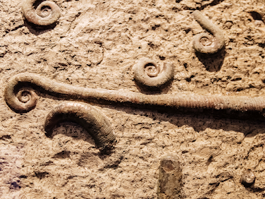
 This marvellous block is filled with Aristoptychites (syn=Arctoptychites) euglyphus (Mojsisovics, 1886) and Daonella sp., oyster-like saltwater clams or bivalves from the Middle Triassic (Ladinian) outcrops in the Botneheia Formation of Spitzbergen, in Edgeøya and Barentsøya, eastern Svalbard, Norway. 

Daonella and Monotis are important species for our understanding of biostratigraphy in the Triassic and are useful as an index fossil. Daonellids preferred soft, soupy substrates and we tend to find them in massive shell beds.

Svalbard is a Norwegian archipelago between mainland Norway and the North Pole. One of the world’s northernmost inhabited areas, it's known for its rugged, remote terrain of glaciers and frozen tundra sheltering polar bears, reindeer and Arctic fox. The Northern Lights are visible during winter, and summer brings the “midnight sun”—sunlight 24 hours a day.

The Botneheia Formation is made up of dark grey, laminated shales coarsening upwards to laminated siltstones and sandstones. South of the type area, the formation shows several (up to four) coarsening-upward units. 

The formation is named for Botneheia Mountain, a mountain in Nordenskiöld Land at Spitsbergen, Svalbard. It has a height of 522 m.a.s.l., and is located south of Sassenfjorden, east of the valley of De Geerdalen. 

Polar Bears, Ursus maritimus
As well as lovely ammonoids and bivalves, we have found ichthyosaur remains. 

It is not a huge surprise. We had been expecting too, but it was not until the early 2000s that the first bones were found.

Two specimens have of ichthyosaur have been recovered. They comprise part of the trunk and the caudal vertebral column respectively. 

Some features, such as the very high and narrow caudal and posterior thoracic neural spines, the relatively elongate posterior thoracic vertebrae and the long and slender haemapophyses tell us that they probably represent a member of the family Toretocnemidae. 

Numerous ichthyosaur finds are known from the underlying Lower Triassic Vikinghøgda Formation and the overlying Middle to Upper Triassic Tschermakfjellet Formation, the new specimens help to close a huge gap in the fossil record of the Triassic ichthyosaurs from Svalbard.

There is a resident research group working on the Triassic ichthyosaur fauna, the Spitsbergen Mesozoic Research Group. Lucky for them, they often find the fossil remains fully articulated — the bones having retained their spacial relationship to one another. Most of their finds are of the tail sections of primitive Triassic ichthyosaurs. In later ichthyosaurs, the tail vertebrae bend steeply downwards and have more of a fish-like look. In these primitive ancestors, the tail looks more eel-like — bending slightly so that the spines on the vertebrae form more of the tail.

Maisch, Michael W. and Blomeier, Dierk published on these finds back in 2009: Neues Jahrbuch für Geologie und Paläontologie - Abhandlungen Band 254 Heft 3 (2009), p. 379 - 384. Nov 1, 2009

The lovely block you see here is in the collections of the deeply awesome John Fam. The image of the Polar Bears, Ursus maritimus, is courtesy of the Fossil Huntress. 

Sunday 24 December 2023

QUENSTEDTOCERAS WITH PATHOLOGY

What you are seeing here is a protuberance extruding from the venter of Quenstedtoceras cf. leachi (Sowerby). It is a pathology in the shell from hosting immature bivalves that shared the seas with these Middle Jurassic, Upper Callovian, Lamberti zone fauna from the Volga River basin. The collecting site is the now inactive Dubki commercial clay quarry and brickyard near Saratov, Russia. 

The site has produced thousands of ammonite specimens. A good 1,100 of those ended up at the Black Hills Institute of Geological Research in Hill City, South Dakota. 

Roughly 1,000 of those are Quenstedtoceras (Lamberticeras) lamberti and the other 100 are a mix of other species found in the same zone. These included Eboraciceras, Peltoceras, Kosmoceras, Grossouvria, Proriceras, Cadoceras and Rursiceras

What is especially interesting is the volume of specimens — 167 Quenstedtoceras (Lamberticeras) lamberti and 89 other species in the Black Hills collection — with healed predation injuries. It seems Quenstedtoceras (Lamberticeras) lamberti are the most common specimens found here and so not surprisingly the most common species found injured. Of the 1,000, 655 of the Quenstedtoceras (Lamberticeras) lamberti displayed some sort of deformation or growth on the shell or had grown in a tilted manner. 

Again, some of the Q. lamberti had small depressions in the centre likely due to a healed bite and hosting infestations of the immature bivalve Placunopsis and some Ostrea

The bivalves thrived on their accommodating hosts and the ammonites carried on, growing their shells right up and over their bivalve guests. This relationship led to some weird and deformities of their shells. They grow in, around, up and over nearly every surface of the shell and seem to have lived out their lives there. It must have gotten a bit unworkable for the ammonites, their shells becoming warped and unevenly weighted. Over time, both the flourishing bivalves and the ammonite shells growing up and over them produced some of the most interesting pathology specimens I have ever seen.    

In the photo here from Emil Black, you can see some of the distorted shapes of Quenstedtoceras sp. Look closely and you see a trochospiral or flattened appearance on one side while they are rounded on the other. 

All of these beauties hail from the Dubki Quarry near Saratov, Russia. The ammonites were collected in marl or clay used in brick making. The clay particles suggest a calm, deep marine environment. One of the lovely features of the preservation here is the amount of pyrite filling and replacement. It looks like these ammonites were buried in an oxygen-deficient environment. 

The ammonites were likely living higher in the water column, well above the oxygen-poor bottom. An isotopic study would be interesting to prove this hypothesis. There's certainly enough of these ammonites that have been recovered to make that possible. It's estimated that over a thousand specimens have been recovered from the site but that number is likely much higher. But these are not complete specimens. We mostly find the phragmocones and partial body chambers. Given the numbers, this may be a site documenting a mass spawning death over several years or generations.

If you fancy a read on all things cephie, consider picking up a copy of Cephalopods Present and Past: New Insights and Fresh Perspectives edited by Neil Landman and Richard Davis. Figure 16.2 is from page 348 of that publication and shows the hosting predation quite well. 

Photos: Courtesy of the deeply awesome Emil Black. These are in his personal collection that I hope to see in person one day. 

It was his sharing of the top photo and the strange anomaly that had me explore more about the fossils from Dubki and the weird and wonderful hosting relationship between ammonites and bivalves. Thank you, my friend!

Saturday 23 December 2023

GOD JUL: TRILACINOCERAS NORVEGICUM

Trilacinoceras norvegicum
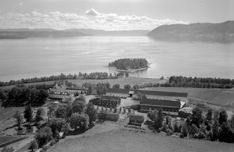
A lovely example of Trilacinoceras norvegicum (Sweet, 1958), a nektonic carnivorous cephalopod from Ordovician outcrops on Helgö Island, Hovindsholm, Helgøya, Lake Mjosa, Norway.

This has been a site of human habitation for more than 5,000 years. Vikings, kings, traders, farmers —  and geologists have walked these fields.

To give that timeframe a bit of context, that's about the age of Skara Brae, the Neolithic settlement in Orkney, Scotland — and older than Stonehenge which clocks in at 3000 BC to 2000 BC and the Great Pyramids — built around 2560 BC.

For my friend, Gale Bishop, that's about 469 km west or a good 7-hour drive from your ancestral home in Ask, just north of Bergen and just south of Knarvik where many of my relatives live — Hei du!

The fossils found here are part of the Engervik Member, Elnes Formation, Aseri, and date back to the Middle Ordovician, 463.5 - 460.9 million years ago. W. C. Sweet did fossil fieldwork here in the 1950s and published a paper on the Middle Ordovician of the Oslo Region, Norway 10. Nautiloid Cephalopods. Norsk Geologisk Tidsskrift 38:1-178.

Deservedly, Sweetoceras boreale is named for him and is one of the most delightful species names of all time. In the 1960s, Yochelson picked up where Sweet left off, continuing the survey of the Middle Ordovician of the Oslo region. I chose this Trilacinoceras for a holiday post because their curly tops remind me of a wee Norwegian gnome, or Nisse from the Norse niðsi, a dear little relative. My Swedish relatives call them Tomte, a throwback to Saint Birgitta of Sweden in the 1300s.

Helgøya is an island in Mjøsa located in the Ringsaker municipality of Hedmark county, Norway. It was formerly a part of the Nes municipality. 

Long before that, it was the ruling centre for the Kings in Hedmark, where bold men and women held great blót celebrations to Odin and planned raids and expansion into Europe and Russia — roughly A.D. 793 — the beginning of the Viking Age.

Today, it is lush and green and easy to explore — or fish. Mjøsa is Norway's largest lake, as well as one of the deepest lakes in Norway and in Europe. 

Battles have been fought on its waters and its depths hold interesting archaeological and paleontological secrets. They also hold a goodly amount of large and tasty trout, pike, perch, burbot and graylings.

Helgøya is the largest freshwater island in Norway at 18.3 km². The island is delightful to explore and home to 32 farms. One of the most beautiful of these is the Hovinsholm manor. You can visit the farm in both summer and winter — both equally beautiful — and enjoy a café, workshop or their Christmas market. They have lush gardens and some very friendly horses you can pet — or spoil with apples, as you do. The property is massive at 2012 acres, divided into grain, potatoes and forest. It has been home to kings and court. It was a monastery in the Middle Ages from the 5th to the 15th century. Today, Tolle Hoel Slotnæs and his wife, Charlotte Holberg Sveinsen own and run the manor with their three daughters.

Hovinsholm, Helgøya, Lake Mjosa, Norway
Helgøya means holy island, in Norwegian. There is a lovely double meaning here and such layered history. The manor, in its various iterations, has been on this site since the 1500s. They had their own Christian manor church until 1612.

On the southern tip of the island, there is an old pagan temple to the Norse Gods, Thor, Frigg, Loki, Hod, Heimdall, Tyr, and Baldur.

Here, farmers of the area would gather at four blót sacrifices a year that followed the seasons — one for each of the winter solstice, spring equinox, summer solstice and autumn equinox. Animals would be sacrificed, their blood splattered on altars, walls and folk around them. Toasts were made. The first was in honour of Thor or Odin, “to the king and victory.” 

Odin, although nominally chief of the gods, was more the god of aristocrats. If a king were toasting, particularly a Danish King, it would be for Odin. If you look at place names in Scandinavia, you'll see him conspicuously absent in favour of Thor, the god of the common man.

When the farmers at Helgøya were shouting Skål, it was likely for Thor. The toasting and drinking continued with cups emptied for Njörd and Freyr and Freyja in the hope of securing a prosperous future. 

Finally, personal pledges (and beer-soaked boasts) would be made to undertake great exploits, Valknut — to die well in battle — and finally to kinsmen laid to rest now drinking with the gods in Valhalla. Weapons, jewellery and tools were thrown into the lake as offerings.

If they were gathering for Jol (Old Norse), Jul (Norwegian) or the Yule blót, they'd also make a large sun wheel (picture a circle with a cross in the middle), carve it up with runes, set it on fire and roll it down a hill. 

It was quite a celebration with the festivities going on for three days and nights. With the formalities over, people did as people do  — drink, sing, boast, play games and find someone to bed down with — Gods be good.

Thor and Odin are still going strong nearly 1,000 years after the end of the Viking Age. You'd think that the old Nordic religion — the belief in the Norse gods — disappeared with the introduction of Christianity. That is not the case. There are still folk in Denmark (Odin-lovers) and Norway (Thor's their guy) who follow the old Norse religion and worship its ancient gods — right down to the splatter.

If you visit Norway at Christmas, Jul (Yule), you'll find much more of the pagan than the Christian in the festivities. King Haakon, old Haakon the Good, Hákon Góði or Håkon den Gode,  moved the Winter Solstice or Yule, Jul, Jol blót over to match up with the Christian holiday on December 25th in his attempts to introduce Christianity in the 10th century. Both traditions are still celebrated but without an overtly religious tone.

Old traditions run deep, animals are still sacrificed (but without all the splatter), bread is baked, houses cleaned, beer is abundant and fires warmth the hearth.

After all the drinking, toasting and feasting at the Jul blót, leftover food was not cleaned up but left overnight for the little relatives. Though shy, Nisse like a good feast and failing to offer them their tithe brings ill-fortune.

But we started this journey together admiring a lovely (and oddly festive) Ordovician cephalopod. Go on, picture him in red and white with a little beard. If you fancy a visit to the Ordovician outcrops, you can find them at Nes-Hamar, Norway. 60.0° N, 11.2° E: paleo-coordinates 33.7° S, 10.3° W. Look for gastropods (five known species) and cephalopods (at least 15 species).

If you'd like to visit the burial mound of Haakon the Good, you'll want to head to Seim, Hordaland, about 10 km north of Knarvik. Good 'ol Haakon may have tried to bring Christianity to Norway but he died full Viking — taking an arrow at the Battle of Fitjar. Many of my rellies live in Knarvik. 

We have enjoyed many a sunny afternoon feasting at the Håkonarspelet summer festivals and exploring Haakon's burial mound at Håkonhaugen in Seim.

If you're more of the manor type, you can stop by Hovinsholm gård, Helgøyvegen 850, 2350 Nes på Hedmarken, Norway. 

If you're curious and want to see the farmstead, head on over to: https://www.skafferiet.no/about. 

If you need to square things up with Odin, you're on your own.

E. L. Yochelson. 1963. The Middle Ordovician of the Oslo Region, Norway. 15. Monoplacophora and Gastropoda. Norsk Geologisk Tidsskrift 43 (2):133-213.

Monday 18 December 2023

TETRAPODS & FIRST NATION FOSSILS

Elpistostege watsoni

In the late 1930s, our understanding of the transition of fish to tetrapods — and the eventual jump to modern vertebrates — took an unexpected leap forward. The evolutionary a'ha came from a single partial fossil skull found on the shores of a riverbank in Eastern Canada. 

Meet the Stegocephalian, Elpistostege watsoni, an extinct genus of finned tetrapodomorphs that lived during the Late Givetian to Early Frasnian of the Late Devonian — 382 million years ago. 

Elpistostege watsoni — perhaps the sister taxon of all other tetrapods — was first described in 1938 by British palaeontologist and elected Fellow of the Royal Society of London, Thomas Stanley Westoll. Westoll's research interests were wide-ranging. He was a vertebrate palaeontologist and geologist best known for his innovative work on Palaeozoic fishes and their relationships with tetrapods. 

As a specialist in early fish, Westoll was asked to interpret that single partial skull roof discovered at the Escuminac Formation in Quebec, Canada. His findings and subsequent publication named Elpistostege watsoni and helped us to better understand the evolution of fishes to tetrapods — four-limbed vertebrates — one of the most important transformations in vertebrate evolution. 

Hypotheses of tetrapod origins rely heavily on the anatomy of but a few tetrapod-like fish fossils from the Middle and Late Devonian, 393–359 million years ago. These taxa — known as elpistostegalians — include Panderichthys, Elpistostege and Tiktaalik — none of which had yet to reveal the complete skeletal anatomy of the pectoral fin. 

Elpistostege watsoni
None until 2010 that is, when a complete 1.57-metre-long articulated specimen was found and described by Richard Cloutier et al. in 2020. 

The specimen helped us to understand the origin of the vertebrate hand. Stripped from its encasing stone, it revealed a set of paired fins of Elpistostege containing bones homologous to the phalanges (finger bones) of modern tetrapods and is the most basal tetrapodomorph known to possess them. 

Once the phalanges were uncovered, prep work began on the fins. The fins were covered in wee scales and lepidotrichia (fin rays). The work was tiresome, taking more than 2,700 hours of preparation but the results were thrilling. 

Origin of the Vertebrate Hand
We could now clearly see that the skeleton of the pectoral fin has four proximodistal rows of radials — two of which include branched carpals — as well as two distal rows organized as digits and putative digits. 

Despite this skeletal pattern — which represents the most tetrapod-like arrangement of bones found in a pectoral fin to date blurring the line between fish and land vertebrates — the fin retained lepidotrichia (those wee fin rays) distal to the radials. 

This arrangement confirmed an age-old question — showing us for the first time that the origin of phalanges preceded the loss of fin rays, not the other way around.

E. watsoni is very closely related to Tiktaalik roseae found in 2004 in the Canadian Arctic — a tetrapodomorpha species also known as a Choanata. These were advanced forms transitional between fish and the early labyrinthodonts playfully referred to as fishapods — half-fish, half-tetrapod in appearance and limb morphology. 

Up to that point, the relationship of limbed vertebrates (tetrapods) to lobe-finned fish (sarcopterygians) was well known, but the origin of major tetrapod features remained obscure for lack of fossils that document the sequence of evolutionary changes — until Tiktaalik. While Tiktaalik is technically a fish, this fellow is as far from fish-like you can be and still be a card-carrying member of the group. 

Tiktaalik roseae
Complete with scales and gills, this proto-fish lacked the conical head we see in modern fish but had a rather flattened triangular head more like that of a crocodile. 

Tiktaalik had scales on its back and fins with fin webbing but like early land-living animals, it had a distinctive flat head and neck. He was a brawny brute. The shape of his skull and shoulder look part fish and part amphibian.

The watershed moment came as Tiktaalik was prepped. Inside Tiktaalik's fins, we find bones that correspond to the upper arm, forearm and even parts of the wrist — all inside a fin with webbing — remarkable! 

Its fins have thin ray bones for paddling like most fish, but with brawny interior bones that gave Tiktaalik the ability to prop itself up, using his limbs for support. I picture him propped up on one paddle saying, "how you doing?" 

Six years after Tiktaalik was discovered by Neil Shubin and team in the ice-covered tundra of the Canadian Arctic on southern Ellesmere Island, a team working the outcrops at Miguasha on the Gaspé Peninsula discovered the only fully specimen of E. watsoni found to date — greatly increasing our knowledge of this finned tantalizingly transitional tetrapodomorph. 

E. watsoni fossils are rare — this was the fourth specimen collected in over 130 years of hunting. Charmingly, the specimen was right on our doorstop — extracted but a few feet away from the main stairs descending onto the beach of Miguasha National Park. 

L'nu Mi’gmaq First Nations of the Gespe’gewa’gi Region

Miguasha is nestled in the Gaspésie or Gespe’gewa’gi region of Canada — home to the Mi’gmaq First Nations who self-refer as L’nu or Lnu. The word Mi’gmaq or Mi’kmaq means the family or my allies/friends in Mi'kmaw, their native tongue (and soon to be Nova Scotia's provincial first language). They are the people of the sea and the original inhabitants of Atlantic Canada having lived here for more than 10,000 years. 

The L'nu were the first First Nation people to establish contact and trade with European explorers in the 16th and 17th centuries — and perhaps the Norse as early as the turn of the Millenium. Sailing vessels filled with French, British, Scottish, Irish and others arrived one by one to lay claim to the region — settling and fighting over the land. As each group rolled out their machinations of discovery, tensions turned to an all-out war with the British and French going head to head. I'll spare you the sordid details but for everyone caught in the crossfire, it went poorly.

North America Map 1775 (Click to Enlarge)
Cut to 1760, the British tipped the balance with their win at the Battle of the Restigouche, the last naval battle between France and England for possession of the North American continent — Turtle Island. 

The bittersweet British victory sparked the American War of Independence. 

For the next twenty years, the L'nu would witness and become embroiled in yet another war for these lands, their lands — first as bystanders, then as American allies, then intimidated into submission by the British Royal Navy with a show of force by way of a thirty-four gun man-of-war, encouraging L'nu compliance — finally culminating in an end to the hostilities with the 1783 Treaty of Paris. 

The peace accord held no provisions for the L'nu, Métis and First Nations impacted. None of these newcomers was Mi'kmaq — neither friends nor allies.

It was to this area some sixty years later that the newly formed Geological Survey of Canada (GSC) began exploring and mapping the newly formed United Province of Canada. Geologists in the New Brunswick Geology Branch traipsed through the rugged countryside that would become a Canadian province in 1867. 

It was on one of these expeditions that the Miguasha fossil outcrops were discovered. They, too, would transform in time to become Miguasha National Park or Parc de Miguasha, but at first, they were simply the promising sedimentary exposures on the hillside across the water —  a treasure trove of  Late Devonian fauna waiting to be discovered.

In the summer of 1842, Abraham Gesner, New Brunswick’s first Provincial Geologist, crossed the northern part of the region exploring for coal. Well, mostly looking for coal. Gesner also had a keen eye for fossils and his trip to the Gaspé Peninsula came fast on the heels of a jaunt along the rocky beaches of Chignecto Bay at the head of the Bay of Fundy and home to the standing fossil trees of the Joggins Fossil Cliffs. 

Passionate about geology and chemistry, he is perhaps most famous for his invention of the process to distil the combustible hydrocarbon kerosene from coal oil — a subject on which his long walks exploring a budding Canada gave him a great deal of time to consider. We have Gesner to thank for the modern petroleum industry. He filed many patents for clever ways to distil the soft tar-like coal or bitumen still in use today.

He was skilled in a broad range of scientific disciplines — being a geologist, palaeontologist, physician, chemist, anatomist and naturalist — a brass tacks geek to his core. Gesner explored the coal exposures and fossil outcrops across the famed area that witnessed the region become part of England and not France — and no longer L'nu.

Following the Restigouche River in New Brunswick through the Dalhousie region, Gesner navigated through the estuary to reach the southern coast of the Gaspé Peninsula into what would become the southeastern coast of Quebec to get a better look at the cliffs across the water. He was the first geologist to lay eyes on the Escuminac Formation and its fossils.

In his 1843 report to the Geologic Survey, he wrote, “...I found the shore lined with a coarse conglomerate. Farther eastward the rocks are light blue sandstones and shales, containing the remains of vegetables. (...) In these sandstone and shales, I found the remains of fish and a small species of tortoise with fossil foot-marks.”

We now know that this little tortoise was the famous Bothriolepis, an antiarch placoderm fish. It was also the first formal mention of the Miguasha fauna in our scientific literature. Despite the circulation of his report, Gesner’s discovery was all but ignored — the cliffs and their fossil bounty abandoned for decades to come. Geologists like Ells, Foord and Weston, and the research of Whiteaves and Dawson, would eventually follow in Gesner's footsteps.

North America Map 1866 (Click to Enlarge)
Over the past 180 years, this Devonian site has yielded a wonderfully diverse aquatic assemblage from the Age of Fishes — five of the six fossil fish groups associated with the Devonian including exceptionally well-preserved fossil specimens of the lobe-finned fishes. 

This is exciting as it is the lobe-finned fishes — the sarcopterygians — that gave rise to the first four-legged, air-breathing terrestrial vertebrates – the tetrapods. 

Fossil specimens from Miguasha include twenty species of lower vertebrates — anaspids, osteostra-cans, placoderms, acanthodians, actinopterygians and sarcopterygians — plus a limited invertebrate assemblage, along with terrestrial plants, scorpions and millipedes.

Originally interpreted as a freshwater lacustrine environment, recent paleontological, taphonomic, sedimentological and geochemical evidence corroborates a brackish estuarine setting — and definitely not the deep waters of the sea. This is important because the species that gave rise to our land-living animals began life in shallow streams and lakes. It tells us a bit about how our dear Elpistostege watsoni liked to live — preferring to lollygag in cool river waters where seawater mixed with fresh. Not fully freshwater, but a wee bit of salinity to add flavour.  

  • Photos: Elpistostege watsoni (Westoll, 1938 ), Upper Devonian (Frasnian), Escuminac formation, Parc de Miguasha, Baie des Chaleurs, Gaspé, Québec, Canada. John Fam, VanPS
  • Origin of the Vertebrate Hand Illustration, https://www.nature.com/articles/s41586-020-2100-8
  • Tiktaalik Illustration: By Obsidian Soul - Own work, CC BY 4.0, https://commons.wikimedia.org/w/index.php?curid=47401797

References & further reading:

  • From Water to Land: https://www.miguasha.ca/mig-en/the_first_discoveries.php
  • UNESCO Miguasha National Park: https://whc.unesco.org/en/list/686/
  • Office of L'nu Affairs: https://novascotia.ca/abor/aboriginal-people/
  • Cloutier, R., Clement, A.M., Lee, M.S.Y. et al. Elpistostege and the origin of the vertebrate hand. Nature 579, 549–554 (2020). https://doi.org/10.1038/s41586-020-2100-8
  • Daeschler, E. B., Shubin, N. H. & Jenkins, F. A. Jr. A Devonian tetrapod-like fish and the evolution of the tetrapod body plan. Nature 440, 757–763 (2006).
  • Shubin, Neil. Your Inner Fish: A Journey into the 3.5 Billion History of the Human Body.
  • Evidence for European presence in the Americas in AD 1021: https://www.nature.com/articles/s41586-021-03972-8

Saturday 14 October 2023

AN UNLIKELY RHINOCEROS AND THE GREAT DEPRESSION

The Miocene pillow basalts from the Lake Roosevelt National Recreation Area of central Washington hold an unlikely fossil. 

What looks to be a rather unremarkable ballooning at the top of a cave is actually the mould of a small rhinoceros, preserved by sheer chance as its bloated carcass sunk to the bottom of a shallow lake just prior to a volcanic explosion.

We have known about this gem for a long while now. The fossil was discovered by hikers back in 1935 and later cast by the University of California palaeontologists in 1948. 

The Dirty Thirties & The Great Depression

These were the Dirty Thirties and those living in Washington state were experiencing the Great Depression along with the rest of the country and the world. Franklin D. Roosevelt was President of the United States, navigating the States away from laissez-faire economics. 

Charmingly, Roosevelt would have his good name honoured by this same park in April of 1946, a few years before researchers at Berkeley would rekindle interest in the site.

Both hiking and fossil collecting was a fine answer to these hard economic times and came with all the delights of discovery with no cost for natural entertainment. And so it was that two fossil enthusiast couples were out looking for petrified wood just south of Dry Falls on Blue Lake in Washington State. 

While searching the pillow basalt, the Frieles and Peabodys came across a large hole high up in a cave that had the distinctive shape of an upside-down rhinoceros.

This fossil is interesting in all sorts of ways. First, we so rarely see fossils in igneous rocks. As you might suspect, both magma and lava are very hot. Magma, or molten rock, glows a bright red/orange as it simmers at a toasty 700 °C to 1300 °C (or 1300 °F to 2400 °F) beneath the Earth's surface.

A Rhinoceros Frozen in Lava

During the late Miocene and early Pliocene, repeated basaltic lava floods engulfed about 63,000 square miles of the Pacific Northwest over a period of ten to fifteen million years. After these repeated bathings the residual lava accumulated to more than 6,000 feet.

As magma pushes up to the surface becoming lava, it cools to a nice deep black. In the case of our rhino friend, this is how this unlikely fellow became a fossil. Instead of vaporizing his remains, the lava cooled relatively quickly preserving his outline as a trace fossil and remarkably, a few of his teeth, jaw and bones. The lava was eventually buried then waters from the Spokane Floods eroded enough of the overburden to reveal the remains once more.

Diceratherium tridactylum (Marsh, 1875)
Diceratherium (Marsh, 1875) is known from over a hundred paleontological occurrences from eighty-seven collections.

While there are likely many more, we have found fossil remains of Diceratherium, an extinct genus of rhinoceros, in the Miocene of Canada in Saskatchewan, China, France, Portugal, Switzerland, and multiple sites in the United States.

He has also been found in the Oligocene of Canada in Saskatchewan, and twenty-five localities in the United States — in Arizona, Colorado, Florida, Nebraska, North Dakota, Oregon, South Dakota, Washington and Wyoming.  

Diceratherium was a scansorial insectivore with two horns and a fair bit of girth. He was a chunky fellow, weighing in at about one tonne (or 2,200 lbs). That is about the size of a baby Humpback Whale or a walrus.

Back in the Day: Washington State 15 Million-Years Ago

He roamed a much cooler Washington state some 15 million years ago. Ice dams blocked large waterways in the northern half of the state, creating reservoirs. Floodwaters scoured the eastern side of the state, leaving scablands we still see today. In what would become Idaho, volcanic eruptions pushed through the Snake River, the lava cooling instantly as it burst to the surface in a cloud of steam. 

By then, the Cascades had arrived and we had yet to see the volcanic eruptions that would entomb whole forests up near Vantage in the Takama Canyon of Washington state. 

Know Before You Go

You are welcome to go see his final resting site beside the lake but it is difficult to reach and comes with its own risks. Head to the north end of Blue Lake in Washington. Take a boat and search for openings in the cliff face. You will know you are in the right place if you see a white "R" a couple hundred feet up inside the cliff. Inside the cave, look for a cache left by those who've explored here before you. Once you find the cache, look straight up. That hole above you is the outline of the rhino.

If you don't relish the thought of basalt caving, you can visit a cast of the rhino at the Burke Museum in Seattle, Washington. They have a great museum and are pretty sporting as they have built the cast sturdy enough for folk to climb inside. 

The Burke Museum 

The Burke Museum recently underwent a rather massive facelift and has re-opened its doors to the public. You can now explore their collections in the New Burke, a 113,000 sq. ft. building at 4300 15th Ave NE, Seattle, WA 98105, United States. Or visit them virtually, at https://www.burkemuseum.org/

Photo: Robert Bruce Horsfall - https://archive.org/details/ahistorylandmam00scotgoog, Public Domain, https://commons.wikimedia.org/w/index.php?curid=12805514

Reference: Prothero, Donald R. (2005). The Evolution of North American Rhinoceroses. Cambridge University Press. p. 228. ISBN 9780521832403.

Reference: O. C. Marsh. 1875. Notice of new Tertiary mammals, IV. American Journal of Science 9(51):239-250

Lincoln, Roosevelt and Recovery from The Great Depression

Rural Tennessee has electricity for the same reason Southeast Alaska has totem parks. In order to help the nation recover from The Great Depression, President Franklin D. Roosevelt, created a number of federal agencies to put people to work. From 1938-1942 more than 200 Tlingit and Haida men carved totem poles and cleared land for the Civilian Conservation Corps in an effort to create “totem parks” the federal government hoped would draw travelers to Alaska.

This odd intersection of federal relief, Alaska Native art and marketing is the subject of Emily L. Moore’s book “Proud Raven, Panting Wolf: Carving Alaska’s New Deal Totem Parks.”

This effort to bring poles out of abandoned villages includes the Lincoln Pole being moved to Saxman Totem Park by the Civilian Conservation Corps (CCC), who established the Saxman Totem Park in 1938.  

The top carving on the Lincoln Pole bears a great likeness of Abraham Lincoln. According to the teachings of many Tlingit elders, this carving was meant to represent the first white man seen in Tlingit territory in the 18th century.  

A century later, in the 1880s, one of my ancestors from the Gaanax.ádi Raven clan of the Tongass Tlingit commissioned the pole to commemorate our ancestor's pride to have seen this first white man—which has become a Gaanax.ádi crest—using a photograph of Abraham Lincoln as the model. 

It is important not only for these various readings of the crests but also because it claims Gaanax.ádi clan territory before the first Europeans and budding Americans came to these shores—territory that Tlingit carvers who were re-carving the pole in the 1940s were trying to assert to the U.S. government as sovereign land.

Interestingly, another pole in that same park is the Dogfish Pole, carved for Chief Ebbits Andáa, Teikweidi, Valley House. The Chief Ebbits Memorial Pole—the Dogfish Kootéeyaa Pole—was raised in 1892 in Old Tongass Village in honour of a great man, Head Chief of the Tongass and my ancestor. It was then moved, re-carved and re-painted at Saxman Totem Park in 1938 as part of Roosevelt's program—and it due to be re-carved again this year. 

It tells the story of his life and the curious way he became Ebbits as he was born Neokoots. He met and traded with some early American fur traders. One of those traders was a Mister Ebbits. The two became friends and sealed that friendship with the exchanging of names.  

If you would like to read more about that pole and others, I recommend, The Wolf and the Raven, by anthropologist Viola Garfield and architect Linn Forrest (my talented cousin), published in 1961 and still in print as I ordered a copy for a friend just this year.

Tuesday 1 August 2023

SACRED EARTH: HARRISON LAKE FOSSILS

Located three hours east of Vancouver, most folks head to Harrison Lake to enjoy its crisp waters, soak in the hot springs, camp or four-wheel-drive immersed in rugged scenery, or look for the elusive Sasquatch reported to live in the area. 

But there are some who come to Harrison Lake and miss the town entirely. Instead, they favour the upper west side of the lake and the fossiliferous bounty found here.

Indeed, this is the perfect location for local citizen scientists to strut their stuff. Harrison is a perfect family day trip, where you can discover wonderful marine fossil specimens as complete or partially crushed fossilized shells embedded in rock. 

It is truly amazing that we can find them at all. These beauties range in age from Jurassic to Cretaceous, with most being Lower Callovian, meaning the ammonites here swam our ancient oceans more than 160 million years ago. 

The area around Harrison Lake has been home to the Sts’ailes, a sovereign Coast Salish First Nation for thousands of years. Sts’ailes’ means, “the beating heart,” and it sums up this glorious wilderness perfectly. They describe their ancient home as Xa’xa Temexw or Sacred Earth. 

With the settling of Canada, Geologists began exploring the area in the 1880s, calling upon the Sts’ailes to help them look for coal and a route for the Canadian Pacific Railway. Coal was the aim, but happily, they also found fossils. Sacred Earth, indeed.  

Belemnite Fossils
In my favourite outcrops, you can find large, smooth inflated Jurassic ammonites along with their small grey and brown cousins. 

Further up the road, you will see Cretaceous cigar-shaped squid-like cephalopods called Belemnites, and the bivalve (clam) Buchia — gifts deposited by glaciers. Here are the most common.

Ammonites

Almost all of the ammonite specimens found near Harrison Lake are the toonie sized Cadoceras (Paracadoceras) tonniense with well-preserved outer whorls but flattened inner whorls. We find semi-squished elliptical specimens here, too. If you see a large, smooth, inflated grapefruit-sized ammonite, you are holding a rare prize — a Cadoceras comma ammonite, the macroconch or female of the species.  

Ammonites were predatory, squid-like creatures that lived inside coil-shaped shells. Like other cephalopods, ammonites had sharp, beak-like jaws inside a ring of squid-like tentacles that extended from their shells. They used these tentacles to snare prey — plankton, vegetation, fish and crustaceans — similar to the way a squid or octopus hunts today.

Within their shells, ammonites had a number of chambers called septa filled with gas or fluid, and they were interconnected through a wee air tube. By pushing air in or out, they were able to control their buoyancy. 

These small but mighty marine predators lived in the last chamber of their shell and continuously built new shell material as they grew. As they added each new chamber, they would move their squid-like body down to occupy the final outside chamber.

Interestingly, ammonites from Harrison Lake are quite similar to the ones found within the lower part of the Chinitna Formation near Cook Inlet, Alaska, and Jurassic Point, Kyuquot, on the west coast of Vancouver Island — some of the most beautiful places on Earth. 

Buchia (bivalve) Clams

The bivalve or clam Buchia are commonly found at Harrison Lake. You will see them cemented together en masse. . They populated Upper Jurassic–Lower Cretaceous waters like a team sport. When they thrived, they really thrived, building up large coquinas of material. Large boulders of Buchia cemented together en masse hitched a ride with the glaciers and were deposited around Harrison Lake. Some kept going and we find similar erratics or glacier-deposited boulders as far south as Washington state. 

Buchia is used as Index Fossils. Index fossils help us to figure out the age of the rock we are looking at because they are abundant, populate an area en masse, and then die out quickly. In other words, they make it easy to identify a geologic time span.

So what does this mean to you? Now, when you are out and about with friends and discover rocks with Buchia, or made entirely of Buchia, you can say, “Oh, this looks to be Upper Jurassic or Lower Cretaceous. Come take a look! We're likely the first to lay eyes on this little clam since dinosaurs roamed the Earth.” 

Fossil Collecting at Harrison Lake Fossil Field Trip — Getting there

This Harrison Lake site is a great day trip from Vancouver or the Fraser Valley. You will need a vehicle with good tires for travel on gravel roads. Search out the route ahead of time and share your trip plan with someone you trust. If you can pre-load the Google Earth map of the area, you will thank yourself. 

Heading east on from Vancouver, it will take you 1.5-2 hours to reach Harrison Mills. 

Access Forestry Road #17 at the northeast end of the parking lot from the Sasquatch Inn at 46001 Lougheed Hwy, Harrison Mills. From there, it will take about an hour to get to the site. Look for signs for the Chehalis River Fish Hatchery to get you started. 

Drive 30 km up Forestry Road #1, and stop just past Hale Creek at 49.5° N, 121.9° W (paleo-coordinates 42.5° N, 63.4° W) on the west side of Harrison Lake. You will see Long Island to your right. 

The first of the yummy fossil exposures are just north of Hale Creek on the west side of the road. Keep in mind that this is an active logging road, so watch your kids and pets carefully. Everyone should be wearing something bright so they can be easily spotted.

How to Spot the Fossils

The fossils here are easily collected—look in the bedrock and in the loose material that gathers in the ditches. Specimens will show up as either dark grey, grey-brown or black. Look for the large, dark-grey boulders the size of smart cars packed with Buchia. 

And while you are at it, be on the lookout for anything that looks like bone. This site is also ripe for marine reptiles—think plesiosaur, mosasaur and elasmosaur. As a citizen scientist and budding palaeontologist, you might just find something new!

What to Know Before You Go

Fill your gas tank and pack a tasty lunch. As with all trips into British Columbia's wild places, dress for the weather. You will need hiking boots, rain gear, gloves, eye protection, and a good geologic hammer and rock (cold) chisel. 

Wear bright clothing and keep your head covered. Slides are common, and you may start a few if you hike the cliffs. If you are with a group, those collecting below may want to consider hardhats in case of rockfall — chunks of rock the size of your fist up to the size of a grapefruit. They pack a punch. 

Bring a colourful towel or something to put your keepers on. Once you set rock down, it can be hard to find again given the terrain. I take the extra precaution of spraying the ends of my hammers and chisels with yellow fluorescent paint, as I have lost too many in the field. You will also want to bring a camera for the blocks of Buchia that are too big to carry home. 

Identifying Your Treasures

When you have finished for the day, compare your treasures to see which ones you would like to keep. In British Columbia, you are a steward of the fossil, which means they belong to the province, but you can keep them safe. You are not allowed to sell or ship them outside British Columbia without a permit. 

Once you get home, wash and identify your finds. Harrison Lake does not have a large variety of fossil fauna, so this should not be difficult. If your find is coiled and round, it is an ammonite. If it is long and straight, it is a belemnite. And if it looks like a wee fat baby oyster, it is Buchia. This is not always true, but mostly true.

What about collecting fossils in all seasons?. Everyone has a preference. I prefer not to collect in the snow, but I have done it. While sunny days are lovely, it can also be easier to see the specimens when the rock is wet. So, do we do this in the rain? Heck, yeah! 

In torrential rain? 

Yes — once you are hooked, but for your casual friends or the kiddos, the answer is likely no. Choose your battles. They may come with you, but a cold day getting soaked is no fun. 

In time, you will find your inner fossil geek — probably with your first find. And that's just the tip of the iceberg. First, it will be you, then your kids, your friends and then your neighbour. Once you start, it is easy to get hooked. Fossil addiction is real, and the only cure is to get out there and do it some more. You've got this!

References and further information:

A. J. Arthur, P. L. Smith, J. W. H. Monger and H. W. Tipper. 1993. Mesozoic stratigraphy and Jurassic palaeontology west of Harrison Lake, southwestern British Columbia. Geological Survey of Canada Bulletin 441:1-62

R. W. Imlay. 1953. Callovian (Jurassic) ammonites from the United States and Alaska Part 2. The Alaska Peninsula and Cook Inlet regions. United States Geological Survey Professional Paper 249-B:41-108

An overview of the tectonic history of the southern Coast Mountains, British Columbia; Monger, J W H; in, Field trips to Harrison Lake and Vancouver Island, British Columbia; Haggart, J W (ed.); Smith, P L (ed.). Canadian Paleontology Conference, Field Trip Guidebook 16, 2011 p. 1-11 (ESS Cont.# 20110248).


Thursday 8 June 2023

VANCOUVER ISLAND'S FABULOUS FOSSILS: TRENT RIVER PALAEONTOLOGY

Dan Bowen, Chair, VIPS, Trent River
The rocks that make up the Trent River on Vancouver Island are on the move. They were laid down near of the equator as small, tropical islands. They rode across the Pacific heading north and slightly east over the past 85 million years to where we find them today.

The Pacific Plate is an oceanic tectonic plate that lies beneath the Pacific Ocean. And it is massive. At 103 million km2 (40 million sq mi), it is the largest tectonic plate and continues to grow fed by volcanic eruptions that piggyback onto its trailing edge.

This relentless expansion pushes the Pacific Plate into the North American Plate. The pressure subducts it beneath our continent where it then melts back into the earth. Plate tectonics are slow but powerful forces. 

The island chains that rode the plates across the Pacific smashed into our coastline and slowly built the province of British Columbia. And because each of those islands had a different origin, they create pockets of interesting and diverse geology.

It is these islands that make up the Insular Belt — a physio-geological region on the northwestern North American coast. It consists of three major island groups — and many smaller islands — that stretches from southern British Columbia up into Alaska and the Yukon. These bits of islands on the move arrived from the Late Cretaceous through the Eocene — and continues to this day.

The rocks that form the Insular Superterrane are allochthonous, meaning they are not related to the rest of the North American continent. The rocks we walk over along the Trent River are distinct from those we find throughout the rest of Vancouver Island, Haida Gwaii, the rest of the province of British Columbia and completely foreign to those we find next door in Alberta.

To discover what we do find on the Trent takes only a wee stroll, a bit of digging and time to put all the pieces of the puzzle together. The first geological forays to Vancouver Island were to look for coal deposits, the profitable remains of ancient forests that could be burned to the power industry.

Jim Monger and Charlie Ross of the Geological Survey of Canada both worked to further our knowledge of the complex geology of the Comox Basin. They were at the cutting edge of west coast geology in the 1970s. It was their work that helped tease out how and where the rocks we see along the Trent today were formed and made their way north.

We know from their work that by 85 million years ago, the Insular Superterrane had made its way to what is now British Columbia. 

The lands were forested much as they are now but by extinct genera and families. The fossil remains of trees similar to oak, poplar, maple and ash can be found along the Trent and Vancouver Island. We also see the lovely remains of flowering plants such as Cupanities crenularis, figs and breadfruit.

Heading up the river, you come to a delineation zone that clearly marks the contact between the dark grey marine shales and mudstones of the Haslam Formation where they meet the sandstones of the Comox Formation. Fossilized material is less abundant in the Comox sandstones but still contains some interesting specimens. Here you begin to see fossilized wood and identifiable fossil plant material.

Further upstream, there is a small tributary, Idle Creek, where you can find more of this terrestrial material in the sandy shales. As you walk up, you see identifiable fossil plants beneath your feet and jungle-like, overgrown moss-covered, snarly trees all around you.

Walking west from the Trent River Falls at the bottom, you pass the infamous Ammonite Alley, where you can find Mesopuzosia sp. and Kitchinites sp. of the Upper Cretaceous (Santonian), Haslam Formation. Minding the slippery green algae covering some of the river rocks, you can see the first of the Polytychoceras vancouverense zone.

Continuing west, you reach the first of two fossil turtle sites on the river — amazingly, one terrestrial and one marine. If you continue, you come to the Inland Island Highway.

The Trent River has yielded some very interesting marine specimens, and significant terrestrial finds. We have found a wonderful terrestrial helochelydrid turtle, Naomichelys speciosa, and the caudal vertebrae of a Hadrosauroid dinosaur. Walking down from the Hadrosaur site you come to the site of the fossil ratfish find — one of the ocean's oddest fish.

Ratfish, Hydrolagus Collie, are chimaera found in the north-eastern Pacific Ocean today. The fossil specimen from the Trent would be considered large by modern standards as it is a bruiser in comparison to his modern counterparts. 

This robust fellow had exceptionally large eyes and sex organs that dangled enticingly between them. You mock, but there are many ratfish who would differ. While inherently sexy by ratfish standards, this fellow was not particularly tasty to their ancient marine brethren (or humans today) — so not hugely sought after as a food source or prey.

A little further again from the ratfish site we reach the contact of the two Formations. The rocks here have travelled a long way to their current location. With them, we peel away the layers of the geologic history of both the Comox Valley and the province of British Columbia.

The Trent River is not far from the Puntledge, a river whose banks have also revealed many wonderful fossil specimens. The Puntledge is also the name used by the K'ómoks First Nation to describe themselves. They have lived here since time immemorial. Along with Puntledge, they refer to themselves as Sahtloot, Sasitla and Ieeksun.

References: Note on the occurrence of the marine turtle Desmatochelys (Reptilia: Chelonioidea) from the Upper Cretaceous of Vancouver Island Elizabeth L. Nicholls Canadian Journal of Earth Sciences (1992) 29 (2): 377–380. https://doi.org/10.1139/e92-033; References: Chimaeras - The Neglected Chondrichthyans". Elasmo-research.org. Retrieved 2017-07-01.

Directions: If you're keen to explore the area, park on the side of Highway 19 about three kilometres south of Courtenay and hike up to the Trent River. Begin to look for parking about three kilometres south of the Cumberland Interchange. There is a trail that leads from the highway down beneath the bridge which will bring you to the Trent River's north side.

Sunday 21 May 2023

OKANAGAN HIGHLAND FOSSIL LOCALITIES

Fossils from the Okanagan Highlands, an area centred in the Interior of British Columbia, provide important clues to our ancient climate. 

Okanagan Highlands refers to an arc of Eocene lakebed sites that extend from Smithers in the north, down to the fossil site of Republic Washington. 

The grouping includes the fossil sites of Driftwood Canyon, Quilchena, Allenby, Tranquille, McAbee, Princeton and Republic.

These fossil sites range in time from Early to Middle Eocene, and the fossil they contain give us a snapshot of what was happening in this part of the world because of the varied plant fossils they contain.

We can infer the difference in climates between the sites. McAbee was not as warm as some of the other Middle Eocene sites, a fact inferred by what we see and what is conspicuously missing. In looking at the plant species, it has been suggested that the area of McAbee had a more temperate climate, slightly cooler and wetter than other Eocene sites to the south at Princeton, British Columbia and Republic and Chuckanut, Washington. Missing are the tropical Sabal (palm), seen at Princeton and the impressive Ensete (banana) and Zamiaceae (cycad) found at Republic in north-central Washington, in the Swauk Formation near Skykomish and the Chuckanut Formation of northern Washington state.

Saturday 11 March 2023

OLENELLUS OF THE EAGER: CRANBROOK, BRITISH COLUMBIA

The partial specimen you see here is an Olenellus trilobite from the Eager Formation near Cranbrook, British Columbia.

It was exciting to crack open the rock and find a specimen, many specimens, more than half a billion years old. It is something we so rarely do but the opportunity is all around us in the many sedimentary rocks that outcrop near the surface around the globe. 

Near Cranbrook, the Eager Formation outcrops at several locations just outside of town. This particular lovely is from the Rifle Range locality and is in my collection at 98-CR-EF042 — meaning it was collected in 1998 and the 42nd find of the day. This is a prolific site and with diligent collecting, you can find many wonderful specimens of scientific and aesthetic value in the course of a day.

The Rifle Range locality sits on the Silhouette Rifle Range — which is literally on a rifle range where folks go to shoot at things.

The fossils we find here are just a shade older than those found at the Burgess Shale. Burgess is Middle Cambrian and the species match the Eager fauna one for one but the Eager fauna are much less varied. 

Olenellus is an extinct genus of redlichiid trilobites, early arthropods, that litter this glorious Cambrian site. Olenellus is the only genus currently recognised in the subfamily Olenellinae. The sister group called the Mesonacinae consists of the genera Mesonacis and Mesolenellus.

Olenellus range in size but are about 5 centimetres or 2.0 inches long on average. They lived during the Botomian and Toyonian stages, Olenellus-zone, 522 to 510 million years ago, in what is currently North America in what was part of the paleocontinent of Laurentia.

Olenellus are both common in and restricted to Early Cambrian rocks — 542 million to 521 million years old — and thus a useful Index Fossil for the Early Cambrian. 

Olenellus had a well-developed head, large and crescentic eyes, and a poorly developed, small tail. The fellow you see had a bit of his tail crushed as he turned to stone.

Trilobites were amongst the earliest fossils with hard skeletons. While they are extinct today, they were the dominant life form at the beginning of the Cambrian and it is what we find as the primary fossil in the fauna of the Eager Formation. 

A slightly crushed lingulida brachiopod
The Eager Formation has produced many beautifully preserved Wanneria, abundant Olellenus and a handful of rare and treasured Tuzoia and Anomalocaris claws. The shale matrix lends itself to amazing preservation. 

The specimens of Wanneria from here are impressively large. Some are up to thirteen centimetres long and ten centimetres wide. You find a mixture of complete specimens and head impressions from years of perfectly preserved moults.

From July 21 to 31, 2015, the Royal Ontario Museum (ROM), under the direction of Dr. Jean-Bernard Caron carried out a palaeontological dig at an exposure of the Eager Formation that outcrops between Cranbrook and  Fort Steele in the East Kootenay Region of British Columbia. 

The team included David George (APS), Dr. Bob Gaines (Pomona College), Dr. Jean-Bernard Caron (ROM), Dr. Gabriela Mangano (University of Saskatchewan), Maryam Akrami (ROM), Darrell Nordby (APS), Joe Moysiuk (University of Toronto), and local, Guy Santucci (APS and project field co-ordinator), and Dr. Mark Webster (University of Chicago).

Dr. Caron was interested in the fauna of the Eager Formation as there is an overlap with the Burgess Shale species — the Eager is a window into time 513 million years ago — 8 million years earlier than the Burgess. 

Lower Cambrian Brachiopod
They found the usual suspects, including multiple specimens of Wanneria dunnae and Olenellus ricei along with the rarer genus Mesonacis, in addition to specimens of the elusive Tuzoia

They also found a block with at least 112 individual trilobites (mostly moulted cephalons) of Olenellus ricei and Wanneria dunnae

The most exciting of their finds included a sponge, Anomalocaris, Morania (a cyanobacterial growth), and a hyolithid similar to the Burgess Haplophrentis.

They also found many trace fossils. There was a particularly fetching 30 cm trace fossil, likely from a large Wanneria, that I hope Dr. Mángano or one of her graduate students lend their gaze — Gabriela is a particularly good writer. 

She is co-editor of Palaios, in addition to being a member of the editorial board of a number of journals, including Journal of Paleontology, Paleontologia Electronica, Palaeogeography Palaeoclimatology Palaeoecology, Ameghiniana, and Revista Brasilera de Paleontologia. Gabriela is a member of the Scientific Board of the UNESCO International Geoscience Program (IGCP), member of the SEPM Board, and Treasurer of the International Ichnological Association. Add all that to extensive fieldwork and supervising over fifteen graduate students and postdoctoral fellows — she's an amazing woman.

Their excavation of the site was thorough — reducing all of the potentially fossil-bearing strata to pieces the size or smaller than a dinner plate. The 2015 team used a backhoe to take off the weathered top layer and get down to the bedrock below.

It has been six years since their visit and we will hopefully see some worthy publications from their efforts. There had been talk of multiple publications stemming from the spectrum of species, a comparison to the Burgess fauna and papers on the trace fossils. I checked in with Joe Moysuik from the University of Toronto who had been on the dig in 2015. To his knowledge, no new papers have yet to be published — though, Caron has been a busy bee on a sexy new nektobenthic suspension feeder from the Burgess material. I am rather hoping their team sorts out the naming of some of the species and gets them to publication so we can finally put them to bed.

Days after my correspondence with Moysuik, Chris Jenkins, a Cranbrook local and huge contributor to our knowledge of Upper Cambrian trilobites, shared an exciting find. 

He and Don Askew had ventured out together for their first fossil field trip of 2021 — and made a rather auspicious start to the year. 

The two had met some 10 years previous when Don, an avid outdoorsman and Jenkins' neighbour, had wandered over to see what all the rocks were about in Jenkins' yard. 

Tales of trilobites and a lifelong friendship ensued. It was also the beginnings of shared fieldwork. This time, it was to outcrops of the Eager Formation just outside of Cranbrook. Together, the two unearthed a three-foot-wide band of Eager Formation bedrock. Not unusual in and of itself — but instead of the usual trilobites — this rock revealed several varieties of Lower Cambrian brachiopods. 

Jenkins shared photos of at least three different types of brachiopods — potentially new fauna for the Eager. Although they superficially resemble the molluscs that make modern seashells, they are not related. Brachiopods were the most abundant and diverse fossil invertebrates of the Paleozoic — over 4500 genera known; the number of species is far greater. So, naturally, we had expected to find brachiopods in the Eager Formation as they were abundant in Lower Cambrian seas — but so far they had eluded us.

And, interestingly, the rock containing the brachiopods is devoid of any trilobite specimens — not a one. Have they found a wee slip of the Eager Formation that records a nearshore environment or have they stumbled across a segment that records another time period altogether?

The brachiopods you see in the photos above are roughly 1/4 inch to 3/4 inches. Should Caron and team return to the site, these new brachiopods will be of great interest as they look to rewrite the geology and palaeontology of the site and region.