Tuesday, 6 September 2022

INUKTITUT: STEWARDS OF OUR NORTHERN WORLD

Nunatsiarmiut Mother and Child, Baffin Island, Nunavut
Warm light bathes this lovely Nunatsiarmiut mother and child from Baffin Island, Nunavut. 

They speak Inuktitut, the mother tongue of the majority of the Nunatsiarmiut who call Baffin Island home. 

Baffin is the largest island in the Arctic Archipelago in the territory of Nunavut in Canada's far north. 

As part of the Qikiqtaaluk Region of Nunavut, Baffin Island is home to a constellation of remote Inuit communities each with a deep cultural connection to the land — Iqaluit, Pond Inlet, Pangnirtung, Clyde River, Arctic Bay, Kimmirut and Nanisivik. 

The ratio of Inuit to non-Inuit here is roughly three to one and perhaps the reason why the Inuktitut language has remained intact and serves as the mother tongue for more than 36,000 residents. Inuktitut has several subdialects — these, along with a myriad of other languages — are spoken across the north.  

If you look at the helpful visual below you begin to get a feel for the diversity of these many tongues. The languages vary by region. There is the Iñupiaq of the Inupiatun/Inupiat; Inuvialuktun of the Inuinnaqtun, Natsilingmiutut, Kivallirmiutut, Aivilingmiutut, Qikiqtaaluk Uannanganii and Siglitun. Kalaallisut is spoken by many Greenlandic peoples though, in northwest Greenland, Inuktun is the language of the Inughuit.

We use the word Inuktitut when referring to a specific dialect and inuktut when referring to all the dialects of Inuktitut and Inuinnaqtun.

Northern Language Map (Click to Enlarge)
Should you travel to the serene glacier-capped wilds and rolling tundra of our far north, you will want to dress for the weather and learn a few of the basics to put your best mukluk shod feet forward. 

The word for hello or welcome in Inuktitut is Atelihai — pronounced ahh-tee-lee-hi. And thank you is nakurmiik, pronounced na-kur-MIIK.  

Perhaps my favourite Inuktitut expression is Naglingniq qaikautigijunnaqtuq maannakautigi, pronounced NAG-ling-niq QAI-kau-ti-gi-jun-naqtuq MAAN-na-KAU-ti-gi. This tongue-twister is well worth the linguistic challenge as it translates to love can travel anywhere in an instant. Indeed it can.

You have likely seen or heard the word Eskimo used in older books to refer to the Inuit, Iñupiat, Kalaallit or Yupik. This misnomer is a colonial term derived from the Montagnais or Innu word ayas̆kimewnetter of snowshoes. It is a bit like meeting a whole new group of people who happen to wear shoes and referring to them all as cobblers — not as a nickname, but as a legal term to describe populations from diverse communities disregarding the way each self-refer. 

Inukshuk / Inuksuk Marker Cairn
For those who identify as Inupiaq or Yupik, the preferred term is Inuit meaning people — though some lingering use of the term Eskimo lives on. The Inuit as a group are made up of many smaller groups. 

The Inuit of Greenland self-refer as Kalaallit or Greenlanders when speaking Kalaallisut. The Inupiat of Alaska, or real people, use Yupik as the singular for real person and yuk to simply mean person.

When taken all together, Inuit is used to mean all the peoples in reference to the Inuit, Iñupiat, Kalaallit and Yupik. Inuit is the plural of inuk or person

You likely recognize this word from inuksuk or inukshuk, pronounced ih-nook-suuk — the human-shaped stone cairns built by the Inuit, Iñupiat, Kalaallit, Yupik, and other peoples of the Arctic regions of northern Canada, Greenland, and Alaska — helpful reference markers for hunters and navigation. The word inuksuk means that which acts in the capacity of a human, combining inuk or person and suk, to substitute

A World of Confusion

You may be disappointed to learn that our northern friends do not live in igloos. I remember answering the phone as a child and the fellow calling was hoping to speak to my parents about some wonderful new invention perfect for use in an igloo. He was disappointed to hear that I was standing in a wooden house with the standard four walls to a room and a handy roof topping it off. "Well, what about your neighbours? Surely some of them live in igloos..." It seems that some of the atlases in circulation at the time, and certainly the one he was looking at, simply blanketed everything north of the 49th parallel in a snowy white. His clearly showed an igloo sitting proudly in the centre of the province.

My cousin Shawn brought one such simplified book back from his elementary school in California. British Columbia had a nice image of a grizzly bear and a wee bit further up, a polar bear grinned smugly. British Columbia's beaver population would be sad to know that they did not inhabit the province though there were two chipper beavers with big bright smiles — one in Ontario and another gracing the province of Quebec. Further north, where folk do build igloos, they were curiously lacking. 

Igloos are used for winter hunting trips much the same way we use tents for camping. The Inuit do not have fifty words for snow — you can thank the ethnographer Franz Boas for that wee fabrication — but within the collective languages of the frozen north there are more than fifty words to describe it. And kisses are not nose-to-nose. To give a tender kiss or kunik to a loved one, you press your nose and upper lip to their forehead or cheek and rub gently. 

Fancy to try a wee bit of Inuktitut yourself? This link will bring you to a great place to start: https://inhabitmedia.com/inuitnipingit/

Inuit Language Map:  By Noahedits - Own work, CC BY-SA 4.0. If you want to the image full size, head to this link: https://commons.wikimedia.org/w/index.php?curid=85587388

Monday, 5 September 2022

BARNACLES: KWIT'A'A

One of the most interesting and enigmatic little critters we find at the seashore are barnacles. They cling to rocks deep in the sea and at the waters' edge, closed to our curiosity, their domed mounds like little closed beaks shut to the water and the world.

They choose their permanent homes as larvae, sticking to hard substrates that will become their permanent homes for the rest of their lives. It has taken us a long time to find how they actually stick or what kind of "glue" they were using.

Remarkably, the barnacle glue sticks to rocks in a similar way to how red cells bind together. Red blood cells bind and clot with a little help from some enzymes. 

These work to create long protein fibres that first blind, clot then form a scab. The mechanism barnacles use, right down to the enzyme, is very similar. That's especially interesting as about a billion years separate our evolutionary path from theirs.

So, with the help of their clever enzymes, they can affix to most anything – ship hulls, rocks, and even the skin of whales. If you find them in tidepools, you begin to see their true nature as they open up, their delicate feathery finger-like projections flowing back and forth in the surf.

One of my earliest memories is of playing with them in the tidepools on the north end of Vancouver Island. It was here that I learned their many names. In the Kwak'wala language of the Pacific Northwest, the word for barnacles is k̕wit̕a̱'a — and if it is a very small barnacle it is called t̕sot̕soma — and the Kwak'wala word for glue is ḵ̕wa̱dayu.

Sunday, 4 September 2022

FINDING SMILODON AMONGST THE BONES

This fierce predator with the luxurious coat is Smilodon fatalis — a compact but robust killer that weighed in around 160 to 280 kg and was 1.5 - 2.2 metres long.

Smilodon is a genus of the extinct machairodont subfamily of the felids. It is one of the most famous prehistoric mammals and the best known saber-toothed cat. 

Although commonly known as the saber-toothed tiger, it was not closely related to the tiger or other modern cats.

Up until a few years ago, all the great fossil specimens of this apex predator were found south of us in the United States. That was until some interesting bones from Medicine Hat, Alberta got a second look.

A few years ago, a fossil specimen caught the eye of researcher Ashley Reynolds as she was rummaging through the collections at the Royal Ontario Museum in Toronto. 

Back in the 1960s,  University of Toronto palaeontologist C.S. Churcher and his team had collected and donated more than 1,200 specimens from their many field seasons scouring the bluffs of the South Saskatchewan River near Medicine Hat, Alberta.

Churcher is a delightful storyteller and a palaeontologist with a keen eye. I had the very great pleasure of listening to many of his talks out at the University of British Columbia and a few Vancouver Paleontological Society meetings in the mid-2000s. 


He moved out to the West Coast for his retirement, first to Gabriola Island then to Victoria, but his keen love of the science kept him giving talks to enthralled listeners keen to hear about his survey of the Dakhleh Oasis in the Western Desert of Egypt, geomorphology, stratigraphy, recent biology, Pleistocene and Holocene lithic cultures, insights learned from Neolithic Islamic pottery to Roman settlements.

The specimens he had collected had been roughly sorted but never examined in detail. Reynolds, who was researching the growth patterns and life histories of extinct cats saw a familiar-looking bone from an ancient cat's right front paw. That tiny paw bone had reached through time and was positively identified as Canada's first Smilodon.

These Apex Predators used their exceptionally long upper canine teeth to hunt large mammals. 

Isotopes preserved in the bones of S. fatalis in the La Brea Tar Pits in California tell us that they liked to dine on bison (Bison antiquus) and camels (Camelops) along with deer and tapirs. Smilodon is thought to have killed its prey by holding it still with its forelimbs and biting it. And that was quite the bite!

Their razor-sharp incisors were arranged in an arch. Once they bit down, the teeth would hold their prey still and stabilize it while the canine bite was delivered — and what a bite that was. They could open their mouths a full 120 degrees.

Smilodon died out at the same time that most North and South American megafauna disappeared, about 10,000 years ago. Its reliance on large animals has been proposed as the cause of its extinction, along with climate change and competition with other species. 

Saturday, 3 September 2022

FOSSIL COLLECTING AT THE MYSTERIOUS CREEK FORMATION

Located three hours east of Vancouver, most folks head to Harrison Lake to enjoy its crisp waters, soak in the hot springs, camp or four-wheel-drive immersed in rugged scenery, or look for the elusive Sasquatch reported to live in the area. 

But some come to Harrison Lake and miss the town entirely. Instead, they favour the upper west side of the lake and the fossiliferous bounty found here.

Indeed, this is the perfect location for local citizen scientists to strut their stuff. Harrison is a perfect family day trip, where you can discover wonderful marine fossil specimens as complete or partially crushed fossilized shells embedded in rock. 

Amazingly, we can find them at all. These beauties range in age from Jurassic to Cretaceous, with most being Lower Callovian, meaning the ammonites here swam our ancient oceans more than 160 million years ago. 

The area around Harrison Lake has been home to the Sts’ailes, a sovereign Coast Salish First Nation for thousands of years. Sts’ailes’ means, “the beating heart,” and it sums up this glorious wilderness perfectly. They describe their ancient home as Xa’xa Temexw or Sacred Earth. 

With the settling of Canada, Geologists began exploring the area in the 1880s, calling upon the Sts’ailes to help them look for coal and a route for the Canadian Pacific Railway. Coal was the aim, but happily, they also found fossils. Sacred Earth, indeed.  

Belemnite Fossils
In my favourite outcrops, you can find large, smooth inflated Jurassic ammonites along with their small grey and brown cousins. 

Further up the road, you will see Cretaceous cigar-shaped squid-like cephalopods called Belemnites, and the bivalve (clam) Buchia — gifts deposited by glaciers. Here are the most common.

Ammonites

Almost all of the ammonite specimens found near Harrison Lake are the toonie sized Cadoceras (Paracadoceras) tonniense with well-preserved outer whorls but flattened inner whorls. We find semi-squished elliptical specimens here, too. If you see a large, smooth, inflated grapefruit-sized ammonite, you are holding a rare prize — a Cadoceras comma ammonite, the macroconch or female of the species.  

Ammonites were predatory, squid-like creatures that lived inside coil-shaped shells. Like other cephalopods, ammonites had sharp, beak-like jaws inside a ring of squid-like tentacles that extended from their shells. They used these tentacles to snare prey — plankton, vegetation, fish and crustaceans — similar to the way a squid or octopus hunts today.

Within their shells, ammonites had a number of chambers called septa filled with gas or fluid, and they were interconnected through a wee air tube. By pushing air in or out, they were able to control their buoyancy. 

These small but mighty marine predators lived in the last chamber of their shell and continuously built new shell material as they grew. As they added each new chamber, they would move their squid-like body down to occupy the final outside chamber.

Interestingly, ammonites from Harrison Lake are quite similar to the ones found within the lower part of the Chinitna Formation near Cook Inlet, Alaska, and Jurassic Point, Kyuquot, on the west coast of Vancouver Island — some of the most beautiful places on Earth. 

Buchia (bivalve) Clams

The bivalve or clam Buchia are commonly found at Harrison Lake. You will see them cemented together en masse. . They populated Upper Jurassic–Lower Cretaceous waters like a team sport. When they thrived, they really thrived, building up large coquinas of material. Large boulders of Buchia cemented together en masse hitched a ride with the glaciers and were deposited around Harrison Lake. Some kept going and we find similar erratics or glacier-deposited boulders as far south as Washington state. 

Buchia is used as Index Fossils. Index fossils help us to figure out the age of the rock we are looking at because they are abundant, populate an area en masse, and then die out quickly. In other words, they make it easy to identify a geologic time span.

So what does this mean to you? Now, when you are out and about with friends and discover rocks with Buchia, or made entirely of Buchia, you can say, “Oh, this looks to be Upper Jurassic or Lower Cretaceous. Come take a look! We're likely the first to lay eyes on this little clam since dinosaurs roamed the Earth.” 

Fossil Collecting at Harrison Lake Fossil Field Trip — Getting there

This Harrison Lake site is a great day trip from Vancouver or the Fraser Valley. You will need a vehicle with good tires for travel on gravel roads. Search out the route ahead of time and share your trip plan with someone you trust. If you can pre-load the Google Earth map of the area, you will thank yourself. 

Heading east on from Vancouver, it will take you 1.5-2 hours to reach Harrison Mills. 

Access Forestry Road #17 at the northeast end of the parking lot from the Sasquatch Inn at 46001 Lougheed Hwy, Harrison Mills. From there, it will take about an hour to get to the site. Look for signs for the Chehalis River Fish Hatchery to get you started. 

Drive 30 km up Forestry Road #1, and stop just past Hale Creek at 49.5° N, 121.9° W (paleo-coordinates 42.5° N, 63.4° W) on the west side of Harrison Lake. You will see Long Island to your right. 

The first of the yummy fossil exposures are just north of Hale Creek on the west side of the road. Keep in mind that this is an active logging road, so watch your kids and pets carefully. Everyone should be wearing something bright so they can be easily spotted.

How to Spot the Fossils

The fossils here are easily collected—look in the bedrock and in the loose material that gathers in the ditches. Specimens will show up as either dark grey, grey-brown or black. Look for the large, dark-grey boulders the size of smart cars packed with Buchia. 

And while you are at it, be on the lookout for anything that looks like bone. This site is also ripe for marine reptiles—think plesiosaur, mosasaur and elasmosaur. As a citizen scientist and budding palaeontologist, you might just find something new!

What to Know Before You Go

Fill your gas tank and pack a tasty lunch. As with all trips into British Columbia's wild places, dress for the weather. You will need hiking boots, rain gear, gloves, eye protection, and a good geologic hammer and rock (cold) chisel. 

Wear bright clothing and keep your head covered. Slides are common, and you may start a few if you hike the cliffs. If you are with a group, those collecting below may want to consider hardhats in case of rockfall — chunks of rock the size of your fist up to the size of a grapefruit. They pack a punch. 

Bring a colourful towel or something to put your keepers on. Once you set rock down, it can be hard to find again given the terrain. I take the extra precaution of spraying the ends of my hammers and chisels with yellow fluorescent paint, as I have lost too many in the field. You will also want to bring a camera for the blocks of Buchia that are too big to carry home. 

Identifying Your Treasures

When you have finished for the day, compare your treasures to see which ones you would like to keep. In British Columbia, you are a steward of the fossil, which means they belong to the province, but you can keep them safe. You are not allowed to sell or ship them outside British Columbia without a permit. 

Once you get home, wash and identify your finds. Harrison Lake does not have a large variety of fossil fauna, so this should not be difficult. If your find is coiled and round, it is an ammonite. If it is long and straight, it is a belemnite. And if it looks like a wee fat baby oyster, it is Buchia. This is not always true, but mostly true.

What about collecting fossils in all seasons?. Everyone has a preference. I prefer not to collect in the snow, but I have done it. While sunny days are lovely, it can also be easier to see the specimens when the rock is wet. So, do we do this in the rain? Heck, yeah! 

In torrential rain? 

Yes — once you are hooked, but for your casual friends or the kiddos, the answer is likely no. Choose your battles. They may come with you, but a cold day getting soaked is no fun. 

In time, you will find your inner fossil geek — probably with your first find. And that's just the tip of the iceberg. First, it will be you, then your kids, your friends and then your neighbour. Once you start, it is easy to get hooked. Fossil addiction is real, and the only cure is to get out there and do it some more. You've got this!

References and further information:

A. J. Arthur, P. L. Smith, J. W. H. Monger and H. W. Tipper. 1993. Mesozoic stratigraphy and Jurassic palaeontology west of Harrison Lake, southwestern British Columbia. Geological Survey of Canada Bulletin 441:1-62

R. W. Imlay. 1953. Callovian (Jurassic) ammonites from the United States and Alaska Part 2. The Alaska Peninsula and Cook Inlet regions. United States Geological Survey Professional Paper 249-B:41-108

An overview of the tectonic history of the southern Coast Mountains, British Columbia; Monger, J W H; in, Field trips to Harrison Lake and Vancouver Island, British Columbia; Haggart, J W (ed.); Smith, P L (ed.). Canadian Paleontology Conference, Field Trip Guidebook 16, 2011 p. 1-11 (ESS Cont.# 20110248).


Friday, 2 September 2022

FOSSIL FLORA AND FAUNA OF MADAGASCAR

Aioloceras besairiei (Collingnon, 1949)
A stunning example of the internal suturing with calcite infill in this sliced Aioloceras besairiei (Collingnon, 1949) ammonite from the Upper Cretaceous (Lower Albian) Boeny region of Madagascar. 

This island country is 400 kilometres off the coast of East Africa in the Indian Ocean and a wonderful place to explore off the beaten track.

Madagascar has some of the most spectacular of all the fossil specimens I have ever seen. This beauty is no exception. The shell has a generally small umbilicus, arched to acute venter, and typically at some growth stage, falcoid ribs that spring in pairs from umbilical tubercles, usually disappearing on the outer whorls. I had originally had this specimen marked as a Cleoniceras besairiei, except Cleoniceras and Grycia are not present in Madagascar. 

This lovely, seen in cross-section, is now far from home and in the collection of a wonderful friend. It is an especially lovely example of the ammonite, Aioloceras besairiei, making it a beudanticeratinae. Cleoniceras and Grycia are the boreal genera. If you'd like to see (or argue) the rationale on the name, consider reading Riccardi and Medina's riveting work from back in 2002, or Collingnon from 1949.

The beauty you see here measures in at a whopping 22 cm, so quite a handful. This specimen is from the youngest or uppermost subdivision of the Lower Cretaceous. I'd originally thought this locality was older, but dating reveals it to be from the Lower Albian, so approximately 113.0 ± 1.0 Ma to 100.5 ± 0.9 Ma.

Aioloceras are found in the Cretaceous of Madagascar at geo coordinates 16.5° S, 45.9° E: paleo-coordinates 40.5° S, 29.3° E.; and in four localities in South Africa: at locality 36, near the Mzinene River at 28.0° S, 32.3° E: paleo-coordinates 48.6° S, 7.6° E. 

We find them near the Mziene River, at a second locality north of Hluhluwe where the Mzinene Formation overlies the Aptian-Albian Makatini Formation at 28.0° S, 32.3° E: paleo-coordinates 48.6° S, 7.6° E; and at Haughton Z18, on the Pongola River in the Albian III, Tegoceras mosense beds at 27.3° S, 32.2° E: paleo-coordinates 48.0° S, 7.8° E.

If you happen to be trekking to Madagascar, know that it's big. It’s 592,800 square kilometres (or  226,917 square miles), making it the fourth-largest island on the planet — bigger than Spain, Thailand, Sweden and Germany. The island has an interesting geologic history.

Although there has been a geological survey, which was active extending back well into French colonial times, in the non-French-speaking world our geological understanding of the island is still a bit of a mystery. 

Plate tectonic theory had its beginnings in 1915 when Alfred Wegener proposed his theory of "continental drift." 

Wegener proposed that the continents ploughed through the crust of ocean basins, which would explain why the outlines of many coastlines (like South America and Africa) look like they fit together like a puzzle. Half a century after Wegener there is still no agreement as to whether in continental reconstructions Madagascar should be placed adjacent to the Tanzanian coast to the north (e.g., McElhinny and Embleton,1976), against the Mozambique-Natal coast (Flores 1970), or basically left where it is (Kent 1974, Nairn 1978).

There have been few attempts apart from McKinley’s (1960) comparison of the Karoo succession of southwestern Tanzania with that of Madagascar to follow the famous geological precept of “going to sea.” One critical reason is that although there may be a bibliography of several thousand items dealing with Madagascan geology as Besairie (1971) claims, they are items not generally available to the general public. The vital information gained of the geology of the offshore area by post-World War II petroleum exploration has remained largely proprietary. 

Without this data to draw upon, our understanding remains incomplete. I don't actually mind a bit of a mystery here. It is interesting to speculate on how these geologic puzzle pieces fit together and wait for the big reveal. Still, we have good old Besairie from his 1971, Geologie de Madagascar, and a later précis (Besairie, 1973).

We do know that Madagascar was carved off from the African-South American landmass early on. The prehistoric breakup of the supercontinent Gondwana separated the Madagascar–Antarctica–India landmass from the Africa–South America landmass around 135 million years ago. Madagascar later split from India about 88 million years ago, during the Late Cretaceous, so the native plants and animals on the island evolved in relative isolation. 

It is a green and lush island country with more than its fair share of excellent fossil exposures. Along the length of the eastern coast runs a narrow and steep escarpment containing much of the island's remaining tropical lowland forest. If you could look beneath this lush canopy, you'd see rocks of the Precambrian age stretching from the east coast all the way to the centre of the island. The western edge is made up of sedimentary rock from the Carboniferous to the Quaternary.

Red-Tailed Lemurs, Waiwai & Hedgehog
Madagascar is a biodiversity hotspot. Just as Darwin's finches on the Galápagos were isolated, evolving into distinct species (hello, adaptive radiation), over 90% of the wildlife from Madagascar is found nowhere else. 

The island's diverse ecosystems, like so many on this planet, are threatened by Earth's most deadly species, homo sapien sapiens. 

We arrived back in 490 CE and have been chopping down trees and eating our way through the island's tastier populations ever since. Still, they have cuties like this Red-Tailed Lemur. Awe, right?

Today, beautiful outcrops of wonderfully preserved fossil marine fauna hold appeal for me. The material you see from Madagascar is distinctive — and prolific.

Culturally, you'll see a French influence permeating the language, architecture and legal process. There is a part of me that pictures these lovely Lemurs chatting away in French. "Ah, la vache! Regarde le beau fossile, Hérissonne!"

We see the French influence because good 'ol France invaded sleepy Madagascar back in 1883, during the first Franco-Hova War. Malagasy (the local Madagascarian residents) were enlisted as troops, fighting for France in World War I.  During the Second World War, the island was the site of the Battle of Madagascar between the Vichy government and the British. By then, the Malagasy had had quite enough of colonization and after many hiccuping attempts, reached full independence in 1960. Colonization had ended but the tourist barrage had just begun. You can't stop progress.

If you're interested in learning more about this species, check out the Treatise on Invertebrate Paleontology, Part L (Ammonoidea). R.C. Moore (ed). Geological Soc of America and Univ. Kansas Press (1957), p L394. Or head over to look at the 2002 paper from Riccardi and Medina. 2002. Riccardi, A., C. & Medina, F., A. The Beudanticeratinae and Cleoniceratinae (Ammonitina) from the Lower Albian of Patagonia in Revue de Paléobiologie - 21(1) - Muséum d’Histoire Naturelle de la ville de Genève, p 313-314 (=Aioloceras besairiei (COLLIGNON, 1949). You have Bertrand Matrion to thank for the naming correction. Good to have friends in geeky places!

Collignon, M., 1933, Fossiles cenomaniens d’Antmahavelona (Province d’ Analalave, Madagascar), Ann. Geol. Serv. Min. Madagascar, III, 1934 Les Cephalopods du Trias inferieur de Madagascar, Ann. Paleont. XXII 3 and 4, XXII 1.

Besairie, H., 1971, Geologie de Madagascar, 1. Les terrains sedimentaires, Ann. Geol. Madagascar, 35, p. 463.

J. Boast A. and E. M. Nairn collaborated on a chapter in An Outline of the Geology of Madagascar, that is very readable and cites most of the available geologic research papers. It is an excellent place to begin a paleo exploration of the island.

If you happen to parle français, check out: Madagascar ammonites: http://www.ammonites.fr/Geo/Madagascar.htm

Thursday, 1 September 2022

FERNIE GIANT: A MASSIVE AMMONITE HIDDEN IN THE TREES

Titanites occidentalis, Fernie Ammonite
The Fernie ammonite, Titanites occidentalis, from outcrops on Coal Mountain near Fernie, British Columbia, Canada. 

This beauty is the remains of a carnivorous cephalopod within the family Dorsoplanitidae that lived and died in a shallow sea some 150 million years ago.

If you would like to get off the beaten track and hike up to see this ancient beauty, you will want to head to the town of Fernie in British Columbia close to the Alberta border. 

This is the traditional territory of the the Yaq̓it ʔa·knuqⱡi ‘it First Nation who have lived here since time immemorial. There was some active logging along the hillside in 2021, so if you are looking at older directions on how to get to the site be mindful that many of the trailheads have been altered and a fair bit of bushwhacking will be necessary to get to the fossil site proper. That being said, the loggers from CanWel may have clear-cut large sections of the hillside but they did give the ammonite a wide berth and have left it intact.

Wildsight, a non-profit environmental group out of the Kimberly Cranbrook area has been trying to gain grant funding to open up the site as an educational hike with educational signage for folks visiting the Fernie area. It is likely the province of British Columbia would top up those funds if they are able to place the ammonite under the Heritage Conservation Act. CanWel would remain the owners of the land but the province could assume the liability for those visiting this iconic piece of British Columbia's palaeontological history. 

Driving to the trail base is along an easy access road just east of town along Fernie Coal Road. There are some nice exposures of Cretaceous plant material on the north side (left-hand side) of the road as you head from Fernie towards Coal Creek. I recently drove up to Fernie to look at Cretaceous plant material and locate the access point to the now infamous Late Jurassic (Tithonian) Titanites (S.S. Buckman, 1921) site. While the drive out of town is on an easy, well-maintained road, the slog up to the ammonite site is often a wet, steep push.

Fernie, British Columbia, Canada
The first Titanites occidentalis was about one-third the size and was incorrectly identified as Lytoceras, a fast-moving nektonic carnivore. The specimen you see here is significantly larger at 1.4 metres (about four and a half feet) and rare in North America. 

Titanites occidentalis, the Western Giant, is the second known specimen of this extinct fossil species. 

The first was discovered in 1947 in nearby Coal Creek by a British Columbia Geophysical Society mapping team. When they first discovered this marine fossil high up on the hillside, they could not believe their eyes — both because it is clearly marine at the top of a mountain and the sheer size of this ancient beauty.

In the summer of 1947, a field crew was mapping coal outcrops for the BC Geological Survey east of Fernie. One of the students reported finding “a fossil truck tire.” Fair enough. The similarity of size and optics are pretty close to your average Goodridge. 

A few years later, GSC Paleontologist Hans Frebold described and named the fossil Titanites occidentalis after the large Jurassic ammonites from Dorset, England. The name comes from Greek mythology. Tithonus, as you may recall, was the Prince of Troy. He fell in love with Eos, the Greek Goddess of the Dawn. Eos begged Zeus to make her mortal lover immortal. Zeus granted her wish but did not grant Tithonus eternal youth. He did indeed live forever — ageing hideously. Ah, Zeus, you old trickster. It is a clever play on time placement. Dawn is the beginning of the day and the Tithonian being the latest age of the Late Jurassic. Clever Hans!

HIKING TO THE FERNIE AMMONITE

From the town of Fernie, British Columbia, head east along Coal Creek Road towards Coal Creek. The site is 3.81 km from the base of Coal Creek Road to the trailhead as the crow flies. I have mapped it here for you in yellow and added the wee purple GPS marker for the ammonite site proper. There is a nice, dark grey to black roadcut exposure of Cretaceous plants on the north side of the dirt road that is your cue to pull over and park.  

You access what is left of the trailhead on the south side of the road. You will need to cross the creek to begin your ascent. There is no easy way across the creek and you'll want to tackle this one with a friend when the water level is low. 

The beginning of the trail is not clear but a bit of searching will reveal the trailhead with its telltale signs of previous hikers. This is a moderate 6.3-kilometre hike up & back bushwhacking through scrub and fallen trees. Heading up, you will make about a 246-metre elevation gain. You will likely not have a cellular signal up here but if you download the Google Map to your mobile, you will have GPS to guide you. The area has been recently logged so much of the original trail has been destroyed. There may now be easier vehicle access up the logging roads but I have not driven them since the logging and new road construction.

If you are coming in from out of town, the closest airport is Cranbrook. Then it is about an hour and change to Fernie and another 15-minutes or so to park near the site.

You will want to leave your hammers with your vehicle (no need to carry the weight and this lovely should never be struck with anything more than a raindrop) as this site is best enjoyed with a camera. 

This is a site you will want to wear hiking boots to access. Know that these will get wet as you cross the creek. 

If you would like to see the ammonite but are not keen on the hike, a cast has been made by fossil preparator Rod Bartlett is on display at the Courtenay Museum in Courtenay, Vancouver Island, Canada. 

Respect for the Land / Leave No Trace

As your feet move up the hillside, you can imagine this land 10,000 years ago, rising above great glaciers. Where footfalls trace the steps of those that came before you. This land has been home to the Yaq̓it ʔa·knuqⱡi ‘it First Nation and Ktunaxa or Kukin ʔamakis First Nations whose oral history have them living here since time immemorial. Like them, take only what you need and no more than the land offers — packing out anything that you packed in. 

Fernie Ammonite Palaeo Coordinates: 49°29'04"N 115°00'49"W


Wednesday, 31 August 2022

A NEW LEPTOCERATOPSID: UNESCOCERATOPS KOPPELHUSAE

Unescoceratops koppelhusae, Julius Csotonyi
A very sweet small leptoceratopsid dinosaur, Unescoceratops koppelhusae — a new species in the collections of the Royal Tyrrell Museum of Palaeontology in Drumheller, Alberta.

The colourful and beautifully detailed painting you see here is by the very talented Julius Csotonyi who captured the magnificence of form, texture and palette to bring this small leptoceratopsid dinosaur to life.

The Royal Tyrrell Museum of Palaeontology, named in honour of Joseph Burr Tyrrell, is a palaeontology museum and research facility in Drumheller, Alberta, Canada. 

This jaw is the holotype specimen of this small leptoceratopsid dinosaur. Only a handful of isolated fossils have been found from this species, including a jaw that is the holotype specimen now in collections at the Royal Tyrell. 

The Royal Tyrrell Museum of Palaeontology, named in honour of Joseph Burr Tyrrell, is a palaeontology museum and research facility in Drumheller, Alberta, Canada. 

Unescoceratops koppelhusae, RTMP Collections
The rusty chocolate jaw bone you see here is the puzzle piece that helped all of the research come together and help us to better understand more about the diminutive leptoceratopsid dinosaurs from Alberta. 

The Cleveland Museum of Natural History's Michael Ryan and David Evans of the Royal Ontario Museum in Toronto recently determined that the specimen was a new genus and species. 

Unescoceratops is a genus of leptoceratopsid ceratopsian dinosaurs known from the Late Cretaceous (about 76.5-75 million years ago) of Alberta, Canada. Unescoceratops is thought to have been between one and two meters long and less than 91 kilograms. A plant-eater, its teeth were the roundest of all Leptocertopsids.

Dinosaur Provincial Park, Alberta, Canada
The genus name acknowledges the UNESCO  World Heritage Site, Dinosaur Provincial Park, where the fossil was found. 

In addition to its particularly beautiful scenery, Dinosaur Provincial Park – located at the heart of the province of Alberta's badlands – is unmatched in terms of the number and variety of high-quality specimens.

To date, they represent more than 44 species, 34 genera and 10 families of dinosaurs, dating back 75-77 million years. This provides us with remarkable insight into life millions of years ago.

The park contains exceptional riparian habitat features as well as badlands of outstanding aesthetic value.

The creamy honey, beige and rust coloured hills around the fossil locality are outstanding examples of major geological processes and fluvial erosion patterns in semi-arid steppes — think glorious! 

The scenic badlands stretch along 26 kilometres of high quality and virtually undisturbed riparian habitat, presenting a landscape of stark but exceptional natural beauty.

The species name honours Dr. Eva Koppelhus, who has made significant contributions to vertebrate palaeontology and palynology. 

The genus is named to honour the UNESCO World Heritage Site designation for the locality where the specimen was found and from the Greek “ceratops,” which means 'horned face'. 

Dr Michael Ryan explained that he meant to honour UNESCO's efforts to increase understanding of natural history sites around the world.

© Julius T. Csotonyi An illustration of Unescoceratops koppelhusae, a plant-eating dinosaur from the Late Cretaceous period that lived approximately 75 million years ago shared with his gracious permission. 

ABOUT THE ARTIST

Dr. Julius Csotonyi is a Vancouver-based scientific illustrator and natural history fine artist. He is a featured paleoartist on Season One of BC's Fossil Bounty. Julius has a scientific background in ecology (MSc) and microbiology (PhD) which has taken him to study sensitive ecosystems, from sand dunes in the Rocky Mountain parks to hydrothermal vents at the bottom of the Pacific Ocean. 

These experiences have fuelled his strong resolve to work toward preserving our Earth’s biota. Painting biological subjects is one means that he uses to both enhance public awareness of biological diversity and to motivate concern for its welfare.   

He paints murals and panels that have appeared in numerous museums including the Smithsonian’s National Museum of Natural History, press release images for scientific publications, books, stamp sets — including the outstanding 2018 “Sharks of Canada” set for Canada Post — and coins for the Royal Canadian Mint. To view more of Julius Csotonyi's exquisite work visit: https://csotonyi.com/

Tuesday, 30 August 2022

SPINOSAURUS AEGYPTIACUS

Spinosaurus the Spine Lizard of the Cretaceous
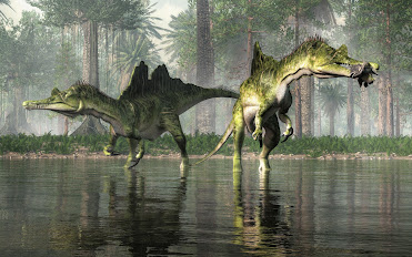
This beautiful big boy painted in yellow, green and blue is Spinosaurus aegyptiacus. 

Spinosaurus (meaning "spine lizard") is a genus of spinosaurid dinosaur that lived in what now is North Africa during the Cenomanian to upper Turonian in the Late Cretaceous— 99 to 93.5 million years ago. 

The genus was known first from Egyptian remains discovered in 1912 and described by German palaeontologist Ernst Stromer in 1915. 

The original remains were destroyed in World War II, but additional material came to light in the early 21st century.  It is unclear whether one or two species are represented in the fossils reported in the scientific literature. The best known species is S. aegyptiacus from Egypt, although a potential second species, S. maroccanus, has been recovered from Morocco. The contemporary spinosaurid genus Sigilmassasaurus has also been synonymized by some authors with S. aegyptiacus, though other researchers propose it to be a distinct taxon. 

In 2014, Ibrahim and his colleagues suggested that Spinosaurus aegyptiacus could reach over 15 metres (49 ft) in length. In 2022, however, Paul Sereno and his colleagues suggested that Spinosaurus aegyptiacus reached a maximum body length of 14 metres (46 ft) and a maximum body mass of 7.4 metric tons (8.2 short tons) by constructing an adult flesh model "with the axial column in neutral pose."

Spinosaurus is the longest known terrestrial carnivore; other large carnivores comparable to Spinosaurus include theropods such as Tyrannosaurus, Giganotosaurus and Carcharodontosaurus. The most recent study suggests that previous body size estimates are overestimated, and that S. aegyptiacus reached 14 metres (46 ft) in length and 7.4 metric tons (8.2 short tons) in body mass. 

The skull of Spinosaurus was long, low, and narrow, similar to that of a modern crocodilian, and bore straight conical teeth with no serrations. It would have had large, robust forelimbs bearing three-fingered hands, with an enlarged claw on the first digit. The distinctive neural spines of Spinosaurus, which were long extensions of the vertebrae (or backbones), grew to at least 1.65 meters (5.4 ft) long and were likely to have had skin connecting them, forming a sail-like structure, although some have suggested that the spines were covered in fat to form hump.

Monday, 29 August 2022

BEARS OF NORTHERN NORTH AMERICA

A Grizzly Bear takes a rest on a fallen log in Alaska. While stumbling upon them may cause us surprise, they have heard us 
(and smelled us) coming for miles.

If you work or play in the woods of British Columbia, both grizzly and black bear sightings are common.

Nearly half the world's population, some 25,000 Grizzly Bears, roam the Canadian wilderness — of those, 14,000 or more call British Columbia home. These highly intelligent omnivores spend their days lumbering along our coastlines, mountains and forests.

Both bear families descend from a common ancestor, Ursavus, a bear-dog the size of a raccoon who lived more than 20 million years ago. Seems an implausible lineage given the size of their very large descendants. 

An average Grizzly weighs in around 800 lbs (363 kg), but a recent find in Alaska tops the charts at 1600 lbs (726 kg). This mighty beast stood 12' 6' high at the shoulder, 14' to the top of his head and is one of the largest grizzlies ever recorded — a na̱ndzi.

Adult bears tend to live solo except during mating season. Those looking for love congregate from May to July in the hopes of finding a mate. Through adaptation to shifting seasons, the females' reproductive system delays the implantation of fertilized eggs — blastocysts —until November or December to ensure her healthy pups arrive during hibernation. If food resources were slim that year, the newly formed embryo will not catch or attach itself to her uterine wall and she'll try again next year. 

Females reach mating maturity at 4-5 years of age. They give birth to a single or up to four cubs (though usually just two) in January or February. The newborn cubs are cute little nuggets — tiny, hairless, and helpless — weighing in at 2-3 kilograms or 4-8 pounds. They feast on their mother’s nutrient-dense milk for the first two months of life. The cubs stay with their mamma for 18 months or more. Once fully grown, they can run 56 km an hour, are good at climbing trees and swimming and live 20-25 years in the wild. 

A Grizzly bear encounter inspires a humbling appreciation of just how remarkable these massive beasts are. Knowing their level of intelligence, keen memory and that they have a bite force of over 8,000,000 pascals — enough to crush a bowling ball — inspires awe and caution in equal measure. 

They have an indescribable presence. It is likely because of this that these majestic bears show up often in the superb carvings and work of First Nations artists. I have had close encounters with many bears growing up in the Pacific Northwest, meeting them up close and personal in the South Chilcotins and along our many shorelines. 

First Nation Lore and Language

In the Kwak'wala language of the Kwakiutl First Nations of the Pacific Northwest — or Kwakwaka'wakw, speakers of Kwak'wala — a Grizzly bear is known as na̱n

The ornamental carved Grizzly bear headdress was worn by the comic Dluwalakha Grizzly Bear Dancers, Once more from Heaven, in the Grizzly Bear Dance or Gaga̱lalał, is known as na̱ng̱a̱mł

The Dluwalakha dancers were given supernatural treasures or dloogwi which they passed down from generation to generation. 

In the Hamat'sa Grizzly bear dance, Nanes Bakbakwalanooksiwae, no mask was worn. Instead, the dancers painted their faces red and wore a costume of bearskin or t̓ła̱ntsa̱m and long wooden claws attached to their hands. You can imagine how impressive that sight is lit by the warm flickering flames of firelight during a Winter Dance ceremony.

Smoke of the World / Speaking of the Ancestors — Na̱wiła

Kwaguʼł Winter Dancers — Qagyuhl
Should you encounter a black bear and wish to greet them in Kwak'wala, you would call them t̕ła'yi. Kwakiutl First Nations, Smoke of the World, count Grizzly Bears as an ancestor — along with Seagull, Sun and Thunderbird. 

To tell stories of the ancestors is na̱wiła. Each of these ancestors took off their masks to become human and founded the many groups that are now bound together by language and culture as Kwakwaka’wakw. 

The four First Nations who collectively make up the Kwakiutl are the Kwakiutl (Kwágu7lh), K’umk’utis/Komkiutis, Kwixa/Kweeha (Komoyoi) and Walas Kwakiutl (Lakwilala) First Nations. 

There is likely blood of the Lawit’sis in there, too, as they inhabited the village site at Tsax̱is/T'sakis, Fort Rupert before the Kwakiutl made it a permanent home. 

Not all Kwakwaka'wakw dance the Gaga̱lalał, but their ancestors likely attended feasts where the great bear was celebrated. To speak or tell stories of the ancestors is na̱wiła — and Grizzly bear as an ancestor is na̱n helus.

Visiting British Columbia's Great Bears

If you are interested in viewing British Columbia's Great Bears, do check out Indigenous Tourism BC's wonderfully informative website and the culturally-rich wildlife experiences on offer. 

You will discover travel ideas and resources to plan your next soul-powered adventure. To learn more about British Columbia's Great Bears and the continuing legacy of First Nation stewardship, visit: 

Indigenous Tourism BC: https://www.indigenousbc.com

Great Bear Lodge has been offering tours to view the majestic animals of the Pacific Northwest. They keep both the guests and the animals' comfort and protection in mind. I highly recommend their hospitality and expertise. To see their offerings, visit: www.greatbeartours.com

Image: Group of Winter Dancers--Qagyuhl; Curtis, Edward S., 1868-1952, https://lccn.loc.gov/2003652753. 

Note: The Qagyuhl in the title of this photograph refers to the First Nation group, not the dancers themselves. I think our dear Edward was trying to spell Kwaguʼł and came as close as he was able. In Kwak'wala, the language of the Kwaguʼł or Kwakwakaʼwakw, speakers of Kwak'wala, the Head Winter Dancer is called t̕seḵa̱me' — and to call someone a really good dancer, you would use ya̱'winux̱w

Charmingly, when Edward S. Curtis was visiting Tsaxis/T'sakis, he was challenged to a wrestling competition with a Giant Pacific Octopus, Enteroctopus dofleini. George Hunt (1854-1933) had issued the challenge and laughed himself senseless when Edward got himself completely wrapped up in tentacles and was unable to move. Edward was soon untangled and went on to take many more photos of the First Nations of the Pacific Northwest. Things did not go as well for the octopus or ta̱ḵ̕wa. It was later served for dinner or dzaḵwax̱stala, as it seemed calamari was destined for that night's menu.  


Sunday, 28 August 2022

SPLIT SAIL SPINOSAURID

Back in the Cretaceous in what is now the heart of the Indochinese Peninsula, a group of mighty spinosaur with an unusual split sail were playing and hunting in the local waters. 

Picture an alligator whose legs grew especially long, add a big split sail on his back and arms that could grasp. That's kind of what these big therapod dinosaurs looked like.

The first fossil remains of Ichthyovenator were found in 2010 at Ban Kalum in the Grès Supérieurs Formation of the Savannakhet Basin in Savannakhet Province in the province of Laos. We have found other fossil remains at the site including fossil fish, iguanodontians and some compelling sauropod and ornithopod tracks.

Dinosaur remains are among the fossils that have been recovered from the formation. It is equivalent to the Khok Kruat Formation of northeastern Thailand, a fluvial formation similar in age. 

The Khok Kruat Formation is a treasure trove of fossil goodies as well. We have found the remains of fossil sharks, fish, turtles, crocodilians and pterosaurs. Phuwiangosaurus-like teeth, Siamosaurus teeth, and fragmentary postcranial remains of spinosaurids have been dug up there. We have also found Fukuiraptor-like teeth—and, being close in age, they are both Albian, it is likely just a matter of time before we find Ichthyovenator bones there as well.

Ichthyovenator had a long, shallow snout and robust forelimbs. Its diet likely mainly consisted of aquatic prey, hence its etymology. Spinosaurids are also known to have eaten small dinosaurs and pterosaurs in addition to fish. 

Ichthyovenator's conspicuous split sail might have been used for sexual display or species recognition. Fossil evidence suggests spinosaurids, especially spinosaurines, were adapted for semiaquatic lifestyles. The vertebral spines of Ichthyovenator's tail were unusually tall, suggesting—as in today's crocodilians—the tail may have aided in swimming. Ichthyovenator lived alongside sauropod and ornithopod dinosaurs, as well as bivalves, fish and turtles.

These fossilized bones were recovered from a red sandstone layer within a surface area of less than 2 square metres (22 sq ft). 

So, what did we find? So many great bits and pieces of these giant beasts as a massive jigsaw puzzle. Gathered together, they have been designated under the specimen numbers MDS BK10-01 to 15. There is a partly articulated, well-preserved skeleton. Sadly, missing are the skull and limbs. In with the bits and pieces were the third-to-last dorsal (back) vertebra, the neural spine of the last dorsal vertebra, five partial sacral (hip) vertebrae, the first two caudal (tail) vertebrae, both ilia (main hip bones), a right pubis (pubic bone), both ischia (lower and rearmost hip bones) and a posterior dorsal rib. 

The twelfth dorsal spine is bent sideways when viewed front-to-back due to taphonomic distortion. The central (vertebral bodies) of the sacrals are largely incomplete due to erosion but preserved all of their accompanying spines with their upper edges intact. 

At the time of Ichthyovenator's description, excavations at the site were still ongoing. Cast fossil spinal column laid out inside a glass display case at a museum Casts of the vertebrae at the Muséum National d'Histoire Naturelle, Paris After undergoing preparation in 2011, the skeleton was used as the basis, or holotype, for the type species Ichthyovenator laosensis, which was named and described in 2012 by palaeontologists Ronan Allain, Tiengkham Xeisanavong, Philippe Richir, and Bounsou Khentavong. 

The generic name is derived from the Old Greek word ἰχθύς (ichthys), "fish", and the Latin word venator, "hunter", in reference to its likely piscivorous or fish-eating lifestyle. The specific name refers to its provenance in Laos.

Ichthyovenator is the third named spinosaurid dinosaur from Asia after the Thai genus Siamosaurus in 1986 and the Chinese species "Sinopliosaurus" fusuiensis in 2009. The latter may represent the same animal as Siamosaurus

In 2014, Allain published a conference paper on Ichthyovenator; the abstract indicated additional remains from the original individual had been found after excavations continued in 2012. These remains include three teeth, the left pubis, and many vertebrae, including a nearly complete neck, the first dorsal vertebra, and seven more caudal vertebrae.

Some of these additional vertebrae were compared with those of other spinosaurids in a 2015 paper by German palaeontologist Serjoscha Evers and colleagues, in which they noted similarities with the vertebrae of the African spinosaurid Sigilmassasaurus

Allain and his team considered Ichthyovenator as representing the first unequivocal spinosaurid from Asia. Though prior spinosaurids had been named from the continent—including Siamosaurus from Thailand's Barremian Sao Khua Formation and "Sinopliosaurus" fusuiensis from China's Aptian Xinlong Formation—the authors noted that palaeontologists have debated the validity of these taxa because they are only confidently known from isolated teeth. 

Brazilian palaeontologists Marcos Sales and Caesar Schultz have suggested these teeth may eventually be attributed to spinosaurids similar to Ichthyovenator. In addition to tooth fossils, a spinosaurid skeleton that possibly belongs to Siamosaurus was excavated from the Thai Khok Kruat Formation in 2004 and was identified as a definite spinosaur in a 2008 conference abstract by Angela Milner and colleagues, eight years before Ichthyovenator's description.

Saturday, 27 August 2022

WARRIOR CRAB: KU'MIS

Look how epic this little guy is! 

He is a crab — and if you asked him, the fiercest warrior that ever lived. While that may not be strictly true, crabs do have the heart of a warrior and will raise their claws, sometimes only millimetres into the air, to assert dominance over their world. 

Crabs are decapod crustaceans of the Phylum Arthropoda. 

In the Kwak'wala language of the Kwakwa̱ka̱ʼwakw First Nations of the Pacific Northwest, this brave fellow is ḵ̓u'mis — both a tasty snack and familiar to the supernatural deity Tuxw'id, a female warrior spirit. Given their natural armour and clear bravery, it is a fitting role.

They inhabit all the world's oceans, sandy beaches, many of our freshwater lakes and streams. Some few prefer to live in forests.

Crabs build their shells from highly mineralized chitin — and chitin gets around. It is the main structural component of the exoskeletons of many of our crustacean and insect friends. Shrimp, crab, and lobster all use it to build their exoskeletons.

Chitin is a polysaccharide — a large molecule made of many smaller monosaccharides or simple sugars, like glucose. 

It is handy stuff, forming crystalline nanofibrils or whiskers. Chitin is actually the second most abundant polysaccharide after cellulose. It is interesting as we usually think of these molecules in the context of their sugary context but they build many other very useful things in nature — not the least of these are the hard shells or exoskeletons of our crustacean friends.

Crabs in the Fossil Record

The earliest unambiguous crab fossils date from the Early Jurassic, with the oldest being Eocarcinus from the early Pliensbachian of Britain, which likely represents a stem-group lineage, as it lacks several key morphological features that define modern crabs. 

Most Jurassic crabs are only known from dorsal — or top half of the body — carapaces, making it difficult to determine their relationships. Crabs radiated in the Late Jurassic, corresponding with an increase in reef habitats, though they would decline at the end of the Jurassic as the result of the decline of reef ecosystems. Crabs increased in diversity through the Cretaceous and represented the dominant group of decapods by the end.

We find wonderful fossil crab specimens on Vancouver Island. The first I ever collected was at Shelter Point, then again on Hornby Island, down on the Olympic Peninsula and along Vancouver Island's west coast near Nootka Sound. They are, of course, found globally and are one of the most pleasing fossils to find and aggravating to prep of all the specimens you will ever have in your collection. Bless them.


Friday, 26 August 2022

AN UNLIKELY RHINOCEROS AND GREAT DEPRESSION HISTORY

The Miocene pillow basalts from the Lake Roosevelt National Recreation Area of central Washington hold an unlikely fossil. 

What looks to be a rather unremarkable ballooning at the top of a cave is actually the mould of a small rhinoceros, preserved by sheer chance as its bloated carcass sunk to the bottom of a shallow lake just prior to a volcanic explosion.

We have known about this gem for a long while now. The fossil was discovered by hikers back in 1935 and later cast by the University of California palaeontologists in 1948. 

The Dirty Thirties & The Great Depression

These were the Dirty Thirties and those living in Washington state were experiencing the Great Depression along with the rest of the country and the world. Franklin D. Roosevelt was President of the United States, navigating the States away from laissez-faire economics. 

Charmingly, Roosevelt would have his good name honoured by this same park in April of 1946, a few years before researchers at Berkeley would rekindle interest in the site.

Both hiking and fossil collecting was a fine answer to these hard economic times and came with all the delights of discovery with no cost for natural entertainment. And so it was that two fossil enthusiast couples were out looking for petrified wood just south of Dry Falls on Blue Lake in Washington State. 

While searching the pillow basalt, the Frieles and Peabodys came across a large hole high up in a cave that had the distinctive shape of an upside-down rhinoceros.

This fossil is interesting in all sorts of ways. First, we so rarely see fossils in igneous rocks. As you might suspect, both magma and lava are very hot. Magma, or molten rock, glows a bright red/orange as it simmers at a toasty 700 °C to 1300 °C (or 1300 °F to 2400 °F) beneath the Earth's surface.

A Rhinoceros Frozen in Lava

During the late Miocene and early Pliocene, repeated basaltic lava floods engulfed about 63,000 square miles of the Pacific Northwest over a period of ten to fifteen million years. After these repeated bathings the residual lava accumulated to more than 6,000 feet.

As magma pushes up to the surface becoming lava, it cools to a nice deep black. In the case of our rhino friend, this is how this unlikely fellow became a fossil. Instead of vaporizing his remains, the lava cooled relatively quickly preserving his outline as a trace fossil and remarkably, a few of his teeth, jaw and bones. The lava was eventually buried then waters from the Spokane Floods eroded enough of the overburden to reveal the remains once more.

Diceratherium tridactylum (Marsh, 1875)
Diceratherium (Marsh, 1875) is known from over a hundred paleontological occurrences from eighty-seven collections.

While there are likely many more, we have found fossil remains of Diceratherium, an extinct genus of rhinoceros, in the Miocene of Canada in Saskatchewan, China, France, Portugal, Switzerland, and multiple sites in the United States.

He has also been found in the Oligocene of Canada in Saskatchewan, and twenty-five localities in the United States — in Arizona, Colorado, Florida, Nebraska, North Dakota, Oregon, South Dakota, Washington and Wyoming.  

Diceratherium was a scansorial insectivore with two horns and a fair bit of girth. He was a chunky fellow, weighing in at about one tonne (or 2,200 lbs). That is about the size of a baby Humpback Whale or a walrus.

Back in the Day: Washington State 15 Million-Years Ago

He roamed a much cooler Washington state some 15 million years ago. Ice dams blocked large waterways in the northern half of the state, creating reservoirs. Floodwaters scoured the eastern side of the state, leaving scablands we still see today. In what would become Idaho, volcanic eruptions pushed through the Snake River, the lava cooling instantly as it burst to the surface in a cloud of steam. 

By then, the Cascades had arrived and we had yet to see the volcanic eruptions that would entomb whole forests up near Vantage in the Takama Canyon of Washington state. 

Know Before You Go

You are welcome to go see his final resting site beside the lake but it is difficult to reach and comes with its own risks. Head to the north end of Blue Lake in Washington. Take a boat and search for openings in the cliff face. You will know you are in the right place if you see a white "R" a couple hundred feet up inside the cliff. Inside the cave, look for a cache left by those who've explored here before you. Once you find the cache, look straight up. That hole above you is the outline of the rhino.

If you don't relish the thought of basalt caving, you can visit a cast of the rhino at the Burke Museum in Seattle, Washington. They have a great museum and are pretty sporting as they have built the cast sturdy enough for folk to climb inside. 

The Burke Museum 

The Burke Museum recently underwent a rather massive facelift and has re-opened its doors to the public. You can now explore their collections in the New Burke, a 113,000 sq. ft. building at 4300 15th Ave NE, Seattle, WA 98105, United States. Or visit them virtually, at https://www.burkemuseum.org/

Photo: Robert Bruce Horsfall - https://archive.org/details/ahistorylandmam00scotgoog, Public Domain, https://commons.wikimedia.org/w/index.php?curid=12805514

Reference: Prothero, Donald R. (2005). The Evolution of North American Rhinoceroses. Cambridge University Press. p. 228. ISBN 9780521832403.

Reference: O. C. Marsh. 1875. Notice of new Tertiary mammals, IV. American Journal of Science 9(51):239-250

Lincoln, Roosevelt and Recovery from The Great Depression

Rural Tennessee has electricity for the same reason Southeast Alaska has totem parks. In order to help the nation recover from The Great Depression, President Franklin D. Roosevelt, created a number of federal agencies to put people to work. From 1938-1942 more than 200 Tlingit and Haida men carved totem poles and cleared land for the Civilian Conservation Corps in an effort to create “totem parks” the federal government hoped would draw travelers to Alaska.

This odd intersection of federal relief, Alaska Native art and marketing is the subject of Emily L. Moore’s book “Proud Raven, Panting Wolf: Carving Alaska’s New Deal Totem Parks.”

This effort to bring poles out of abandoned villages includes the Lincoln Pole being moved to Saxman Totem Park by the Civilian Conservation Corps (CCC), who established the Saxman Totem Park in 1938.  

The top carving on the Lincoln Pole bears a great likeness of Abraham Lincoln. According to the teachings of many Tlingit elders, this carving was meant to represent the first white man seen in Tlingit territory in the 18th century.  

A century later, in the 1880s, one of my ancestors from the Gaanax.ádi Raven clan of the Tongass Tlingit commissioned the pole to commemorate our ancestor's pride to have seen this first white man—which has become a Gaanax.ádi crest—using a photograph of Abraham Lincoln as the model. 

It is important not only for these various readings of the crests but also because it claims Gaanax.ádi clan territory before the first Europeans and budding Americans came to these shores—territory that Tlingit carvers who were re-carving the pole in the 1940s were trying to assert to the U.S. government as sovereign land.

Interestingly, another pole in that same park is the Dogfish Pole, carved for Chief Ebbits Andáa, Teikweidi, Valley House. The Chief Ebbits Memorial Pole—the Dogfish Kootéeyaa Pole—was raised in 1892 in Old Tongass Village in honour of a great man, Head Chief of the Tongass and my ancestor. It was then moved, re-carved and re-painted at Saxman Totem Park in 1938 as part of Roosevelt's program—and it due to be re-carved again this year. 

It tells the story of his life and the curious way he became Ebbits as he was born Neokoots. He met and traded with some early American fur traders. One of those traders was a Mister Ebbits. The two became friends and sealed that friendship with the exchanging of names.  

If you would like to read more about that pole and others, I recommend, The Wolf and the Raven, by anthropologist Viola Garfield and architect Linn Forrest (my talented cousin), published in 1961 and still in print as I ordered a copy for a friend just this year.

Wednesday, 24 August 2022

AM'DA'MA: JURASSIC SEA URCHIN

This lovely little biscuit is a Holectypus sea urchin from 120 million-year-old deposits from the Lagniro Formation of Madagascar.

The specimen you see here is in the collections of my beautiful friend Ileana. She and I were blessed to meet in China many years ago and formed an unbreakable bond that happens so few times in one's life. 

Holectypus are a genus of extinct echinoids related to modern sea urchins and sand dollars. They were abundant from the Jurassic to the Cretaceous (between 200 million and 65.5 million years ago).

This specimen is typical of Holectypus with his delicate five-star pattern adorning a slightly rounded test and flattened bottom. The specimen has been polished and was harvested both for its scientific and aesthetic value. 

I have many wonderful memories of collecting their modern cousins that live on the north end of Vancouver Island and along the beaches of Balaklava Island. In the Kwak̓wala language of the Kwakiutl or Kwakwaka'wakw, speakers of Kwak'wala, of the Pacific Northwest, sea urchins are known as a̱m'da̱'ma and it is this name that I hear in my head when I think of them.

In echinoids, the skeleton is almost always made up of tightly interlocking plates that form a rigid structure or test — in contrast with the more flexible skeletal arrangements of starfish, brittle stars, and sea cucumbers. Test shapes range from nearly globular, as in some sea urchins, to highly flattened, as in sand dollars. 

Sea Urchin Detail
Living echinoids are covered with spines, which are movable and anchored in sockets in the test. These spines may be long and prominent, as in typical sea urchins and most have lovely raised patterns on their surface. 

In sand dollars and heart urchins, however, the spines are very short and form an almost felt-like covering. The mouth of most echinoids is provided with five hard teeth arranged in a circle, forming an apparatus known as Aristotle’s lantern.

Echinoids are classified by the symmetry of the test, the number and arrangement of plate rows making up the test, and the number and arrangement of respiratory pore rows called petals. Echinoids are divided into two subgroups: regular echinoids, with nearly perfect pentameral (five-part) symmetry; and irregular echinoids with altered symmetry.

Because most echinoids have rigid tests, their ability to fossilize is greater than that of more delicate echinoderms such as starfish, and they are common fossils in many deposits. The oldest echinoids belong to an extinct regular taxon called the Echinocystitoidea. 

They first appeared in the fossil record in the Late Ordovician. Cidaroids or pencil urchins appear in the Mississippian (Early Carboniferous) and were the only echinoids to survive the mass extinction at the Permo-Triassic boundary. Echinoids did not become particularly diverse until well after the Permo-Triassic mass extinction event, evolving the diverse forms we find them in today. 

True sea urchins first appear in the Late Triassic, cassiduloids in the Jurassic, and spatangoids or heart urchins in the Cretaceous. Sand dollars, a common and diverse group today, do not make an appearance in the fossil record until the Paleocene. They remain one of my favourite echinoderms and stand tall amongst the most pleasing of the invertebrates.

Tuesday, 23 August 2022

ELASMOTHERIUM: THE STEPPE RHINOCEROS

Elasmotherium was a prehistoric cousin of the rhinoceros. These animal lived in Europe and Asia during the Pleistocene. They have a wonderfully impressive large horn that makes them easy to identify.

Elasmotherium means, "Thin Plate Beast." They are sometimes called the Steppe Rhinoceros. 

By any name they are an extinct genus of giant rhinoceros endemic to Eurasia during the Late Pliocene through the Pleistocene, documented from 2.6 million years ago, to as late as 50,000 years ago, possibly later, in the Late Pleistocene, an approximate span of slightly less than 2.6 million years. 

Three species are recognized. The best known, E. sibiricum was about the size of a mammoth and is thought to have borne a large, thick horn on its forehead which was used for defense, attracting mates, driving away competitors, sweeping snow from the grass in winter and digging for water and plant roots. 

Like all rhinoceroses, elasmotheres were herbivorous. Unlike any others, its high-crowned molars were ever-growing. Its legs were longer than those of other rhinos and were designed for galloping, giving it a horse-like gait. The Russian paleontologists of the 19th century who discovered and named the initial fossils were influenced by ancient legends of a huge unicorn roaming the steppes of Siberia. To date no evidence either contradicts or confirms the possibility that Elasmotherium survived into legendary times.