Showing posts sorted by date for query haida. Sort by relevance Show all posts

Friday 23 June 2023

VANCOUVER ISLAND'S HIDDEN GEMS: TRENT RIVER

Dan Bowen, Chair, VIPS, Trent River
The rocks that make up the Trent River on Vancouver Island were laid down south of the equator as small, tropical islands. They rode across the Pacific heading north and slightly east over the past 85 million years to where we find them today.

The Pacific Plate is an oceanic tectonic plate that lies beneath the Pacific Ocean. And it is massive. At 103 million km2 (40 million sq mi), it is the largest tectonic plate and continues to grow fed by volcanic eruptions that piggyback onto its trailing edge.

This relentless expansion pushes the Pacific Plate into the North American Plate. The pressure subducts it beneath our continent where it then melts back into the earth. Plate tectonics are slow but powerful forces. 

The island chains that rode the plates across the Pacific smashed into our coastline and slowly built the province of British Columbia. And because each of those islands had a different origin, they create pockets of interesting and diverse geology.

It is these islands that make up the Insular Belt — a physio-geological region on the northwestern North American coast. It consists of three major island groups — and many smaller islands — that stretches from southern British Columbia up into Alaska and the Yukon. These bits of islands on the move arrived from the Late Cretaceous through the Eocene — and continues to this day.

The rocks that form the Insular Superterrane are allochthonous, meaning they are not related to the rest of the North American continent. The rocks we walk over along the Trent River are distinct from those we find throughout the rest of Vancouver Island, Haida Gwaii, the rest of the province of British Columbia and completely foreign to those we find next door in Alberta.

To discover what we do find on the Trent takes only a wee stroll, a bit of digging and time to put all the pieces of the puzzle together. The first geological forays to Vancouver Island were to look for coal deposits, the profitable remains of ancient forests that could be burned to the power industry.

Jim Monger and Charlie Ross of the Geological Survey of Canada both worked to further our knowledge of the complex geology of the Comox Basin. They were at the cutting edge of west coast geology in the 1970s. It was their work that helped tease out how and where the rocks we see along the Trent today were formed and made their way north.

We know from their work that by 85 million years ago, the Insular Superterrane had made its way to what is now British Columbia. 

The lands were forested much as they are now but by extinct genera and families. The fossil remains of trees similar to oak, poplar, maple and ash can be found along the Trent and Vancouver Island. We also see the lovely remains of flowering plants such as Cupanities crenularis, figs and breadfruit.

Heading up the river, you come to a delineation zone that clearly marks the contact between the dark grey marine shales and mudstones of the Haslam Formation where they meet the sandstones of the Comox Formation. Fossilized material is less abundant in the Comox sandstones but still contains some interesting specimens. Here you begin to see fossilized wood and identifiable fossil plant material.

Further upstream, there is a small tributary, Idle Creek, where you can find more of this terrestrial material in the sandy shales. As you walk up, you see identifiable fossil plants beneath your feet and jungle-like, overgrown moss-covered, snarly trees all around you.

Walking west from the Trent River Falls at the bottom, you pass the infamous Ammonite Alley, where you can find Mesopuzosia sp. and Kitchinites sp. of the Upper Cretaceous (Santonian), Haslam Formation. Minding the slippery green algae covering some of the river rocks, you can see the first of the Polytychoceras vancouverense zone.

Continuing west, you reach the first of two fossil turtle sites on the river — amazingly, one terrestrial and one marine. If you continue, you come to the Inland Island Highway.

The Trent River has yielded some very interesting marine specimens, and significant terrestrial finds. We have found a wonderful terrestrial helochelydrid turtle, Naomichelys speciosa, and the caudal vertebrae of a Hadrosauroid dinosaur. Walking down from the Hadrosaur site you come to the site of the fossil ratfish find — one of the ocean's oddest fish.

Ratfish, Hydrolagus Collie, are chimaera found in the north-eastern Pacific Ocean today. The fossil specimen from the Trent would be considered large by modern standards as it is a bruiser in comparison to his modern counterparts. 

This robust fellow had exceptionally large eyes and sex organs that dangled enticingly between them. You mock, but there are many ratfish who would differ. While inherently sexy by ratfish standards, this fellow was not particularly tasty to their ancient marine brethren (or humans today) — so not hugely sought after as a food source or prey.

A little further again from the ratfish site we reach the contact of the two Formations. The rocks here have travelled a long way to their current location. With them, we peel away the layers of the geologic history of both the Comox Valley and the province of British Columbia.

The Trent River is not far from the Puntledge, a river whose banks have also revealed many wonderful fossil specimens. The Puntledge is also the name used by the K'ómoks First Nation to describe themselves. They have lived here since time immemorial. Along with Puntledge, they refer to themselves as Sahtloot, Sasitla and Ieeksun.

References: Note on the occurrence of the marine turtle Desmatochelys (Reptilia: Chelonioidea) from the Upper Cretaceous of Vancouver Island Elizabeth L. Nicholls Canadian Journal of Earth Sciences (1992) 29 (2): 377–380. https://doi.org/10.1139/e92-033; References: Chimaeras - The Neglected Chondrichthyans". Elasmo-research.org. Retrieved 2017-07-01.

Directions: If you're keen to explore the area, park on the side of Highway 19 about three kilometres south of Courtenay and hike up to the Trent River. Begin to look for parking about three kilometres south of the Cumberland Interchange. There is a trail that leads from the highway down beneath the bridge which will bring you to the Trent River's north side.

Saturday 17 June 2023

THE RHINO AND THE GREAT DEPRESSION

c6-vES6ZOCyry00iw-Lh-rOS2PcCINRlCF0H7yl-Z6LLWGZRgySHA4G12X_EwS-lfBbTTY79cva=s6000" style="clear: left; float: left; margin-bottom: 1em; margin-right: 1em;">
The Miocene pillow basalts from the Lake Roosevelt National Recreation Area of central Washington hold an unlikely fossil. 

What looks to be a rather unremarkable ballooning at the top of a cave is actually the mould of a small rhinoceros, preserved by sheer chance as its bloated carcass sunk to the bottom of a shallow lake just prior to a volcanic explosion.

We have known about this gem for a long while now. The fossil was discovered by hikers back in 1935 and later cast by the University of California palaeontologists in 1948. 

The Dirty Thirties & The Great Depression

These were the Dirty Thirties and those living in Washington state were experiencing the Great Depression along with the rest of the country and the world. Franklin D. Roosevelt was President of the United States, navigating the States away from laissez-faire economics. 

Charmingly, Roosevelt would have his good name honoured by this same park in April of 1946, a few years before researchers at Berkeley would rekindle interest in the site.

Both hiking and fossil collecting was a fine answer to these hard economic times and came with all the delights of discovery with no cost for natural entertainment. And so it was that two fossil enthusiast couples were out looking for petrified wood just south of Dry Falls on Blue Lake in Washington State. 

While searching the pillow basalt, the Frieles and Peabodys came across a large hole high up in a cave that had the distinctive shape of an upside-down rhinoceros.

This fossil is interesting in all sorts of ways. First, we so rarely see fossils in igneous rocks. As you might suspect, both magma and lava are very hot. Magma, or molten rock, glows a bright red/orange as it simmers at a toasty 700 °C to 1300 °C (or 1300 °F to 2400 °F) beneath the Earth's surface.

A Rhinoceros Frozen in Lava

During the late Miocene and early Pliocene, repeated basaltic lava floods engulfed about 63,000 square miles of the Pacific Northwest over a period of ten to fifteen million years. After these repeated bathings the residual lava accumulated to more than 6,000 feet.

As magma pushes up to the surface becoming lava, it cools to a nice deep black. In the case of our rhino friend, this is how this unlikely fellow became a fossil. Instead of vaporizing his remains, the lava cooled relatively quickly preserving his outline as a trace fossil and remarkably, a few of his teeth, jaw and bones. The lava was eventually buried then waters from the Spokane Floods eroded enough of the overburden to reveal the remains once more.

Diceratherium tridactylum (Marsh, 1875)
Diceratherium (Marsh, 1875) is known from over a hundred paleontological occurrences from eighty-seven collections.

While there are likely many more, we have found fossil remains of Diceratherium, an extinct genus of rhinoceros, in the Miocene of Canada in Saskatchewan, China, France, Portugal, Switzerland, and multiple sites in the United States.

He has also been found in the Oligocene of Canada in Saskatchewan, and twenty-five localities in the United States — in Arizona, Colorado, Florida, Nebraska, North Dakota, Oregon, South Dakota, Washington and Wyoming.  

Diceratherium was a scansorial insectivore with two horns and a fair bit of girth. He was a chunky fellow, weighing in at about one tonne (or 2,200 lbs). That is about the size of a baby Humpback Whale or a walrus.

Back in the Day: Washington State 15 Million-Years Ago

He roamed a much cooler Washington state some 15 million years ago. Ice dams blocked large waterways in the northern half of the state, creating reservoirs. Floodwaters scoured the eastern side of the state, leaving scablands we still see today. In what would become Idaho, volcanic eruptions pushed through the Snake River, the lava cooling instantly as it burst to the surface in a cloud of steam. 

By then, the Cascades had arrived and we had yet to see the volcanic eruptions that would entomb whole forests up near Vantage in the Takama Canyon of Washington state. 

Know Before You Go

You are welcome to go see his final resting site beside the lake but it is difficult to reach and comes with its own risks. Head to the north end of Blue Lake in Washington. Take a boat and search for openings in the cliff face. You will know you are in the right place if you see a white "R" a couple hundred feet up inside the cliff. Inside the cave, look for a cache left by those who've explored here before you. Once you find the cache, look straight up. That hole above you is the outline of the rhino.

If you don't relish the thought of basalt caving, you can visit a cast of the rhino at the Burke Museum in Seattle, Washington. They have a great museum and are pretty sporting as they have built the cast sturdy enough for folk to climb inside. 

The Burke Museum 

The Burke Museum recently underwent a rather massive facelift and has re-opened its doors to the public. You can now explore their collections in the New Burke, a 113,000 sq. ft. building at 4300 15th Ave NE, Seattle, WA 98105, United States. Or visit them virtually, at https://www.burkemuseum.org/

Photo: Robert Bruce Horsfall - https://archive.org/details/ahistorylandmam00scotgoog, Public Domain, https://commons.wikimedia.org/w/index.php?curid=12805514

Reference: Prothero, Donald R. (2005). The Evolution of North American Rhinoceroses. Cambridge University Press. p. 228. ISBN 9780521832403.

Reference: O. C. Marsh. 1875. Notice of new Tertiary mammals, IV. American Journal of Science 9(51):239-250

Lincoln, Roosevelt and Recovery from The Great Depression

Rural Tennessee has electricity for the same reason Southeast Alaska has totem parks. In order to help the nation recover from The Great Depression, President Franklin D. Roosevelt, created a number of federal agencies to put people to work. From 1938-1942 more than 200 Tlingit and Haida men carved totem poles and cleared land for the Civilian Conservation Corps in an effort to create “totem parks” the federal government hoped would draw travelers to Alaska.

This odd intersection of federal relief, Alaska Native art and marketing is the subject of Emily L. Moore’s book “Proud Raven, Panting Wolf: Carving Alaska’s New Deal Totem Parks.”

This effort to bring poles out of abandoned villages includes the Lincoln Pole being moved to Saxman Totem Park by the Civilian Conservation Corps (CCC), who established the Saxman Totem Park in 1938.  

The top carving on the Lincoln Pole bears a great likeness of Abraham Lincoln. According to the teachings of many Tlingit elders, this carving was meant to represent the first white man seen in Tlingit territory in the 18th century.  

A century later, in the 1880s, one of my ancestors from the Gaanax.ádi Raven clan of the Tongass Tlingit commissioned the pole to commemorate our ancestor's pride to have seen this first white man—which has become a Gaanax.ádi crest—using a photograph of Abraham Lincoln as the model. 

It is important not only for these various readings of the crests but also because it claims Gaanax.ádi clan territory before the first Europeans and budding Americans came to these shores—territory that Tlingit carvers who were re-carving the pole in the 1940s were trying to assert to the U.S. government as sovereign land.

Interestingly, another pole in that same park is the Dogfish Pole, carved for Chief Ebbits Andáa, Teikweidi, Valley House. The Chief Ebbits Memorial Pole—the Dogfish Kootéeyaa Pole—was raised in 1892 in Old Tongass Village in honour of a great man, Head Chief of the Tongass and my ancestor. It was then moved, re-carved and re-painted at Saxman Totem Park in 1938 as part of Roosevelt's program—and it due to be re-carved again this year. 

It tells the story of his life and the curious way he became Ebbits as he was born Neokoots. He met and traded with some early American fur traders. One of those traders was a Mister Ebbits. The two became friends and sealed that friendship with the exchanging of names.  

If you would like to read more about that pole and others, I recommend, The Wolf and the Raven, by anthropologist Viola Garfield and architect Linn Forrest (my talented cousin), published in 1961 and still in print as I ordered a copy for a friend just this year.

Thursday 8 June 2023

VANCOUVER ISLAND'S FABULOUS FOSSILS: TRENT RIVER PALAEONTOLOGY

Dan Bowen, Chair, VIPS, Trent River
The rocks that make up the Trent River on Vancouver Island are on the move. They were laid down near of the equator as small, tropical islands. They rode across the Pacific heading north and slightly east over the past 85 million years to where we find them today.

The Pacific Plate is an oceanic tectonic plate that lies beneath the Pacific Ocean. And it is massive. At 103 million km2 (40 million sq mi), it is the largest tectonic plate and continues to grow fed by volcanic eruptions that piggyback onto its trailing edge.

This relentless expansion pushes the Pacific Plate into the North American Plate. The pressure subducts it beneath our continent where it then melts back into the earth. Plate tectonics are slow but powerful forces. 

The island chains that rode the plates across the Pacific smashed into our coastline and slowly built the province of British Columbia. And because each of those islands had a different origin, they create pockets of interesting and diverse geology.

It is these islands that make up the Insular Belt — a physio-geological region on the northwestern North American coast. It consists of three major island groups — and many smaller islands — that stretches from southern British Columbia up into Alaska and the Yukon. These bits of islands on the move arrived from the Late Cretaceous through the Eocene — and continues to this day.

The rocks that form the Insular Superterrane are allochthonous, meaning they are not related to the rest of the North American continent. The rocks we walk over along the Trent River are distinct from those we find throughout the rest of Vancouver Island, Haida Gwaii, the rest of the province of British Columbia and completely foreign to those we find next door in Alberta.

To discover what we do find on the Trent takes only a wee stroll, a bit of digging and time to put all the pieces of the puzzle together. The first geological forays to Vancouver Island were to look for coal deposits, the profitable remains of ancient forests that could be burned to the power industry.

Jim Monger and Charlie Ross of the Geological Survey of Canada both worked to further our knowledge of the complex geology of the Comox Basin. They were at the cutting edge of west coast geology in the 1970s. It was their work that helped tease out how and where the rocks we see along the Trent today were formed and made their way north.

We know from their work that by 85 million years ago, the Insular Superterrane had made its way to what is now British Columbia. 

The lands were forested much as they are now but by extinct genera and families. The fossil remains of trees similar to oak, poplar, maple and ash can be found along the Trent and Vancouver Island. We also see the lovely remains of flowering plants such as Cupanities crenularis, figs and breadfruit.

Heading up the river, you come to a delineation zone that clearly marks the contact between the dark grey marine shales and mudstones of the Haslam Formation where they meet the sandstones of the Comox Formation. Fossilized material is less abundant in the Comox sandstones but still contains some interesting specimens. Here you begin to see fossilized wood and identifiable fossil plant material.

Further upstream, there is a small tributary, Idle Creek, where you can find more of this terrestrial material in the sandy shales. As you walk up, you see identifiable fossil plants beneath your feet and jungle-like, overgrown moss-covered, snarly trees all around you.

Walking west from the Trent River Falls at the bottom, you pass the infamous Ammonite Alley, where you can find Mesopuzosia sp. and Kitchinites sp. of the Upper Cretaceous (Santonian), Haslam Formation. Minding the slippery green algae covering some of the river rocks, you can see the first of the Polytychoceras vancouverense zone.

Continuing west, you reach the first of two fossil turtle sites on the river — amazingly, one terrestrial and one marine. If you continue, you come to the Inland Island Highway.

The Trent River has yielded some very interesting marine specimens, and significant terrestrial finds. We have found a wonderful terrestrial helochelydrid turtle, Naomichelys speciosa, and the caudal vertebrae of a Hadrosauroid dinosaur. Walking down from the Hadrosaur site you come to the site of the fossil ratfish find — one of the ocean's oddest fish.

Ratfish, Hydrolagus Collie, are chimaera found in the north-eastern Pacific Ocean today. The fossil specimen from the Trent would be considered large by modern standards as it is a bruiser in comparison to his modern counterparts. 

This robust fellow had exceptionally large eyes and sex organs that dangled enticingly between them. You mock, but there are many ratfish who would differ. While inherently sexy by ratfish standards, this fellow was not particularly tasty to their ancient marine brethren (or humans today) — so not hugely sought after as a food source or prey.

A little further again from the ratfish site we reach the contact of the two Formations. The rocks here have travelled a long way to their current location. With them, we peel away the layers of the geologic history of both the Comox Valley and the province of British Columbia.

The Trent River is not far from the Puntledge, a river whose banks have also revealed many wonderful fossil specimens. The Puntledge is also the name used by the K'ómoks First Nation to describe themselves. They have lived here since time immemorial. Along with Puntledge, they refer to themselves as Sahtloot, Sasitla and Ieeksun.

References: Note on the occurrence of the marine turtle Desmatochelys (Reptilia: Chelonioidea) from the Upper Cretaceous of Vancouver Island Elizabeth L. Nicholls Canadian Journal of Earth Sciences (1992) 29 (2): 377–380. https://doi.org/10.1139/e92-033; References: Chimaeras - The Neglected Chondrichthyans". Elasmo-research.org. Retrieved 2017-07-01.

Directions: If you're keen to explore the area, park on the side of Highway 19 about three kilometres south of Courtenay and hike up to the Trent River. Begin to look for parking about three kilometres south of the Cumberland Interchange. There is a trail that leads from the highway down beneath the bridge which will bring you to the Trent River's north side.

Tuesday 16 May 2023

SAYWARD FOSSILS OF VANCOUVER ISLAND

Coroniceras sp. from Sayward, British Columbia
This yummy Lower Jurassic ammonite with the creamy dark chocolate colouring is from an all but inaccessible outcrop of the Upper Sinemurian, Bonanza Group,  Harbledownense Zone, Memekay River area, near Sayward, Vancouver Island, British Columbia, Canada. 

This area is home to the We Wai Kai and Wei Wai Kum First Nations and lands of the K'omoks whose culture thrives and reflects the natural rugged beauty of the central island region.

I passed through Sayward earlier this month on the way to northern Vancouver Island. 

It is rugged, remote and beautiful. Think trees and valleys for as far as the eye can see. Some of those hillsides on the horizon contain wonderful fossils, including this Coroniceras sp. with the truly marvellous keel.

By the time these ammonites were being buried in sediment, Wrangellia, the predominately volcanic terrane that now forms Vancouver Island and Haida Gwaii, had made its way to the northern mid-latitudes.

Within the basal part of the sequence, sedimentary beds are found interbedded with lapilli and crystal tuffs. Here you'll see maroon tuffaceous sandstone, orange-grey sandstone, granule sandstone and conglomerate. Within them we find ammonites nestled in with gastropods and pelecypods. 

While the fossiliferous outcrop is quite small, the Bonanza group is much larger, estimated to be at least 1000 metres thick. The site is quite small and in an active logging area, so the window to collect was limited. The drive up the mountain was thrilling as there had just been heavy rains and the road was washed out and narrowed until it was barely the width of our wheelbase and very, very steep. Closer to the top it narrowed to be just shy of the width of the vehicle — thrilling, to say the least. 

So scary that my passengers all got out as there was a high probability of going head-first over the edge. I was navigating by some handwritten field notes and a wee map on a paper napkin that should have read, "park at the bottom and hike up." 

Did we park at the bottom and hike up? No, we did not. 

The torrential rains of the Pacific Northwest had been working their magic on the hillside and slowly washing out the road until it slowly became more of a trail.

At the base of the hillside all looked well. Giddy for the fossils to come, we ventured off with a truck full of enthusiasm. Within 15 minutes of steep elevation gain, we had a wonderful view of the valley below. We were halfway up the mountain before I realized the error of my ways. The road twisted and turned then slowly narrowed to the width of my tires. Too narrow to turn around, so the only way was up. 

Graham Beard from Qualicum Beach was the fellow who showed me the site and drew the wee map for me. I cannot recall everyone on the trip, but Perry Poon was there — he shot a video of the drive up that he described as thrilling. I have never seen it but would like to one day — and so was Patricia Coutts with her lovely Doberman. 

She and I had just done a trip up to Goldbridge where the cliff we were on had turned into a landslide into a ravine so she was feeling understandably cautious about the power of Mother Nature. 

Picture the angle, the hood of my jeep riding high and hiding what remained of the road beneath and a lovely stick shift that made you roll backwards a wee bit with every move to put it into gear. So, without being able to see the very narrow path beneath, I had to just keep going. 

Both Perry and Patricia helped with filling in the potholes so my tires would have something to grip. 

I bent the frame on the jeep heading up and had some explaining to do when I returned it to the car rental place. 

As I recall, I wasn't in my ordinary vehicle but a rental because my car had been stolen the weekend before when I was away with John Fam and Dan Bowen collecting at Jurassic Point, an epic fossil site accessible only by boat on our wild west coast.

Fortuitous timing really, as they stole my car but I had unloaded my precious fossil collecting gear out of the trunk just days before.  

In the end, we found what we were looking for. Memekay yields a mix of ammonites, gastropods and bivalves. 

Many of them are poorly preserved. It was a hell of a ride but well worth the effort as we found some great fossils and with them more information on the palaeontology and geology of Vancouver Island. Just look at the keel on this beauty.

I would share the site information but it is now covered over with debris and inaccessible. One day, this whole region will be developed and the site will be opened up again. Until then, we'll have to enjoy what has been unearthed.

Saturday 13 May 2023

DOUVILLEICERAS MAMMILLATUM

Some lovely examples of Douvilleiceras mammillatum (Schlotheim, 1813), ammonites from the Lower Cretaceous (Middle-Lower Albian) Douvilliceras inequinodum zone of Ambarimaninga, Mahajanga Province, Madagascar.

The genus Douvilleiceras range from Middle to Late Cretaceous and can be found in Asia, Africa, Europe and North and South America. 

We have beautiful examples in the early to mid-Albian from the archipelago of Haida Gwaii in British Columbia. Joseph F. Whiteaves was the first to recognize the genus from Haida Gwaii when he was looking over the early collections of James Richardson and George Dawson. The beauties you see here measure 6cm to 10cm.

Thursday 30 March 2023

HAIDA GWAII: HAADALA GWAII-AI

A wreck with tales to tell at Naikoon, Haida Gwaii. The islands have gone by many names. To the people who call the islands home, Haida Gwaii means “island of the people,” it is a shortened version of an earlier name, Haadala Gwaii-ai, or “taken out of concealment.” 

Back at the time of Nangkilslas, it was called Didakwaa Gwaii, or “shoreward country.” 

By any name, the islands are a place of rugged beauty and spirit and enjoy a special place in both the natural and supernatural world. The enormous difference between high and low tide in Haida Gwaii – up to twenty three vertical feet – means that twice a day, vast swathes of shellfish are unveiled, free for the taking. 

An ancient Haida saying is still often heard today, “When the tide is out, the table is set.” Archaeological evidence shows that by about five thousand years ago, gathering shellfish replaced hunting and fishing as their primary food source. The shellfish meat was skewered on sticks, smoked and stored for use in winter or for travel.

Steeped in mist and mythology, the islands of Haida Gwaii abound in local lore that surrounds their beginnings. Today, the Hecate Strait is a tempestuous 40-mile wide channel that separates the mist-shrouded archipelago of Haida Gwaii from the BC mainland. Haida oral tradition tells of a time when the strait was mostly dry, dotted here and there with lakes. During the last ice age, glaciers locked up so much water that the sea level was hundreds of feet lower than it is today. Soil samples from the sea floor contain wood, pollen, and other terrestrial plant materials that tell of a tundra-like environment.

The islands of Haida Gwaii are at the western edge of the continental shelf and form part of Wrangellia, an exotic terrane of former island arcs, which also includes Vancouver Island, parts of western mainland British Columbia and southern Alaska. 

Brewericeras hulenense (Anderson, 1938)
While we’ll see that there are two competing schools of thought on Wrangellia’s more recent history, both sides agree that many of the rocks, and the fossils they contain, were laid down somewhere near the equator. 

They had a long, arduous journey, first being pushed by advancing plates, then being uplifted, intruded, folded, and finally thrust up again. It’s reminiscent of how pastry is balled up, kneaded over and over, finally rolled out, then the process is repeated again.

This violent history applies to most of the rock that makes up the Insular Belt, the outermost edge of the Cordillera. Once in their present location, the rocks that make up the mountains and valleys of this island group were glaciated and eroded to their present form. Despite this tumultuous past, the islands have arguably the best-preserved and most fossil-rich rocks in the Canadian Cordillera, dating from very recent to more than 200 million years old. 

The fossils found in the Triassic rock of Wrangellia are equatorial or low latitude life forms quite different from those found today on the Continent at the latitude of Haida Gwaii. This suggests those rocks were in the equatorial region during the Late Triassic, just over 200 million years ago. 

The Lower Jurassic ammonite faunas found at Haida Gwaii are very similar to those found in the Eastern Pacific around South America and in the Mediterranean. The strata exposed at Maple Island, Haida Gwaii are stratigraphically higher than the majority of Albian localities in Skidegate Inlet. The macrofossil fauna belonged to the Upper part of the Sandstone Member of the Haida formation.

The western end of the island contains numerous well-preserved inoceramids such as Birostrina concentrica and a few rare ammonites of Desmoceras bearskinese. The eastern shores are home to unusual ammonite fauna in the finer grained sandstones. Here we find the fossils as extremely hard concretions while others were loose in the shale. Species include Anagaudryceras sacya and Tetragonites subtimotheanus. A large whorl section of the rare Ammonoceratites crenucostatus has also been found here. The ammonites, Desmoceras; Brewericeras hulenense; Cleoniceras perezianum, Douvelliceras spiniferum are all found in Lower Cretaceous, Middle Albian, Haida Formation deposits.

Sunday 29 January 2023

VANCOUVER'S HISTORIC STANLEY PARK

Totem, Welcome & Mortuary Poles at Stanley Park
If you visit Brockton Point in Stanley Park, there are many carved red cedar First Nation poles for you to admire.  

What you are viewing are replicas of First Nation welcome and totem poles that once stood in the park but have been returned to their homes within the province's diverse First Nation communities — or held within museum collections. 

Some of the original totems came from Alert Bay on Cormorant Island, near the Port McNeill on the north coast of Vancouver Island. 

Others came from communities in Haida Gwaii — and still more from the Wuikinuxv First Nations at Rivers Inlet on British Columbia's central west coast — home of the Great Bear Rainforest with her Spirit Bears.

The exception is the most recent addition carved by Robert Yelton in 2009. Robert is a First Nation carver from the Squamish Nation and his original welcome pole graces Brockton Point, the original settlement site of a group of Squamish-Portuguese settlers.  

If you look at the photo above, the lovely chocolate, red and turquoise pole on the right is a replica of the mortuary pole raised to honour the Raven Chief of Skedans or Gida'nsta, the Haida phrase for from his daughter, the title of respect used when addressing a person of high rank. Early fur traders often took the name of the local Chief and used it synonymously as the place names for the sites they visited — hence Skedans from Gida'nsta.

Chief Skedans Mortuary Pole
Chief Skedans, or Qa'gials qe'gawa-i, to his children, lived in Ḵ’uuna Llnagaay, or village at the edge, in Xaayda Kil — a village on the exposed coast of Louise Island — now a Haida Heritage Site.  

There are some paintings you may have seen by Emily Carr of her visits to the site in 1912, She used the phonetic Q'una from Q:o'na to describe both the place name and title of her work. 

Carr's paintings of the totems have always looked to me to be a mash-up — imagine if painter Tamara de Lempicka and photographer Edward Curtis had a baby — not pretty, but interesting.

Some called this area, Huadju-lanas or Xu'adji la'nas, which means Grizzly-Bear-Town, in reference to resident grizzly bear population and their adornment of many totems and artwork by the local artists.

Upon Chief Skedan's death, the mortuary pole was carved both to honour him and provide his final resting place. Dates are a bit fuzzy, but local accounts have this as sometime between 1870-1878 — and at a cost of 290 blankets or roughly $600 in today's currency. 

The great artistry of the pole was much admired by those in the community and those organizing the celebrations for the 1936 Vancouver Golden Jubilee — witnessed by  350,000 newly arrived residents.

Negotiations were pursued and the pole made its way down from Haida Gwaii to Stanley Park in time for the celebrations. The original totem graced Stanley Park for a little over twenty years before eventually making its way back to Haida Gwaii. It was returned to the community with bits of plaster and shoddy paint marring the original. These bits were scraped off and the pole welcomed back with due ceremony. 

In 1964, respected and renowned Northwest Coast master carver, Bill Reid, from the Kaadaas gaah Kiiguwaay, Raven/Wolf Clan of T'anuu, Haida Gwaii and Scottish-German descent, was asked to carve this colourful replica. 

Mountain Goat Detail, Skedans Mortuary Pole
Reid carved the totem onsite in Stanley Park with the help of German carver Werner True. Interestingly, though I looked at length for information on Werner True, all I can find is that he aided Bill Reid on the carving for a payment of $1000.

Don Yeomans, Haida master carver, meticulously recarved the moon crest in 1998. If you have admired the totem pole in the Vancouver Airport, you will have seen some of Yeoman's incredible work. 

The crest is Moon with the face, wings, legs and claws of a mighty and proud Thunderbird with a fairly smallish hooked beak in a split design. We have Moon to thank for the tides and for illuminating our darkest nights. As a crest, Moon is associated with transformation and acts as both guardian and protector.

The original pole had a mortuary box that held the Chief's remains. The crest sits atop a very charming mountain goat. I have included a nice close-up here of the replica for you to enjoy. 

Mountain Goats live in the high peaks of British Columbia and being so close to the sky, they have the supernatural ability to cross over to the sky world. They are also credited as being spirit guardians and guides to First Nation shamans.

I love his horns and tucked-in cloven hooves. There is another pole being carved on Vancouver Island that I hope to see during its creation that also depicts a Mountain Goat. With permission and in time, I hope to share some of those photos with you. 

Mountain Goat is sitting atop Grizzly Bear or Huaji or Xhuwaji’ with little human figures placed in his ears to represent the Chief's daughter and son-in-law, who raised the pole and held a potlatch in his honour. 

Beneath the great bear is Seal or Killer Whale in his grasp. The inscription in the park says it is a Killer Whale but I am not sure about that interpretation — both the look and lore make Seal more likely. Perhaps if Killer Whale were within Thunderbird's grasp — maybe

Though it is always a pleasure to see Killer Whale carved in red cedar, as the first whales came into being when they were carved in wood by a human — or by Raven — then magically infused with the gift of life.

Siwash Rock on the northern end of Third Beach, Stanley Park
The ground these totems sit upon is composed of plutonic, volcanic and sedimentary layers of rock and exhibits the profound influences of glaciation and glacial retreat from the last ice age. 

Glacial deposits sit atop a mix of clay, sand, cobbles and larger boulders of glacial till. 

There are a few areas of exposed volcanics within the park that speak to the scraping of the glaciers as they retreated about 12,500 years ago. 

The iconic moss and lichen-coated Siwash Rock on the northern end of Third Beach is one of the more picturesque of these. It is a basaltic and andesitic volcanic rock — a blend of black phenocrysts of augite cemented together with plagioclase, hornblende and volcanic glass that holds a special place in the oral history of the First Nations of this area. The Squamish First Nation, or Sḵwx̱wú7mesh sníchim, hold the word Slhx̱i7lsh for this rock. 

They tell a story of a man fishing by the shore who was transformed by the spirit-being X̱áays into this iconic rock near the northern end of Third Beach of Stanley Park. At the time, a permanent First Nation settlement was just a short walk away. The man had his fishing gear with him when he was transformed as he had been fishing near the shore. The hole in the rock is not from the erosion of the tides but the cubby hole where Slhx̱i7lsh, now a rocky sentinel, kept his fishing tackle. And as you know, fishing tackle is valuable. One does not simply throw it away simply because you have been turned to stone.

Images not shown: 

Do check out the work of Emily Carr and her paintings of Q:o'na from the 1940s. I'll share a link here but do not have permission to post her works. http://www.emilycarr.org/totems/exhibit/haida/ssintro.htm

Sunday 22 January 2023

AN UNLIKELY RHINOCEROS AND THE GREAT DEPRESSION

The Miocene pillow basalts from the Lake Roosevelt National Recreation Area of central Washington hold an unlikely fossil. 

What looks to be a rather unremarkable ballooning at the top of a cave is actually the mould of a small rhinoceros, preserved by sheer chance as its bloated carcass sunk to the bottom of a shallow lake just prior to a volcanic explosion.

We have known about this gem for a long while now. The fossil was discovered by hikers back in 1935 and later cast by the University of California palaeontologists in 1948. 

The Dirty Thirties & The Great Depression

These were the Dirty Thirties and those living in Washington state were experiencing the Great Depression along with the rest of the country and the world. Franklin D. Roosevelt was President of the United States, navigating the States away from laissez-faire economics. 

Charmingly, Roosevelt would have his good name honoured by this same park in April of 1946, a few years before researchers at Berkeley would rekindle interest in the site.

Both hiking and fossil collecting was a fine answer to these hard economic times and came with all the delights of discovery with no cost for natural entertainment. And so it was that two fossil enthusiast couples were out looking for petrified wood just south of Dry Falls on Blue Lake in Washington State. 

While searching the pillow basalt, the Frieles and Peabodys came across a large hole high up in a cave that had the distinctive shape of an upside-down rhinoceros.

This fossil is interesting in all sorts of ways. First, we so rarely see fossils in igneous rocks. As you might suspect, both magma and lava are very hot. Magma, or molten rock, glows a bright red/orange as it simmers at a toasty 700 °C to 1300 °C (or 1300 °F to 2400 °F) beneath the Earth's surface.

A Rhinoceros Frozen in Lava

During the late Miocene and early Pliocene, repeated basaltic lava floods engulfed about 63,000 square miles of the Pacific Northwest over a period of ten to fifteen million years. After these repeated bathings the residual lava accumulated to more than 6,000 feet.

As magma pushes up to the surface becoming lava, it cools to a nice deep black. In the case of our rhino friend, this is how this unlikely fellow became a fossil. Instead of vaporizing his remains, the lava cooled relatively quickly preserving his outline as a trace fossil and remarkably, a few of his teeth, jaw and bones. The lava was eventually buried then waters from the Spokane Floods eroded enough of the overburden to reveal the remains once more.

Diceratherium tridactylum (Marsh, 1875)
Diceratherium (Marsh, 1875) is known from over a hundred paleontological occurrences from eighty-seven collections.

While there are likely many more, we have found fossil remains of Diceratherium, an extinct genus of rhinoceros, in the Miocene of Canada in Saskatchewan, China, France, Portugal, Switzerland, and multiple sites in the United States.

He has also been found in the Oligocene of Canada in Saskatchewan, and twenty-five localities in the United States — in Arizona, Colorado, Florida, Nebraska, North Dakota, Oregon, South Dakota, Washington and Wyoming.  

Diceratherium was a scansorial insectivore with two horns and a fair bit of girth. He was a chunky fellow, weighing in at about one tonne (or 2,200 lbs). That is about the size of a baby Humpback Whale or a walrus.

Back in the Day: Washington State 15 Million-Years Ago

He roamed a much cooler Washington state some 15 million years ago. Ice dams blocked large waterways in the northern half of the state, creating reservoirs. Floodwaters scoured the eastern side of the state, leaving scablands we still see today. In what would become Idaho, volcanic eruptions pushed through the Snake River, the lava cooling instantly as it burst to the surface in a cloud of steam. 

By then, the Cascades had arrived and we had yet to see the volcanic eruptions that would entomb whole forests up near Vantage in the Takama Canyon of Washington state. 

Know Before You Go

You are welcome to go see his final resting site beside the lake but it is difficult to reach and comes with its own risks. Head to the north end of Blue Lake in Washington. Take a boat and search for openings in the cliff face. You will know you are in the right place if you see a white "R" a couple hundred feet up inside the cliff. Inside the cave, look for a cache left by those who've explored here before you. Once you find the cache, look straight up. That hole above you is the outline of the rhino.

If you don't relish the thought of basalt caving, you can visit a cast of the rhino at the Burke Museum in Seattle, Washington. They have a great museum and are pretty sporting as they have built the cast sturdy enough for folk to climb inside. 

The Burke Museum 

The Burke Museum recently underwent a rather massive facelift and has re-opened its doors to the public. You can now explore their collections in the New Burke, a 113,000 sq. ft. building at 4300 15th Ave NE, Seattle, WA 98105, United States. Or visit them virtually, at https://www.burkemuseum.org/

Photo: Robert Bruce Horsfall - https://archive.org/details/ahistorylandmam00scotgoog, Public Domain, https://commons.wikimedia.org/w/index.php?curid=12805514

Reference: Prothero, Donald R. (2005). The Evolution of North American Rhinoceroses. Cambridge University Press. p. 228. ISBN 9780521832403.

Reference: O. C. Marsh. 1875. Notice of new Tertiary mammals, IV. American Journal of Science 9(51):239-250

Lincoln, Roosevelt and Recovery from The Great Depression

Rural Tennessee has electricity for the same reason Southeast Alaska has totem parks. In order to help the nation recover from The Great Depression, President Franklin D. Roosevelt, created a number of federal agencies to put people to work. From 1938-1942 more than 200 Tlingit and Haida men carved totem poles and cleared land for the Civilian Conservation Corps in an effort to create “totem parks” the federal government hoped would draw travelers to Alaska.

This odd intersection of federal relief, Alaska Native art and marketing is the subject of Emily L. Moore’s book “Proud Raven, Panting Wolf: Carving Alaska’s New Deal Totem Parks.”

This effort to bring poles out of abandoned villages includes the Lincoln Pole being moved to Saxman Totem Park by the Civilian Conservation Corps (CCC), who established the Saxman Totem Park in 1938.  

The top carving on the Lincoln Pole bears a great likeness of Abraham Lincoln. According to the teachings of many Tlingit elders, this carving was meant to represent the first white man seen in Tlingit territory in the 18th century.  

A century later, in the 1880s, one of my ancestors from the Gaanax.ádi Raven clan of the Tongass Tlingit commissioned the pole to commemorate our ancestor's pride to have seen this first white man—which has become a Gaanax.ádi crest—using a photograph of Abraham Lincoln as the model. 

It is important not only for these various readings of the crests but also because it claims Gaanax.ádi clan territory before the first Europeans and budding Americans came to these shores—territory that Tlingit carvers who were re-carving the pole in the 1940s were trying to assert to the U.S. government as sovereign land.

Interestingly, another pole in that same park is the Dogfish Pole, carved for Chief Ebbits Andáa, Teikweidi, Valley House. The Chief Ebbits Memorial Pole—the Dogfish Kootéeyaa Pole—was raised in 1892 in Old Tongass Village in honour of a great man, Head Chief of the Tongass and my ancestor. It was then moved, re-carved and re-painted at Saxman Totem Park in 1938 as part of Roosevelt's program—and it due to be re-carved again this year. 

It tells the story of his life and the curious way he became Ebbits as he was born Neokoots. He met and traded with some early American fur traders. One of those traders was a Mister Ebbits. The two became friends and sealed that friendship with the exchanging of names.  

If you would like to read more about that pole and others, I recommend, The Wolf and the Raven, by anthropologist Viola Garfield and architect Linn Forrest (my talented cousin), published in 1961 and still in print as I ordered a copy for a friend just this year.

Thursday 12 January 2023

TRACKING THROUGH THE TRIASSIC

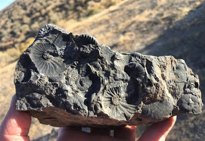
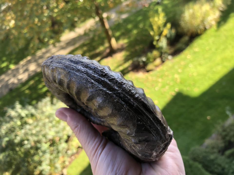
Grambergia sp. Middle Triassic Ammonoid of  BC, Canada
In the early 1980s, Tim Tozer, Geological Survey of Canada was looking at the spread of marine invertebrate fauna in the Triassic of North America. 

In the western terranes of the Cordillera, marine faunas from southern Alaska and Yukon to Mexico are known from the parts that are obviously allochthonous with regard to the North American plates.

Lower and upper Triassic faunas of these areas, as well as some that are today up to 63 ° North, have the characteristics of the lower palaeo latitudes. 

In the western Cordillera, these faunas of the lower paleo latitudes can be found up to 3,000 km north of their counterparts on the American plate. This indicates a tectonic shift of significant magnitude. There are marine triads on the North American plate over 46 latitudes from California to Ellesmere Island. 

For some periods, two to three different faunal provinces can be distinguished. The differences in faunal species are linked, not surprisingly, to their palaeolatitude. They are called LPL, MPL, HPL (lower, middle, higher palaeolatitude).

Nevada provides the diagnostic features of the lower (LPL); northeastern British Columbia that of the middle (MPL) and Sverdrup Basin, the large igneous province on Axel Heiberg Island and Ellesmere Island, Nunavut, Canada near the rifted margin of the Arctic Ocean, that of the higher palaeolatitude (HPL).

A distinction between the provinces of the middle and the higher palaeo-situations can not be made for the lower Triassic and lower Middle Triassic (anise). However, all three provinces can be seen in the deposits of Ladin, Kam and Nor.

In the early 2000s, as part of a series of joint UBC, VIPS and VanPS fossil field trips (and then Chair of the VanPS), I explored much of the lower faunal outcrops of northeastern British Columbia. It was my first time seeing many of British Columbia's Triassic outcrops. Years later, and fueled by seeing paper after paper correlating the faunal assemblages of BC to those of Nevada, I had the very great pleasure of walking through the Nevada strata with John Fam (VanPS, Vice-Chair), Dan Bowen (VIPS, Chair) and Betty Franklin (VIPS, Goddess of Everything and BCPA, Treasurer) — and witnessing first-hand the correlation between the Nevada fauna and those from the Triassic of British Columbia, Canada.

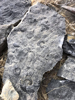
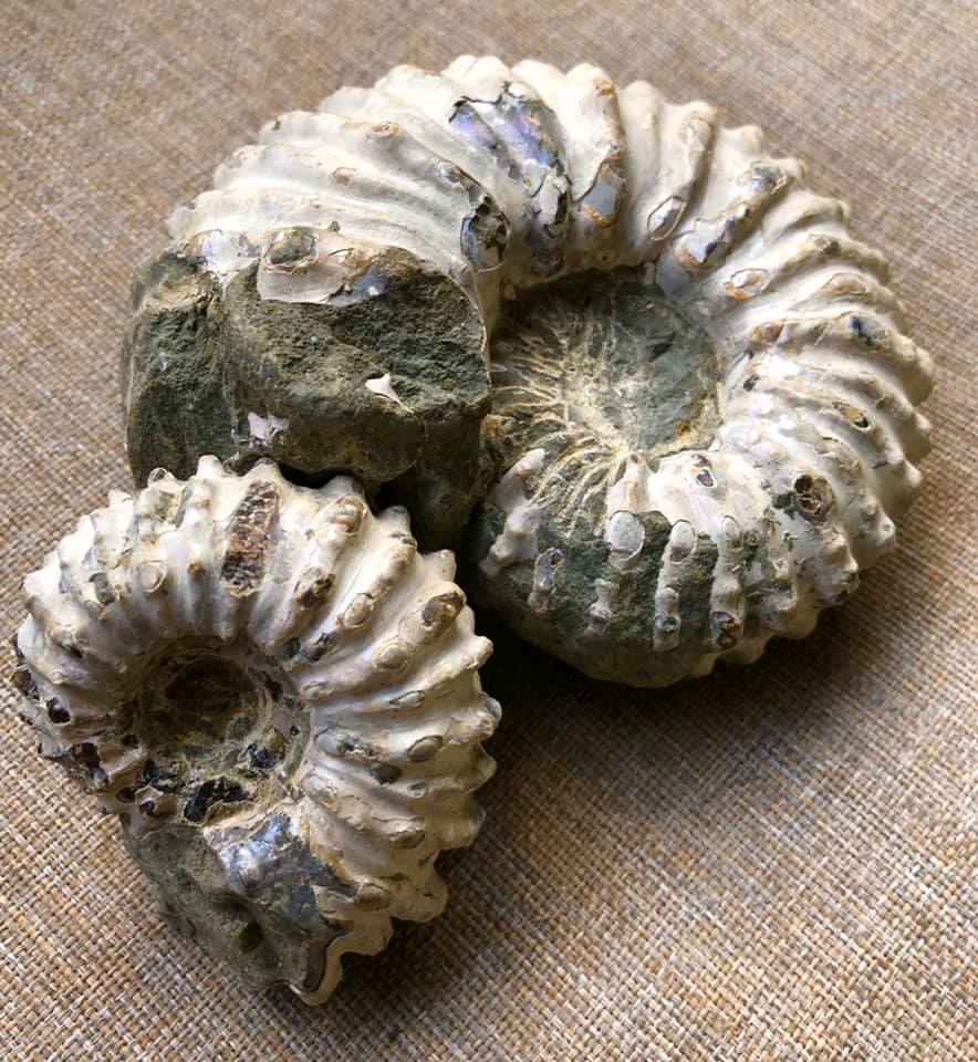
Triassic ammonoids, West Humboldt Mountains, Nevada, USA
The Nevada faunal assemblages are a lovely match. The quality of preservation at localities like Fossil Hill in the Humboldt Mountains of Nevada, perhaps the most famous and important locality for the Middle Triassic (Anisian/Ladinian) of North America, is truly outstanding.

Aside from sheer beauty and spectacular preservation, the ammonoids and belemnites were tucked in cozily with very well preserved ichthyosaur remains.

Tozer's interest in our marine invert friends was their distribution. How and when did certain species migrate, cluster, evolve — and for those that were prolific, how could their occurrence — and therefore significance — aide in an assessment of plate and terrane movements that would help us to determine paleolatitudinal significance. 

I share a similar interest but not exclusive to our cephalopod fauna. The faunal collection of all of the invertebrates holds appeal.

Middle Triassic (Anisian/Ladinian) Fauna
This broader group held an interest for J.P. Smith who published on the marine fauna in the early 1900s based on his collecting in scree and outcrops of the West Humboldt Mountains, Nevada. He published his first monograph on North American Middle Triassic marine invertebrate fauna in 1914.

N. J. Siberling from the US Geological Survey published on these same Nevada outcrops in 1962. His work included nearly a dozen successive ammonite faunas, many of which were variants on previously described species. Both their works would inform what would become a lifelong piecing together of the Triassic puzzle for Tozer.

If one looks at the fauna and the type of sediment, the paleogeography of the Triassic can be interpreted as follows: a tectonically calm west coast of the North American plate that bordered on an open sea; in the area far from the coast, a series of volcanic archipelagos delivered sediment to the adjacent basins. 

Some were lined or temporarily covered with coral wadding and carbonate banks. Deeper pools were in between. The islands were probably within 30 degrees of the triadic equator. They moved away from the coast up to about 5000 km from the forerunner of the East Pacific Ridge. The geographical situation west of the back was probably similar.

Jurassic and later generations of the crust from near the back have brought some of the islands to the North American plate; some likely to South America; others have drifted west, to Asia. There are indications that New Guinea, New Caledonia and New Zealand were at a northern latitude of 30 ° or more during the Triassic period.

The terranes that now form the western Cordillera were probably welded together and reached the North American plate before the end of the Jurassic period.

Marine Triassic occurs on the North American Plate over a latitudinal spread of 46 degrees, from California to Ellesmere Island. At some intervals of time faunas on the Plate permit the discrimination of two or three provinces with distinctively different coeval faunas. 

The faunal differences are evidently related to paleolatitude and the provinces are designated LPL, MPL, HPL (low, mid, high paleolatitude). Nevada provides the diagnostic characters of the LPL province; northeastern British Columbia the MPL; the Sverdrup Basin the HPL. In the Lower Triassic and early Middle Triassic (Anisian), the distinction between the MPL and HPL provinces cannot be made. All three provinces are recognized in the Ladinian, Carnian and Norian deposits.

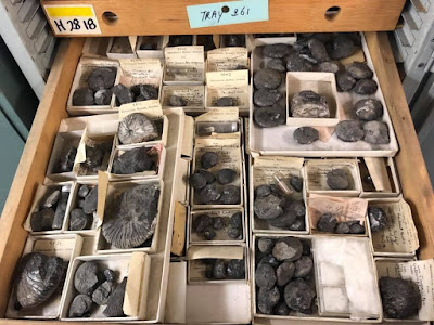
Juvavites sp. Geological Survey of Canada. Photo: John Fam
In the western tracts of the Cordillera, the part formed of suspect terranes, apparently allochthonous with respect to the North American Plate, marine faunas are known all the way from southern Alaska and Yukon to Mexico.

Lower and Upper Triassic faunas from these terranes, including some which today are at 63 degrees north, have the characters of the LPL province.

Middle Triassic faunas from the terranes, as presently known, do not contribute significant data. In the terranes of the Western Cordillera, LPL faunas were now up to 3,000 km north of their counterparts on the American Plate. Through the fossil fauna assemblages, we can see this level of tectonic displacement.

Taking into account the faunas and the nature of the rocks, the Triassic paleogeography is interpreted as a tectonically quiet west shore for the North American Plate, bordered by an open sea or ocean; then, well off-shore, a series of volcanic archipelagos shedding sediment into adjacent basins. Some were fringed or intermittently covered by coralline shoals and carbonate banks. Deeper basins were in between. The islands probably were within 30 degrees of the Triassic equator and extended offshore for about 5000 km, to the spreading ridge directly ancestral to the East Pacific Rise. The geography west of the spreading ridge was probably comparable.

Jurassic and later generation of crust at the ridge had driven some of the islands into the North American Plate; some probably to South America; others have gone west to Asia. Evidence is given that northern New Guinea, New Caledonia and New Zealand may have been at a north latitude of 30 degrees or more in the Triassic. The terranes now forming the Western Cordillera had probably amalgamated, and reached the North American Plate, before the end of the Jurassic.

At the end of the Rhaetian (part of the Triassic period), most of the ammonites had died out. These are the lovely coiled molluscs you often see in museums and gift shops that sell fossils. They are a particular favourite of mine and they are both beautiful and useful to tell us much about deep time. The Hettangian, a rather poorly understood 3 million year time interval followed the Triassic-Jurassic mass extinction event.

During the Hettangian, the new or  Neoammonites developed quite quickly. Within a million years, a fairly large, diverse selection of genera and species had risen to fill the void. The gap created by the Triassic-Jurassic extinction event was re-filled and our ability to "read the rocks' to understand their continued movement through tectonic plate shifting recommenced.

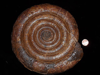
Alsatites proaries, Hettangian Ammonite
It is during the Hettangian that the smooth shelled ammonite genus Psiloceras first appears. They span the time between 201.3 ± 0.2 Ma and 199.3 ± 0.3 Ma (million years ago). For my European friends, the Hettangian is the time span in which the marine limestone, shales and clay Lias of western Europe were deposited.

This Hettangian ammonite, Alsatites proaries, is a lovely example of the cephalopods cruising our ancient oceans at that time. Alsatites is an extinct genus of cephalopod belonging to the Ammonite subclass. They lived during the Early Jurassic, Hettangian till the Sinemurian and are generally extremely evolute, many whorled with a broad keel. Or, as described by one of my very young friends, he looks like a coiled snake you make in pottery class.

The Hettangian is an interesting little period of our history. It spans the time between 201.3 ± 0.2 Ma and 199.3 ± 0.3 Ma (million years ago). For my European friends, the Hettangian is the time in which the marine limestone, shales and clay Lias of western Europe were deposited. In British Columbia, Canada, we see the most diverse middle and late Hettangian (Early Jurassic) ammonite assemblages in the Queen Charlotte Islands (Haida Gwaii), an archipelago about 50 km off British Columbia's northern Pacific coast. In total, 53 ammonite taxa are described of which Paradasyceras carteri, Franziceras kennecottense, Pleuroacanthites charlottensis, Ectocentrites pacificus and Curviceras haidae are new.

In general, North American Early Jurassic ammonites are of Tethyan affinity or endemic to the eastern Pacific. For this reason, a separate zonation for the Hettangian and Sinemurian of the Western Cordillera of North America was established. Taylor et al. (2001), wrote up and published on much of this early research though, at the time, very little Canadian information was included.

Longridge, L. M., et al. “Three New Species of the Hettangian (Early Jurassic) Ammonite Sunrisites from British Columbia, Canada.” Journal of Paleontology, vol. 82, no. 1, 2008, pp. 128–139. JSTOR, www.jstor.org/stable/20144175. Accessed 27 Jan. 2020.

Tozer, ET (Tim): Marine Triassic faunas of North America: Their significance for assessing plate and terrane movements. Geol Rundsch 71, 1077-1104 (1982). https://doi.org/10.1007/BF01821119

Danner, W. (Ted): Limestone resources of southwestern British Columbia. Montana Bur. Mines & Geol., Special publ. 74: 171-185, 1976.

Davis, G., Monger, JWH & Burchfiel, BC: Mesozoic construction of the Cordilleran “collage”, central British Columbia to central California. Pacific Coast Paleography symposium 2, Soc. Economic Paleontologists and Mineralogists, Los Angeles: 1-32, 1978.

Gibson, DW: Triassic rocks of the Rocky Mountain foothills and front ranges of northeastern British Columbia and west-central Alberta. Geol. Surv. Canada Bull. 247, 1975.

Photo of the large belemnite (Atractites sp?) and ammonites (Sunrisites & Badouxia) from the Lower Jurassic (Late Hettangian), Last Creek Formation (Castle Pass member), Taseko Lakes area, British Columbia, Canada in the collection of the deeply awesome John Fam.

Photo: A drawer of Juvavites sp. in the collections of the Geological Survey of Canada. These rarely seen Upper Triassic (Carnian to Norian) ammonoids were collected over many decades by geologists of the Geological Survey of Canada from Northeastern British Columbia. Photo care of the deeply awesome John Fam.

Photo: Grambergia sp. from the Early Anisian (Middle Triassic) ammonoid biostratigraphy of northeastern British Columbia, Canada. Collection of Fossil Huntress.

Photo: Alsatites proaries, Coll. Reiter, Neoammoniten, 30 July 2011, 19:26:10

Monday 9 January 2023

KWAGU'Ł INTO THE MIST

Kwagu'ł into the Mist by Heidi Henderson
Heidi Henderson is a Norwegian-Canadian Kwagu'ł Kwakwaka'wakw & proud citizen of the Central Council of Tlingit & Haida of Alaska living in British Columbia. 

Heidi grew up in Tsaxis, Fort Rupert, on northern Vancouver Island and is a direct blood descendant of Anisalaga, Master Chilkat Weaver and Raven of Tongass.

When she is not writing about natural history or filming it for television, she works in oil, acrylic, watercolour, Sterling Silver, wood, digital and other mixed media. Along with her visual designs, Heidi also designs clothing, jewellery and 3D sculptures. 

Sunday 1 January 2023

HUMPBACK WHALES: MEGAPTERA NOVAENGLIAE

Look deep into the knowing eye of this magnificent one. He is a Humpback whale, Megaptera novaeangliae, a species of baleen whale for whom I hold a special place in my heart. 

Baleens are toothless whales who feed on plankton and other wee oceanic tasties that they consume through their baleens, a specialised filter of flexible keratin plates that frame their mouth and fit within their robust jaws.

Baleen whales, the mysticetes, split from toothed whales, the Odontoceti, around 34 million years ago. The split allowed our toothless friends to enjoy a new feeding niche and make their way in a sea with limited food resources. There are fifteen species of baleen whales who inhabit all major oceans. Their number include our humbacks, grays, right whales and the massive blue whale. Their territory runs as a wide band running from the Antarctic ice edge to 81°N latitude. These filter feeders

In the Kwak̓wala language of the Kwakiutl or Kwakwaka'wakw, speakers of Kwak'wala, of the Pacific Northwest, and my cousins on my father's side, whales are known as g̱wa̱'ya̱m. Both the California grey and the Humpback whale live on the coast. Only a small number of individuals in First Nation society had the right to harpoon a whale. This is a practice from many years ago. It was generally only the Chief who was bestowed this great honour. Humpback whales like to feed close to shore and enter the local inlets. Around Vancouver Island and along the coast of British Columbia, this made them a welcome food source as the long days of winter passed into Spring.

Humpback whales are rorquals, members of the Balaenopteridae family that includes the blue, fin, Bryde's, sei and minke whales. The rorquals are believed to have diverged from the other families of the suborder Mysticeti during the middle Miocene. 

While cetaceans were historically thought to have descended from mesonychids—which would place them outside the order Artiodactyla—molecular evidence supports them as a clade of even-toed ungulates—our dear Artiodactyla. 

It is one of the larger rorqual species, with adults ranging in length from 12–16 m (39–52 ft) and weighing around 25–30 metric tons (28–33 short tons). The humpback has a distinctive body shape, with long pectoral fins and a knobbly head. It is known for breaching and other distinctive surface behaviours, making it popular with whale watchers and the lucky few who see them from the decks of our local ferries.

Both male and female humpback whales vocalize, but only males produce the long, loud, complex "song" for which the species is famous. Males produce a complex soulful song lasting 10 to 20 minutes, which they repeat for hours at a time. I imagine Gregorian Monks vocalizing their chant with each individual melody strengthening and complimenting that of their peers. All the males in a group produce the same song, which differed in each season. Its purpose is not clear, though it may help induce estrus in females and bonding amongst the males.

Humpback Whale, Megaptera novaeangliae
Found in oceans and seas around the world, humpback whales typically migrate up to 25,000 km (16,000 mi) each year. 

They feed in polar waters and migrate to tropical or subtropical waters to breed and give birth, fasting and living off their fat reserves. Their diet consists mostly of krill and small fish. 

Humpbacks have a diverse repertoire of feeding methods, including the bubble net technique.

Humpbacks are a friendly species that interact with other cetaceans such as bottlenose dolphins. They are also friendly and oddly protective of humans. You may recall hearing about an incident off the Cook Islands a few years back. Nan Hauser was snorkelling and ran into a tiger shark. Two adult humpback whales rushed to her aid, blocking the shark from reaching her and pushing her back towards the shore. We could learn a thing or two from their kindness. We have not been as good to them as they have been to us.

Like other large whales, the humpback was a tasty and profitable target for the whaling industry. My grandfather and uncle participated in that industry out of Coal Harbour on northern Vancouver Island back in the 1950s. So did many of my First Nation cousins. My cousin John Lyon has told me tales of those days and the slippery stench of that work.

Six whaling stations operated on the coast of British Columbia between 1905 and 1976. Two of these stations were located at Haida Gwaii, one at Rose Harbour and the other at Naden Harbour. Over 9,400 large whales were taken from the waters around Haida Gwaii. The catch included blue whales, fin whales, sei whales, humpback whales, sperm whales and right whales. In the early years of the century, primarily humpback whales were taken. In later years, fin whales and sperm whales dominated the catch. 

Whales were hunted off South Moresby in Haida Gwaii, on the north side of Holberg Inlet in the Quatsino Sound region. It was the norm at the time and a way to make a living, especially for those who had hoped to work in the local coal mine but lost their employment when it shut down. 

While my First Nations relatives hunted whales in small numbers and many years ago, my Norwegian relatives participated in the hunt on a scale that nearly led to their extinction before the process was banned. The Coal Harbour Whaling Station closed in 1967. Once it had closed, my grandfather Einar Eikanger, my mother's father, took to fishing and my uncle Harry lost his life the year before when he slipped and fell over the side of the boat. He was crushed between the hull and a Humpback in rough seas. 

Humpback populations have partially recovered since that time to build their population up to 80,000 animals worldwide—but entanglement in fishing gear, collisions with ships, and noise pollution continue to negatively impact the species. So be kind if you see them. Turn your engine off and see if you can hear their soulful cries echoing in the water.

I did up a video on Humpback Whales over on YouTube so you could see them in all their majesty. Here is the link: https://youtu.be/_Vbta7kQNoM

Wednesday 21 December 2022

HAIDA GWAII: ISLAND OF THE PEOPLE

A wreck with tales to tell at Naikoon, Haida Gwaii. The islands have gone by many names. To the people who call the islands home, Haida Gwaii means “island of the people,” it is a shortened version of an earlier name, Haadala Gwaii-ai, or “taken out of concealment.” 

Back at the time of Nangkilslas, it was called Didakwaa Gwaii, or “shoreward country.” 

By any name, the islands are a place of rugged beauty and spirit and enjoy a special place in both the natural and supernatural world. The enormous difference between high and low tide in Haida Gwaii – up to twenty three vertical feet – means that twice a day, vast swathes of shellfish are unveiled, free for the taking. 

An ancient Haida saying is still often heard today, “When the tide is out, the table is set.” Archaeological evidence shows that by about five thousand years ago, gathering shellfish replaced hunting and fishing as their primary food source. The shellfish meat was skewered on sticks, smoked and stored for use in winter or for travel.

Steeped in mist and mythology, the islands of Haida Gwaii abound in local lore that surrounds their beginnings. Today, the Hecate Strait is a tempestuous 40-mile wide channel that separates the mist-shrouded archipelago of Haida Gwaii from the BC mainland. Haida oral tradition tells of a time when the strait was mostly dry, dotted here and there with lakes. During the last ice age, glaciers locked up so much water that the sea level was hundreds of feet lower than it is today. Soil samples from the sea floor contain wood, pollen, and other terrestrial plant materials that tell of a tundra-like environment.

The islands of Haida Gwaii are at the western edge of the continental shelf and form part of Wrangellia, an exotic terrane of former island arcs, which also includes Vancouver Island, parts of western mainland British Columbia and southern Alaska. 

Brewericeras hulenense (Anderson, 1938)
While we’ll see that there are two competing schools of thought on Wrangellia’s more recent history, both sides agree that many of the rocks, and the fossils they contain, were laid down somewhere near the equator. 

They had a long, arduous journey, first being pushed by advancing plates, then being uplifted, intruded, folded, and finally thrust up again. It’s reminiscent of how pastry is balled up, kneaded over and over, finally rolled out, then the process is repeated again.

This violent history applies to most of the rock that makes up the Insular Belt, the outermost edge of the Cordillera. Once in their present location, the rocks that make up the mountains and valleys of this island group were glaciated and eroded to their present form. Despite this tumultuous past, the islands have arguably the best-preserved and most fossil-rich rocks in the Canadian Cordillera, dating from very recent to more than 200 million years old. 

The fossils found in the Triassic rock of Wrangellia are equatorial or low latitude life forms quite different from those found today on the Continent at the latitude of Haida Gwaii. This suggests those rocks were in the equatorial region during the Late Triassic, just over 200 million years ago. 

The Lower Jurassic ammonite faunas found at Haida Gwaii are very similar to those found in the Eastern Pacific around South America and in the Mediterranean. The strata exposed at Maple Island, Haida Gwaii are stratigraphically higher than the majority of Albian localities in Skidegate Inlet. The macrofossil fauna belonged to the Upper part of the Sandstone Member of the Haida formation.

The western end of the island contains numerous well-preserved inoceramids such as Birostrina concentrica and a few rare ammonites of Desmoceras bearskinese. The eastern shores are home to unusual ammonite fauna in the finer grained sandstones. Here we find the fossils as extremely hard concretions while others were loose in the shale. Species include Anagaudryceras sacya and Tetragonites subtimotheanus. A large whorl section of the rare Ammonoceratites crenucostatus has also been found here. The ammonites, Desmoceras; Brewericeras hulenense; Cleoniceras perezianum, Douvelliceras spiniferum are all found in Lower Cretaceous, Middle Albian, Haida Formation deposits.

Thursday 8 December 2022

CASTLE PEAK: JET RANGER

If you look closely, you can see a wee jet ranger helicopter hovering over a very chilly Castle Peak in the southern Chilcotin Range, British Columbia, Canada. 

Castle Peak was our glorious landmark and loadstone of basalt that marked the spot on our Jurassic/Triassic palaeo adventures collecting about 7000 ft. The peak itself reaches higher still to around 8,176 ft.

The late Hettangian ammonite fauna from Taseko Lakes is diverse and relatively well‐preserved. Over three field seasons from 2001-2003, thirty-five taxa from the Mineralense and Rursicostatum zones were studied and three new species were discovered and named: Fergusonites hendersonae, Eolytoceras constrictum and Pseudaetomoceras victoriense. This material is very important as it greatly expands our understanding of the fauna and ranges of ammonites currently included in the North American regional ammonite zonation. 

Fergusonites hendersonae (Longridge, 2008)
I had the very great honour of having the newly named, Fergusonites hendersonae, a new species of nektonic carnivorous ammonite, named after me by palaeontologist Louse Longridge from the University of British Columbia. 

I had met Louise as an undergrad and was pleased as punch to hear that she would be continuing the research by Dr. Howard Tipper, the authority on this area of the Chilcotins and Haida Gwaii — which he dearly loved. 

"Tip" was a renowned Jurassic ammonite palaeontologist and an excellent regional mapper who mapped large areas of the Cordillera. He made significant contributions to Jurassic paleobiogeography and taxonomy in collaboration with Dr. Paul Smith, Head of Earth and Ocean Science at the University of British Columbia. 

Tip’s regional mapping within BC has withstood the test of time and for many areas became the region's base maps for future studies. The scope of Tip’s understanding of Cordilleran geology and Jurassic palaeontology will likely never be matched. He passed away on April 21, 2005. His humour, knowledge and leadership will be sorely missed. 

Before he left us, he shared that knowledge with many of whom would help to secure his legacy for future generations. We did several trips over the years up to the Taseko Lake area of the Rockies joined by many wonderful researchers from the Vancouver Island Palaeontological Society and Vancouver Paleontological Society, as well as the University of British Columbia. Both Dan Bowen and John Fam were instrumental in planning those expeditions and each of them benefited greatly from the knowledge of Dr. Howard Tipper. 

If not for Tipper's early work in the region, our shared understanding and much of what was accomplished in his last years and after his passing would not have been possible. 

Over the course of three field seasons, we endured elevation sickness, rain, snow, grizzly bears and very chilly nights  — we were sleeping right next to a glacier at one point — but were rewarded by the enthusiastic crew, and helicopter rides — which really cut down the hiking time — excellent specimens including three new species of ammonites, along with a high-spired gastropod and lobster claw that have yet to be written up. This area of the world is wonderful to hike and explore — a stunningly beautiful country. We were also blessed with access as the area is closed to all fossil collecting except with a permit.